ATL: SANDY - Remnants - Discussion

Moderator: S2k Moderators

Message
Author
User avatar
brunota2003
S2K Supporter
S2K Supporter
Posts: 9476
Age: 34
Joined: Sat Jul 30, 2005 9:56 pm
Location: Stanton, KY...formerly Havelock, NC
Contact:

Re: ATL: SANDY - Hurricane - Discussion

#2081 Postby brunota2003 » Sat Oct 27, 2012 11:06 pm

MHurricanes wrote:From Dr. Ryan Maue, who is head of Meteorological Applications Research
at Weatherbell.com

@RyanMaue 8m GFS 00z Devastating track for #Sandy from hours 48-54 into S. New Jersey. Extreme winds on north side of storm: pic.twitter.com/GKrpuBOW

https://twitter.com/RyanMaue/status/262 ... 24/photo/1

There are 100 to 110 knot winds, at the 900 mb level, sitting over Long Island in that image. If those get anywhere near the surface, especially with high rises...yikes.
0 likes   
Just a small town southern boy helping other humans.

User avatar
vbhoutex
Storm2k Executive
Storm2k Executive
Posts: 29113
Age: 73
Joined: Wed Oct 09, 2002 11:31 pm
Location: Cypress, TX
Contact:

Re:

#2082 Postby vbhoutex » Sat Oct 27, 2012 11:35 pm

monsoon wrote:Won't there be wave action on top of the combined tide + storm surge?

Yes there will be plenty of wave action on top of it. With Irene the seawall in lower Manhattan(?) was 1 foot from being overtopped. Current forecasts are putting the surge expected in NYC area at 1 foot more than during Irene. If this verifies it means there will definitely be flooding in some areas of NYC which could possibly include the subway system if they aren't properly "water proofed".
0 likes   
Skywarn, C.E.R.T.
Please click below to donate to STORM2K to help with the expenses of keeping the site going:
Image

CrazyC83
Professional-Met
Professional-Met
Posts: 34002
Joined: Tue Mar 07, 2006 11:57 pm
Location: Deep South, for the first time!

Re: Re:

#2083 Postby CrazyC83 » Sat Oct 27, 2012 11:42 pm

vbhoutex wrote:
monsoon wrote:Won't there be wave action on top of the combined tide + storm surge?

Yes there will be plenty of wave action on top of it. With Irene the seawall in lower Manhattan(?) was 1 foot from being overtopped. Current forecasts are putting the surge expected in NYC area at 1 foot more than during Irene. If this verifies it means there will definitely be flooding in some areas of NYC which could possibly include the subway system if they aren't properly "water proofed".


How high can sandbags realistically be placed to protect the NYC subways?
0 likes   

User avatar
Infdidoll
Category 2
Category 2
Posts: 667
Age: 47
Joined: Thu Oct 01, 2009 8:39 pm
Location: Temecula, CA

#2084 Postby Infdidoll » Sun Oct 28, 2012 12:10 am

What the heck? I move from Okinawa where we got slammed by typhoons repeatedly to northern Virginia...Where we may be impacted by a hurricane? :double:

Trying to convince my husband that this could be a much different experience than all the past typhoons we've experienced in our nice, concrete bunker in Okinawa and that we should get prepared. We're so used to weathering the storm safely indoors with little damage and having electricity withstand winds over 100 mph with no issues whatsoever.

I don't know how much of this storm we'll see, but if it gets as crazy as predicted, it will be a different experience. We're surrounded by gorgeous, very tall trees in a wood framed house. I guess we'll see! :eek:
0 likes   

ozonepete
Professional-Met
Professional-Met
Posts: 4743
Joined: Mon Sep 07, 2009 3:23 pm
Location: From Ozone Park, NYC / Now in Brooklyn, NY

Re:

#2085 Postby ozonepete » Sun Oct 28, 2012 12:41 am

Infdidoll wrote:What the heck? I move from Okinawa where we got slammed by typhoons repeatedly to northern Virginia...Where we may be impacted by a hurricane? :double:

Trying to convince my husband that this could be a much different experience than all the past typhoons we've experienced in our nice, concrete bunker in Okinawa and that we should get prepared. We're so used to weathering the storm safely indoors with little damage and having electricity withstand winds over 100 mph with no issues whatsoever.

I don't know how much of this storm we'll see, but if it gets as crazy as predicted, it will be a different experience. We're surrounded by gorgeous, very tall trees in a wood framed house. I guess we'll see! :eek:


Hey there, great to see you! I remember you from the West Pac discussions. So I guess these storms follow you, lol. Anyway, in all seriousness please be careful, even though I know you know what to do in these situations. Stay safe.
0 likes   

User avatar
Infdidoll
Category 2
Category 2
Posts: 667
Age: 47
Joined: Thu Oct 01, 2009 8:39 pm
Location: Temecula, CA

Re: Re:

#2086 Postby Infdidoll » Sun Oct 28, 2012 12:48 am

ozonepete wrote:
Infdidoll wrote:What the heck? I move from Okinawa where we got slammed by typhoons repeatedly to northern Virginia...Where we may be impacted by a hurricane? :double:

Trying to convince my husband that this could be a much different experience than all the past typhoons we've experienced in our nice, concrete bunker in Okinawa and that we should get prepared. We're so used to weathering the storm safely indoors with little damage and having electricity withstand winds over 100 mph with no issues whatsoever.

I don't know how much of this storm we'll see, but if it gets as crazy as predicted, it will be a different experience. We're surrounded by gorgeous, very tall trees in a wood framed house. I guess we'll see! :eek:


Hey there, great to see you! I remember you from the West Pac discussions. So I guess these storms follow you, lol. Anyway, in all seriousness please be careful, even though I know you know what to do in these situations. Stay safe.


I'm telling you! My luck! And here I was thinking I'd be missing the adrenaline rush of scrambling before a storm! lol - We'll be fine, I'm sure. We'll get to the store tomorrow and stock up on some supplies and partake in the requisite outdoors clean-up...Funny, I'll probably be much more nervous during this storm than I was in Okinawa. I've been spoiled sitting cozy and warm through typhoons still having full TV and internet access because of Okinawa's solid power grid. I'm off to get some sleep! Lots of work to do tomorrow.
0 likes   

ozonepete
Professional-Met
Professional-Met
Posts: 4743
Joined: Mon Sep 07, 2009 3:23 pm
Location: From Ozone Park, NYC / Now in Brooklyn, NY

Re: ATL: SANDY - Hurricane - Discussion

#2087 Postby ozonepete » Sun Oct 28, 2012 2:00 am

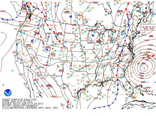
Latest surface chart from HPC and RGB satelite:

Image

Image
0 likes   

User avatar
Kingarabian
S2K Supporter
S2K Supporter
Posts: 16014
Joined: Sat Aug 08, 2009 3:06 am
Location: Honolulu, Hawaii

#2088 Postby Kingarabian » Sun Oct 28, 2012 2:46 am

I know yall be worried bout this major threat to NJ. But we got a Tsunami coming our way. Haha 2012 for sure.

God Bless America! :flag:
0 likes   
RIP Kobe Bryant

User avatar
WxEnthus
Category 1
Category 1
Posts: 261
Joined: Thu Jun 09, 2011 9:33 am
Location: Eastern U.S.

Re: ATL: SANDY - Hurricane - Discussion

#2089 Postby WxEnthus » Sun Oct 28, 2012 3:08 am

CrazyC83 wrote:Here is my impact estimate for the region:
http://img715.imageshack.us/img715/910/storm1012.jpg


Great map, I think you've outlined the risks fairly well by location. I'm sitting here in the mountains near the VA/WV border. Lots of people talking excitedly asking, "Will it snow?" and the other half seem to be rolling their eyes with an attitude of, "It's not gonna snow, that's ridiculous."

People seem to be ignoring the real concern -- the wind. Our area was hit pretty hard by the derecho that came through earlier this year. Some people were without power for weeks, so you'd think they'd sit up and pay attention when the news continuously reports this as a wind threat. And the cold, that'd be my next concern, especially with regard to possible power outages. The weather has been so calm and warm that it's going to be a real shock for some folks. I stepped outside for a quick break today with some co-workers and they were really surprised at the damp chill in the air, despite the forecast saying for days now that it's going to get COLD. A lot of people have not had to turn their heat on yet this season, meaning they may not have firewood ready, may not have had fuel delivered for gas heating systems, etc.

Here the first leaves just started to fall this week. Lots of trees are still green and full, including the three huge maples trees in/near my yard. If it *does* snow it will be wet and heavy, the kind that is sure to stick to everything -- except perhaps the ground, which is very warm from a week of unseasonably beautiful 85 degree sunny days.

We're not in the red zone, not near the coast, not in a neighborhood at risk for flooding, not likely to see structural damage from winds. But if our power goes out we could be out for a while. And the temperatures are going to be in the 30s & 40s for several days in a row. Since we're somewhat rural and isolated we get moved to the bottom of the priority list in getting power restored, especially if more populated areas are impacted, which is exactly what's predicted with this storm.

So we've stocked up on basic supplies, have everything charged up, and have made arrangements with friends & family for a place to stay in case we are without power longer than a day or two. Some other weather-wise folks in the area have done the same. But most people are thinking we'll have a few breezes and maybe see a snowflake or two and that's about all the thought they've given it. I hope people in the high-impact areas near the coast and to the north of us are taking this more seriously.
0 likes   
    Disclaimer: Posts herein are my amateur opinion only and should not be used for making important decisions. Defer to the NHC, NWS, and local authorities for official guidance.

User avatar
GCANE
S2K Supporter
S2K Supporter
Posts: 11501
Joined: Mon Oct 22, 2007 8:03 am

Re: ATL: SANDY - Hurricane - Discussion

#2090 Postby GCANE » Sun Oct 28, 2012 5:32 am

Latest AMSU core temp profile:

Max at 4C above ambient, 500mb

http://amsu.ssec.wisc.edu/archive/2012/ ... _xsect.gif
0 likes   

User avatar
cycloneye
Admin
Admin
Posts: 145603
Age: 68
Joined: Thu Oct 10, 2002 10:54 am
Location: San Juan, Puerto Rico

Re: ATL: SANDY - Hurricane - Discussion

#2091 Postby cycloneye » Sun Oct 28, 2012 6:39 am

Closeup view of Delmarva Peninsula.

Image
0 likes   
Visit the Caribbean-Central America Weather Thread where you can find at first post web cams,radars
and observations from Caribbean basin members Click Here

User avatar
syfr
S2K Supporter
S2K Supporter
Posts: 170
Age: 106
Joined: Fri Oct 26, 2012 7:33 pm
Location: East Central NC

Re: ATL: SANDY - Hurricane - Discussion

#2092 Postby syfr » Sun Oct 28, 2012 6:46 am

sandyb wrote:I live in Newport we have had high winds Cherry Pt. had 48 mph earlier I live about 3 miles south of there


I'm in Johnston County, 100 miles from the coast and we've had gusts to 30. No drama, but the wind chimes haven't been quiet in 24 hours now.

John
0 likes   
I'm not a meteorologist, I'm an electronics engineer. While I can probably fix your toaster oven, you're not going to learn about storms from me!

New Mexico had no hurricanes. Then I moved to NC right before Fran.....

jinftl
Category 5
Category 5
Posts: 4312
Joined: Tue Aug 31, 2004 4:47 pm
Location: fort lauderdale, fl

Re: ATL: SANDY - Hurricane - Discussion

#2093 Postby jinftl » Sun Oct 28, 2012 7:07 am

Pressure down to 951 mb...winds at 75 mph still. Huge huge tropical storm windfield. This really looks like it is beginning to transition or at least blend to a non-tropical powerhouse. This is now stronger than the 1993 Superstorm in pressure (that was 960mb and had no name...nuff said)

After North Carolina's tropical storm warning, there are no NHC watches or warnings in effect. I am thinking they may continue advisories even if this is pretty clearly no longer a true tropical hurricane (non-hurricane does not mean non-hurricane force winds occurring...) because if they stop advisories the sense of urgency and severity may decrease in folk's eyes.

NHC Director Dr. Knabb on TWC now...he re-emphasizing that the high wind warnings in effect north of North Carolina aren't less and areas north of NC could see wind gusts approaching hurricane force.


From NHC this a.m.:

THE MOST RECENT AIR FORCE HURRICANE HUNTER AIRCRAFT MISSION DID NOT
FIND WINDS OF HURRICANE FORCE NEAR THE CENTER OF SANDY.
HOWEVER...EARLIER DROPSONDE DATA INDICATED THAT WINDS TO HURRICANE
STRENGTH WERE OCCURRING WELL TO THE SOUTH AND SOUTHWEST OF THE
CENTER...BEYOND THE RADIAL LEGS COVERED BY THIS AIRCRAFT. ALTHOUGH
IT COULD BE GENEROUS...THE INTENSITY IS HELD AT 65 KT FOR THIS
ADVISORY. AIRCRAFT AND DROPSONDE DATA LATER TODAY SHOULD PROVIDE
ADDITIONAL INFORMATION ON THE INTENSITY OF SANDY. THE VERTICAL
SHEAR HAS DECREASED AND THE SYSTEM HAS BEEN MAINTAINING A SMALL
AREA OF DEEP CONVECTION NEAR THE CENTER. THEREFORE...THERE IS STILL
SOME SHORT-TERM POTENTIAL FOR SANDY TO INTENSIFY AS A TROPICAL
CYCLONE...ESPECIALLY SINCE IT WILL BE TRAVERSING THE GULF STREAM
TODAY. IN THE 24 TO 48 HOUR TIME FRAME...THE GLOBAL MODELS SHOW
INTENSIFICATION OF THE CYCLONE WHICH IS UNDOUBTEDLY DUE TO
BAROCLINIC PROCESSES...AS THE SYSTEM WILL BE MOVING OVER MUCH
COLDER WATERS BY THAT TIME.
Last edited by jinftl on Sun Oct 28, 2012 7:14 am, edited 1 time in total.
0 likes   

WeatherGuesser
Category 5
Category 5
Posts: 2672
Joined: Tue Jun 29, 2010 6:46 am

Re: ATL: SANDY - Hurricane - Discussion

#2094 Postby WeatherGuesser » Sun Oct 28, 2012 7:11 am

jinftl wrote:After North Carolina's tropical storm warning, there are no NHC watches or warnings in effect.


By the book or not, that's clearly a mistake. Sometimes you have to fudge the rules in the interests of public safety.
0 likes   

User avatar
StormingB81
S2K Supporter
S2K Supporter
Posts: 5676
Age: 43
Joined: Thu Aug 27, 2009 1:45 am
Location: Rockledge, Florida

#2095 Postby StormingB81 » Sun Oct 28, 2012 7:14 am

So far at my location we have had almost 5 1/2 inches of rain...winds still haven't been that bad. They say today we should be seeing winds frequently gusting over 50 mph. Hope these trees stay up and there isn't a lot of power outages...
0 likes   

jinftl
Category 5
Category 5
Posts: 4312
Joined: Tue Aug 31, 2004 4:47 pm
Location: fort lauderdale, fl

Re: ATL: SANDY - Hurricane - Discussion

#2096 Postby jinftl » Sun Oct 28, 2012 7:19 am

This is an interesting one for sure...if it weren't for the TS Warnings on parts of the NC coast and Bermuda (how nuts is that the reach goes to Bermuda!)...the forecasts and warnings for high wind, etc would fall on NWS offices and not the NHC. Kinda why I am thinking why they may keep this named and under NHC advisories until landfall even if it is not technically a tropical system by definition (starting to take on a more extratropical look now even) tonight and tomorrow.

To have NHC coverage and updates for the last week and to have those stop just as the storm is approaching 60 million people may send a confusing message (talking to you Bloomberg...non-hurricane does not mean non-hurricane intensity in every aspect)

WeatherGuesser wrote:
jinftl wrote:After North Carolina's tropical storm warning, there are no NHC watches or warnings in effect.


By the book or not, that's clearly a mistake. Sometimes you have to fudge the rules in the interests of public safety.
0 likes   

User avatar
GCANE
S2K Supporter
S2K Supporter
Posts: 11501
Joined: Mon Oct 22, 2007 8:03 am

Re: ATL: SANDY - Hurricane - Discussion

#2097 Postby GCANE » Sun Oct 28, 2012 7:35 am

Looks Sandy is now cutoff from any high theta-e air coming up from the tropics.

http://tropic.ssec.wisc.edu/real-time/m ... t72hrs.gif
0 likes   

jinftl
Category 5
Category 5
Posts: 4312
Joined: Tue Aug 31, 2004 4:47 pm
Location: fort lauderdale, fl

Re: ATL: SANDY - Hurricane - Discussion

#2098 Postby jinftl » Sun Oct 28, 2012 7:37 am

Crownweather graphic from Sunday morning update

Image

Image
Last edited by jinftl on Sun Oct 28, 2012 7:38 am, edited 1 time in total.
0 likes   

Andy_L
Category 1
Category 1
Posts: 257
Joined: Fri Sep 10, 2004 8:03 am
Location: Ottawa, Canada

Re: ATL: SANDY - Hurricane - Discussion

#2099 Postby Andy_L » Sun Oct 28, 2012 7:37 am

GCANE wrote:Looks Sandy is now cutoff from any high theta-e air coming up from the tropics.

http://tropic.ssec.wisc.edu/real-time/m ... t72hrs.gif


could you explain what that means and how it will affect the storm please?
0 likes   

CrazyC83
Professional-Met
Professional-Met
Posts: 34002
Joined: Tue Mar 07, 2006 11:57 pm
Location: Deep South, for the first time!

Re: ATL: SANDY - Hurricane - Discussion

#2100 Postby CrazyC83 » Sun Oct 28, 2012 7:39 am

WxEnthus wrote:
CrazyC83 wrote:Here is my impact estimate for the region:
http://img715.imageshack.us/img715/910/storm1012.jpg


Great map, I think you've outlined the risks fairly well by location. I'm sitting here in the mountains near the VA/WV border. Lots of people talking excitedly asking, "Will it snow?" and the other half seem to be rolling their eyes with an attitude of, "It's not gonna snow, that's ridiculous."

People seem to be ignoring the real concern -- the wind. Our area was hit pretty hard by the derecho that came through earlier this year. Some people were without power for weeks, so you'd think they'd sit up and pay attention when the news continuously reports this as a wind threat. And the cold, that'd be my next concern, especially with regard to possible power outages. The weather has been so calm and warm that it's going to be a real shock for some folks. I stepped outside for a quick break today with some co-workers and they were really surprised at the damp chill in the air, despite the forecast saying for days now that it's going to get COLD. A lot of people have not had to turn their heat on yet this season, meaning they may not have firewood ready, may not have had fuel delivered for gas heating systems, etc.

Here the first leaves just started to fall this week. Lots of trees are still green and full, including the three huge maples trees in/near my yard. If it *does* snow it will be wet and heavy, the kind that is sure to stick to everything -- except perhaps the ground, which is very warm from a week of unseasonably beautiful 85 degree sunny days.

We're not in the red zone, not near the coast, not in a neighborhood at risk for flooding, not likely to see structural damage from winds. But if our power goes out we could be out for a while. And the temperatures are going to be in the 30s & 40s for several days in a row. Since we're somewhat rural and isolated we get moved to the bottom of the priority list in getting power restored, especially if more populated areas are impacted, which is exactly what's predicted with this storm.

So we've stocked up on basic supplies, have everything charged up, and have made arrangements with friends & family for a place to stay in case we are without power longer than a day or two. Some other weather-wise folks in the area have done the same. But most people are thinking we'll have a few breezes and maybe see a snowflake or two and that's about all the thought they've given it. I hope people in the high-impact areas near the coast and to the north of us are taking this more seriously.


That's why I placed an overlapping blue zone to highlight the extra dangers while showing the wind threat as well, and also mentioned that local impacts may exceed (or be below) the general colors shown. Some places in the orange zone will get hit harder than some places in the red zone as a result.

I see no reason to change the map at this time; I think I am covering all the bases.
0 likes   


Return to “2012”

Who is online

Users browsing this forum: No registered users and 10 guests