jinftl wrote:Afternoon discussion from Dr. Masters on 94L...just like any system, this one may have to deal with some degree of shear and dry air at times, but Dr. M seems to think 94L will overcome it. Quite honestly, any slowing of the deveolopment process just means a system that will make it further west on the low level flow and that could be the thing we don't want to see!
I will say, I have rarely seen Dr. Masters be as bold as to say this far out that the system has a 60% chance of passing through the Lesser Antilles at unspecified intensity.
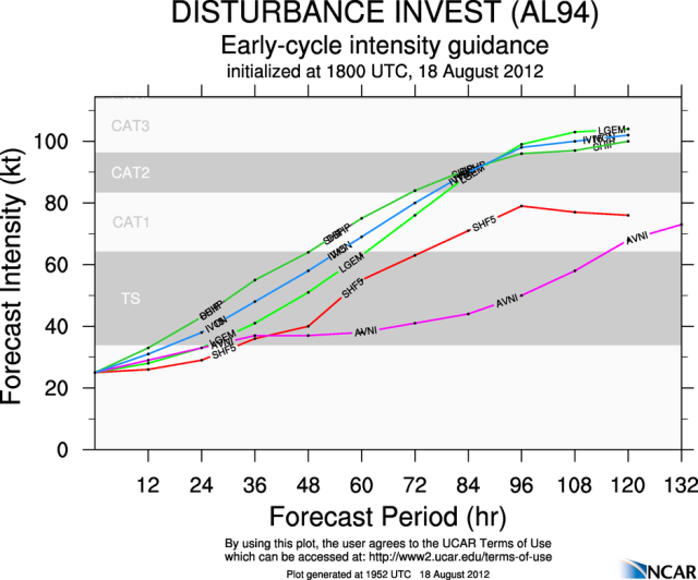
Forecast for 94L
The latest 2 pm EDT run of the SHIPS model predicts that wind shear will be low, 5 - 10 knots, and ocean temperatures will fluctuate around 28°C over the next five days, as 94L tracks westwards towards the Lesser Antilles. As is typical with storms making the crossing from Africa to the Antilles, dry air to the north will likely interfere with development, and the SHIPS model predicts increased dry air as 94L approaches the Lesser Antilles. However, with shear expected to be low, dry air may be less of an issue for 94L than it was for Ernesto or TD 7.
The storm should maintain a nearly due west track through Monday night, to a point near 50°W, about 700 miles east of the Lesser Antilles. At that point, a trough of low pressure passing to the north of 94L may be able to pull the storm to the northwest well to the northeast of the Lesser Antilles, as suggested by the latest 12Z (8 am EDT) run of the NOGAPS model. The 12Z UKMET model shows a more west-northwesterly motion resulting in a near miss of the Lesser Antilles on Thursday. Our two best performing models--the GFS and ECMWF--have both been taking 94L through the Lesser Antilles with every run for the past 24 hours, though. The latest 12Z run of both models now agree on the timing, with 94L arriving Wednesday night or Thursday morning. The BAMM model, which performed as well as the ECMWF and GFS at 5-day forecasts in 2011, is also showing a track through the Lesser Antilles. Given this agreement among our top three models for long-range forecasts, I give a 60% chance that 94L will pass through the Lesser Antilles. In their 2 pm EDT Tropical Weather Outlook, NHC gave 94L a 50% chance of developing into a tropical depression by Monday afternoon.
http://www.wunderground.com/blog/JeffMa ... rynum=2192
And making two blogs about it is not common,meaning he see this as a serious threat down the road.