
Brigantine is just north of Atlantic City.
Moderator: S2k Moderators


cycloneye wrote:Does anyone has a graphic of New Jersey to see where Brigantine Island is located?


CronkPSU wrote:is this the kind of storm that can create new islands and channels and alter geography like what happened with Assateague and others in years past?


summersquall wrote:http://i50.tinypic.com/1zl6oie.jpg
Brigantine is just north of Atlantic City.

cycloneye wrote:Does anyone has a graphic of New Jersey to see where Brigantine Island is located?
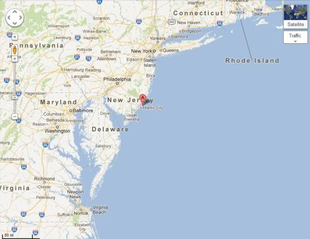


ozonepete wrote:cycloneye wrote:Does anyone has a graphic of New Jersey to see where Brigantine Island is located?
Here, Luis. At the circled A, to give you the wide perspective...
http://i189.photobucket.com/albums/z174 ... dnjmap.jpg
cycloneye wrote:ozonepete wrote:cycloneye wrote:Does anyone has a graphic of New Jersey to see where Brigantine Island is located?
Here, Luis. At the circled A, to give you the wide perspective...
http://i189.photobucket.com/albums/z174 ... dnjmap.jpg
Thank you oz. The forecast track is just south of that island.
ozonepete wrote:clipper35 wrote:ozone nice map but you have that center of sandy that far north into nj most forcasts are now saying southern new jersey yoy know something that we dont?
I have said since Thursday evening, given the model output, the center comes ashore between Long Beach Island and Sandy Hook. But landfall anywhere from Atlantic City northward to NYC will be devastating at the coast from central Jersey to most of Long Island. Just does not look very hopeful.
IntheEye wrote:ozonepete wrote:clipper35 wrote:ozone nice map but you have that center of sandy that far north into nj most forcasts are now saying southern new jersey yoy know something that we dont?
I have said since Thursday evening, given the model output, the center comes ashore between Long Beach Island and Sandy Hook. But landfall anywhere from Atlantic City northward to NYC will be devastating at the coast from central Jersey to most of Long Island. Just does not look very hopeful.
Hey Ozonepete, the NHC track seems to take Sandy just south of Atlantic City. Do you still stand by your earlier thoughts? Thanks for your input
Weatherguy173 wrote:if anyone knows where essex county is in new jersey, do you think the power will be lost?
Users browsing this forum: No registered users and 32 guests


