ATL: SANDY - Remnants - Discussion

Moderator: S2k Moderators

Message
Author
User avatar
weatherwindow
Category 4
Category 4
Posts: 904
Joined: Mon Sep 20, 2004 9:48 am
Location: key west/ft lauderdale

Re:

#2581 Postby weatherwindow » Mon Oct 29, 2012 6:19 am

KWT wrote:Pressure down to 941mbs now, looks like Sandy is indeed strengthening, and looking at it, its still tropical strengthening as well as convection is deepening again.


Recalling those earlier Euro forecast landfall pressures ...932mb, no way, now perhaps way :eek:
0 likes   

User avatar
Cyclenall
Category 5
Category 5
Posts: 6666
Joined: Thu Jun 08, 2006 10:01 pm
Location: Ontario, Canada

Re: ATL: SANDY - Hurricane - Discussion

#2582 Postby Cyclenall » Mon Oct 29, 2012 6:22 am

Hey Its Me wrote:
Cyclenall wrote: Yep, I saw that. However it seems every time there is a VDM its never aligned to the Hdobs or whatever for Sandy which is another non-starter.


Don't shoot the messenger... ;)


I think this is actually a new significant low for this specific reading.

It happened again.
0 likes   

storm4u
Category 2
Category 2
Posts: 651
Joined: Wed Aug 11, 2004 7:26 am
Location: agawam, ma
Contact:

#2583 Postby storm4u » Mon Oct 29, 2012 6:36 am

many people up here are talking about how pink the sky is
0 likes   

tolakram
Admin
Admin
Posts: 20012
Age: 62
Joined: Sun Aug 27, 2006 8:23 pm
Location: Florence, KY (name is Mark)

Re: ATL: SANDY - Hurricane - Discussion

#2584 Postby tolakram » Mon Oct 29, 2012 6:45 am

0 likes   
M a r k
- - - - -
Join us in chat: Storm2K Chatroom Invite. Android and IOS apps also available.

The posts in this forum are NOT official forecasts and should not be used as such. Posts are NOT endorsed by any professional institution or STORM2K.org. For official information and forecasts, please refer to NHC and NWS products.

User avatar
opticsguy
S2K Supporter
S2K Supporter
Posts: 231
Joined: Wed Jan 05, 2011 9:27 pm
Location: McKinney, TX

#2585 Postby opticsguy » Mon Oct 29, 2012 6:48 am

Excerpt from KJFK forecaster discussion. A good summary. Scary

Potentially life threatening destructive storm surge event for the New Jersey and New York coasts.

Sandy appears to be getting ready to turn toward the northwest in
response to increasing upstream blocking as an upper high builds
westward into the Canadian Maritimes...and as the storm first
undergoes fujiwara interaction with and then merges with a digging
closed low to its west. This infusion of baroclinic energy will
enable Sandy to maintain or increase in intensity...transforming
into a severe Post-tropical cyclone and making landfall on the
central or southern New Jersey coast early this evening. The already large
wind field around Sandy should expand and intensify today...with
sustained winds of 35-45 miles per hour expected by middle to late
afternoon...and 40-55 miles per hour this evening. All nwp in pretty close
agreement on development and placement of a band of very strong
925 mb winds of 70-90 knots to the north of the cyclone by late
afternoon over our County Warning Area...especially across coastal sections.
A shallow mixed layer below that...in combination with possible
Gravity wave ducting just north of a warm front developing to the
northeast of Sandy...could allow a large portion of these strong
winds to mix down...especially in heavier rain...so at least
occasional gusts 60-75 miles per hour expected in NE-east flow during middle to
late afternoon before the storm makes landfall.


Of even greater concern is a second band of forecast 925 mb winds of
similar strength on the southeast flank of the cyclone that should rotate
up into the County Warning Area during and just after landfall this
evening...initially impacting southern CT and Long Island...then
translating westward into NYC metropolitan and the lower Hudson Valley.
Steepening low level lapse rates in this quadrant of the storm
as cold air advection begins just off the deck...but as low level warm air advection
continues...should lead to even more efficient momentum
Transfer...with the strongest winds expected along the south
shores of Long Island and CT where winds could gust 80 to perhaps
90 miles per hour. There may be a low end tornado threat across eastern
CT/Long Island during this time via strong low level helicity and
development of marginal low level cape...not enough for thunder
initially but enough for low-topped convection that could stretch
rotating updrafts and/or tap into higher momentum aloft.


Winds will slowly diminish overnight...but will still be gusting
up to 45-50 miles per hour at daybreak.


The combination of event duration...saturated grounds...and
partial to nearly full tree canopies...would cause widespread
Downing of trees and power lines...causing disruption to power and
possibly transit for at least several days. These winds will also
result in significant coastal impacts...detailed in The Tides and
coastal flooding section.
Last edited by opticsguy on Mon Oct 29, 2012 6:53 am, edited 1 time in total.
0 likes   

User avatar
cycloneye
Admin
Admin
Posts: 145455
Age: 68
Joined: Thu Oct 10, 2002 10:54 am
Location: San Juan, Puerto Rico

Re: ATL: SANDY - Hurricane - Discussion

#2586 Postby cycloneye » Mon Oct 29, 2012 6:51 am

BULLETIN
HURRICANE SANDY INTERMEDIATE ADVISORY NUMBER 28A
NWS NATIONAL HURRICANE CENTER MIAMI FL AL182012
800 AM EDT MON OCT 29 2012

...SANDY NOW MOVING NORTH-NORTHWESTWARD AND ACCELERATING...
...EXPECTED TO BRING LIFE-THREATENING STORM SURGE AND COASTAL
HURRICANE WINDS PLUS HEAVY APPALACHIAN SNOWS...


SUMMARY OF 800 AM EDT...1200 UTC...INFORMATION
----------------------------------------------
LOCATION...36.8N 71.1W
ABOUT 265 MI...425 KM SE OF ATLANTIC CITY NEW JERSEY
ABOUT 310 MI...505 KM SSE OF NEW YORK CITY
MAXIMUM SUSTAINED WINDS...85 MPH...140 KM/H
PRESENT MOVEMENT...NNW OR 330 DEGREES AT 20 MPH...32 KM/H
MINIMUM CENTRAL PRESSURE...946 MB...27.94 INCHES
0 likes   
Visit the Caribbean-Central America Weather Thread where you can find at first post web cams,radars
and observations from Caribbean basin members Click Here

jaxfladude
Category 5
Category 5
Posts: 1249
Joined: Wed Aug 24, 2005 9:36 pm
Location: Jacksonville, Fla

#2587 Postby jaxfladude » Mon Oct 29, 2012 6:58 am

Hope Sandy is not as bad as it may well be, given all info that we have at our disposal. Bad feeling about this. Very bad.
:flag:
0 likes   
Stay safe y'all

User avatar
Crostorm
Category 5
Category 5
Posts: 2060
Age: 50
Joined: Mon Dec 25, 2006 3:51 pm
Location: Croatia-Europe
Contact:

#2588 Postby Crostorm » Mon Oct 29, 2012 6:59 am

Sea Ranch Resort Webcam in Kill Devil Hills, NC

http://www.visitob.com/webcams/sea-ranc ... vil-hills/
0 likes   

KBBOCA
S2K Supporter
S2K Supporter
Posts: 1559
Joined: Fri Sep 05, 2003 5:27 am
Location: Formerly Boca Raton, often West Africa. Currently Charlotte NC

#2589 Postby KBBOCA » Mon Oct 29, 2012 7:03 am

Oh NO! I just checked out CERA for the latest storm surge maps and my hands are literally shaking. They have gotten so much worse.

Here's the map for NY Metro area:
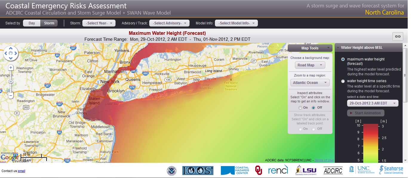
Image

Here's the map for the East Coast - look at St. John's Canada!!!
Image

These are screen shots from my computer at about 11:30 UTC October 29, 2012.

EDIT: Ok, wxman57 informs me the color scale has changed since yesterday. That's good news. That means the surge forecast is not necessarily more severe. However anyway you look at it, a huge swath of the East Coast is now due for 10 foot+ storm surge. That's STILL life-threatening in many areas, I would think.
Last edited by KBBOCA on Mon Oct 29, 2012 7:46 am, edited 1 time in total.
0 likes   

Terry
S2K Supporter
S2K Supporter
Posts: 1450
Joined: Wed Aug 11, 2004 8:25 pm
Location: Lakeland and Anna Maria Island, FL
Contact:

Re:

#2590 Postby Terry » Mon Oct 29, 2012 7:04 am

I've been watching that since yesterday. There is definitely more over-topping of the dunes this morning.

Crostorm wrote:Sea Ranch Resort Webcam in Kill Devil Hills, NC

http://www.visitob.com/webcams/sea-ranc ... vil-hills/
0 likes   

fashionella
Tropical Wave
Tropical Wave
Posts: 1
Joined: Mon Oct 29, 2012 7:00 am

Re: ATL: SANDY - Hurricane - Discussion

#2591 Postby fashionella » Mon Oct 29, 2012 7:08 am

I finally got an account thanks to all for posting all the great info. I thought you would be interested in this link, I wanted to see where those cruiseships ended up...you can also check off "wind" and see those values


http://www.marinetraffic.com/ais/defaul ... level0=100
0 likes   

KBBOCA
S2K Supporter
S2K Supporter
Posts: 1559
Joined: Fri Sep 05, 2003 5:27 am
Location: Formerly Boca Raton, often West Africa. Currently Charlotte NC

#2592 Postby KBBOCA » Mon Oct 29, 2012 7:10 am

Sorry, I should have included the link to the CERA website. It's here:
http://nc-cera.renci.org/cgi-cera-nc/cera-nc.cgi

It's an amazingly useful site, except for the fact that right now it is terrifying me..., I've got so many friends and family in harm's way. Thankfully, most are taking this seriously.
0 likes   

User avatar
tomboudreau
Category 5
Category 5
Posts: 1869
Age: 48
Joined: Tue Feb 18, 2003 6:07 pm
Location: Carnegie, PA
Contact:

#2593 Postby tomboudreau » Mon Oct 29, 2012 7:13 am

Spoke to my brother on LI. Both him and his wife employeers did not close today. She went to work. He is debating on what to do. They both live less then 5 minutes from their offices. He is seriously considering to staying home today and tomorrow. They finished up their precautions on Saturday and have been waiting for the shoe to fall as he put it to me this morning.
0 likes   

BobHarlem
Category 5
Category 5
Posts: 2123
Joined: Thu Oct 20, 2005 6:11 pm

Re: ATL: SANDY - Hurricane - Discussion

#2594 Postby BobHarlem » Mon Oct 29, 2012 7:14 am

This is a live cam from Ocean City, MD. Fager's island (the bay side of Ocean City) which is showing flooding.
0 likes   

User avatar
wxman57
Moderator-Pro Met
Moderator-Pro Met
Posts: 22980
Age: 67
Joined: Sat Jun 21, 2003 8:06 pm
Location: Houston, TX (southwest)

Re:

#2595 Postby wxman57 » Mon Oct 29, 2012 7:16 am

KBBOCA wrote:Oh NO! I just checked out CERA for the latest storm surge maps and my hands are literally shaking. They have gotten so much worse.

Here's the map for NY Metro area:
http://anglicanprayer.files.wordpress.c ... c-nyc1.png

Here's the map for the East Coast - look at St. John's Canada!!!
http://anglicanprayer.files.wordpress.c ... -coast.png

These are screen shots from my computer at about 11:30 UTC October 29, 2012.


Note that they changed the color for the upper end of the scale. The scale went to 16ft yesterday (red) and only 10ft today. Not much difference from yesterday. In fact, the projected surge for Long Island looks identical to yesterday, just a different color today.
0 likes   

tolakram
Admin
Admin
Posts: 20012
Age: 62
Joined: Sun Aug 27, 2006 8:23 pm
Location: Florence, KY (name is Mark)

Re: ATL: SANDY - Hurricane - Discussion

#2596 Postby tolakram » Mon Oct 29, 2012 7:17 am

BobHarlem wrote:This is a live cam from Ocean City, MD. Fager's island (the bay side of Ocean City) which is showing flooding.


Great link. Here's some stills from that link.

Image

Image

Image
0 likes   
M a r k
- - - - -
Join us in chat: Storm2K Chatroom Invite. Android and IOS apps also available.

The posts in this forum are NOT official forecasts and should not be used as such. Posts are NOT endorsed by any professional institution or STORM2K.org. For official information and forecasts, please refer to NHC and NWS products.

clipper35
Tropical Low
Tropical Low
Posts: 38
Joined: Tue Sep 07, 2004 6:09 pm
Location: warwick ri

Re: ATL: SANDY - Hurricane - Discussion

#2597 Postby clipper35 » Mon Oct 29, 2012 7:21 am

well here in southern new england it seems like it was hyped to much this is a typical noreaster for most of us with beach erosion and coastal flooding winds are not bad we have gust to 35 at times but sustained at 23/26 as far as tropical storm strength winds i doubt we will see them up here as big as this storm is the wind field for the tropical storm strength gusts has retracted to 452 miles from 542 last night and most of the tropical storm gusts are in the northwest part in the storm according to nhc recon yes the mid atlantic will get the brunt of this storm, as far as rain most forecasts up here are calling for scattered showers with a 1/2 inch to 1 inch rainfall amounts and yes most of u are saying its still early it will get bad maybe but most of the highways are packed with commuters going into work and most supermarkets and restaurants are open southern new england is seeing a classic noreaster this is typical for this part of the country the storm may be at a all time low pressure and that is historic....
0 likes   

User avatar
Evil Jeremy
S2K Supporter
S2K Supporter
Posts: 5463
Age: 32
Joined: Mon Apr 10, 2006 2:10 pm
Location: Los Angeles, CA

#2598 Postby Evil Jeremy » Mon Oct 29, 2012 7:22 am

Recon just found a decent area of winds that support at least 90mph.

120830 3542N 07203W 6969 02774 9642 +080 +080 289023 025 083 004 01
120900 3541N 07204W 6958 02787 //// +075 //// 277021 025 081 004 01
120930 3540N 07206W 6972 02769 9641 +080 +080 261030 030 084 003 01
121000 3539N 07207W 6964 02785 9643 +090 +090 259030 031 084 003 01
0 likes   
Frances 04 / Jeanne 04 / Katrina 05 / Wilma 05 / Fay 08 / Debby 12 / Andrea 13 / Colin 16 / Hermine 16 / Matthew 16 / Irma 17

User avatar
Weatherguy173
Tropical Storm
Tropical Storm
Posts: 148
Age: 31
Joined: Wed Aug 01, 2012 10:55 pm
Location: Short Hills NJ

#2599 Postby Weatherguy173 » Mon Oct 29, 2012 7:23 am

0 likes   
Nothing I say is intended to be a forecast; it's only food for thought and friendly advice!

User avatar
wxman57
Moderator-Pro Met
Moderator-Pro Met
Posts: 22980
Age: 67
Joined: Sat Jun 21, 2003 8:06 pm
Location: Houston, TX (southwest)

Re: ATL: SANDY - Hurricane - Discussion

#2600 Postby wxman57 » Mon Oct 29, 2012 7:30 am

clipper35 wrote:well here in southern new england it seems like it was hyped to much this is a typical noreaster for most of us with beach erosion and coastal flooding winds are not bad we have gust to 35 at times but sustained at 23/26 as far as tropical storm strength winds i doubt we will see them up here as big as this storm is the wind field for the tropical storm strength gusts has retracted to 452 miles from 542 last night and most of the tropical storm gusts are in the northwest part in the storm according to nhc recon yes the mid atlantic will get the brunt of this storm, as far as rain most forecasts up here are calling for scattered showers with a 1/2 inch to 1 inch rainfall amounts and yes most of u are saying its still early it will get bad maybe but most of the highways are packed with commuters going into work and most supermarkets and restaurants are open southern new england is seeing a classic noreaster this is typical for this part of the country the storm may be at a all time low pressure and that is historic....


Your worst will be tonight/tomorrow, not this morning (if you're in Rhode Island).
0 likes   


Return to “2012”

Who is online

Users browsing this forum: No registered users and 5 guests