000
URNT15 KNHC 241705
AF302 0204A DEBBY3 HDOB 44 20120624
165000 2935N 08503W 8117 01825 //// +154 //// 103036 037 053 004 01
165030 2935N 08506W 8116 01825 //// +151 //// 103036 037 047 002 01
165100 2935N 08508W 8122 01818 //// +132 //// 105037 038 049 005 01
165130 2936N 08510W 8116 01823 //// +135 //// 106042 045 049 004 01
165200 2936N 08512W 8121 01822 //// +139 //// 103045 046 050 005 01
165230 2936N 08514W 8117 01822 //// +135 //// 100044 046 047 006 01
165300 2937N 08517W 8117 01820 //// +123 //// 096048 050 046 007 01
165330 2937N 08519W 8130 01808 //// +134 //// 098048 050 046 007 01
165400 2937N 08521W 8122 01814 //// +135 //// 099046 049 056 008 01
165430 2938N 08524W 8114 01823 //// +139 //// 097048 049 045 004 01
165500 2938N 08526W 8122 01814 //// +142 //// 101050 052 041 004 01
165530 2938N 08528W 8116 01819 //// +148 //// 097050 051 041 003 01
165600 2939N 08531W 8123 01811 //// +139 //// 095052 053 042 005 01
165630 2939N 08533W 8117 01815 //// +140 //// 095053 054 045 006 01
165700 2939N 08535W 8122 01812 //// +128 //// 093054 055 045 006 01
165730 2940N 08538W 8112 01824 //// +129 //// 092053 055 046 007 01
165800 2940N 08540W 8124 01814 //// +122 //// 088048 051 048 013 01
165830 2941N 08542W 8117 01819 //// +115 //// 078045 046 051 017 01
165900 2941N 08545W 8117 01820 //// +107 //// 076046 048 051 016 01
165930 2941N 08547W 8114 01826 //// +114 //// 080049 049 050 015 01
$$
ATL: DEBBY - Post-Tropical
Moderator: S2k Moderators
-
Evil Jeremy

- S2K Supporter

- Posts: 5463
- Age: 32
- Joined: Mon Apr 10, 2006 2:10 pm
- Location: Los Angeles, CA
Re: ATL: DEBBY - Models
So UKMET and CMC join GFDL and GFS in Florida, and the EURO runs within an hour. If it also moves to Florida, I think we might have the biggest track shift yet from the NHC at 5.
0 likes
Frances 04 / Jeanne 04 / Katrina 05 / Wilma 05 / Fay 08 / Debby 12 / Andrea 13 / Colin 16 / Hermine 16 / Matthew 16 / Irma 17

TORNADO WARNING NATIONAL WEATHER SERVICE MIAMI FL 110 PM EDT SUN JUN 24 2012 THE NATIONAL WEATHER SERVICE IN MIAMI HAS ISSUED A * TORNADO WARNING FOR... EAST CENTRAL PALM BEACH COUNTY IN SOUTHEAST FLORIDA... * UNTIL 145 PM EDT * AT 107 PM EDT...NATIONAL WEATHER SERVICE METEOROLOGISTS DETECTED A SEVERE THUNDERSTORM CAPABLE OF PRODUCING A TORNADO NEAR WHISPER WALK...MOVING NORTH AT 25 MPH. * THE TORNADO WILL BE NEAR... LOXAHATCHEE NATIONAL WILDLIFE REFUGE... GREENACRES CITY... VILLAGES OF ORIOLE AND SURROUNDING COMMUNITIES.
0 likes

Re: Re:
loon wrote:brunota2003 wrote:Hm...what if the models are picking up on two different things? What if the upper half of Debby decouples and shoots NE over Florida while leaving behind the LLC of Debby? Wouldn't the LLC then drift/move westward as the ridge builds back in behind the trough? What a forecast nightmare that would create, though.
I forget which model it was but I swear I remember people talking about that exact scenario going happening.
Yes, there was definitely a model that split the two. It was at least a day ago, though. Can't remember which one.
Has that kind of thing ever happened before?
0 likes
-
Jevo

- S2K Supporter
- Posts: 1729
- Age: 47
- Joined: Tue Aug 03, 2004 8:45 pm
- Location: The Flemish Cap
- Contact:
12z HWRF +48

LOL someone broke the HWRF puter its stuck on 48 for the last 10 mins
LOL someone broke the HWRF puter its stuck on 48 for the last 10 mins
0 likes
Disclaimer: 50% of the time I have no clue of what I am talking about. Chances are I am taking a less than educated guess that sounds good because 10 years ago I stole Mike Watkins book 'The Hurricane and its Impact'. For official information please direct yourself to the NHC and their cadre of weather geniuses.
-
Annie Oakley

- Category 5

- Posts: 1103
- Joined: Tue Jul 31, 2007 12:54 pm
- Location: Texas
000
URNT15 KNHC 241708
AF302 0204A DEBBY3 HDOB 45 20120624
170000 2942N 08549W 8121 01818 //// +117 //// 081051 052 052 012 01
170030 2942N 08551W 8114 01828 //// +119 //// 084055 056 052 012 01
170100 2942N 08554W 8123 01819 //// +120 //// 084058 061 051 013 01
170130 2943N 08556W 8116 01830 //// +114 //// 075068 070 050 013 01
170200 2943N 08559W 8120 01823 //// +115 //// 071066 068 047 015 01
170230 2943N 08601W 8122 01823 //// +110 //// 064068 069 045 012 01
170300 2944N 08603W 8117 01831 //// +125 //// 057072 073 043 010 01
170330 2944N 08606W 8124 01825 //// +115 //// 058072 073 040 008 01
170400 2944N 08608W 8121 01832 //// +117 //// 057074 075 040 008 01
170430 2945N 08610W 8120 01832 //// +119 //// 056076 077 040 006 05
170500 2944N 08612W 8114 01839 //// +112 //// 053077 078 /// /// 05
170530 2943N 08613W 8119 01832 //// +114 //// 052076 077 038 008 01
170600 2941N 08613W 8118 01830 //// +103 //// 051076 077 041 010 01
170630 2939N 08613W 8116 01830 //// +103 //// 050072 076 042 010 01
170700 2937N 08613W 8122 01823 //// +112 //// 054065 070 042 013 01
170730 2935N 08613W 8117 01824 //// +116 //// 063061 065 046 012 01
170800 2933N 08613W 8114 01824 //// +118 //// 064061 063 049 015 01
170830 2931N 08612W 8114 01819 //// +120 //// 066056 062 052 015 01
170900 2930N 08612W 8124 01807 //// +120 //// 059049 053 051 009 01
170930 2928N 08612W 8122 01808 //// +128 //// 059043 048 050 008 01
$$
0 likes
FLC099-241730-
/O.CON.KMFL.TO.W.0027.000000T0000Z-120624T1730Z/
PALM BEACH FL-
111 PM EDT SUN JUN 24 2012
...A TORNADO WARNING REMAINS IN EFFECT UNTIL 130 PM EDT FOR
NORTHEASTERN PALM BEACH COUNTY...
AT 110 PM EDT...WEATHER SERVICE DOPPLER RADAR CONTINUED TO INDICATE A
SEVERE THUNDERSTORM CAPABLE OF PRODUCING A TORNADO. THIS STORM WAS
LOCATED NEAR MANGONIA PARK...MOVING NORTH AT 20 MPH.
THE STORM WILL BE NEAR...
MANGONIA PARK...
PORT OF PALM BEACH...
NORTH PALM BEACH...
AND SURROUNDING COMMUNITIES.
0 likes
-
PTrackerLA

- Category 5
- Posts: 5281
- Age: 42
- Joined: Thu Oct 10, 2002 8:40 pm
- Location: Lafayette, LA
Re: ATL: DEBBY - Models
Looks like HWRF is the only 12z model so far with a westward movement.
0 likes
-
Jevo
- S2K Supporter
- Posts: 1729
- Age: 47
- Joined: Tue Aug 03, 2004 8:45 pm
- Location: The Flemish Cap
- Contact:
Re:
PTrackerLA wrote:Where do you get those HWRF images?
http://raleighwx.americanwx.com/models/gfdl.html
0 likes
Disclaimer: 50% of the time I have no clue of what I am talking about. Chances are I am taking a less than educated guess that sounds good because 10 years ago I stole Mike Watkins book 'The Hurricane and its Impact'. For official information please direct yourself to the NHC and their cadre of weather geniuses.


-
USTropics
- Professional-Met

- Posts: 2738
- Joined: Sun Aug 12, 2007 3:45 am
- Location: Florida State University
Re: ATL: DEBBY - Models
If memory serves correctly both the GFS and the ECMWF had various runs that split the energy, moving a portion towards Florida and the other portion towards the BOC. I believe even 5-7 days ago there were a few runs showing the split energy scenario.
0 likes
Re: ATL: DEBBY - Tropical Storm - Discussion
Gov. Jindal declares state of emergency for LA ahead of TS Debbie. (WWL website)
0 likes
-
tolakram
- Admin

- Posts: 20180
- Age: 62
- Joined: Sun Aug 27, 2006 8:23 pm
- Location: Florence, KY (name is Mark)
Re: ATL: DEBBY - Tropical Storm - Discussion
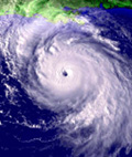
Latest Visible:

0 likes
M a r k
- - - - -
Join us in chat: Storm2K Chatroom Invite. Android and IOS apps also available.
The posts in this forum are NOT official forecasts and should not be used as such. Posts are NOT endorsed by any professional institution or STORM2K.org. For official information and forecasts, please refer to NHC and NWS products.
-
vbhoutex

- Storm2k Executive
- Posts: 29146
- Age: 74
- Joined: Wed Oct 09, 2002 11:31 pm
- Location: Cypress, TX
- Contact:
Re:
PTrackerLA wrote:Really hard to envision a westward movement now. Debby can't even get a cloud into Louisiana today and we are baking under this high pressure.
This is definitely going to be interesting to watch. Here in Houston we are already at 93f with a very obvious W-SW wind which is bringing in our heat and shows how strong the ridge is in our area and yes we are cloudless also. I am starting to think the ridge is stronger than expected and it doesn't appear that the ULL is moving much either. Those two factors tend to point towards a more Northerly component for Debby's track. I am not ready to throw out a possible Westward move, but with her further N than expected it also makes it more likely she will feel the incoming trough. Time will tell. Even Dr. Bill Read, who is now a consultant on Channel 2 here in Houston, said this morning that Debby is really a tough one to forecast.
0 likes
Skywarn, C.E.R.T.
Please click below to donate to STORM2K to help with the expenses of keeping the site going:

Please click below to donate to STORM2K to help with the expenses of keeping the site going:
-
Hurricane Andrew

- S2K Supporter
- Posts: 1891
- Age: 27
- Joined: Sun May 23, 2010 2:53 pm
- Location: KS
-
brunota2003

- S2K Supporter
- Posts: 9476
- Age: 35
- Joined: Sat Jul 30, 2005 9:56 pm
- Location: Stanton, KY...formerly Havelock, NC
- Contact:
-
StormTracker

- S2K Supporter
- Posts: 2909
- Age: 59
- Joined: Thu Jun 29, 2006 6:06 am
- Location: Quail Heights(Redlands), FL.
Re: ATL: DEBBY - Models
This is what I love about tracking storms! Just when we think we've got it down pat, Mother Nature comes along and says: guys & gyrlz, you still have a lot to learn!!!
0 likes
Something's wrong when you regret, things that haven't happened yet!

-
cycloneye

- Admin
- Posts: 149319
- Age: 69
- Joined: Thu Oct 10, 2002 10:54 am
- Location: San Juan, Puerto Rico
Re: ATL: DEBBY - Recon Discussion
Good one!! at flight level.
From 53° at 77 knots
(From the NE at ~ 88.5 mph)
From 53° at 77 knots
(From the NE at ~ 88.5 mph)
0 likes
Visit the Caribbean-Central America Weather Thread where you can find at first post web cams,radars
and observations from Caribbean basin members Click Here
and observations from Caribbean basin members Click Here

Re: ATL: DEBBY - Models
USTropics wrote:If memory serves correctly both the GFS and the ECMWF had various runs that split the energy, moving a portion towards Florida and the other portion towards the BOC. I believe even 5-7 days ago there were a few runs showing the split energy scenario.
NOGAPS had a run with a split yesterday, but none of the other models have shown it lately.
0 likes
Who is online
Users browsing this forum: No registered users and 18 guests