
WPAC: BOPHA - Remnants
Moderator: S2k Moderators
-
supercane4867
- Category 5

- Posts: 4966
- Joined: Wed Nov 14, 2012 10:43 am
Re: WPAC: BOPHA - Typhoon
I think Bopha may have just peaked, its CDO warmed and the eye become asymmetrical in the past hours, correct me if I'm wrong.
0 likes


-
supercane4867
- Category 5
- Posts: 4966
- Joined: Wed Nov 14, 2012 10:43 am
Re: WPAC: BOPHA - Typhoon
Bopha's intensification phrase reminds me of Typhoon Tembin, which was able to intensify rapidly due to small size and compact structure, but its convection waned and eye became cloudfilled as outflow decreased. However Tembin did't have the dry air and low latitude problem that Bopha has to face.
0 likes
-
euro6208


-
dexterlabio
- Category 5
- Posts: 3503
- Joined: Sat Oct 24, 2009 11:50 pm
Re: WPAC: BOPHA - Typhoon
the eye is definitely having some issues IMO. but i don't think it's too bad that it's going all the way down at this point. still has a long time to go before it hits the dry air and the landmass itself. the RI phase may have already ended but it doesn't mean it wouldn't get another bout of intensification along the way. Shear remains "friendly" near the area. though if it were then good news for Mindanao in terms of the winds...but still no good in terms of rainfall...
0 likes
Personal Forecast Disclaimer:
The posts in this forum are NOT official forecast and should not be used as such. They are just the opinion of the poster and may or may not be backed by sound meteorological data. They are NOT endorsed by any professional institution or storm2k.org. For official information, please refer to the NHC and NWS products.
The posts in this forum are NOT official forecast and should not be used as such. They are just the opinion of the poster and may or may not be backed by sound meteorological data. They are NOT endorsed by any professional institution or storm2k.org. For official information, please refer to the NHC and NWS products.
-
supercane4867
- Category 5
- Posts: 4966
- Joined: Wed Nov 14, 2012 10:43 am
Re: WPAC: BOPHA - Typhoon
euro6208 wrote:her eye is super small!
160 knots is likely a reality!
Calm down...she's not in anywere close of being 160kts
0 likes
-
RobWESTPACWX
- WestPACMet

- Posts: 1616
- Joined: Fri Sep 17, 2010 2:26 am
- Location: Tokyo, Japan
- Contact:
Re: WPAC: BOPHA - Typhoon
Hey everyone, I just made a video with my latest information. But I always appreciate feedback and I know Im in and out of here but still lurking in the corner most of the day.
[youtube]http://www.youtube.com/watch?v=Buqq50bRShQ[/youtube]
[youtube]http://www.youtube.com/watch?v=Buqq50bRShQ[/youtube]
0 likes
Satellites, Charts and Forecasting tools for East Asia at WESTERNPACIFICWEATHER.COM
-
RobWESTPACWX
- WestPACMet
- Posts: 1616
- Joined: Fri Sep 17, 2010 2:26 am
- Location: Tokyo, Japan
- Contact:
Re: WPAC: BOPHA - Typhoon
Crostorm wrote:

Look at all those snow clouds hitting Northern Japan. Such a contradiction Snow in the north and typhoon in the south.
0 likes
Satellites, Charts and Forecasting tools for East Asia at WESTERNPACIFICWEATHER.COM
-
ozonepete
- Professional-Met

- Posts: 4743
- Joined: Mon Sep 07, 2009 3:23 pm
- Location: From Ozone Park, NYC / Now in Brooklyn, NY
Re: WPAC: BOPHA - Typhoon
Bopha has undergone some pretty significant weakening and it looks like a lot of it was due to DMIN. But it's already starting to ramp up again and I would think that as night comes in a few hours (around 1200 UTC or 8AM EDT our time) it will start to really ramp up again as it heads towards DMAX. Since there really aren't any negatives right now I still think super typhoon is pretty likely.
0 likes
-
dexterlabio
- Category 5
- Posts: 3503
- Joined: Sat Oct 24, 2009 11:50 pm
Re: WPAC: BOPHA - Typhoon
yes the eye is kinda clearing out again though it still looks somewhat contracted...and still is some 4 days away.. I'm thinking about how people in the south will cope up if this current track continues.. It will be better if the typhoon all happens at daylight, in contrast of what happened during Washi when the worst of the flood and rains came late night...
0 likes
Personal Forecast Disclaimer:
The posts in this forum are NOT official forecast and should not be used as such. They are just the opinion of the poster and may or may not be backed by sound meteorological data. They are NOT endorsed by any professional institution or storm2k.org. For official information, please refer to the NHC and NWS products.
The posts in this forum are NOT official forecast and should not be used as such. They are just the opinion of the poster and may or may not be backed by sound meteorological data. They are NOT endorsed by any professional institution or storm2k.org. For official information, please refer to the NHC and NWS products.
-
supercane4867
- Category 5
- Posts: 4966
- Joined: Wed Nov 14, 2012 10:43 am
Re: WPAC: BOPHA - Typhoon
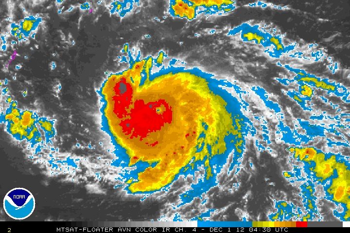
T# went down to 5.5
DATE TIME LAT LON CLASSIFICATION ID NAME
20121201 0230 4.9 -141.6 T5.5/6.0 26W BOPHA
TXPQ27 KNES 010314
TCSWNP
A. 26W (BOPHA)
B. 01/0230Z
C. 4.9N
D. 141.6E
E. ONE/MTSAT
F. T5.5/6.0/W0.5/06HRSG. IR/EIR/VIS
H. REMARKS...OW EYE IS EMBEDDED IN LG AND SURROUNDED BY W RESUTLING
DATE TIME LAT LON CLASSIFICATION ID NAME
20121201 0230 4.9 -141.6 T5.5/6.0 26W BOPHA
TXPQ27 KNES 010314
TCSWNP
A. 26W (BOPHA)
B. 01/0230Z
C. 4.9N
D. 141.6E
E. ONE/MTSAT
F. T5.5/6.0/W0.5/06HRSG. IR/EIR/VIS
H. REMARKS...OW EYE IS EMBEDDED IN LG AND SURROUNDED BY W RESUTLING
0 likes
-
Meow
People in Palau don’t believe what is going to happen.
http://www.oceaniatv.net/2012/12/01/typ ... r-palau-2/
Typhoon Bopha Update — Eerie Calm Over Palau
Posted on December 1, 2012 by Oceania TV News
Palau is dead still right now, with almost an eerie calmness. It belies the impending typhoon disaster that seems to be tracking its way directly for Palau. Any tropical cyclone approaching within 180 miles of Koror is considered a threat to Palau. The latest information has Typhoon Bopha approaching within 15 miles of Koror. In its steady approach, Typhoon Bopha is gaining strength and is expected to reach Palau late Sunday evening with sustained winds of 125 miles per hour and gusts up to 155 miles per hour. This will be the most powerful storm Palau has experienced since before 1941.
Typhoon Bopha is projected to land in mid-Babeldoab with major impact to Palau’s city center Koror. Some businesses and households are beginning to prepare; however, there seems to be a general sense of disbelief that the storm is coming and how powerful it will be when it arrives. Driving through the downtown city center only three or four businesses have boarded up their windows. Some locals have explained that “it always turns north” representing a general distrust in the meterological predictions for Typhoon Bopha.
Palau is an island nation with no building codes. A large majority of homes are built with wood frames and tin roofs. The potential for wide spread destruction is unfathomable. Residents of Palau’s northern state of Kayangel, a low lying atoll, have refused to evacuate and the government is not imposing a mandatory evacuation. The last large storm to hit Palau was Typhoon Marie in 1976 with peak gusts of of 86 mph. However, no severe storm has has ever been recorded as effecting Palau. Typhoon Sally had recorded winds of only 89 miles in 1967. Typhoon Sally in 1967 caused wide spread destruction.
0 likes
-
supercane4867
- Category 5
- Posts: 4966
- Joined: Wed Nov 14, 2012 10:43 am

-
ozonepete
- Professional-Met
- Posts: 4743
- Joined: Mon Sep 07, 2009 3:23 pm
- Location: From Ozone Park, NYC / Now in Brooklyn, NY
Re: WPAC: BOPHA - Typhoon
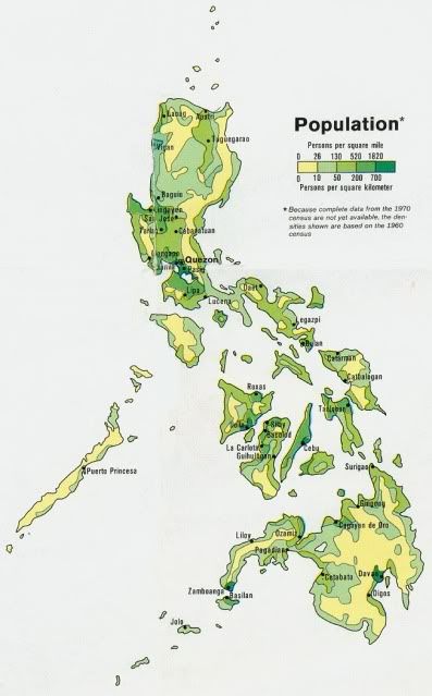
cycloneye wrote:Does anyone has a map of the Phillippines to see where Mindanao is located? I really hope those folks are starting preparations.
Hi Luis, here's the population map (an old map but the density distribution is still similar today) and a topographic map with Mindanao annotated.

Last edited by ozonepete on Sat Dec 01, 2012 2:53 am, edited 1 time in total.
0 likes
-
Meow
Re: WPAC: BOPHA - Typhoon
ozonepete wrote:Hi Luis, here's the population map (an old map but the density distribution is still similar today) and a topographic map with Mindanao annotated.
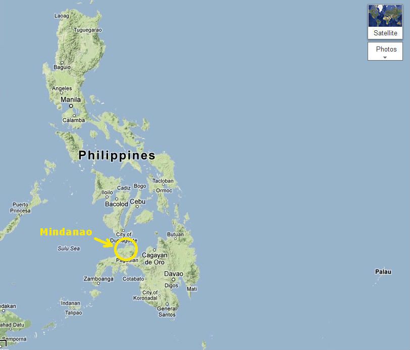
That is incorrect. The whole large island itself is actually Mindanao.
0 likes
-
stormstrike
- Tropical Storm

- Posts: 159
- Joined: Thu Nov 29, 2012 12:37 am
Re: WPAC: BOPHA - Typhoon
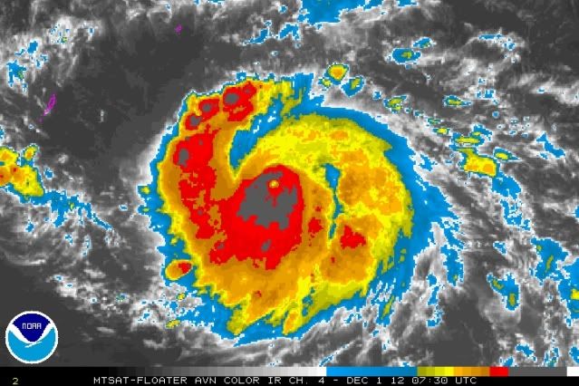
is Bopha undergoing an Eyewall Replacement Cycle? her eye seems to be choked...

0 likes
-
dexterlabio
- Category 5
- Posts: 3503
- Joined: Sat Oct 24, 2009 11:50 pm
Re: WPAC: BOPHA - Typhoon
^it definitely is, but I have a feeling it would be brief. Cloud tops are cooling again near the contracted eye...and JTWC actually expects this to strengthen to supertyphoon near Palau on their latest warning.

0 likes
Personal Forecast Disclaimer:
The posts in this forum are NOT official forecast and should not be used as such. They are just the opinion of the poster and may or may not be backed by sound meteorological data. They are NOT endorsed by any professional institution or storm2k.org. For official information, please refer to the NHC and NWS products.
The posts in this forum are NOT official forecast and should not be used as such. They are just the opinion of the poster and may or may not be backed by sound meteorological data. They are NOT endorsed by any professional institution or storm2k.org. For official information, please refer to the NHC and NWS products.
-
ozonepete
- Professional-Met
- Posts: 4743
- Joined: Mon Sep 07, 2009 3:23 pm
- Location: From Ozone Park, NYC / Now in Brooklyn, NY
Re: WPAC: BOPHA - Typhoon
Ok, here we go. Another significant strengthening phase seems to be starting. And although the weakening sunlight is probably helping for the thunderstorm tops to cool again and thus aiding this flare-up of taller thunderstorms near the core, just wait until the sun is fully down - the core convection should really deepen. Also notice how the overall circulation envelope has really expanded. This is now getting to be a much larger cyclone.
0 likes
-
Crostorm

- Category 5
- Posts: 2060
- Age: 51
- Joined: Mon Dec 25, 2006 3:51 pm
- Location: Croatia-Europe
- Contact:
Here is an abstract from Typhoon Vamei
Since tropical cyclone observations started in 1886 in the North Atlantics and 1945 in the western North Pacific, the previous recorded lowest latitude for a typhoon was 3.3°N for Typhoon Sarah in 1956 (Fortner, 1958). Vamei formed near Singapore on 0600 UTC 27 December 2001. With its circulation center at 1.5°N and a radius of convective cloud area of near 200 km (Fig. 1a), the storm circulation was on both sides of the equator. Naval ships reported maximum sustained surface wind of 39 m s-1 and gust wind of up to 54 m s-1 (Joint Typhoon Warning Center, 2002), which caused damages to the carrier USS Carl Vinson and an accompanying ship. This was the first-ever recorded tropical cyclone formation at such equatorial latitude.
http://www.weather.nps.navy.mil/cpchang ... /vamei.htm
0 likes
Who is online
Users browsing this forum: No registered users and 91 guests