ATL: ISAAC - Post-Tropical - Discussion
Moderator: S2k Moderators
Re: ATL: ISAAC - Tropical Storm - Discussion
The outflow and strengthening could be showing signs of a stronger storm more vulnerable to the steering currents that will cause the turn.
0 likes
-
SouthFLTropics

- Category 5

- Posts: 4258
- Age: 50
- Joined: Thu Aug 14, 2003 8:04 am
- Location: Port St. Lucie, Florida
Re: ATL: ISAAC - Tropical Storm - Discussion
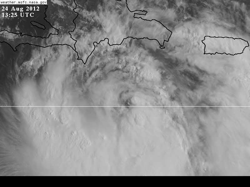
I think that once this gets north of the big islands there is potential for a big strengthening period. If you look at the outflow fanning across the Bahamas this morning I believe that it is indicative of much better conditions for Isaac.
On another note...I noticed a lot of people not trusting the NHC on this one. I'll go on record that the NHC is way more correct than not most of the time. If I had to make my bed I would want the NHC in my corner for sure. Their is only one time that I can recall that a forecast was a major bust for them and that was during Mitch in 1998. And let's face it, no forecaster or computer model is perfect and they aren't going to be right 100% of the time. But once again, I'd dare say that the NHC track record is pretty darn good.
SFT
0 likes
Fourth Generation Florida Native
Personal Storm History: David 79, Andrew 92, Erin 95, Floyd 99, Irene 99, Frances 04, Jeanne 04, Wilma 05, Matthew 16, Irma 17, Ian 22, Nicole 22, Milton 24
Personal Storm History: David 79, Andrew 92, Erin 95, Floyd 99, Irene 99, Frances 04, Jeanne 04, Wilma 05, Matthew 16, Irma 17, Ian 22, Nicole 22, Milton 24
-
wxman57

- Moderator-Pro Met

- Posts: 23171
- Age: 68
- Joined: Sat Jun 21, 2003 8:06 pm
- Location: Houston, TX (southwest)
Re: ATL: ISAAC - Tropical Storm - Discussion
Snowman67 wrote:wxman57 wrote:It's going to have to take a sharp right turn to hit Haiti. Center is well south of the 06Z model tracks.
Wxman57 - do you think it will track closer to Jamaica than Haiti? If so, do you feel that this would change its eventual U.S. projected landfall location? Thanks.
I think it'll eventually head for the same weakness in the ridge even passing south of Haiti (or even over Jamaica). I've been thinking western FL Panhandle (Pensacola to Panama City). That's my best estimate for now, but I'm not ruling out a shift west toward SE LA. I think the 12Z models are too far east, as they have Isaac making a sharp right turn from hour zero.
0 likes
-
nativefloridian

- Tropical Storm

- Posts: 172
- Joined: Tue Aug 21, 2012 2:48 pm
- Location: Pembroke Pines, FL
Good Morning All....been an avid bystander reading all the interesting posts and points of view. I finally have a chance now to participate in the discussions. As far as Isaac....I'm playing the wait and see game right now. He's certainly been quite deceiving at times. I was born in Miami and still reside in South Florida (Broward County) so I've been through many storms since the 1950's. Glad to finally be on board here 
0 likes
-
Hurricane Andrew

- S2K Supporter

- Posts: 1891
- Age: 27
- Joined: Sun May 23, 2010 2:53 pm
- Location: KS

Re:
nativefloridian wrote:Good Morning All....been an avid bystander reading all the interesting posts and points of view. I finally have a chance now to participate in the discussions. As far as Isaac....I'm playing the wait and see game right now. He's certainly been quite deceiving at times. I was born in Miami and still reside in South Florida (Broward County) so I've been through many storms since the 1950's. Glad to finally be on board here
Welcome nativefloridian! Good to have you on here. I, too, have been around since the 1950's here in Louisiana and have weathered many hurricanes as well. The wait and see game is the best that we can do at the moment.
0 likes

Re:
nativefloridian wrote:Good Morning All....been an avid bystander reading all the interesting posts and points of view. I finally have a chance now to participate in the discussions. As far as Isaac....I'm playing the wait and see game right now. He's certainly been quite deceiving at times. I was born in Miami and still reside in South Florida (Broward County) so I've been through many storms since the 1950's. Glad to finally be on board here
welcome! Glad you joined us!
0 likes
-
ozonepete
- Professional-Met

- Posts: 4743
- Joined: Mon Sep 07, 2009 3:23 pm
- Location: From Ozone Park, NYC / Now in Brooklyn, NY
Re:
nativefloridian wrote:Good Morning All....been an avid bystander reading all the interesting posts and points of view. I finally have a chance now to participate in the discussions. As far as Isaac....I'm playing the wait and see game right now. He's certainly been quite deceiving at times. I was born in Miami and still reside in South Florida (Broward County) so I've been through many storms since the 1950's. Glad to finally be on board here
Welcome!
0 likes
-
cycloneye

- Admin

- Posts: 149224
- Age: 69
- Joined: Thu Oct 10, 2002 10:54 am
- Location: San Juan, Puerto Rico
Re: ATL: ISAAC - Tropical Storm - Discussion
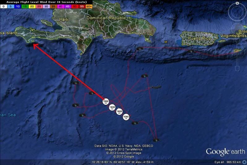
12z Best Track has been updated up to 50kts
AL, 09, 2012082412, , BEST, 0, 159N, 704W, 50, 1000, TS
ftp://ftp.nhc.noaa.gov/atcf/tcweb/inves ... 012.invest
AL, 09, 2012082412, , BEST, 0, 159N, 704W, 50, 1000, TS
ftp://ftp.nhc.noaa.gov/atcf/tcweb/inves ... 012.invest
0 likes
Visit the Caribbean-Central America Weather Thread where you can find at first post web cams,radars
and observations from Caribbean basin members Click Here
and observations from Caribbean basin members Click Here
-
Deputy Van Halen
- Tropical Storm
- Posts: 104
- Joined: Thu Aug 03, 2006 12:00 am
- Location: Texas City, TX
Re: ATL: ISAAC - Tropical Storm - Discussion
Am I recalling correctly that the width of the NHC's cone is standardized, and not based on the uncertainty about the particular storm in question? So if they're really scratching their heads about where Isaac will be 5 days from now, they won't make the cone wider to reflect that?
0 likes
-
tolakram
- Admin
- Posts: 20176
- Age: 62
- Joined: Sun Aug 27, 2006 8:23 pm
- Location: Florence, KY (name is Mark)
Re: ATL: ISAAC - Tropical Storm - Discussion
Deputy Van Halen wrote:Am I recalling correctly that the width of the NHC's cone is standardized, and not based on the uncertainty about the particular storm in question? So if they're really scratching their heads about where Isaac will be 5 days from now, they won't make the cone wider to reflect that?
Correct. Always the same per time point based on past performance. In 2012 the cone is a little smaller than 2011 ... looking for the reference on this.
http://www.nhc.noaa.gov/aboutcone.shtml
2012 product changes: http://www.nhc.noaa.gov/news/20120403_p ... hanges.pdf
0 likes
M a r k
- - - - -
Join us in chat: Storm2K Chatroom Invite. Android and IOS apps also available.
The posts in this forum are NOT official forecasts and should not be used as such. Posts are NOT endorsed by any professional institution or STORM2K.org. For official information and forecasts, please refer to NHC and NWS products.
-
Air Force Met
- Military Met

- Posts: 4372
- Age: 57
- Joined: Tue Jul 08, 2003 9:30 am
- Location: Roan Mountain, TN
Re: ATL: ISAAC - Tropical Storm - Discussion
Deputy Van Halen wrote:Am I recalling correctly that the width of the NHC's cone is standardized, and not based on the uncertainty about the particular storm in question? So if they're really scratching their heads about where Isaac will be 5 days from now, they won't make the cone wider to reflect that?
Correct. It is an error rate displaying a 2/3rds chance the storm will stay within that error circle in a given forecast point (24, 48, 72, etc). The cone is made by drawing lines around the edges of the circles.
The cone has nothing to do with uncertainty or any other input. It's pure stats.
EDIT: And an important thing to remember is - 1/3 of the time the tracks fall OUTSIDE the cone at any given point.
And yes, Cyclone, circles were reduced. Error rates went down so stats decreased the circles.
0 likes
-
HurricaneAndrew92
Re: ATL: ISAAC - Tropical Storm - Discussion
Saw peak Winds at FL are 75mph about, winds below are 65mph?
0 likes

-
Air Force Met
- Military Met
- Posts: 4372
- Age: 57
- Joined: Tue Jul 08, 2003 9:30 am
- Location: Roan Mountain, TN
Re: Re:
wxman57 wrote:Hurricane Andrew wrote:WX57, what strength do you figure for landfall? Final LF. That is.
Somewhere between 60 and 120 mph, I'm thinking.
Wow...what a commitment. You could work for the government (says the government employee)...
0 likes
-
Stormcenter
- S2K Supporter
- Posts: 6689
- Joined: Wed Sep 03, 2003 11:27 am
- Location: Houston, TX
Re: Re:
I guess that means you're really not sure huh?
wxman57 wrote:Hurricane Andrew wrote:WX57, what strength do you figure for landfall? Final LF. That is.
Somewhere between 60 and 120 mph, I'm thinking.
0 likes
-
Weatherboy1

- Category 5
- Posts: 1190
- Age: 50
- Joined: Mon Jul 05, 2004 1:50 pm
- Location: Jupiter/Sarasota, FL
Well it looks like Isaac is FINALLY intensifying given the latest recon trends. Recon also showing more WNW/NW motion in recent center fixes. That weakness over FL is pretty pronounced if you look at steering current maps, the water vapor imagery, and so on. So a fairly sharp turn to the NW is likely, in my opinion. I am very interested to see what today's midday models look like. We swung pretty far west yesterday and appear to be inching back to the east this morning, possibly as a result of the NOAA synoptic mission. Does that trend stick? These are very important questions to get answers to here in South FL as any further nudge east puts east coast FL in nastier conditions. For the record, I do NOT expect a direct hit here. But I am somewhat more concerned about potential impacts in terms of wind/rain this morning.
Just my opinion, as an amateur, as always.
Just my opinion, as an amateur, as always.
0 likes
-
ExBailbonds

- Tropical Storm
- Posts: 142
- Joined: Wed Sep 06, 2006 12:03 am
- Location: Homestead,Fl
- Contact:
Re: ATL: ISAAC - Tropical Storm - Discussion
Air Force Met wrote:Deputy Van Halen wrote:Am I recalling correctly that the width of the NHC's cone is standardized, and not based on the uncertainty about the particular storm in question? So if they're really scratching their heads about where Isaac will be 5 days from now, they won't make the cone wider to reflect that?
Correct. It is an error rate displaying a 2/3rds chance the storm will stay within that error circle in a given forecast point (24, 48, 72, etc). The cone is made by drawing lines around the edges of the circles.
The cone has nothing to do with uncertainty or any other input. It's pure stats.
EDIT: And an important thing to remember is - 1/3 of the time the tracks fall OUTSIDE the cone at any given point.
And yes, Cyclone, circles were reduced. Error rates went down so stats decreased the circles.
one thing that throws alot of people off slower the storm the closer together the circles. So the cone sometimes appears fatter then it is. Fast moving storm long cone. Slow storm short and stubby cone.
0 likes
-
wxman57
- Moderator-Pro Met
- Posts: 23171
- Age: 68
- Joined: Sat Jun 21, 2003 8:06 pm
- Location: Houston, TX (southwest)
Re: ATL: ISAAC - Tropical Storm - Discussion
To add to AFM's post about the cone - in no way does the cone define a storm's possible impact. I heard someone on the radio this morning saying "we're outside the cone so no impact expected". A hurricane can produce hurricane force wind outside the cone even with a perfect forecast. TS/H winds can extend well outside the cone, so don't become complacent if your location is outside the cone.
0 likes
Who is online
Users browsing this forum: No registered users and 4 guests