WPAC: BOPHA - Remnants

Moderator: S2k Moderators

Message
Author
ozonepete
Professional-Met
Professional-Met
Posts: 4743
Joined: Mon Sep 07, 2009 3:23 pm
Location: From Ozone Park, NYC / Now in Brooklyn, NY

Re: WPAC: BOPHA - Typhoon

#321 Postby ozonepete » Sat Dec 01, 2012 3:30 am

stormstrike wrote:is Bopha undergoing an Eyewall Replacement Cycle? her eye seems to be choked...

Image


The eye looks great in that image. It already underwent an ERC hours ago and is now strengthening again.
0 likes   

ozonepete
Professional-Met
Professional-Met
Posts: 4743
Joined: Mon Sep 07, 2009 3:23 pm
Location: From Ozone Park, NYC / Now in Brooklyn, NY

Re: WPAC: BOPHA - Typhoon

#322 Postby ozonepete » Sat Dec 01, 2012 3:59 am

The left side image is from 2230 today and the right from 9 hours later. Look at the expansion in the core size and especially the overall circulation envelope in the last 9 hours. (These images cover the same geographic area.) If the core of Bopha can regain the same symmetry (pure round shape) that it had in the left side image while maintaining its new larger size, this will make super typhoon status easily in the next 24 hours or so.

Image
0 likes   

ozonepete
Professional-Met
Professional-Met
Posts: 4743
Joined: Mon Sep 07, 2009 3:23 pm
Location: From Ozone Park, NYC / Now in Brooklyn, NY

Re: WPAC: BOPHA - Typhoon

#323 Postby ozonepete » Sat Dec 01, 2012 4:34 am

This storm is on hyper-drive. It's already formed a new ring of very deep convection around the center (black circle around the eye). Very interesating Tropical cyclone, especially because of it's strength so close to the equator.

Image
0 likes   

stormstrike
Tropical Storm
Tropical Storm
Posts: 159
Joined: Thu Nov 29, 2012 12:37 am

Re: WPAC: BOPHA - Typhoon

#324 Postby stormstrike » Sat Dec 01, 2012 4:36 am

ozonepete wrote:The left side image is from 2230 today and the right from 9 hours later. Look at the expansion in the core size and especially the overall circulation envelope in the last 9 hours. (These images cover the same geographic area.) If the core of Bopha can regain the same symmetry (pure round shape) that it had in the left side image while maintaining its new larger size, this will make super typhoon status easily in the next 24 hours or so.

Image


yet, the left side looks healthier and more impressive... :eek: i wonder if Bopha would recover its elegance because ryt now it does look squashed.. :lol:
0 likes   

ozonepete
Professional-Met
Professional-Met
Posts: 4743
Joined: Mon Sep 07, 2009 3:23 pm
Location: From Ozone Park, NYC / Now in Brooklyn, NY

Re: WPAC: BOPHA - Typhoon

#325 Postby ozonepete » Sat Dec 01, 2012 4:58 am

:uarrow: Ha, you will see. Growing pains.
0 likes   

dexterlabio
Category 5
Category 5
Posts: 3466
Joined: Sat Oct 24, 2009 11:50 pm

Re: WPAC: BOPHA - Typhoon

#326 Postby dexterlabio » Sat Dec 01, 2012 5:30 am

the left picture is sure impressive but the right one has potential with those large areas of deeper convection. it looks like the ring of deep convection is wrapping into the choked eye and once it's done, it's an all-new monster again. to explain the weakening trend that happened, I agree with ozonepete about DMIN, and the other reason could be the brief round of eyewall replacement that's happening now.
0 likes   
Personal Forecast Disclaimer:
The posts in this forum are NOT official forecast and should not be used as such. They are just the opinion of the poster and may or may not be backed by sound meteorological data. They are NOT endorsed by any professional institution or storm2k.org. For official information, please refer to the NHC and NWS products.

User avatar
mrbagyo
Category 5
Category 5
Posts: 3711
Age: 32
Joined: Thu Apr 12, 2012 9:18 am
Location: 14.13N 120.98E
Contact:

Re: WPAC: BOPHA - Typhoon

#327 Postby mrbagyo » Sat Dec 01, 2012 5:39 am

just attended my Saturday class in Manila, and now, holly cow. what is that, that caught me by surprise..latest models are showing a passage in visayas, then moving up in west coast of Luzon , jeez... that is really scary

I hope it wont follow the track of tropical storm Dot of 1979
Image

dexterlabio wrote:i wonder who's the last TC to become super at such low latitude. at this rate, i now think she has a good chance to be a Cat5 soon.

Look at my avatar, that's super typhoon mike of 1990 peaked at 285 kph 885 hpa according to JTWC, but that is higher in latitude compared to BOPHA, lets see what will happen when its done with Palau

from FEMA:
"Palau Typhoon Mike (DR-882)
Incident period: Saturday, November 10, 1990 to Sunday, November 11, 1990
Major Disaster Declaration declared on November 28, 1990"
0 likes   
The posts in this forum are NOT official forecast and should not be used as such. They are just the opinion of the poster and may or may not be backed by sound meteorological data. They are NOT endorsed by any professional institution or storm2k.org. For official information, please refer to RSMC, NHC and NWS products.

User avatar
wxmann_91
Category 5
Category 5
Posts: 8013
Age: 33
Joined: Fri Jul 15, 2005 2:49 pm
Location: Southern California
Contact:

#328 Postby wxmann_91 » Sat Dec 01, 2012 6:29 am

Microwave data indicates there might be some shear affecting Bopha, which may be delaying completion of the ERC that started earlier today.

http://tropic.ssec.wisc.edu/real-time/m ... 2hr_07.gif

That aside, a good comparison to this storm is STY Kate of 1970, which also became Cat 4 south of 5N latitude:

Image
0 likes   

Meow

#329 Postby Meow » Sat Dec 01, 2012 7:30 am

OMG to Bopha’s convection.

Image
0 likes   

dexterlabio
Category 5
Category 5
Posts: 3466
Joined: Sat Oct 24, 2009 11:50 pm

Re: WPAC: BOPHA - Typhoon

#330 Postby dexterlabio » Sat Dec 01, 2012 7:33 am

A picture of the whole Philippine Area of Responsibility with TY Bopha on the lower right corner...also shows the EWRC almost done with that thick area of cold cloud tops/deep convection wrapped on the tiny eye.

Image

well things that could be hindering Bopha's development also includes dry air entrainment, lucky for this storm it is only average-sized and not large enough to suck large amounts of dry air.
0 likes   
Personal Forecast Disclaimer:
The posts in this forum are NOT official forecast and should not be used as such. They are just the opinion of the poster and may or may not be backed by sound meteorological data. They are NOT endorsed by any professional institution or storm2k.org. For official information, please refer to the NHC and NWS products.

User avatar
cycloneye
Admin
Admin
Posts: 143879
Age: 68
Joined: Thu Oct 10, 2002 10:54 am
Location: San Juan, Puerto Rico

Re: WPAC: BOPHA - Typhoon

#331 Postby cycloneye » Sat Dec 01, 2012 7:52 am

WTPQ20 RJTD 011200
RSMC TROPICAL CYCLONE ADVISORY
NAME TY 1224 BOPHA (1224)
ANALYSIS
PSTN 011200UTC 05.4N 140.0E GOOD
MOVE WNW 11KT
PRES 945HPA
MXWD 090KT

GUST 130KT
50KT 80NM
30KT 210NM NORTH 180NM SOUTH
FORECAST
24HF 021200UTC 06.5N 135.5E 70NM 70%
MOVE WNW 12KT
PRES 930HPA
MXWD 095KT
GUST 135KT
48HF 031200UTC 07.7N 130.2E 110NM 70%
MOVE WNW 13KT
PRES 930HPA
MXWD 095KT
GUST 135KT
72HF 041200UTC 09.5N 124.9E 160NM 70%
MOVE WNW 14KT
PRES 955HPA
MXWD 075KT
GUST 105KT =
0 likes   
Visit the Caribbean-Central America Weather Thread where you can find at first post web cams,radars
and observations from Caribbean basin members Click Here

stormstrike
Tropical Storm
Tropical Storm
Posts: 159
Joined: Thu Nov 29, 2012 12:37 am

Re: WPAC: BOPHA - Typhoon

#332 Postby stormstrike » Sat Dec 01, 2012 7:54 am

JMA shifts to lower latitude...

Image


almost the same with the GFS model..

Image
0 likes   

User avatar
NDG
S2K Supporter
S2K Supporter
Posts: 15446
Joined: Sun Jul 09, 2006 10:14 pm
Location: Orlando, FL

#333 Postby NDG » Sat Dec 01, 2012 8:29 am

I just noticed the extremely low latitude of this typhoon, very interesting.
0 likes   

Meow

#334 Postby Meow » Sat Dec 01, 2012 9:18 am

The great joke from ADT.

Image
0 likes   

User avatar
cycloneye
Admin
Admin
Posts: 143879
Age: 68
Joined: Thu Oct 10, 2002 10:54 am
Location: San Juan, Puerto Rico

Re: WPAC: BOPHA - Typhoon

#335 Postby cycloneye » Sat Dec 01, 2012 9:19 am

WTPN31 PGTW 011500
MSGID/GENADMIN/JOINT TYPHOON WRNCEN PEARL HARBOR HI//
SUBJ/TROPICAL CYCLONE WARNING//
RMKS/
1. TYPHOON 26W (BOPHA) WARNING NR 024
01 ACTIVE TROPICAL CYCLONE IN NORTHWESTPAC
MAX SUSTAINED WINDS BASED ON ONE-MINUTE AVERAGE
WIND RADII VALID OVER OPEN WATER ONLY
---
WARNING POSITION:
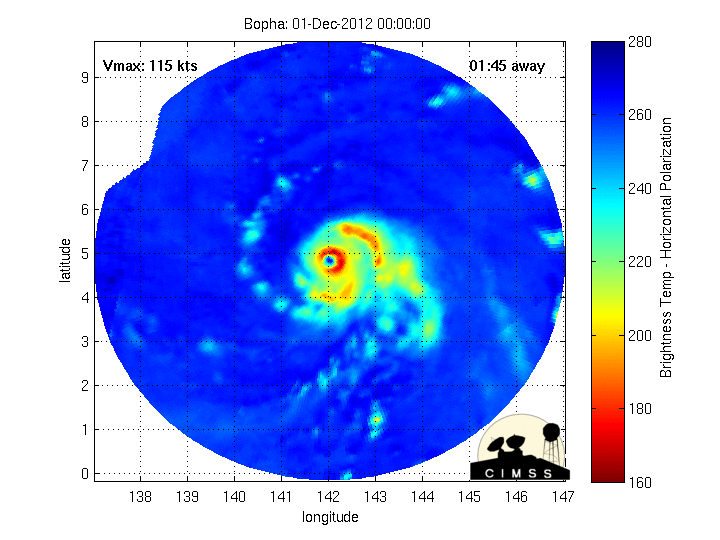
011200Z --- NEAR 5.4N 140.1E
MOVEMENT PAST SIX HOURS - 290 DEGREES AT 12 KTS
POSITION ACCURATE TO WITHIN 020 NM
POSITION BASED ON EYE FIXED BY SATELLITE
PRESENT WIND DISTRIBUTION:
MAX SUSTAINED WINDS - 115 KT, GUSTS 140 KT
WIND RADII VALID OVER OPEN WATER ONLY
RADIUS OF 064 KT WINDS - 030 NM NORTHEAST QUADRANT
030 NM SOUTHEAST QUADRANT
030 NM SOUTHWEST QUADRANT
030 NM NORTHWEST QUADRANT
RADIUS OF 050 KT WINDS - 060 NM NORTHEAST QUADRANT
050 NM SOUTHEAST QUADRANT
050 NM SOUTHWEST QUADRANT
060 NM NORTHWEST QUADRANT
RADIUS OF 034 KT WINDS - 105 NM NORTHEAST QUADRANT
100 NM SOUTHEAST QUADRANT
100 NM SOUTHWEST QUADRANT
105 NM NORTHWEST QUADRANT
REPEAT POSIT: 5.4N 140.1E
---
FORECASTS:
12 HRS, VALID AT:
020000Z --- 6.1N 137.8E
MAX SUSTAINED WINDS - 120 KT, GUSTS 145 KT
WIND RADII VALID OVER OPEN WATER ONLY
RADIUS OF 064 KT WINDS - 035 NM NORTHEAST QUADRANT
030 NM SOUTHEAST QUADRANT
035 NM SOUTHWEST QUADRANT
035 NM NORTHWEST QUADRANT
RADIUS OF 050 KT WINDS - 065 NM NORTHEAST QUADRANT
055 NM SOUTHEAST QUADRANT
055 NM SOUTHWEST QUADRANT
065 NM NORTHWEST QUADRANT
RADIUS OF 034 KT WINDS - 110 NM NORTHEAST QUADRANT
105 NM SOUTHEAST QUADRANT
105 NM SOUTHWEST QUADRANT
110 NM NORTHWEST QUADRANT
VECTOR TO 24 HR POSIT: 285 DEG/ 13 KTS
---
24 HRS, VALID AT:
021200Z --- 6.7N 135.2E
MAX SUSTAINED WINDS - 125 KT, GUSTS 150 KT
WIND RADII VALID OVER OPEN WATER ONLY
RADIUS OF 064 KT WINDS - 035 NM NORTHEAST QUADRANT
035 NM SOUTHEAST QUADRANT
035 NM SOUTHWEST QUADRANT
035 NM NORTHWEST QUADRANT
RADIUS OF 050 KT WINDS - 065 NM NORTHEAST QUADRANT
060 NM SOUTHEAST QUADRANT
060 NM SOUTHWEST QUADRANT
065 NM NORTHWEST QUADRANT
RADIUS OF 034 KT WINDS - 115 NM NORTHEAST QUADRANT
110 NM SOUTHEAST QUADRANT
110 NM SOUTHWEST QUADRANT
115 NM NORTHWEST QUADRANT
VECTOR TO 36 HR POSIT: 285 DEG/ 13 KTS
---
36 HRS, VALID AT:
030000Z --- 7.4N 132.7E
MAX SUSTAINED WINDS - 125 KT, GUSTS 150 KT
WIND RADII VALID OVER OPEN WATER ONLY
RADIUS OF 064 KT WINDS - 040 NM NORTHEAST QUADRANT
040 NM SOUTHEAST QUADRANT
040 NM SOUTHWEST QUADRANT
040 NM NORTHWEST QUADRANT
RADIUS OF 050 KT WINDS - 065 NM NORTHEAST QUADRANT
060 NM SOUTHEAST QUADRANT
060 NM SOUTHWEST QUADRANT
065 NM NORTHWEST QUADRANT
RADIUS OF 034 KT WINDS - 115 NM NORTHEAST QUADRANT
110 NM SOUTHEAST QUADRANT
110 NM SOUTHWEST QUADRANT
120 NM NORTHWEST QUADRANT
VECTOR TO 48 HR POSIT: 285 DEG/ 13 KTS
---
EXTENDED OUTLOOK:
48 HRS, VALID AT:
031200Z --- 8.2N 130.1E
MAX SUSTAINED WINDS - 125 KT, GUSTS 150 KT
WIND RADII VALID OVER OPEN WATER ONLY
RADIUS OF 064 KT WINDS - 040 NM NORTHEAST QUADRANT
040 NM SOUTHEAST QUADRANT
040 NM SOUTHWEST QUADRANT
040 NM NORTHWEST QUADRANT
RADIUS OF 050 KT WINDS - 065 NM NORTHEAST QUADRANT
065 NM SOUTHEAST QUADRANT
065 NM SOUTHWEST QUADRANT
070 NM NORTHWEST QUADRANT
RADIUS OF 034 KT WINDS - 120 NM NORTHEAST QUADRANT
115 NM SOUTHEAST QUADRANT
115 NM SOUTHWEST QUADRANT
120 NM NORTHWEST QUADRANT
VECTOR TO 72 HR POSIT: 290 DEG/ 14 KTS
---
72 HRS, VALID AT:
041200Z --- 10.0N 124.8E
MAX SUSTAINED WINDS - 100 KT, GUSTS 125 KT
WIND RADII VALID OVER OPEN WATER ONLY
RADIUS OF 064 KT WINDS - 035 NM NORTHEAST QUADRANT
035 NM SOUTHEAST QUADRANT
035 NM SOUTHWEST QUADRANT
035 NM NORTHWEST QUADRANT
RADIUS OF 050 KT WINDS - 060 NM NORTHEAST QUADRANT
060 NM SOUTHEAST QUADRANT
060 NM SOUTHWEST QUADRANT
065 NM NORTHWEST QUADRANT
RADIUS OF 034 KT WINDS - 120 NM NORTHEAST QUADRANT
110 NM SOUTHEAST QUADRANT
115 NM SOUTHWEST QUADRANT
120 NM NORTHWEST QUADRANT
VECTOR TO 96 HR POSIT: 295 DEG/ 09 KTS
---
LONG RANGE OUTLOOK:
---
96 HRS, VALID AT:
051200Z --- 11.6N 121.4E
MAX SUSTAINED WINDS - 075 KT, GUSTS 090 KT
WIND RADII VALID OVER OPEN WATER ONLY
VECTOR TO 120 HR POSIT: 310 DEG/ 07 KTS
---
120 HRS, VALID AT:
061200Z --- 13.3N 119.2E
MAX SUSTAINED WINDS - 065 KT, GUSTS 080 KT
WIND RADII VALID OVER OPEN WATER ONLY
---
REMARKS:
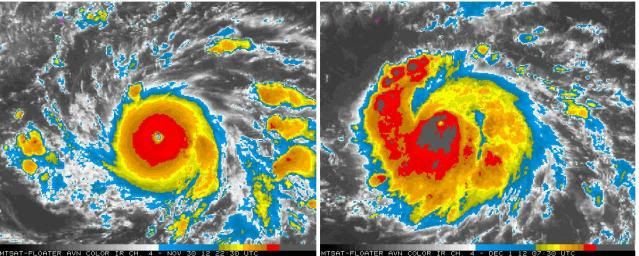
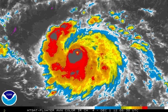
011500Z POSITION NEAR 5.6N 139.5E.
TYPHOON (TY) 26W (BOPHA) LOCATED APPROXIMATELY 350 NM EAST-SOUTHEAST
OF PALAU, HAS TRACKED WEST-NORTHWESTWARD AT 12 KNOTS OVER THE PAST
SIX HOURS. MAXIMUM SIGNIFICANT WAVE HEIGHT AT 011200Z IS 42 FEET.
NEXT WARNINGS AT 012100Z, 020300Z, 020900Z AND 021500Z.//
NNNN

Image
0 likes   
Visit the Caribbean-Central America Weather Thread where you can find at first post web cams,radars
and observations from Caribbean basin members Click Here

dexterlabio
Category 5
Category 5
Posts: 3466
Joined: Sat Oct 24, 2009 11:50 pm

Re:

#336 Postby dexterlabio » Sat Dec 01, 2012 9:24 am

Meow wrote:The great joke from ADT.

Image


LOL. a proof that ADT is sometimes unreliable.
0 likes   
Personal Forecast Disclaimer:
The posts in this forum are NOT official forecast and should not be used as such. They are just the opinion of the poster and may or may not be backed by sound meteorological data. They are NOT endorsed by any professional institution or storm2k.org. For official information, please refer to the NHC and NWS products.

supercane4867
Category 5
Category 5
Posts: 4966
Joined: Wed Nov 14, 2012 10:43 am

Re: WPAC: BOPHA - Typhoon

#337 Postby supercane4867 » Sat Dec 01, 2012 9:37 am

Wow Bopha does looks much better than she was last night(this morning), soem very deep convection blow up, she's now trying to clear out the eye
Image
0 likes   

supercane4867
Category 5
Category 5
Posts: 4966
Joined: Wed Nov 14, 2012 10:43 am

Re: Re:

#338 Postby supercane4867 » Sat Dec 01, 2012 9:53 am

dexterlabio wrote:
Meow wrote:The great joke from ADT.


LOL. a proof that ADT is sometimes unreliable.


Again, LOL at the ADT :P

ADVANCED DVORAK TECHNIQUE
ADT-Version 8.1.3
Tropical Cyclone Intensity Algorithm

----- Current Analysis -----
Date : 01 DEC 2012 Time : 130000 UTC
Lat : 5:22:40 N Lon : 139:51:55 E


CI# /Pressure/ Vmax
6.2 / 946.6mb/119.8kt


Final T# Adj T# Raw T#
5.8 5.1 4.8

Center Temp : -73.7C Cloud Region Temp : -80.6C

Scene Type : UNIFORM CDO CLOUD REGION

Positioning Method : SPIRAL ANALYSIS

Ocean Basin : WEST PACIFIC
Dvorak CI > MSLP Conversion Used : PACIFIC

Tno/CI Rules : Constraint Limits : 0.7T/6hr
Weakening Flag : ON
Rapid Dissipation Flag : OFF
0 likes   

supercane4867
Category 5
Category 5
Posts: 4966
Joined: Wed Nov 14, 2012 10:43 am

Re: WPAC: BOPHA - Typhoon

#339 Postby supercane4867 » Sat Dec 01, 2012 10:05 am

ADT has finally found where the actual center is located

Image
0 likes   

User avatar
Hurricane_Luis
Category 2
Category 2
Posts: 723
Age: 27
Joined: Sat Jun 23, 2012 3:14 pm
Location: Tiptree, Essex, United Kingdom
Contact:

#340 Postby Hurricane_Luis » Sat Dec 01, 2012 10:18 am

Typhoon Bopha

Image
0 likes   


Return to “2012”

Who is online

Users browsing this forum: No registered users and 137 guests