000
URNT12 KNHC 061612 CCA
VORTEX DATA MESSAGE AL052012
A. 06/16:00:30Z
B. 16 deg 01 min N
080 deg 41 min W
C. 850 mb 1409 m
D. 55 kt
E. 059 deg 25 nm
F. 156 deg 62 kt
G. 073 deg 10 nm
H. 997 mb
I. 15 C / 1557 m
J. 22 C / 1471 m
K. 16 C / NA
L. CLOSED WALL
M. C15
N. 12345 / 8
O. 0.02 / 2 nm
P. AF302 0805A ERNESTO OB 18 CCA
MAX FL WIND 77 KT NW QUAD 13:19:00Z
MAX OUTBOUND FL WIND 31 KT SW QUAD 16:02:00Z
GOOD RADAR SIGNATURE
;
ATL: ERNESTO - Post-Tropical
Moderator: S2k Moderators
-
littlevince

- S2K Supporter

- Posts: 768
- Joined: Fri Oct 21, 2005 10:45 am
- Location: Portugal
Re: ATL: ERNESTO - Recon
0 likes
-
cycloneye

- Admin

- Posts: 148746
- Age: 69
- Joined: Thu Oct 10, 2002 10:54 am
- Location: San Juan, Puerto Rico
Re: ATL: ERNESTO - Tropical Storm
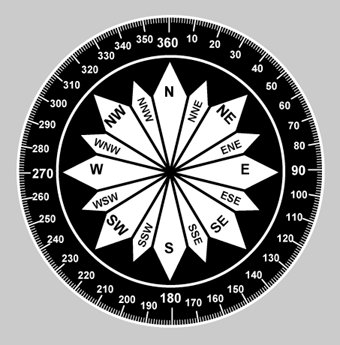
For those members who may not know about the movement in degrees as they appear in the advisories,here is a good tool. I see it right now between 300-310 degrees.
0 likes
Visit the Caribbean-Central America Weather Thread where you can find at first post web cams,radars
and observations from Caribbean basin members Click Here
and observations from Caribbean basin members Click Here
-
gatorcane

- S2K Supporter
- Posts: 23703
- Age: 47
- Joined: Sun Mar 13, 2005 3:54 pm
- Location: Boca Raton, FL
Looks like it is moving NW to me also. Question is will it resume a WNW movement or not...models think so. You can use this link and turn on LAT long grid to zoom in to see what looks to be a possible eye-like feature moving NW:
http://www.ssd.noaa.gov/goes/east/tatl/loop-vis.html
http://www.ssd.noaa.gov/goes/east/tatl/loop-vis.html
0 likes
-
brunota2003

- S2K Supporter
- Posts: 9476
- Age: 35
- Joined: Sat Jul 30, 2005 9:56 pm
- Location: Stanton, KY...formerly Havelock, NC
- Contact:
-
Texashawk

- Category 2

- Posts: 579
- Joined: Tue Aug 14, 2007 1:50 am
- Location: Missouri City, TX (Houston)
Re: ATL: ERNESTO - Recon Discussions - Comments - Questions
Here we go.
000
URNT12 KNHC 061612 CCA
VORTEX DATA MESSAGE AL052012
A. 06/16:00:30Z
B. 16 deg 01 min N
080 deg 41 min W
C. 850 mb 1409 m
D. 55 kt
E. 059 deg 25 nm
F. 156 deg 62 kt
G. 073 deg 10 nm
H. 997 mb
I. 15 C / 1557 m
J. 22 C / 1471 m
K. 16 C / NA
L. CLOSED WALL
M. C15
N. 12345 / 8
O. 0.02 / 2 nm
P. AF302 0805A ERNESTO OB 18 CCA
MAX FL WIND 77 KT NW QUAD 13:19:00Z
MAX OUTBOUND FL WIND 31 KT SW QUAD 16:02:00Z
GOOD RADAR SIGNATURE
;
0 likes
-
Weatherfreak000
Re: ATL: ERNESTO - Tropical Storm
hey Ivan, how do you feel about in between WNW and NW during transitional phases and more NW to NNW while he is ramping up and the eye is wobblin' about, sound possible?
I'm thinking Major cane is possible in a 24 hour time frame truly. He has already cleared Honduras and the more North he moves the more time over water he will have.
(Sorry Mods about forgetting the disclaimer)
Personal Forecast Disclaimer:
The posts in this forum are NOT official forecast and should not be used as such. They are just the opinion of the poster and may or may not be backed by sound meteorological data. They are NOT endorsed by any professional institution or storm2k.org. For official information, please refer to the NHC and NWS products.
0 likes
UZNT13 KNHC 061614
XXAA 56168 99160 70807 04560 99997 26823 19511 00527 ///// /////
92660 23234 18508 85399 22057 28513 88999 77999
31313 09608 81600
61616 AF302 0805A ERNESTO OB 19
62626 EYE SPL 1602N08069W 1603 MBL WND 19508 AEV 20802 DLM WND 22
508 996842 WL150 20010 084 REL 1601N08069W 160044 SPG 1602N08069W
160211 =
XXBB 56168 99160 70807 04560 00997 26823 11947 23415 22850 22057
21212 00997 19511 11938 18006 22871 25513 33859 28511 44852 28513
55842 30514
31313 09608 81600
61616 AF302 0805A ERNESTO OB 19
62626 EYE SPL 1602N08069W 1603 MBL WND 19508 AEV 20802 DLM WND 22
508 996842 WL150 20010 084 REL 1601N08069W 160044 SPG 1602N08069W
160211 =
;
0 likes
-
wxwatcher1999
- Category 1

- Posts: 264
- Joined: Sat Aug 04, 2012 10:19 am
So how much of a difference wil it be as far as landfall if he is moving nw as opposed to wnw?
0 likes
Personal Forecast Disclaimer:
The posts in this forum are NOT official forecast and should not be used as such. They are just the opinion of the poster and may or may not be backed by sound meteorological data. They are NOT endorsed by any professional institution or storm2k.org. For official information, please refer to the NHC and NWS products.
The posts in this forum are NOT official forecast and should not be used as such. They are just the opinion of the poster and may or may not be backed by sound meteorological data. They are NOT endorsed by any professional institution or storm2k.org. For official information, please refer to the NHC and NWS products.
-
tolakram
- Admin
- Posts: 20168
- Age: 62
- Joined: Sun Aug 27, 2006 8:23 pm
- Location: Florence, KY (name is Mark)
Re: ATL: ERNESTO - Tropical Storm
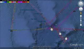
A graphic of my best guess on direction, fitting a line over the first and last center measurements. Still not enough to really be confident of the direction.

Personal Forecast Disclaimer:
The posts in this forum are NOT official forecast and should not be used as such. They are just the opinion of the poster and may or may not be backed by sound meteorological data. They are NOT endorsed by any professional institution or storm2k.org. For official information, please refer to the NHC and NWS products.
0 likes
M a r k
- - - - -
Join us in chat: Storm2K Chatroom Invite. Android and IOS apps also available.
The posts in this forum are NOT official forecasts and should not be used as such. Posts are NOT endorsed by any professional institution or STORM2K.org. For official information and forecasts, please refer to NHC and NWS products.
-
Weatherfreak000
Re:
wxwatcher1999 wrote:So how much of a difference wil it be as far as landfall if he is moving nw as opposed to wnw?
Impossible to know for sure, but if we start noticing him making any NNW jogs it will be time to worry. If ernie moves NW to NNW he can perhaps even still make it out near the Central GOM...landfall in Yucatan is however probably still inevitable.
See S2K Disclaimer for official info, not a forecast, just speculation.
0 likes

Re:
wxwatcher1999 wrote:So how much of a difference wil it be as far as landfall if he is moving nw as opposed to wnw?
the most immediate difference is that it will no longer run into Central America as it was thought by many yesterday; long term, could be difference between Belize or Mexico landfall
and I've got to say, this storm has been the biggest troll of a storm that's come along in quite awhile
personal opinion and not official forecast
edit: the pressure is coming back up it seems

Last edited by Hammy on Mon Aug 06, 2012 11:29 am, edited 1 time in total.
0 likes
The above post is not official and should not be used as such. It is the opinion of the poster and may or may not be backed by sound meteorological data. It is not endorsed by any professional institution or storm2k.org. For official information, please refer to the NHC and NWS products.
-
Ivanhater

- Storm2k Moderator

- Posts: 11183
- Age: 39
- Joined: Fri Jul 01, 2005 8:25 am
- Location: Pensacola
Re: ATL: ERNESTO - Tropical Storm
The NW movement at this time is more significant for clearing Honduras by a good margin and allowing for more robust strengthening .
0 likes
Michael
-
Stormcenter
- S2K Supporter
- Posts: 6687
- Joined: Wed Sep 03, 2003 11:27 am
- Location: Houston, TX
Re: Re:
So now you think Ernesto is headed to the NW GOM? I wouldn't bet on that just yet. IMO
Weatherfreak000 wrote:Weatherfreak000 wrote:Wow....any vets still awake? I don't have a solid visible to confirm but i'm wondering if Ernie is trying to pull the LLC East under the convection?
I'm sorry everyone I just had to re-post this and brag one more time on my excellent call
As for the storm, throw out all forecast ideas. Ernie now will control his own fate, throw out the models too. Ernie could bomb out to a cat 3/4 and stairstep NW/NNW right up to the Eastern tip of the Yucatan i've seen it happen before.
Edit: That's no wobble folks, he's moving NW now, and as he gets stronger and stronger, he will stairstep more and more northerly. Bombs away.
Personal Forecast Disclaimer:
The posts in this forum are NOT official forecast and should not be used as such. They are just the opinion of the poster and may or may not be backed by sound meteorological data. They are NOT endorsed by any professional institution or storm2k.org. For official information, please refer to the NHC and NWS products.
Last edited by Stormcenter on Mon Aug 06, 2012 11:35 am, edited 1 time in total.
0 likes


0 likes
I am just an amateur and a "noob" at that so any speculations that I have made are just that, uneducated speculations. Please refer to the NHC for accurate information.
Thank you all for your thoughts, I've loved reading through this community since '06 and finally decided to post more actively.
-JJ
Thank you all for your thoughts, I've loved reading through this community since '06 and finally decided to post more actively.
-JJ
-
wxman57

- Moderator-Pro Met

- Posts: 23130
- Age: 68
- Joined: Sat Jun 21, 2003 8:06 pm
- Location: Houston, TX (southwest)
Re: ATL: ERNESTO - Tropical Storm
Regardless of Ernesto's strengthening today, there doesn't appear to be anything to steer it northward. It should continue moving WNW and track across the southern Yucatan and southern BoC. Probably staying south of 20N.
0 likes
-
littlevince
- S2K Supporter
- Posts: 768
- Joined: Fri Oct 21, 2005 10:45 am
- Location: Portugal
Re: ATL: ERNESTO - Recon
000
URNT15 KNHC 061620
AF302 0805A ERNESTO HDOB 46 20120806
161200 1535N 08109W 8430 01563 0094 +162 +154 310010 012 014 002 00
161230 1534N 08110W 8429 01564 0092 +164 +153 308010 011 014 001 00
161300 1533N 08111W 8433 01562 0094 +163 +152 287010 011 011 001 00
161330 1531N 08112W 8428 01567 0094 +165 +152 295010 010 016 000 00
161400 1530N 08113W 8429 01567 0092 +168 +152 308010 011 012 002 00
161430 1529N 08115W 8430 01566 0093 +166 +151 320010 011 014 002 00
161500 1528N 08116W 8430 01567 0097 +164 +152 311008 009 014 002 00
161530 1527N 08117W 8429 01568 0095 +165 +152 304009 010 013 001 00
161600 1526N 08118W 8432 01567 0096 +165 +152 314010 010 010 001 00
161630 1524N 08119W 8431 01567 0098 +165 +152 322010 011 008 000 00
161700 1523N 08120W 8433 01566 0099 +166 +152 319009 010 006 000 00
161730 1522N 08122W 8429 01570 0100 +164 +153 321008 008 005 000 00
161800 1521N 08123W 8430 01569 0101 +165 +153 326007 008 003 001 00
161830 1520N 08124W 8430 01570 0098 +169 +154 329007 008 005 000 00
161900 1518N 08125W 8432 01568 0095 +171 +154 332007 007 005 000 00
161930 1517N 08126W 8429 01572 0095 +175 +155 334008 008 005 000 00
162000 1516N 08128W 8433 01568 0093 +176 +156 323006 008 007 000 00
162030 1515N 08129W 8433 01570 0096 +172 +158 311006 007 004 000 03
162100 1513N 08128W 8426 01577 0097 +170 +160 302007 008 /// /// 03
162130 1514N 08126W 8438 01564 0096 +175 +163 289006 007 007 000 00
$$
;
0 likes
-
Bocadude85

- Category 5

- Posts: 2990
- Age: 39
- Joined: Mon Apr 18, 2005 2:20 pm
- Location: Honolulu,Hi
Re: ATL: ERNESTO - Tropical Storm
tolakram wrote:A graphic of my best guess on direction, fitting a line over the first and last center measurements. Still not enough to really be confident of the direction.
http://img690.imageshack.us/img690/784/zztemp.jpg
Personal Forecast Disclaimer:
The posts in this forum are NOT official forecast and should not be used as such. They are just the opinion of the poster and may or may not be backed by sound meteorological data. They are NOT endorsed by any professional institution or storm2k.org. For official information, please refer to the NHC and NWS products.
If Ernesto stays on that heading then landfall would be around the Tulum area.
0 likes

Re: ATL: ERNESTO - Tropical Storm
tolakram wrote:Latest Loop

Gotta be one of the fastest spin-ups I have seen.
That overshooting top at 15.9N 80.1W really kicked it off.
http://www.ssd.noaa.gov/PS/TROP/floater ... -long.html
0 likes
-
brunota2003
- S2K Supporter
- Posts: 9476
- Age: 35
- Joined: Sat Jul 30, 2005 9:56 pm
- Location: Stanton, KY...formerly Havelock, NC
- Contact:
Who is online
Users browsing this forum: No registered users and 52 guests