

I'm personally hoping that it drifts a bit out into the ocean or just heads straight north. I would love so see rain here in south Texas~
That said, if it ends up to drift away towards LA, and not really form into anything larger that could sideswipe us, it'll just make my area have not even a cloud as it passes by. ;/
ATL: INVEST 95L
Moderator: S2k Moderators
Re: ATL: INVEST 95L
0 likes
The following post is NOT an official forecast and should not be used as such. It is just the opinion of the poster and may or may not be backed by sound meteorological data. It is NOT endorsed by any professional institution including storm2k.org. For Official Information please refer to the NHC and NWS products.
I love to draw~
I love to draw~

Re: Re:
bamajammer4eva wrote:Dean4Storms wrote:JB thinks it has a chance.....
https://twitter.com/BigJoeBastardi/stat ... 88/photo/1
He's been saying for days lookout Southeast US-maybe this is what he meant
LOL, he's been saying that every year at about this time, no matter what!
Oh well, he is a Pro Met so he deserves some cred I guess.
0 likes
-
ozonepete
- Professional-Met

- Posts: 4743
- Joined: Mon Sep 07, 2009 3:23 pm
- Location: From Ozone Park, NYC / Now in Brooklyn, NY
Re: ATL: INVEST 95L
I'm thinking this goes orange at 8PM. It looks like an LLC has formed and it's not going inland.
Personal Forecast Disclaimer:
The posts in this forum are NOT official forecast and should not be used as such. They are just the opinion of the poster and may or may not be backed by sound meteorological data. They are NOT endorsed by any professional institution or storm2k.org. For official information, please refer to the NHC and NWS products.
0 likes

Probably a code orange at 11. Can you imagine if this and Helene was off the coast of, say, Texas? Two tropical systems forming back to back like this, it's amazing and pretty rare, no? In-fricking-sane.
0 likes
I'm no expert, everything I say should be taken with a large amount of salt. I could easily be very, very wrong.
~Zanthe Go Coyotes~
~Zanthe Go Coyotes~
-
lester

- S2K Supporter

- Posts: 1305
- Age: 37
- Joined: Sat Aug 27, 2005 5:21 pm
- Location: Washington, DC
- Contact:
2. CLOUDINESS AND SHOWERS LOCATED OVER THE SOUTHWESTERN GULF OF
MEXICO ARE ASSOCIATED WITH A SURFACE TROUGH. SOME GRADUAL
DEVELOPMENT OF THIS SYSTEM IS POSSIBLE AS LONG AS THE SYSTEM STAYS
OFFSHORE DURING THE NEXT DAY OR SO. THIS SYSTEM HAS A LOW
CHANCE...20 PERCENT...OF BECOMING A TROPICAL CYCLONE DURING THE
NEXT 48 HOURS. REGARDLESS OF DEVELOPMENT...HEAVY RAINFALL IS
POSSIBLE IN THE MEXICAN STATES OF TAMAULIPAS AND VERACRUZ DURING
THE NEXT DAY OR TWO.
0 likes
-
Dean4Storms
- S2K Supporter
- Posts: 6358
- Age: 63
- Joined: Sun Aug 31, 2003 1:01 pm
- Location: Miramar Bch. FL
-
hurricanes1234
- Category 5

- Posts: 2908
- Joined: Sat Jul 28, 2012 6:19 pm
- Location: Trinidad and Tobago
Re: ATL: INVEST 95L
Why did all the convection dissipate? 

0 likes
PLEASE NOTE: With the exception of information from weather agencies that I may copy and paste here, my posts will NEVER be official, since I am NOT a meteorologist. They are solely my amateur opinion, and may or may not be accurate. Therefore, please DO NOT use them as official details, particularly when making important decisions. Thank you.

Re: ATL: INVEST 95L
because it has nothing at the surface to sustain the MLC....did this last night also....
0 likes
Re: ATL: INVEST 95L
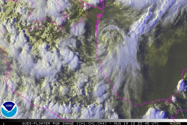
I dunno. Just looked at RGB...while there certainly is a lot of twisting going on, I'd expect the convection to be a lot deeper with an LLC. There's no shear (again, judging this from satellite), so I'd expect an LLC to really be firing off some deep convection...which does not seem to be the case.
What do you see?
What do you see?
0 likes
-
SouthernMet

- Category 3

- Posts: 857
- Joined: Sun Aug 29, 2010 8:23 pm
- Location: fort worth, tx
Re: ATL: INVEST 95L
The reason the convection has dramatically weakened is because it has been over the same waters for 2 days with very little movement.. And yes, though convection has waned, the overall structure has better defined itself.(LLC appearing)
Stay tuned
Stay tuned
0 likes
Nothing that SouthernMet posts, is an official forecast,nor does it reflect views of STORM2K.. SouthernMet is just adding to the great discussions on STORM2K.. Refer to NWS for official forecasts.
Re: ATL: INVEST 95L
Well, OK, but if there was upwelling, there wouldn't be enough convection firing in the first place to create an LLC. Again, I dunno. Pretty impossible to tell at night. Maybe, maybe not.
0 likes
-
wxman57

- Moderator-Pro Met

- Posts: 23172
- Age: 68
- Joined: Sat Jun 21, 2003 8:06 pm
- Location: Houston, TX (southwest)
Re: ATL: INVEST 95L
ozonepete wrote:Am I the only one who sees an LLC there? Looks pretty clear to me.
That rotation is not at the surface, it's probably 10,000-15,000 feet up or so. No chance of it coming to Texas as an upper-level trof is digging down across Texas tomorrow/Tuesday. NW winds aloft reaching the TX coast tomorrow morning (and SW winds ahead of that) would steer anything in the NW Gulf northeastward. That also means increasing shear as the system encounters the frontal zone. An unusually strong front for August. This system does not appear to be a tropical threat.
0 likes
-
ozonepete
- Professional-Met
- Posts: 4743
- Joined: Mon Sep 07, 2009 3:23 pm
- Location: From Ozone Park, NYC / Now in Brooklyn, NY
Re: ATL: INVEST 95L
One reason why you can have a "naked swirl" LLC without any convection in the absence of shear is dry air. It's probably taken in dry air from subsiding air coming down from the mountains just inland from the coast. It will have a battle with this for a while, but since most of the circulation is over water the whole environment should ventually moisten up. but there is pretty clearly an LLC there if you look at the RGB satellite image.
0 likes
-
northjaxpro

- S2K Supporter
- Posts: 8900
- Joined: Mon Sep 27, 2010 11:21 am
- Location: Jacksonville, FL
OzonePete, the RGB image shows the low level swirl quite well just off the coast.
0 likes
NEVER, EVER SAY NEVER in the tropics and weather in general, and most importantly, with life itself!!
________________________________________________________________________________________
Fay 2008 Beryl 2012 Debby 2012 Colin 2016 Hermine 2016 Julia 2016 Matthew 2016 Irma 2017 Dorian 2019
________________________________________________________________________________________
Fay 2008 Beryl 2012 Debby 2012 Colin 2016 Hermine 2016 Julia 2016 Matthew 2016 Irma 2017 Dorian 2019
-
Aric Dunn
- Category 5
- Posts: 21238
- Age: 43
- Joined: Sun Sep 19, 2004 9:58 pm
- Location: Ready for the Chase.
- Contact:
I still find it amazing that the models were able to resolve such obscure system.
0 likes
Note: If I make a post that is brief. Please refer back to previous posts for the analysis or reasoning. I do not re-write/qoute what my initial post said each time.
If there is nothing before... then just ask
Space & Atmospheric Physicist, Embry-Riddle Aeronautical University,
I believe the sky is falling...
If there is nothing before... then just ask
Space & Atmospheric Physicist, Embry-Riddle Aeronautical University,
I believe the sky is falling...
-
WilmingtonSandbar
- S2K Supporter
- Posts: 505
- Joined: Sun Aug 29, 2010 12:11 pm
- Location: Southport, NC
Re: ATL: INVEST 95L
Just a question in case this should develop and move north to the CONUS. Have we ever had a recorded simultaneous double hit of 2 tropical cyclones on the CONUS. In other words, if 94L and 95L spun up and both made landfalls on the CONUS, has that happened before?
0 likes
Diana X2 (look it up), Bertha, Fran, Bonnie, Floyd, Dennis, Charley, Ophelia, Ernesto, Irene, Matthew, And Florence
Re: ATL: INVEST 95L
WilmingtonSandbar wrote:Just a question in case this should develop and move north to the CONUS. Have we ever had a recorded simultaneous double hit of 2 tropical cyclones on the CONUS. In other words, if 94L and 95L spun up and both made landfalls on the CONUS, has that happened before?
Bonnie and Charley struck in quick succession in 2004.
0 likes
-
WilmingtonSandbar
- S2K Supporter
- Posts: 505
- Joined: Sun Aug 29, 2010 12:11 pm
- Location: Southport, NC
Re: ATL: INVEST 95L
psyclone wrote:WilmingtonSandbar wrote:Just a question in case this should develop and move north to the CONUS. Have we ever had a recorded simultaneous double hit of 2 tropical cyclones on the CONUS. In other words, if 94L and 95L spun up and both made landfalls on the CONUS, has that happened before?
Bonnie and Charley struck in quick succession in 2004.
But nothing at the same time? Like Gulf coast impact and an east coast impact on the same day?
I'm just wondering how they would split Jim Cantore in two?

0 likes
Diana X2 (look it up), Bertha, Fran, Bonnie, Floyd, Dennis, Charley, Ophelia, Ernesto, Irene, Matthew, And Florence
-
vbhoutex

- Storm2k Executive

- Posts: 29145
- Age: 74
- Joined: Wed Oct 09, 2002 11:31 pm
- Location: Cypress, TX
- Contact:
Re: ATL: INVEST 95L
Let's take the discussion back to 95L please.
0 likes
Skywarn, C.E.R.T.
Please click below to donate to STORM2K to help with the expenses of keeping the site going:

Please click below to donate to STORM2K to help with the expenses of keeping the site going:
Who is online
Users browsing this forum: No registered users and 89 guests