
^^^
Models seem to be shifting a tad left am I right?
ATL: LESLIE - Models
Moderator: S2k Moderators
Re: ATL: INVEST 98L - Models
looks like it's following kirk's weakness
thou kirk may lift out early enough for invest 98 not to get suck'd all the way OTS , ridge may build back in ?
thou kirk may lift out early enough for invest 98 not to get suck'd all the way OTS , ridge may build back in ?
0 likes

Re: ATL: INVEST 98L - Models
18z does kick this out late but shows the weakness filling in and much more ridging in place. If it somehow stays weaker i think it will not feel the weakness.
Look at 102hr Kirk is long gone and ridge filling back in
http://raleighwx.americanwx.com/models/ ... cal102.gif
Look at 102hr Kirk is long gone and ridge filling back in
http://raleighwx.americanwx.com/models/ ... cal102.gif
0 likes
The following post is NOT an official forecast and should not be used as such. It is just the opinion of the poster and may or may not be backed by sound meteorological data. It is NOT endorsed by any professional institution including storm2k.org For Official Information please refer to the NHC and NWS products.

Well 98L recurves around 60W on the 18z GFS but this is a long way out and the models have very much had a right bias this season thus far...
0 likes
Personal Forecast Disclaimer:
The posts in this forum are NOT official forecast and should not be used as such. They are just the opinion of the poster and may or may not be backed by sound meteorological data. They are NOT endorsed by any professional institution or storm2k.org. For official information, please refer to the NHC and NWS products
The posts in this forum are NOT official forecast and should not be used as such. They are just the opinion of the poster and may or may not be backed by sound meteorological data. They are NOT endorsed by any professional institution or storm2k.org. For official information, please refer to the NHC and NWS products
-
cycloneye

- Admin

- Posts: 149275
- Age: 69
- Joined: Thu Oct 10, 2002 10:54 am
- Location: San Juan, Puerto Rico
Re: ATL: INVEST 98L - Models
00z Models.
Code: Select all
WHXX01 KWBC 300303
CHGHUR
TROPICAL CYCLONE GUIDANCE MESSAGE
NWS NATIONAL HURRICANE CENTER MIAMI FL
0303 UTC THU AUG 30 2012

DISCLAIMER...NUMERICAL MODELS ARE SUBJECT TO LARGE ERRORS.
PLEASE REFER TO NHC OFFICIAL FORECASTS FOR TROPICAL CYCLONE
AND SUBTROPICAL CYCLONE INFORMATION.

ATLANTIC OBJECTIVE AIDS FOR

DISTURBANCE INVEST (AL982012) 20120830 0000 UTC

        ...00 HRS...   ...12 HRS...   ...24 HRS. ..   ...36 HRS...
        120830  0000   120830  1200   120831  0000   120831  1200

         LAT    LON     LAT    LON     LAT    LON     LAT    LON
BAMS    13.5N  39.3W   14.2N  41.0W   15.9N  43.0W   18.1N  46.1W
BAMD    13.5N  39.3W   13.9N  42.3W   14.4N  44.9W   15.1N  47.1W
BAMM    13.5N  39.3W   14.1N  41.9W   15.2N  44.5W   16.3N  47.3W
LBAR    13.5N  39.3W   14.1N  42.8W   14.8N  46.5W   15.6N  50.3W
SHIP        30KTS          41KTS          53KTS          64KTS
DSHP        30KTS          41KTS          53KTS          64KTS

        ...48 HRS...   ...72 HRS...   ...96 HRS. ..   ..120 HRS...
        120901  0000   120902  0000   120903  0000   120904  0000

         LAT    LON     LAT    LON     LAT    LON     LAT    LON
BAMS    20.5N  49.8W   24.6N  57.3W   27.9N  62.3W   28.7N  66.0W
BAMD    15.9N  49.1W   18.0N  52.5W   21.4N  55.6W   26.9N  55.9W
BAMM    17.8N  50.1W   20.8N  56.2W   23.3N  60.8W   25.3N  61.8W
LBAR    16.4N  53.8W   18.0N  59.0W   21.0N  60.7W   26.2N  61.3W
SHIP        73KTS          85KTS          84KTS          87KTS
DSHP        73KTS          85KTS          84KTS          87KTS

         ...INITIAL CONDITIONS...
LATCUR =  13.5N LONCUR =  39.3W DIRCUR = 275DEG SPDCUR =  18KT
LATM12 =  13.3N LONM12 =  35.6W DIRM12 = 270DEG SPDM12 =  19KT
LATM24 =  13.3N LONM24 =  31.7W
WNDCUR =   30KT RMAXWD =   70NM WNDM12 =   25KT
CENPRS = 1007MB OUTPRS = 1012MB OUTRAD =  200NM SDEPTH =   S
RD34NE =    0NM RD34SE =    0NM RD34SW =    0NM RD34NW =   0NM
0 likes
Visit the Caribbean-Central America Weather Thread where you can find at first post web cams,radars
and observations from Caribbean basin members Click Here
and observations from Caribbean basin members Click Here

Re: ATL: INVEST 98L - Models
0Z GFS rolls in a few....see if anything changes....by the looks of current 98L I dont think its going to delay in developing...
0 likes

Re: ATL: INVEST 98L - Models
The sooner 98L develops, the more likely a fish storm it will be. If named, it would be Leslie. We have 10 named storms and no major hurricanes yet.
0 likes
Re: ATL: INVEST 98L - Models
0Z GFS out to sea before the islands.....sound like a broken record...
0 likes
-
MidnightRain

- Tropical Storm

- Posts: 110
- Joined: Tue Oct 11, 2011 8:26 pm
- Location: NW Florida
Re: ATL: INVEST 98L - Models
98L is is moving slower and is more developed than what Isaac was at this point, therefore I don't think the models bust on this one being a fish (at least not a U.S threat).
0 likes
The posts in this forum are NOT official forecast and should not be used as such. They are just the opinion of the poster and may or may not be backed by sound meteorological data. They are NOT endorsed by any professional institution or storm2k.org. For official information, please refer to the NHC and NWS products.
-
Nederlander
- S2K Supporter

- Posts: 1259
- Joined: Sat Jul 19, 2008 4:28 pm
- Location: Conroe, TX
Re: ATL: INVEST 98L - Models
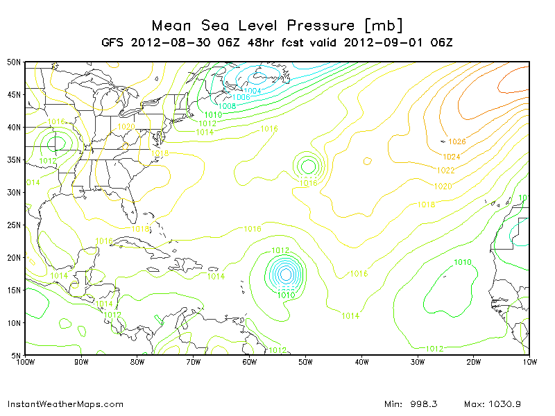
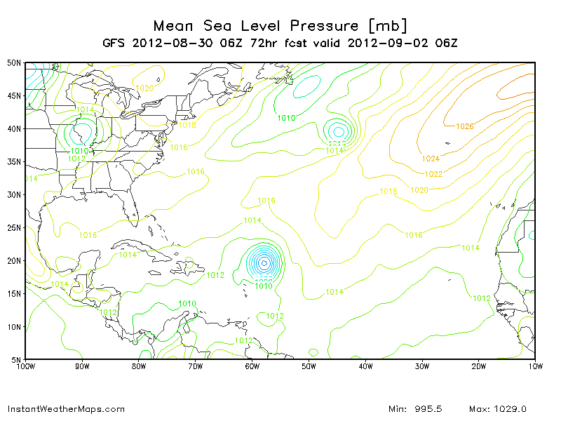
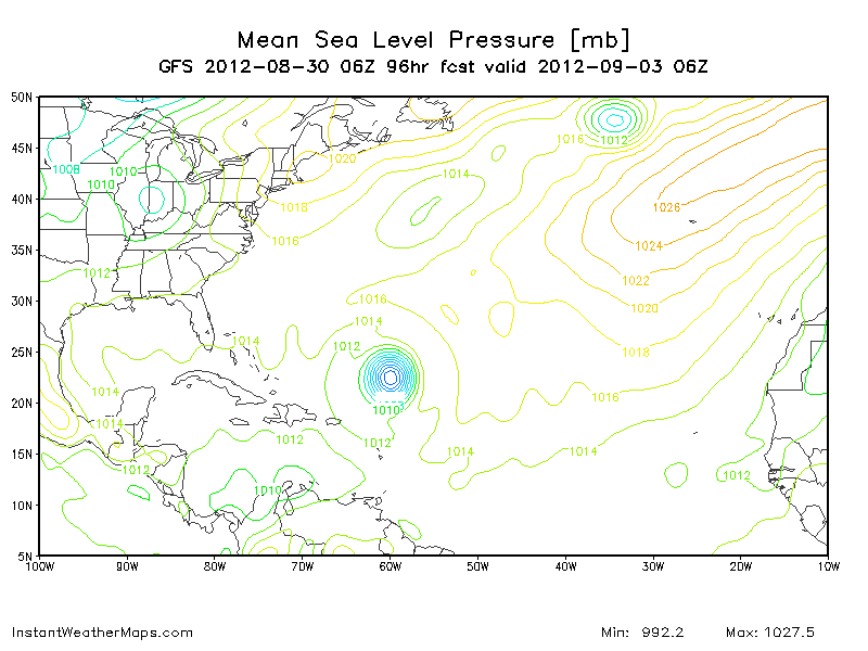
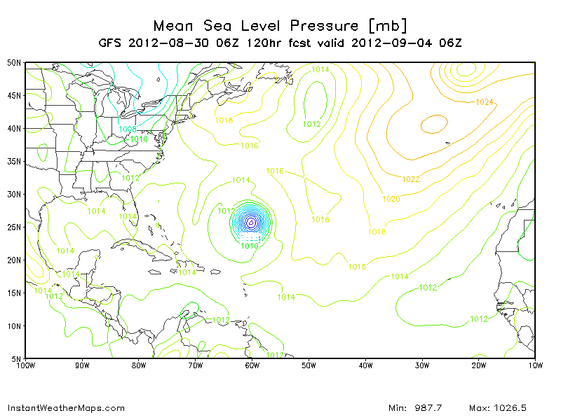
0Z GFS = FISH.. Pretty much follows Kirk's trail but gets a little more west.
At 126hr:

Uploaded with ImageShack.us
At 126hr:

Uploaded with ImageShack.us
0 likes

Might take it close to Bermuda?
0 likes
Personal Forecast Disclaimer:
My posts are just my opinion and are most likely not backed by sound meteorological data. They are NOT endorsed by any professional institution or storm2k.org. For official information, please refer to the NHC and NWS products.
Bottom line is that I am just expressing my opinion!!!
My posts are just my opinion and are most likely not backed by sound meteorological data. They are NOT endorsed by any professional institution or storm2k.org. For official information, please refer to the NHC and NWS products.
Bottom line is that I am just expressing my opinion!!!
-
ConvergenceZone
.gif)
- Category 5

- Posts: 5241
- Joined: Fri Jul 29, 2005 1:40 am
- Location: Northern California
ECM provides some fun and games this morning, system doesn't really totally recurve but instead gets stuckj and then slowly but surely erractically move NW to within a whisker of the NE...
I remember a trend like that from Issac when the models first started to shift westwards...
I remember a trend like that from Issac when the models first started to shift westwards...
0 likes
Personal Forecast Disclaimer:
The posts in this forum are NOT official forecast and should not be used as such. They are just the opinion of the poster and may or may not be backed by sound meteorological data. They are NOT endorsed by any professional institution or storm2k.org. For official information, please refer to the NHC and NWS products
The posts in this forum are NOT official forecast and should not be used as such. They are just the opinion of the poster and may or may not be backed by sound meteorological data. They are NOT endorsed by any professional institution or storm2k.org. For official information, please refer to the NHC and NWS products
Re: ATL: INVEST 98L - Models
Looks like a fishie (due to an absence of the subtropical high west of 40W over the next 5 - 7 days) - good because there's standing water everywhere here in South Florida, and now there's a concern about the West Nile virus, as mentioned on this morning's local news...
0 likes
-
cycloneye
- Admin
- Posts: 149275
- Age: 69
- Joined: Thu Oct 10, 2002 10:54 am
- Location: San Juan, Puerto Rico
Re: ATL: INVEST 98L - Models
12z Models.
Code: Select all
WHXX01 KWBC 301212
CHGHUR
TROPICAL CYCLONE GUIDANCE MESSAGE
NWS NATIONAL HURRICANE CENTER MIAMI FL
1212 UTC THU AUG 30 2012

DISCLAIMER...NUMERICAL MODELS ARE SUBJECT TO LARGE ERRORS.
PLEASE REFER TO NHC OFFICIAL FORECASTS FOR TROPICAL CYCLONE
AND SUBTROPICAL CYCLONE INFORMATION.

ATLANTIC OBJECTIVE AIDS FOR

TROPICAL CYCLONE TWELVE (AL122012) 20120830 1200 UTC

        ...00 HRS...   ...12 HRS...   ...24 HRS. ..   ...36 HRS...
        120830  1200   120831  0000   120831  1200   120901  0000

         LAT    LON     LAT    LON     LAT    LON     LAT    LON
BAMS    13.8N  42.6W   15.2N  44.6W   17.3N  47.2W   19.9N  50.6W
BAMD    13.8N  42.6W   14.6N  45.3W   15.6N  47.8W   16.8N  50.1W
BAMM    13.8N  42.6W   15.0N  45.2W   16.4N  48.0W   18.1N  50.9W
LBAR    13.8N  42.6W   14.6N  46.0W   15.5N  49.7W   16.4N  53.4W
SHIP        30KTS          38KTS          49KTS          60KTS
DSHP        30KTS          38KTS          49KTS          60KTS

        ...48 HRS...   ...72 HRS...   ...96 HRS. ..   ..120 HRS...
        120901  1200   120902  1200   120903  1200   120904  1200

         LAT    LON     LAT    LON     LAT    LON     LAT    LON
BAMS    22.1N  54.7W   24.8N  61.5W   25.2N  66.0W   23.5N  66.3W
BAMD    18.1N  52.0W   21.2N  55.7W   25.4N  56.8W   29.9N  55.4W
BAMM    19.7N  54.1W   21.7N  59.6W   23.1N  61.7W   24.7N  59.9W
LBAR    17.4N  56.7W   19.3N  60.7W   23.3N  61.7W   26.5N  61.4W
SHIP        68KTS          78KTS          80KTS          81KTS
DSHP        68KTS          78KTS          80KTS          81KTS

         ...INITIAL CONDITIONS...
LATCUR =  13.8N LONCUR =  42.6W DIRCUR = 275DEG SPDCUR =  17KT
LATM12 =  13.5N LONM12 =  39.1W DIRM12 = 274DEG SPDM12 =  17KT
LATM24 =  13.3N LONM24 =  35.6W
WNDCUR =   30KT RMAXWD =   50NM WNDM12 =   30KT
CENPRS = 1007MB OUTPRS = 1013MB OUTRAD =  250NM SDEPTH =   M
RD34NE =    0NM RD34SE =    0NM RD34SW =    0NM RD34NW =   0NM
0 likes
Visit the Caribbean-Central America Weather Thread where you can find at first post web cams,radars
and observations from Caribbean basin members Click Here
and observations from Caribbean basin members Click Here

Who is online
Users browsing this forum: No registered users and 22 guests