ATL: DEBBY - Post-Tropical

Moderator: S2k Moderators

Message
Author
User avatar
vaffie
Category 3
Category 3
Posts: 898
Joined: Sat Sep 11, 2004 5:11 pm
Location: Houston, Texas

Re: ATL: INVEST 96L - Discussion

#421 Postby vaffie » Fri Jun 22, 2012 12:05 am

ROCK wrote:
vaffie wrote:Looking at the buoy data from the GOM, it seems that pressures are dropping at a fair rate (2.5 mb drop in the past 24 hours) and winds are rising quickly tonight. At this rate, by midday tomorrow the pressure will be sufficiently low enough to have continuous convection over the center and rapid strengthening will ensue.

Two buoys are as follows for instance:

http://www.ndbc.noaa.gov/show_plot.php? ... _label=CDT

http://www.ndbc.noaa.gov/show_plot.php? ... _label=CDT


where are these located?


Middle of the Gulf, fairly far away. Unfortunately there are no buoys in the southern Gulf... :(
0 likes   

User avatar
vaffie
Category 3
Category 3
Posts: 898
Joined: Sat Sep 11, 2004 5:11 pm
Location: Houston, Texas

Re: ATL: INVEST 96L - Models

#422 Postby vaffie » Fri Jun 22, 2012 12:06 am

bella_may wrote:does anybody have a link of the cmc model? i cant seem to find it. thanks


One link is here, but it's not necessarily the first to update... Would love to know the one that is the first to update right now.
http://moe.met.fsu.edu/tcgengifs/
0 likes   

User avatar
ROCK
Category 5
Category 5
Posts: 9484
Age: 54
Joined: Tue Aug 17, 2004 7:30 am
Location: Kemah, Texas

Re: ATL: INVEST 96L - Discussion

#423 Postby ROCK » Fri Jun 22, 2012 12:07 am

I got a feeling this is going to have a large windfield due to the size.....like a WPAC system..
0 likes   

User avatar
cycloneye
Admin
Admin
Posts: 145308
Age: 68
Joined: Thu Oct 10, 2002 10:54 am
Location: San Juan, Puerto Rico

Re: ATL: INVEST 96L - Discussion

#424 Postby cycloneye » Fri Jun 22, 2012 12:10 am

IMO,unless things change in a dramatic way to a more organized system,I dont see the squadron going this afternoon.
0 likes   
Visit the Caribbean-Central America Weather Thread where you can find at first post web cams,radars
and observations from Caribbean basin members Click Here

User avatar
Rgv20
S2K Supporter
S2K Supporter
Posts: 2466
Age: 38
Joined: Wed Jan 05, 2011 5:42 pm
Location: Edinburg/McAllen Tx

#425 Postby Rgv20 » Fri Jun 22, 2012 12:13 am

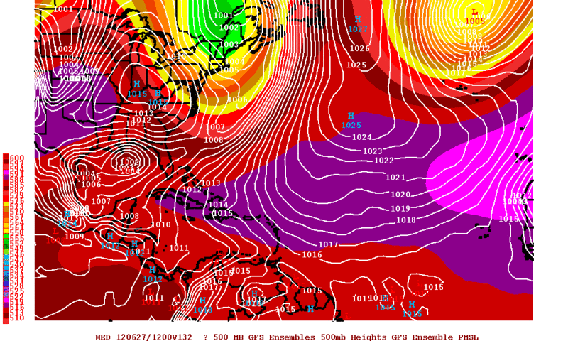
0zGFS Ensembles are fighting within themselves as to what to do with this possible TC........Some of the members are calling for a South Texas landfall around Wednesday.

Image
0 likes   
The following post is NOT an official forecast and should not be used as such. It is just the opinion of the poster and may or may not be backed by sound meteorological data. It is NOT endorsed by any professional institution including storm2k.org For Official Information please refer to the NHC and NWS products.

User avatar
ROCK
Category 5
Category 5
Posts: 9484
Age: 54
Joined: Tue Aug 17, 2004 7:30 am
Location: Kemah, Texas

Re: ATL: INVEST 96L - Discussion

#426 Postby ROCK » Fri Jun 22, 2012 12:14 am

cycloneye wrote:IMO,unless things change in a dramatic way to a more organized system,I dont see the squadron going this afternoon.


I dont know...I think the potential is there and it being in the GOM they might go out....its not that far of a flight.....
0 likes   

User avatar
vaffie
Category 3
Category 3
Posts: 898
Joined: Sat Sep 11, 2004 5:11 pm
Location: Houston, Texas

Re: ATL: INVEST 96L - Models

#427 Postby vaffie » Fri Jun 22, 2012 12:15 am

CMC seems to be out, if I am reading this correctly:
http://www.weatheroffice.gc.ca/model_fo ... 12_....jpg

It has almost the exact same track as the previous two runs--towards New Orleans, then a jog to the southwest and then drifts towards South/Central Texas.
0 likes   

User avatar
boca
Category 5
Category 5
Posts: 6367
Age: 60
Joined: Mon Dec 15, 2003 8:49 am
Location: Boca Raton,FL

Re:

#428 Postby boca » Fri Jun 22, 2012 12:16 am

Rgv20 wrote:0zGFS Ensembles are fighting within themselves as to what to do with this possible TC........Some of the members are calling for a South Texas landfall around Wednesday.

Image


Wow 2 lows thats not going to happen.
0 likes   

User avatar
cycloneye
Admin
Admin
Posts: 145308
Age: 68
Joined: Thu Oct 10, 2002 10:54 am
Location: San Juan, Puerto Rico

Re: ATL: INVEST 96L - Models

#429 Postby cycloneye » Fri Jun 22, 2012 12:18 am

00z CMC again has hurricane tracking towards Texas.
0 likes   
Visit the Caribbean-Central America Weather Thread where you can find at first post web cams,radars
and observations from Caribbean basin members Click Here

User avatar
Rgv20
S2K Supporter
S2K Supporter
Posts: 2466
Age: 38
Joined: Wed Jan 05, 2011 5:42 pm
Location: Edinburg/McAllen Tx

#430 Postby Rgv20 » Fri Jun 22, 2012 12:18 am

boca wrote:
Rgv20 wrote:0zGFS Ensembles are fighting within themselves as to what to do with this possible TC........Some of the members are calling for a South Texas landfall around Wednesday.

http://i61.photobucket.com/albums/h62/c ... cal132.gif


Wow 2 lows thats not going to happen.


Its not two lows, the Ensembles are 50/50 on where this possible TC is going to be located by Wednesday.
0 likes   
The following post is NOT an official forecast and should not be used as such. It is just the opinion of the poster and may or may not be backed by sound meteorological data. It is NOT endorsed by any professional institution including storm2k.org For Official Information please refer to the NHC and NWS products.

User avatar
ROCK
Category 5
Category 5
Posts: 9484
Age: 54
Joined: Tue Aug 17, 2004 7:30 am
Location: Kemah, Texas

Re: ATL: INVEST 96L - Models

#431 Postby ROCK » Fri Jun 22, 2012 12:20 am

cycloneye wrote:00z CMC again has hurricane tracking towards Texas.


4 runs now....you cannot deny it now,,,,especially if the EURO agrees later....
0 likes   

bella_may
Category 4
Category 4
Posts: 908
Joined: Wed Dec 22, 2010 2:13 pm
Location: SE Mississippi coast

#432 Postby bella_may » Fri Jun 22, 2012 12:22 am

still have a hard time believing this this will make that dramatic of a turn to the west. The cmc is hardly ever reliable too. will wait till the GFDL and ECMWF
Last edited by bella_may on Fri Jun 22, 2012 12:24 am, edited 2 times in total.
0 likes   

User avatar
vaffie
Category 3
Category 3
Posts: 898
Joined: Sat Sep 11, 2004 5:11 pm
Location: Houston, Texas

Re: ATL: INVEST 96L - Models

#433 Postby vaffie » Fri Jun 22, 2012 12:22 am

ROCK wrote:
cycloneye wrote:00z CMC again has hurricane tracking towards Texas.


4 runs now....you cannot deny it now,,,,especially if the EURO agrees later....


Yup, you've got to hand it to the CMC--4 runs of consistency is quite impressive if it pans out for a 5 day forecast that everyone else is flip-flopping on.
0 likes   

User avatar
ROCK
Category 5
Category 5
Posts: 9484
Age: 54
Joined: Tue Aug 17, 2004 7:30 am
Location: Kemah, Texas

Re: ATL: INVEST 96L - Models

#434 Postby ROCK » Fri Jun 22, 2012 12:24 am

vaffie wrote:
ROCK wrote:
cycloneye wrote:00z CMC again has hurricane tracking towards Texas.


4 runs now....you cannot deny it now,,,,especially if the EURO agrees later....


Yup, you've got to hand it to the CMC--4 runs of consistency is quite impressive if it pans out for a 5 day forecast that everyone else is flip-flopping on.


well it was upgraded last year....so maybe that is it....but that is a major global model showing the same now for 4 runs....
0 likes   

User avatar
South Texas Storms
Professional-Met
Professional-Met
Posts: 4226
Joined: Thu Jun 24, 2010 12:28 am
Location: Houston, TX

Re: ATL: INVEST 96L - Models

#435 Postby South Texas Storms » Fri Jun 22, 2012 12:25 am

Are you guys sure the cmc updated yet? I don't see it on the fsu site yet.
0 likes   

User avatar
vaffie
Category 3
Category 3
Posts: 898
Joined: Sat Sep 11, 2004 5:11 pm
Location: Houston, Texas

Re: ATL: INVEST 96L - Models

#436 Postby vaffie » Fri Jun 22, 2012 12:28 am

ROCK wrote:
well it was upgraded last year....so maybe that is it....but that is a major global model showing the same now for 4 runs....


Interestingly, the NOGAPS has had similar consistency for six runs now too--although it is further south with its tracks than the CMC.
0 likes   

User avatar
ROCK
Category 5
Category 5
Posts: 9484
Age: 54
Joined: Tue Aug 17, 2004 7:30 am
Location: Kemah, Texas

Re: ATL: INVEST 96L - Models

#437 Postby ROCK » Fri Jun 22, 2012 12:28 am

South Texas Storms wrote:Are you guys sure the cmc updated yet? I don't see it on the fsu site yet.


the FSU takes awhile to update...
0 likes   

User avatar
South Texas Storms
Professional-Met
Professional-Met
Posts: 4226
Joined: Thu Jun 24, 2010 12:28 am
Location: Houston, TX

Re: ATL: INVEST 96L - Models

#438 Postby South Texas Storms » Fri Jun 22, 2012 12:29 am

ROCK wrote:
South Texas Storms wrote:Are you guys sure the cmc updated yet? I don't see it on the fsu site yet.


the FSU takes awhile to update...


Where are you seeing the new run then?
0 likes   

User avatar
ROCK
Category 5
Category 5
Posts: 9484
Age: 54
Joined: Tue Aug 17, 2004 7:30 am
Location: Kemah, Texas

Re: ATL: INVEST 96L - Models

#439 Postby ROCK » Fri Jun 22, 2012 12:29 am

vaffie wrote:
ROCK wrote:
well it was upgraded last year....so maybe that is it....but that is a major global model showing the same now for 4 runs....


Interestingly, the NOGAPS has had similar consistency for six runs now too--although it is further south with its tracks than the CMC.


the UKMET has been showing this solution for awhile also....before the CMC really...interesting
0 likes   

User avatar
vaffie
Category 3
Category 3
Posts: 898
Joined: Sat Sep 11, 2004 5:11 pm
Location: Houston, Texas

Re: ATL: INVEST 96L - Models

#440 Postby vaffie » Fri Jun 22, 2012 12:30 am

South Texas Storms wrote:
Where are you seeing the new run then?


http://www.weatheroffice.gc.ca/model_fo ... 12_....jpg
0 likes   


Return to “2012”

Who is online

Users browsing this forum: No registered users and 7 guests