ATL: ERNESTO - Post-Tropical

Moderator: S2k Moderators

Message
Author
User avatar
cheezyWXguy
Category 5
Category 5
Posts: 6108
Joined: Mon Feb 13, 2006 12:29 am
Location: Dallas, TX

Re:

#4541 Postby cheezyWXguy » Tue Aug 07, 2012 9:51 pm

AJC3 wrote:I would be careful judging the strength or structure of the "far side" of the storm opposite the eye wall relative to the the Belize radar. Without knowing the specs of the radar, based on the IR satellite presentation, there is likely some serious attentuation of the beam going on.

Thats true, I have noticed that radar seems to present far side of the eye as weaker than than the near side. I highly doubt its being sheared, but believe its more likely strengthening wobbles being enhanced by Ernesto's reaction to its ever-increasing proximity to land.
0 likes   

User avatar
littlevince
S2K Supporter
S2K Supporter
Posts: 768
Joined: Fri Oct 21, 2005 10:45 am
Location: Portugal

Re: ATL: ERNESTO - Hurricane

#4542 Postby littlevince » Tue Aug 07, 2012 10:10 pm

Interesting loop

Image
0 likes   

User avatar
timmeister
Tropical Storm
Tropical Storm
Posts: 190
Age: 62
Joined: Thu Jan 06, 2011 11:17 am
Location: Hattiesburg, MS

Re: ATL: ERNESTO - Hurricane

#4543 Postby timmeister » Tue Aug 07, 2012 10:20 pm

Looks like he intensified right before landfall.
0 likes   
Personal Forecast Disclaimer:
The posts in this forum are NOT official forecast and should not be used as such. They are just the opinion of the poster and may or may not be backed by sound meteorological data. They are NOT endorsed by any professional institution or storm2k.org. For official information, please refer to the NHC and NWS products.

User avatar
Hurricane Alexis
Category 2
Category 2
Posts: 683
Age: 29
Joined: Thu Jun 14, 2012 7:59 pm
Location: Miami,Florida

#4544 Postby Hurricane Alexis » Tue Aug 07, 2012 10:25 pm

000
WTNT65 KNHC 080318
TCUAT5

HURRICANE ERNESTO TROPICAL CYCLONE UPDATE
NWS NATIONAL HURRICANE CENTER MIAMI FL AL052012
1015 PM CDT TUE AUG 07 2012

...BELIZE RADAR INDICATES ERNESTO HAS MADE LANDFALL ALONG THE
SOUTHERN YUCATAN COAST...

AT 1000 PM CDT...0300 UTC...DATA FROM THE BELIZE RADAR INDICATE
HURRICANE ERNESTO MADE LANDFALL ALONG THE SOUTHERN COAST OF THE
YUCATAN PENINSULA NEAR MAHAHUAL MEXICO AS A CATEGORY 1 HURRICANE.

SUMMARY OF 1000 PM CDT...0300 UTC...INFORMATION
-----------------------------------------------
LOCATION...18.7N 87.7W
ABOUT 0 MI...0 KM E OF MAHAHUAL MEXICO
ABOUT 40 MI...65 KM ENE OF CHETUMAL MEXICO
MAXIMUM SUSTAINED WINDS...85 MPH...140 KM/H
PRESENT MOVEMENT...W OR 270 DEGREES AT 15 MPH...24 KM/H
MINIMUM CENTRAL PRESSURE...980 MB...28.94 INCHES

$$
FORECASTER STEWART/CANGIALOSI
0 likes   
Personal Forecast Disclaimer:
The posts in this forum are NOT official forecast and should not be used as such. They are just the opinion of the poster and may or may not be backed by sound meteorological data. They are NOT endorsed by any professional institution or storm2k.org. For official information, please refer to the NHC and NWS products.

ozonepete
Professional-Met
Professional-Met
Posts: 4743
Joined: Mon Sep 07, 2009 3:23 pm
Location: From Ozone Park, NYC / Now in Brooklyn, NY

Re: ATL: ERNESTO - Hurricane

#4545 Postby ozonepete » Tue Aug 07, 2012 10:26 pm

timmeister wrote:Looks like he intensified right before landfall.


Oh boy are you right. It hit at max intensity for what it could be at the time.

(Just imho, but don't think anyone would argue...)
0 likes   

stephen23
Category 1
Category 1
Posts: 341
Joined: Sat Aug 04, 2012 10:57 pm
Location: North Fort Worth

Re: ATL: ERNESTO - Hurricane

#4546 Postby stephen23 » Tue Aug 07, 2012 10:27 pm

Pretty picture of the eye when he made landfall. How long will he head NW now across the Yucatan?
0 likes   
Personal Forecast Disclaimer:
The posts in this forum are NOT official forecast and should not be used as such. They are just the opinion of the poster and may or may not be backed by sound meteorological data. They are NOT endorsed by any professional institution or storm2k.org. For official information, please refer to the NHC and NWS products.

User avatar
cycloneye
Admin
Admin
Posts: 145308
Age: 68
Joined: Thu Oct 10, 2002 10:54 am
Location: San Juan, Puerto Rico

Re: ATL: ERNESTO - Hurricane

#4547 Postby cycloneye » Tue Aug 07, 2012 10:29 pm

HURRICANE ERNESTO TROPICAL CYCLONE UPDATE
NWS NATIONAL HURRICANE CENTER MIAMI FL AL052012
1015 PM CDT TUE AUG 07 2012

...BELIZE RADAR INDICATES ERNESTO HAS MADE LANDFALL ALONG THE
SOUTHERN YUCATAN COAST...

AT 1000 PM CDT...0300 UTC...DATA FROM THE BELIZE RADAR INDICATE
HURRICANE ERNESTO MADE LANDFALL ALONG THE SOUTHERN COAST OF THE
YUCATAN PENINSULA NEAR MAHAHUAL MEXICO AS A CATEGORY 1 HURRICANE.


SUMMARY OF 1000 PM CDT...0300 UTC...INFORMATION
-----------------------------------------------
LOCATION...18.7N 87.7W
ABOUT 0 MI...0 KM E OF MAHAHUAL MEXICO
ABOUT 40 MI...65 KM ENE OF CHETUMAL MEXICO
MAXIMUM SUSTAINED WINDS...85 MPH...140 KM/H
PRESENT MOVEMENT...W OR 270 DEGREES AT 15 MPH...24 KM/H
MINIMUM CENTRAL PRESSURE...980 MB...28.94 INCHES

$$
FORECASTER STEWART/CANGIALOSI
0 likes   
Visit the Caribbean-Central America Weather Thread where you can find at first post web cams,radars
and observations from Caribbean basin members Click Here

ozonepete
Professional-Met
Professional-Met
Posts: 4743
Joined: Mon Sep 07, 2009 3:23 pm
Location: From Ozone Park, NYC / Now in Brooklyn, NY

Re: ATL: ERNESTO - Hurricane

#4548 Postby ozonepete » Tue Aug 07, 2012 10:37 pm

Wow, that blasted onshore with a perfect eye and inner core. Really too bad we didn't have RECON for that.

Image
0 likes   

User avatar
cheezyWXguy
Category 5
Category 5
Posts: 6108
Joined: Mon Feb 13, 2006 12:29 am
Location: Dallas, TX

Re: ATL: ERNESTO - Hurricane

#4549 Postby cheezyWXguy » Tue Aug 07, 2012 10:50 pm

Going to be a very interesting post-storm analysis with this one. Id venture a guess they bump it up to cat 2 intensity. Ive never seen a 1 that looked that good.
0 likes   

ozonepete
Professional-Met
Professional-Met
Posts: 4743
Joined: Mon Sep 07, 2009 3:23 pm
Location: From Ozone Park, NYC / Now in Brooklyn, NY

Re: ATL: ERNESTO - Hurricane

#4550 Postby ozonepete » Tue Aug 07, 2012 10:53 pm

cheezyWXguy wrote:Going to be a very interesting post-storm analysis with this one. Id venture a guess they bump it up to cat 2 intensity. Ive never seen a 1 that looked that good.


Yeah, probably a 2. Hopefully we'll get enough readings from locations near landfall to confirm it, either directly or by interpolation. Sure looked like at least a low 2 at landfall.

Personal Forecast Disclaimer:
The posts in this forum are NOT official forecast and should not be used as such. They are just the opinion of the poster and may or may not be backed by sound meteorological data. They are NOT endorsed by any professional institution or storm2k.org. For official information, please refer to the NHC and NWS products.
Last edited by ozonepete on Tue Aug 07, 2012 10:54 pm, edited 1 time in total.
0 likes   

User avatar
timmeister
Tropical Storm
Tropical Storm
Posts: 190
Age: 62
Joined: Thu Jan 06, 2011 11:17 am
Location: Hattiesburg, MS

Re: ATL: ERNESTO - Hurricane

#4551 Postby timmeister » Tue Aug 07, 2012 10:54 pm

Looks like he's still intensifying with the center onshore.

Image
0 likes   
Personal Forecast Disclaimer:
The posts in this forum are NOT official forecast and should not be used as such. They are just the opinion of the poster and may or may not be backed by sound meteorological data. They are NOT endorsed by any professional institution or storm2k.org. For official information, please refer to the NHC and NWS products.

Incoming!
Tropical Low
Tropical Low
Posts: 16
Joined: Wed Aug 01, 2012 6:23 pm
Location: Living in the shooting gallery, St Croix USVI

Re: ATL: ERNESTO - Hurricane

#4552 Postby Incoming! » Tue Aug 07, 2012 10:54 pm

This has been one fascinating storm to watch. Roughly how long will he be over land now?
0 likes   

ozonepete
Professional-Met
Professional-Met
Posts: 4743
Joined: Mon Sep 07, 2009 3:23 pm
Location: From Ozone Park, NYC / Now in Brooklyn, NY

Re: ATL: ERNESTO - Hurricane

#4553 Postby ozonepete » Tue Aug 07, 2012 10:55 pm

timmeister wrote:Looks like he's still intensifying with the center onshore.

http://i49.tinypic.com/116n8r5.gif


No. The center is filling in. It's definitely weakening now.
0 likes   

ozonepete
Professional-Met
Professional-Met
Posts: 4743
Joined: Mon Sep 07, 2009 3:23 pm
Location: From Ozone Park, NYC / Now in Brooklyn, NY

Re: ATL: ERNESTO - Hurricane

#4554 Postby ozonepete » Tue Aug 07, 2012 10:56 pm

Incoming! wrote:This has been one fascinating storm to watch. Roughly how long will he be over land now?


Should be back over water by about 2PM EDT tomorrow...
0 likes   

User avatar
timmeister
Tropical Storm
Tropical Storm
Posts: 190
Age: 62
Joined: Thu Jan 06, 2011 11:17 am
Location: Hattiesburg, MS

Re: ATL: ERNESTO - Hurricane

#4555 Postby timmeister » Tue Aug 07, 2012 10:57 pm

ozonepete wrote:
timmeister wrote:Looks like he's still intensifying with the center onshore.

http://i49.tinypic.com/116n8r5.gif


No. The center is filling in. It's definitely weakening now.


So why are the areas of deep convection expanding in size?
0 likes   
Personal Forecast Disclaimer:
The posts in this forum are NOT official forecast and should not be used as such. They are just the opinion of the poster and may or may not be backed by sound meteorological data. They are NOT endorsed by any professional institution or storm2k.org. For official information, please refer to the NHC and NWS products.

User avatar
thetruesms
Professional-Met
Professional-Met
Posts: 844
Age: 41
Joined: Thu Aug 16, 2007 1:14 pm
Location: Tallahasee, FL
Contact:

Re:

#4556 Postby thetruesms » Tue Aug 07, 2012 10:59 pm

AJC3 wrote:I would be careful judging the strength or structure of the "far side" of the storm opposite the eye wall relative to the the Belize radar. Without knowing the specs of the radar, based on the IR satellite presentation, there is likely some serious attentuation of the beam going on.
It's apparently an S-band radar, so attenuation shouldn't be a very big concern Image 
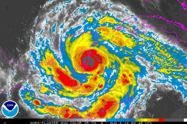
It is a curious structure compared to satellite, though.
0 likes   

ozonepete
Professional-Met
Professional-Met
Posts: 4743
Joined: Mon Sep 07, 2009 3:23 pm
Location: From Ozone Park, NYC / Now in Brooklyn, NY

Re: ATL: ERNESTO - Hurricane

#4557 Postby ozonepete » Tue Aug 07, 2012 11:02 pm

timmeister wrote:
ozonepete wrote:
timmeister wrote:Looks like he's still intensifying with the center onshore.

http://i49.tinypic.com/116n8r5.gif


No. The center is filling in. It's definitely weakening now.


So why are the areas of deep convection expanding in size?


That's what always happens as the center comes onshore. Land friction causes the surface winds to turn inward toward the center. The center fills in with surface air and the thunderstorms in the ring around it start losing intensity. The thunderstorms further out from the center hang onto their intensity longer so it looks like an expanding ring as each inward ring of thunderstorms collapses.
0 likes   

User avatar
Hurricane Alexis
Category 2
Category 2
Posts: 683
Age: 29
Joined: Thu Jun 14, 2012 7:59 pm
Location: Miami,Florida

#4558 Postby Hurricane Alexis » Wed Aug 08, 2012 1:01 am

000
WTNT35 KNHC 080543
TCPAT5

BULLETIN
HURRICANE ERNESTO INTERMEDIATE ADVISORY NUMBER 27A
NWS NATIONAL HURRICANE CENTER MIAMI FL AL052012
100 AM CDT WED AUG 08 2012

...ERNESTO MOVING INLAND OVER THE SOUTHERN PORTION OF THE
YUCATAN PENINSULA...


SUMMARY OF 100 AM CDT...0600 UTC...INFORMATION
----------------------------------------------
LOCATION...18.8N 88.3W
ABOUT 20 MI...35 KM N OF CHETUMAL MEXICO
ABOUT 160 MI...260 KM ESE OF CAMPECHE MEXICO
MAXIMUM SUSTAINED WINDS...80 MPH...130 KM/H
PRESENT MOVEMENT...W OR 270 DEGREES AT 15 MPH...24 KM/H
MINIMUM CENTRAL PRESSURE...983 MB...29.03 INCHES


WATCHES AND WARNINGS
--------------------
CHANGES WITH THIS ADVISORY...

NONE.

SUMMARY OF WATCHES AND WARNINGS IN EFFECT...

A HURRICANE WARNING IS IN EFFECT FOR...
* CHETUMAL TO TULUM ON THE EAST COAST OF THE YUCATAN PENINSULA
* COZUMEL
* COAST OF BELIZE FROM BELIZE CITY NORTHWARD TO THE BORDER OF MEXICO

A HURRICANE WATCH IS IN EFFECT FOR...
* BARRA DE NAUTLA TO PUNTA EL LAGARTO MEXICO

A TROPICAL STORM WARNING IS IN EFFECT FOR...
* NORTH OF TULUM TO CABO CATOCHE ON THE EAST COAST OF THE YUCATAN
PENINSULA
* SOUTH OF BELIZE CITY SOUTHWARD TO THE BORDER OF GUATEMALA
* CELESTUN SOUTHWARD AND WESTWARD TO CHILITEPEC ALONG THE GULF COAST
OF MEXICO

A TROPICAL STORM WATCH IS IN EFFECT FOR...
* NORTH OF BARRA DE NAUTLA TO TUXPAN MEXICO

A HURRICANE WATCH MEANS THAT HURRICANE CONDITIONS ARE POSSIBLE
WITHIN THE WATCH AREA. A WATCH IS TYPICALLY ISSUED 48 HOURS
BEFORE THE ANTICIPATED FIRST OCCURRENCE OF TROPICAL-STORM-FORCE
WINDS...CONDITIONS THAT MAKE OUTSIDE PREPARATIONS DIFFICULT OR
DANGEROUS.

A TROPICAL STORM WATCH MEANS THAT TROPICAL STORM CONDITIONS ARE
POSSIBLE WITHIN THE WATCH AREA...GENERALLY WITHIN 48 HOURS.

FOR STORM INFORMATION SPECIFIC TO YOUR AREA...PLEASE MONITOR
PRODUCTS ISSUED BY YOUR NATIONAL METEOROLOGICAL SERVICE.


DISCUSSION AND 48-HOUR OUTLOOK
------------------------------
AT 100 AM CDT...0600 UTC...THE CENTER OF HURRICANE ERNESTO WAS
LOCATED BY THE BELIZE DOPPLER RADAR TO BE NEAR LATITUDE 18.8
NORTH...LONGITUDE 88.3 WEST. ERNESTO IS MOVING TOWARD THE WEST
NEAR 15 MPH...24 KM/H...THIS GENERAL MOTION IS EXPECTED TO CONTINUE
DURING THE NEXT DAY OR SO. ON THE FORECAST TRACK...THE CENTER
OF ERNESTO WILL MOVE ACROSS THE SOUTHERN PORTIONS OF THE YUCATAN
PENINSULA THIS MORNING...AND EMERGE OVER THE BAY OF CAMPECHE THIS
AFTERNOON.

MAXIMUM SUSTAINED WINDS HAVE DECREASED TO NEAR 80 MPH...130 KM/H...
WITH HIGHER GUSTS. ERNESTO IS A CATEGORY ONE HURRICANE ON THE
SAFFIR-SIMPSON HURRICANE WIND SCALE. WEAKENING IS EXPECTED AS
ERNESTO MOVES OVER LAND THIS MORNING. RESTRENGTHENING IS FORECAST
AFTER ERNESTO EMERGES OVER THE BAY OF CAMPECHE.

HURRICANE-FORCE WINDS EXTEND OUTWARD UP TO 35 MILES...55 KM...FROM
THE CENTER...AND TROPICAL-STORM-FORCE WINDS EXTEND OUTWARD UP TO 175
MILES...280 KM.

ESTIMATED MINIMUM CENTRAL PRESSURE IS 983 MB...29.03 INCHES.


HAZARDS AFFECTING LAND
----------------------
WIND...HURRICANE CONDITIONS WILL CONTINUE TO SPREAD INLAND OVER
PORTIONS OF THE SOUTHERN YUCATAN PENINSULA THIS MORNING. TROPICAL
STORM CONDITIONS ARE EXPECTED ALONG PORTIONS OF THE GULF COAST OF
MEXICO IN THE TROPICAL STORM WARNING AREA BY LATER THIS MORNING.
HURRICANE CONDITIONS ARE POSSIBLE IN THE HURRICANE WATCH AREA BY
THURSDAY AFTERNOON OR EVENING...WITH TROPICAL STORM CONDITIONS
POSSIBLE BY THURSDAY MORNING OR AFTERNOON.

RAINFALL...ERNESTO IS EXPECTED TO PRODUCE TOTAL RAINFALL
ACCUMULATIONS OF 3 TO 5 INCHES ALONG THE NORTHERN COAST OF
HONDURAS...WITH ISOLATED MAXIMUM AMOUNTS OF 8 INCHES OVER
MOUNTAINOUS TERRAIN. TOTAL RAINFALL ACCUMULATIONS OF 4 TO 8 INCHES
WITH ISOLATED MAXIMUM AMOUNTS OF 12 INCHES ARE POSSIBLE OVER
BELIZE...THE YUCATAN PENINSULA AND NORTHERN GUATEMALA. THESE
RAINS MAY PRODUCE LIFE THREATENING FLASH FLOODS AND MUD SLIDES OVER
HIGHER TERRAIN.

STORM SURGE...A DANGEROUS STORM SURGE OF AS MUCH AS 2 TO 4 FEET
ABOVE NORMAL TIDE LEVELS WILL CONTINUE EARLY THIS MORNING NEAR
WHERE ERNESTO MADE LANDFALL ALONG THE EAST COAST OF THE YUCATAN
PENINSULA. A STORM SURGE OF 1 TO 3 FEET ABOVE NORMAL TIDE LEVELS IS
LIKELY IN AREAS OF ONSHORE WINDS IN THE WARNING AREA ALONG THE GULF
COAST OF MEXICO. NEAR THE COAST...THE SURGE WILL BE ACCOMPANIED BY
LARGE AND DANGEROUS WAVES.


NEXT ADVISORY
-------------
NEXT COMPLETE ADVISORY...400 AM CDT.

$$
FORECASTER BROWN/ROBERTS
0 likes   
Personal Forecast Disclaimer:
The posts in this forum are NOT official forecast and should not be used as such. They are just the opinion of the poster and may or may not be backed by sound meteorological data. They are NOT endorsed by any professional institution or storm2k.org. For official information, please refer to the NHC and NWS products.

User avatar
Hammy
Category 5
Category 5
Posts: 5849
Age: 41
Joined: Fri May 25, 2012 5:25 pm
Contact:

#4559 Postby Hammy » Wed Aug 08, 2012 2:17 am

its weakened probably but become better organized at the same time as the eye is now clearly visible on satellite :eek:
0 likes   
The above post is not official and should not be used as such. It is the opinion of the poster and may or may not be backed by sound meteorological data. It is not endorsed by any professional institution or storm2k.org. For official information, please refer to the NHC and NWS products.

User avatar
beoumont
Category 1
Category 1
Posts: 473
Joined: Sun Jul 10, 2011 4:13 pm
Location: East Central Florida
Contact:

Re: ATL: ERNESTO - Hurricane

#4560 Postby beoumont » Wed Aug 08, 2012 3:36 am

On several past occasions when hurricanes have passed over Yucatan and come back over the Bay of Canned Peaches, the eye when it emerges is 50-180 miles wide. Let's see if this happens again.
0 likes   
List of 79 tropical cyclones intercepted by Richard Horodner:
http://www.canebeard.com/page/page/572246.htm


Return to “2012”

Who is online

Users browsing this forum: No registered users and 7 guests