According to the GFS, if that long fetch of South, then Southwest wind, cities like Mandeville and Slidell, on the northshore of Lake Pontchartrain, could be under water.
This is not an official forecast, jmho based on the time the GFS is showing the storm parallel the coast.
ATL: ISAAC - Models
Moderator: S2k Moderators
-
Pearl River

- S2K Supporter

- Posts: 825
- Age: 66
- Joined: Fri Dec 09, 2005 6:07 pm
- Location: SELa
Re: ATL: ISAAC - Models
0 likes
-
Hurricaneman

- Category 5

- Posts: 7404
- Age: 45
- Joined: Tue Aug 31, 2004 3:24 pm
- Location: central florida
Re: ATL: ISAAC - Models
Javlin wrote:ridge breaks @66hrs look to go NE

Nope, gets caught under the ridge and looks like its headed for Beaumont, there is a fork in the roads situation, GFS gets caught by the ridge and heads west while the Euro heads north through the trough, its a really close call as to which is right
The posts in this forum are NOT official forecast and should not be used as such. They are just the opinion of the poster and may or may not be backed by sound meteorological data. They are NOT endorsed by any professional institution or storm2k.org. For official information, please refer to the NHC and NWS products
0 likes
-
thatwhichisnt
- Tropical Depression

- Posts: 85
- Joined: Sat Aug 25, 2012 7:12 pm
Re: ATL: ISAAC - Models
The rain totals will be sickening. It will sit on top of south la for days
Sent from my HTC One X using Tapatalk 2
Sent from my HTC One X using Tapatalk 2
0 likes

Re: ATL: ISAAC - Models
After that it's fully inland and going up east Texas. Wnw

Last edited by Ntxw on Sun Aug 26, 2012 11:04 am, edited 1 time in total.
0 likes
The above post and any post by Ntxw is NOT an official forecast and should not be used as such. It is just the opinion of the poster and may or may not be backed by sound meteorological data. It is NOT endorsed by any professional institution including Storm2k. For official information, please refer to NWS products.
Help support Storm2K!

-
Portastorm

- Storm2k Moderator

- Posts: 9914
- Age: 63
- Joined: Fri Jul 11, 2003 9:16 am
- Location: Round Rock, TX
- Contact:
Re: ATL: ISAAC - Models
Isaac looks to finally be picked up by the westerlies at H-105 and lifting north through east Texas.
0 likes
Any forecasts under my name are to be taken with a grain of salt. Get your best forecasts from the National Weather Service and National Hurricane Center.

wow....so se texas is in play according to gfs.... and the west trend continues
Personal Forecast Disclaimer:
The posts in this forum are NOT official forecast and should not be used as such. They are just the opinion of the poster and may or may not be backed by sound meteorological data. They are NOT endorsed by any professional institution or storm2k.org. For official information, please refer to the NHC and NWS products.
0 likes
-
BigB0882
- S2K Supporter
- Posts: 2285
- Joined: Thu Jul 03, 2003 12:08 am
- Location: Baton Rouge, LA
- Contact:
Re: ATL: ISAAC - Models
Stormlover2012 wrote:this is more west this run
Hardly at all. It rides along the LA coast exactly as the last run did. The only difference is it starts to life up around Lake Charles in the 6z run but in this run it gets to Beaumont before doing so. All the same areas are affected as before, just some places (like Beaumont) would get hit harder this run. IMO.
0 likes
-
wxwatcher1999
- Category 1

- Posts: 264
- Joined: Sat Aug 04, 2012 10:19 am
ok i am going to fill gas tank up today here in Port Arthur
0 likes
Personal Forecast Disclaimer:
The posts in this forum are NOT official forecast and should not be used as such. They are just the opinion of the poster and may or may not be backed by sound meteorological data. They are NOT endorsed by any professional institution or storm2k.org. For official information, please refer to the NHC and NWS products.
The posts in this forum are NOT official forecast and should not be used as such. They are just the opinion of the poster and may or may not be backed by sound meteorological data. They are NOT endorsed by any professional institution or storm2k.org. For official information, please refer to the NHC and NWS products.
-
Dean4Storms
- S2K Supporter
- Posts: 6358
- Age: 62
- Joined: Sun Aug 31, 2003 1:01 pm
- Location: Miramar Bch. FL

Re: ATL: ISAAC - Models
That's a dismal run for the city. Water piles up along the coast and funnels (sp?) into lake pontchartrain through lake borgne and the rigolets. Meanwhile, strong ne winds ahead of the storm pile lake waters on the southshore. We have the best protection we have ever had, and the Mississippi river gulf outlet is now closed. BUT nothing has been tested yet. Any levee failures could mean a similar situation to 2005. Making things worse, the westbank of nola was relatively unscathed as was the bayou (lafourche and tetrebonne parishes.) so many of us shacked up with friends and family in those areas and were still able to work on our lives and houses from a 50 mile radius. Katrina faded east of the city. Isaac, in the 12z run does not. So other areas could potentially be in trouble if this verifies. A little known fact during Ike, which passed 100 miles south of the sc la coast, was that over ten thousand dwellings flooded in south tetrrbonne. We just don't have the wetlands to buffer Surges anymore. If things progress to where it appears this will verify, and I decide to stay, ill be moving the vehicles to a mid level floor in my CBD parking garage. Damn I don't feel like dealing with some of these possibilities again 
0 likes
-
Rgv20

- S2K Supporter
- Posts: 2466
- Age: 39
- Joined: Wed Jan 05, 2011 5:42 pm
- Location: Edinburg/McAllen Tx
A few of the 0zECMWF Ensembles seem to agree on a more western track....wont be surprised if today's 12 run trends to the west..
0zECMWF Ensemble Spread +120hrs
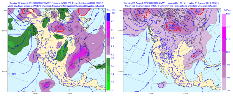
0zECMWF Ensemble Spread +120hrs
0 likes
The following post is NOT an official forecast and should not be used as such. It is just the opinion of the poster and may or may not be backed by sound meteorological data. It is NOT endorsed by any professional institution including storm2k.org For Official Information please refer to the NHC and NWS products.
-
wxwatcher1999
- Category 1
- Posts: 264
- Joined: Sat Aug 04, 2012 10:19 am
does anyone think the cone will be shifted west today and if they do so what time will that be?
0 likes
Personal Forecast Disclaimer:
The posts in this forum are NOT official forecast and should not be used as such. They are just the opinion of the poster and may or may not be backed by sound meteorological data. They are NOT endorsed by any professional institution or storm2k.org. For official information, please refer to the NHC and NWS products.
The posts in this forum are NOT official forecast and should not be used as such. They are just the opinion of the poster and may or may not be backed by sound meteorological data. They are NOT endorsed by any professional institution or storm2k.org. For official information, please refer to the NHC and NWS products.

Re: ATL: ISAAC - Models
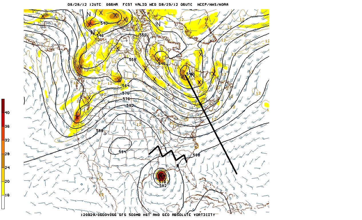
Shows trough axis (exaggerated southward) and the building/closing ridge over the SE.
0 likes
-
Jevo

- S2K Supporter
- Posts: 1729
- Age: 47
- Joined: Tue Aug 03, 2004 8:45 pm
- Location: The Flemish Cap
- Contact:
This afternoons G-IV flight for 0z model guidance

0 likes
Disclaimer: 50% of the time I have no clue of what I am talking about. Chances are I am taking a less than educated guess that sounds good because 10 years ago I stole Mike Watkins book 'The Hurricane and its Impact'. For official information please direct yourself to the NHC and their cadre of weather geniuses.

Re: ATL: ISAAC - Models
I have been saying it for days now...Euro sniffed out western solution first, we saw stalls near the coast and now we are seeing the progression..upper Texas coast better be paying attention!!!
0 likes
-
HurricaneBrain

- S2K Supporter
- Posts: 520
- Joined: Thu Jun 30, 2011 2:07 pm
-
Hurricane Cheese

- Category 1
- Posts: 365
- Joined: Thu Aug 12, 2004 12:40 am
- Location: Green Bay, WI (UWGB Earth Science Alum)
Re: ATL: ISAAC - Models
Hurricane center has 11 AM track over Mississippi coastline...have to believe that will shift to NOLA area for 5 pm based on latest GFS run. The westward shifts are obviously a trend, and the storm will spend the better part of the next three days over the gulf gathering strength. Emergency managers really need to get things going today IMO as you can't order a full scale evacuation of NOLA tomorrow and allow for adequate time to get everyone out.
I would hope and expect we should be hearing from Governor Jindahl sooner rather than later today regarding this growing threat....
I would hope and expect we should be hearing from Governor Jindahl sooner rather than later today regarding this growing threat....
0 likes
"If we are afraid to be different...how can we make a difference in the world?"
- Rev. John I. Jenkins C.S.C, President, University of Notre Dame
- Rev. John I. Jenkins C.S.C, President, University of Notre Dame
Re: ATL: ISAAC - Models
Senobia wrote:I missed the forecast intensity on these TX/LA runs. Anyone know?
cat 2-3
Personal Forecast Disclaimer:
The posts in this forum are NOT official forecast and should not be used as such. They are just the opinion of the poster and may or may not be backed by sound meteorological data. They are NOT endorsed by any professional institution or storm2k.org. For official information, please refer to the NHC and NWS products.
0 likes
Who is online
Users browsing this forum: No registered users and 45 guests