ATL: LESLIE - Post-Tropical - Discussion

Moderator: S2k Moderators

Message
Author
ozonepete
Professional-Met
Professional-Met
Posts: 4743
Joined: Mon Sep 07, 2009 3:23 pm
Location: From Ozone Park, NYC / Now in Brooklyn, NY

Re: ATL: LESLIE - Tropical Storm - Discussion

#521 Postby ozonepete » Fri Aug 31, 2012 8:12 pm

Luis, thanks so much for that F-18 microwave. I would miss Hurakan even more if not for you. :)

For anyone who doesn't know what that microwave satellite Luis posted a little while ago rpresents, that's a 37GHz microwave which "sees" circulations just above the surface. That's why you don't "see" the heavy convection and clouds above and all around the center at higher levels. It's an awesome satellite for finding the LLC.

Now since that showed us the LLC at 2315 UTC, and we have a classic avn satellite image from that time, we can pinpoint the LLC under the convection at that time. Here it is:

Image

Don't think I was that far off, and sure looks like the LLC and MLC are consolidating...
Last edited by ozonepete on Fri Aug 31, 2012 8:14 pm, edited 2 times in total.
0 likes   

HurricaneAndrew92

Re: ATL: LESLIE - Tropical Storm - Discussion

#522 Postby HurricaneAndrew92 » Fri Aug 31, 2012 8:12 pm

In the final forecast point, Leslie turns west.
0 likes   

Hey Its Me
Tropical Storm
Tropical Storm
Posts: 162
Joined: Thu Aug 30, 2012 5:49 pm

Re: ATL: LESLIE - Tropical Storm - Discussion

#523 Postby Hey Its Me » Fri Aug 31, 2012 8:13 pm

cycloneye wrote:I hope that in the near future QuickScat is back to not only depend on a microwave. :)


RIP QuickScat. Anyone hear if they are ever going to put a new satellite up? From what I've read the project/idea is DOA. Seems like Gonzo feeding DS data back to the models is the current strategy.
0 likes   

User avatar
tropicwatch
Category 5
Category 5
Posts: 3383
Age: 61
Joined: Sat Jun 02, 2007 10:01 am
Location: Panama City Florida
Contact:

#524 Postby tropicwatch » Fri Aug 31, 2012 8:21 pm

Hope she makes that northward turn soon. The islands are now in the sat pic. :(
0 likes   
Tropicwatch


Agnes 72', Eloise 75, Elena 85', Kate 85', Charley 86', Florence 88', Beryl 94', Dean 95', Erin 95', Opal 95', Earl 98', Georges 98', Ivan 2004', Arlene 2005', Dennis 2005', Ida 2009' Debby 2012' Irma 2017' Michael 2018'

User avatar
cycloneye
Admin
Admin
Posts: 145305
Age: 68
Joined: Thu Oct 10, 2002 10:54 am
Location: San Juan, Puerto Rico

Re:

#525 Postby cycloneye » Fri Aug 31, 2012 8:27 pm

panamatropicwatch wrote:Hope she makes that northward turn soon. The islands are now in the sat pic. :(


And many mention a key position 20N-60W. Interesting things going on tonight with the system.
0 likes   
Visit the Caribbean-Central America Weather Thread where you can find at first post web cams,radars
and observations from Caribbean basin members Click Here

ozonepete
Professional-Met
Professional-Met
Posts: 4743
Joined: Mon Sep 07, 2009 3:23 pm
Location: From Ozone Park, NYC / Now in Brooklyn, NY

Re: Re:

#526 Postby ozonepete » Fri Aug 31, 2012 8:28 pm

cycloneye wrote:
panamatropicwatch wrote:Hope she makes that northward turn soon. The islands are now in the sat pic. :(


And many mention a key position 20N-60W. Interesting things going on tonight with the system.


Yeah, for sure. Leslie better start turning soon. It's getting late. :(
0 likes   

User avatar
Cyclenall
Category 5
Category 5
Posts: 6666
Joined: Thu Jun 08, 2006 10:01 pm
Location: Ontario, Canada

Re:

#527 Postby Cyclenall » Fri Aug 31, 2012 8:32 pm

Leslie looks amazing today, one of the best looking TS's of the year. It has that perfect appearance whether or not the LLC is at the center. I was thinking how great and fast its intensifying and then I read the NHC discussion and they downplay it. Even the mention of the intensity being backed off! Now only a CAT1?!? I was just thinking this was going to explode into a CAT3-4! I don't remember a discussion talking about a "upper level high" (don't really know how that plays into things) but with them mentioning this, it probably will end up being 0 shear instead...its the opposite usually in the beginning of forecasts for a early period of TCs (unexpected both ways like Issac having shear and Kirk having no shear). As I said in the Kirk topic, if this doesn't become a major...well what will?

Zanthe wrote:Guys, if you think this is the first good looking system, or first system that's gone through RI...*cough* Gordon *cough* Kirk *Cough*

I think they mean best looking TS of the season.

cycloneye wrote:No change on intensity and center is at 17.1N.

00z Best Track

AL, 12, 2012090100, , BEST, 0, 171N, 520W, 55, 999, TS

ftp://ftp.nhc.noaa.gov/atcf/tcweb/inves ... 012.invest

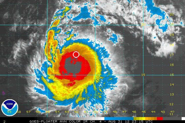
You never know, it might be a hurricane right now but until that eye pops out, no dice.

wxman57 wrote:Yeah, looks good if the center was in the middle of the deep convection, but it isn't. I believe it's on the northern edge of that convection. Still fighting NE shear. Not a hurricane.

Edit:
Ah, yes - see the microwave image above this post. Satellite imagery can be QUITE deceiving.

It doesn't look like its fighting anything. It doesn't need 0 knots of wind shear to organize quickly. That microwave image shows an eye forming, that white grid line is covering it up making it difficult to see.
0 likes   

User avatar
edurican
Tropical Wave
Tropical Wave
Posts: 6
Joined: Fri Aug 31, 2012 12:27 pm
Location: San Juan, PR

Re: Re:

#528 Postby edurican » Fri Aug 31, 2012 8:32 pm

ozonepete wrote:
cycloneye wrote:
panamatropicwatch wrote:Hope she makes that northward turn soon. The islands are now in the sat pic. :(


And many mention a key position 20N-60W. Interesting things going on tonight with the system.


Yeah, for sure. Leslie better start turning soon. It's getting late. :(


I'm worried that this thing ends up not turning and catching everyone off guard. Here in PR people don't even know this storm is this close.
0 likes   
I'm not a meteorologist, not even close. Please don't rely on what I say about the weather!

ozonepete
Professional-Met
Professional-Met
Posts: 4743
Joined: Mon Sep 07, 2009 3:23 pm
Location: From Ozone Park, NYC / Now in Brooklyn, NY

Re: Re:

#529 Postby ozonepete » Fri Aug 31, 2012 8:38 pm

edurican wrote:I'm worried that this thing ends up not turning and catching everyone off guard. Here in PR people don't even know this storm is this close.


Let's just keep watching and wait for the 11PM NHC advisory. Although it should have turned more northwest by now, no one is more on top of this than the NHC. Let's see what they say. If people on the islands need to be alerted, they will let you know. Meanwhile don't worry my friend. I admit I'm as curious as you are. :)
0 likes   

User avatar
Cyclenall
Category 5
Category 5
Posts: 6666
Joined: Thu Jun 08, 2006 10:01 pm
Location: Ontario, Canada

Re: Re:

#530 Postby Cyclenall » Fri Aug 31, 2012 8:43 pm

ozonepete wrote:
edurican wrote:I'm worried that this thing ends up not turning and catching everyone off guard. Here in PR people don't even know this storm is this close.


Let's just keep watching and wait for the 11PM NHC advisory. Although it should have turned more northwest by now, no one is more on top of this than the NHC. Let's see what they say. If people on the islands need to be alerted, they will let you know. Meanwhile don't worry my friend. I admit I'm as curious as you are. :)

Would it not be unprecedented if Leslie were to not turn at all within the short term? Its basically unheard of for a TC to not turn when it was expected to do so in the very short term...like 24-36 hours. Many decades ago I'm sure it could have happened.
0 likes   

ozonepete
Professional-Met
Professional-Met
Posts: 4743
Joined: Mon Sep 07, 2009 3:23 pm
Location: From Ozone Park, NYC / Now in Brooklyn, NY

Re: Re:

#531 Postby ozonepete » Fri Aug 31, 2012 8:50 pm

Cyclenall wrote:
ozonepete wrote:
edurican wrote:I'm worried that this thing ends up not turning and catching everyone off guard. Here in PR people don't even know this storm is this close.


Let's just keep watching and wait for the 11PM NHC advisory. Although it should have turned more northwest by now, no one is more on top of this than the NHC. Let's see what they say. If people on the islands need to be alerted, they will let you know. Meanwhile don't worry my friend. I admit I'm as curious as you are. :)

Would it not be unprecedented if Leslie were to not turn at all within the short term? Its basically unheard of for a TC to not turn when it was expected to do so in the very short term...like 24-36 hours. Many decades ago I'm sure it could have happened.


It used to happen 20 years or so ago and further back, but it would be really, really unusual if it happened now. I can't think of a model fail that big since then. Let's hope it will just make a sharper turn, but it really looks like it isn't. I'm very curious what the 11PM will say. Very unusual.
0 likes   

User avatar
drezee
S2K Supporter
S2K Supporter
Posts: 3664
Joined: Mon Jun 09, 2003 12:49 pm
Location: FL

Re: ATL: LESLIE - Tropical Storm - Discussion

#532 Postby drezee » Fri Aug 31, 2012 8:50 pm

The MLC is clear on the 2115 IR image to the SW of the microwave center LLC. Bursting maybe in her future.
0 likes   

ozonepete
Professional-Met
Professional-Met
Posts: 4743
Joined: Mon Sep 07, 2009 3:23 pm
Location: From Ozone Park, NYC / Now in Brooklyn, NY

Re: ATL: LESLIE - Tropical Storm - Discussion

#533 Postby ozonepete » Fri Aug 31, 2012 8:59 pm

Most curious is why neither the MLC or the LLC are starting the recurve.

Wxman57 do you see it?
0 likes   

User avatar
fci
S2K Supporter
S2K Supporter
Posts: 3324
Joined: Tue Sep 14, 2004 10:29 am
Location: Lake Worth, FL

Re: ATL: LESLIE - Tropical Storm - Discussion

#534 Postby fci » Fri Aug 31, 2012 9:03 pm

ozonepete wrote:
Riptide wrote:
ozonepete wrote:A stall for 6 days? That hasn't been done before, at least in recorded meteorological history.


Yes, Inga in 1969 stalled for eight (8) days in that area.

Wow, that's crazy. It's a shame I wasn't alive to see it. There seems to be an ideal forward speed for tropical cyclones as most stalled cyclones do not become very strong.

http://upload.wikimedia.org/wikipedia/c ... _track.png


Yeah! That was the first season I ever tracked hurricanes. I was a young kid and tracked them on a little paper map with a pencil making dots and connecting them. You had to listen to the radio and watch the TV weather and pray really hard they'd give a location. When they actually gave co-ordinates you were in heaven. That being the first time I ever followed them I had no idea how unusual it was; I thought a lot of hurricanes did that, lol![/quote]

I remember those days!!!!
I'm old..... :cry:
0 likes   

User avatar
Fego
S2K Supporter
S2K Supporter
Posts: 767
Age: 65
Joined: Sun Apr 18, 2004 7:58 pm
Location: San Juan, Puerto Rico
Contact:

Re: ATL: LESLIE - Tropical Storm - Discussion

#535 Postby Fego » Fri Aug 31, 2012 9:15 pm

Looking at this image from Intellicast, I just keep thinking: "so close and yet so far".

Image

Uploaded with ImageShack.us
0 likes   
Go Giants! Go Niners! Go Warriors!

User avatar
cycloneye
Admin
Admin
Posts: 145305
Age: 68
Joined: Thu Oct 10, 2002 10:54 am
Location: San Juan, Puerto Rico

Re: ATL: LESLIE - Tropical Storm - Discussion

#536 Postby cycloneye » Fri Aug 31, 2012 9:19 pm

That is where ADT puts the center. And the weakening flag is on.

http://tropic.ssec.wisc.edu/real-time/adt/odt12L.html

Image
0 likes   
Visit the Caribbean-Central America Weather Thread where you can find at first post web cams,radars
and observations from Caribbean basin members Click Here

08lava
Tropical Wave
Tropical Wave
Posts: 7
Joined: Sat Sep 03, 2011 8:22 pm
Location: Cedar Park (Austin), Texas

Re: ATL: LESLIE - Tropical Storm - Discussion

#537 Postby 08lava » Fri Aug 31, 2012 9:19 pm

Leslie is looking impressive. Don't think it will be a GOM storm but weirder things have happened.. :double:
0 likes   
Carla 61, Alicia 83

The posts in this forum are NOT official forecast and should not be used as such. They are just the opinion of the poster and may or may not be backed by sound meteorological data. They are NOT endorsed by any professional institution or storm2k.org. For official information, please refer to the NHC and NWS products.

WilmingtonSandbar
S2K Supporter
S2K Supporter
Posts: 505
Joined: Sun Aug 29, 2010 12:11 pm
Location: Southport, NC

Re: ATL: LESLIE - Tropical Storm - Discussion

#538 Postby WilmingtonSandbar » Fri Aug 31, 2012 9:25 pm

sandyb wrote:
WilmingtonSandbar wrote:
sandyb wrote:I know its to early to tell but everyone keeps talking about Florida what about NC anyones thoughts on what you think of it getting into our coast or close?


I'm getting that gitchy feeling down here. That one I always get about a week before a storm comes really close to me.


we for sure don't need a storm with as much rain as we have had the past two week here in Carteret Co my yard is still under water is places


Same here in Brunswick County. It rained everyday for 3 weeks up until Thursday. I can't remember the last time we got this much rain in the summer.
0 likes   
Diana X2 (look it up), Bertha, Fran, Bonnie, Floyd, Dennis, Charley, Ophelia, Ernesto, Irene, Matthew, And Florence

crimi481
Category 2
Category 2
Posts: 602
Joined: Thu Sep 09, 2004 4:47 pm

Re: ATL: LESLIE - Tropical Storm - Discussion

#539 Postby crimi481 » Fri Aug 31, 2012 9:27 pm

Ridge is building just north of it - staying in front of it as it goes W. Looks like ridge is strong
http://www.ssd.noaa.gov/goes/east/tatl/flash-bd.html
0 likes   

User avatar
Hurricane Alexis
Category 2
Category 2
Posts: 683
Age: 29
Joined: Thu Jun 14, 2012 7:59 pm
Location: Miami,Florida

Re: ATL: LESLIE - Tropical Storm - Discussion

#540 Postby Hurricane Alexis » Fri Aug 31, 2012 9:28 pm

cycloneye wrote:That is where ADT puts the center. And the weakening flag is on.

http://tropic.ssec.wisc.edu/real-time/adt/odt12L.html

http://oi46.tinypic.com/2hqrrlc.jpg


If it really is on the northern side of the circulation then it isn't as impressive as it looks.
0 likes   
Personal Forecast Disclaimer:
The posts in this forum are NOT official forecast and should not be used as such. They are just the opinion of the poster and may or may not be backed by sound meteorological data. They are NOT endorsed by any professional institution or storm2k.org. For official information, please refer to the NHC and NWS products.


Return to “2012”

Who is online

Users browsing this forum: No registered users and 6 guests