ATL: ISAAC - Post-Tropical - Discussion

Moderator: S2k Moderators

Message
Author
WilmingtonSandbar
S2K Supporter
S2K Supporter
Posts: 505
Joined: Sun Aug 29, 2010 12:11 pm
Location: Southport, NC

Re: ATL: ISAAC - Tropical Storm - Discussion

#5281 Postby WilmingtonSandbar » Sun Aug 26, 2012 5:57 pm

mahi1720 wrote:Give it a few hrs. and you're gonna see an eyewall. It's about to bomb out. This reminds me of Charley.


What evidence do you have to support your prediction?
0 likes   
Diana X2 (look it up), Bertha, Fran, Bonnie, Floyd, Dennis, Charley, Ophelia, Ernesto, Irene, Matthew, And Florence

User avatar
stormhunter7
Category 2
Category 2
Posts: 762
Joined: Mon May 26, 2008 3:13 pm
Location: Panama City Beach, Florida
Contact:

Re: ATL: ISAAC - Tropical Storm - Discussion

#5282 Postby stormhunter7 » Sun Aug 26, 2012 5:57 pm

Aric Dunn wrote:
rainstorm wrote:
bella_may wrote:I don't think that's the center you guys are seeing drift west. The center is east of there


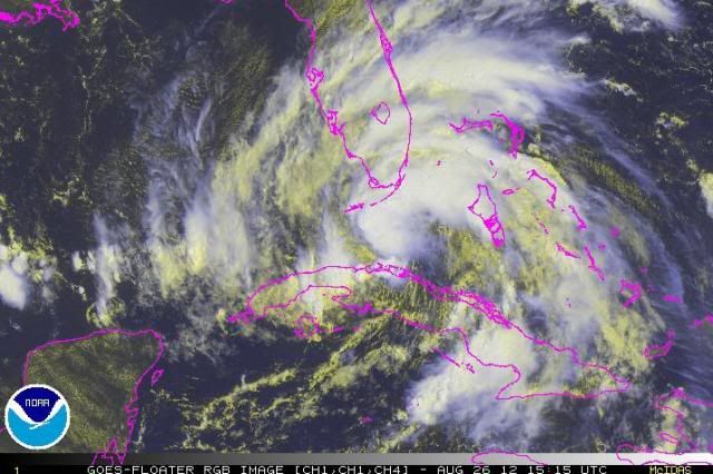
its not a good sign when no one can figure out where the center is.


we know exactly where the center is... recon just passed through it :)


basically per Kermit its near Time: 22:20:30Z Coordinates: 23.95N 82.4667W... they dropped two dropsondes... one on east side and other on west side of coc. Pressure around 992mb
0 likes   
The following post is NOT an official forecast and should not be used as such. It is just the opinion of the poster and may or may not be backed by sound meteorological data. It is NOT endorsed by any professional institution including storm2k.org For Official Information please refer to the NHC and NWS products. http://www.nhc.noaa.gov

cpdaman
Category 5
Category 5
Posts: 3131
Joined: Sat Jun 10, 2006 11:44 am
Location: SPB county (gulf stream)

Re: ATL: ISAAC - Tropical Storm - Discussion

#5283 Postby cpdaman » Sun Aug 26, 2012 5:58 pm

Aric or wxman57 or anyone lol are mid level temps in the se gulf / cent. Gulf still modeled to be rather warm (less instability) this is imo a reason for reserv'd intensity forecasts
0 likes   

mahi1720
Tropical Wave
Tropical Wave
Posts: 6
Joined: Wed Aug 22, 2012 4:20 pm

Re: ATL: ISAAC - Tropical Storm - Discussion

#5284 Postby mahi1720 » Sun Aug 26, 2012 5:58 pm

Look at that CDO in the last 2 hrs. There's a consolidated low under it, relatively low shear,and 90dg. water. It's cranking.
0 likes   

WilmingtonSandbar
S2K Supporter
S2K Supporter
Posts: 505
Joined: Sun Aug 29, 2010 12:11 pm
Location: Southport, NC

Re:

#5285 Postby WilmingtonSandbar » Sun Aug 26, 2012 5:59 pm

HurricaneBrain wrote:Isaac's about to explode.


What evidence do you have to support your prediction?
0 likes   
Diana X2 (look it up), Bertha, Fran, Bonnie, Floyd, Dennis, Charley, Ophelia, Ernesto, Irene, Matthew, And Florence

User avatar
N2FSU
S2K Supporter
S2K Supporter
Posts: 1063
Joined: Thu Sep 04, 2003 2:04 pm
Location: Tallahassee, FL

Re: ATL: ISAAC - Tropical Storm - Discussion

#5286 Postby N2FSU » Sun Aug 26, 2012 5:59 pm

Question for someone smarter than me: would a slower motion make it more or less likely that it makes the connection with the trough which is moving towards the southeast? I can't figure out if the GFS is sticking to a further west solution because Isaac gets to the coast too fast before the trough gets very far east, or does the trough simply not dig far enough south to catch it? If it's a matter of the first, then I would think it slowing and waiting on the trough, so to speak, would make it more likely to follow more of the Euro, CMC, NAM solutions.
0 likes   

bella_may
Category 4
Category 4
Posts: 908
Joined: Wed Dec 22, 2010 2:13 pm
Location: SE Mississippi coast

Re: ATL: ISAAC - Tropical Storm - Discussion

#5287 Postby bella_may » Sun Aug 26, 2012 6:02 pm

N2FSU wrote:Question for someone smarter than me: would a slower motion make it more or less likely that it makes the connection with the trough which is moving towards the southeast? I can't figure out if the GFS is sticking to a further west solution because Isaac gets to the coast too fast before the trough gets very far east, or does the trough simply not dig far enough south to catch it? If it's a matter of the first, then I would think it slowing and waiting on the trough, so to speak, would make it more likely to follow more of the Euro, CMC, NAM solutions.

I would say more likely because the slower it moves the faster the trough can send it north/NE. I'm not a professional though.
0 likes   

User avatar
stormhunter7
Category 2
Category 2
Posts: 762
Joined: Mon May 26, 2008 3:13 pm
Location: Panama City Beach, Florida
Contact:

Re: ATL: ISAAC - Tropical Storm - Discussion

#5288 Postby stormhunter7 » Sun Aug 26, 2012 6:03 pm

Mid level center and surface center appear to be off by a little. I'm thinking this slower motion is the mid-upper center is trying to pull the surface center more to the north, while moving nw
0 likes   
The following post is NOT an official forecast and should not be used as such. It is just the opinion of the poster and may or may not be backed by sound meteorological data. It is NOT endorsed by any professional institution including storm2k.org For Official Information please refer to the NHC and NWS products. http://www.nhc.noaa.gov

Aric Dunn
Category 5
Category 5
Posts: 21238
Age: 42
Joined: Sun Sep 19, 2004 9:58 pm
Location: Ready for the Chase.
Contact:

Re: ATL: ISAAC - Tropical Storm - Discussion

#5289 Postby Aric Dunn » Sun Aug 26, 2012 6:03 pm

N2FSU wrote:Question for someone smarter than me: would a slower motion make it more or less likely that it makes the connection with the trough which is moving towards the southeast? I can't figure out if the GFS is sticking to a further west solution because Isaac gets to the coast too fast before the trough gets very far east, or does the trough simply not dig far enough south to catch it? If it's a matter of the first, then I would think it slowing and waiting on the trough, so to speak, would make it more likely to follow more of the Euro, CMC, NAM solutions.


well based on the fact the gfs is quite a bit faster than the euro i would say thats the case atm but its hard to tell. also the euro has a more pronounced 500mb vorticity and this feels the weakness more. so we will just have to wait and see... this stalling is not making it easy to make a reliable forecast. no models foretasted this to happen
0 likes   
Note: If I make a post that is brief. Please refer back to previous posts for the analysis or reasoning. I do not re-write/qoute what my initial post said each time.
If there is nothing before... then just ask :)

Space & Atmospheric Physicist, Embry-Riddle Aeronautical University,
I believe the sky is falling...

Senobia
Category 1
Category 1
Posts: 278
Joined: Sat Aug 05, 2006 2:59 pm
Location: Somewhere over the rainbow

#5290 Postby Senobia » Sun Aug 26, 2012 6:04 pm

Updated 'action zones', from TWC:

Image
0 likes   

WilmingtonSandbar
S2K Supporter
S2K Supporter
Posts: 505
Joined: Sun Aug 29, 2010 12:11 pm
Location: Southport, NC

Re: ATL: ISAAC - Tropical Storm - Discussion

#5291 Postby WilmingtonSandbar » Sun Aug 26, 2012 6:05 pm

Nederlander wrote:
catskillfire51 wrote:I've been following this site since the Coast Guard stationed me down here in texas last year. It really is great information. I was trying to google some stuff I was reading on the discussion and I came across this. Hurricane isaac in 1900. I know Isaac is not forcasted to come to texas. Would be interesting if two Isaacs came close to the same landfall, both with the same forcasted category 4's. Sorry this isn't exactly related. Best wishes to anyone involved. :flag:

http://en.wikipedia.org/wiki/File:1900_ ... _track.png


Well technically the 1900 storm wasn't "Hurricane Isaac". Storms weren't named back then. It has been since nicknamed Isaac's storm after meteorologist Isaac Cline. But facts aside, I do see your point.


This was posted way back towards the beginning of this thread. It is a documentary about Isaac's storm, or the 1900 Galveston Hurricane. I found it interesting and informative. Glad we have come so far since then.

http://www.youtube.com/watch?v=5uz2GvDJHMg
0 likes   
Diana X2 (look it up), Bertha, Fran, Bonnie, Floyd, Dennis, Charley, Ophelia, Ernesto, Irene, Matthew, And Florence

rainstorm

Re: ATL: ISAAC - Tropical Storm - Discussion

#5292 Postby rainstorm » Sun Aug 26, 2012 6:05 pm

bella_may wrote:
N2FSU wrote:Question for someone smarter than me: would a slower motion make it more or less likely that it makes the connection with the trough which is moving towards the southeast? I can't figure out if the GFS is sticking to a further west solution because Isaac gets to the coast too fast before the trough gets very far east, or does the trough simply not dig far enough south to catch it? If it's a matter of the first, then I would think it slowing and waiting on the trough, so to speak, would make it more likely to follow more of the Euro, CMC, NAM solutions.

I would say more likely because the slower it moves the faster the trough can send it north/NE. I'm not a professional though.


i think one important thing is if there is anything for the trough to grab. if isaac remains shallow and disjointed it will move mostly west.
0 likes   

Aric Dunn
Category 5
Category 5
Posts: 21238
Age: 42
Joined: Sun Sep 19, 2004 9:58 pm
Location: Ready for the Chase.
Contact:

#5293 Postby Aric Dunn » Sun Aug 26, 2012 6:08 pm

very well could be that the upper/mid level low near the Yucatan is casue some mid level shear that is pushing the mid level vort to the ne which would cause the low level center to reform with it. I say that because there is some strong mid level rotation seen on radar withing the higher reflectivity.
0 likes   
Note: If I make a post that is brief. Please refer back to previous posts for the analysis or reasoning. I do not re-write/qoute what my initial post said each time.
If there is nothing before... then just ask :)

Space & Atmospheric Physicist, Embry-Riddle Aeronautical University,
I believe the sky is falling...

Sanibel
Category 5
Category 5
Posts: 10375
Joined: Mon Aug 30, 2004 11:06 pm
Location: Offshore SW Florida

Re: ATL: ISAAC - Tropical Storm - Discussion

#5294 Postby Sanibel » Sun Aug 26, 2012 6:10 pm

The CDO rotation has improved on radar.
0 likes   

mahi1720
Tropical Wave
Tropical Wave
Posts: 6
Joined: Wed Aug 22, 2012 4:20 pm

Re: ATL: ISAAC - Tropical Storm - Discussion

#5295 Postby mahi1720 » Sun Aug 26, 2012 6:11 pm

WilmingtonSandbar wrote:
mahi1720 wrote:Give it a few hrs. and you're gonna see an eyewall. It's about to bomb out. This reminds me of Charley.


What evidence do you have to support your prediction?

I can't state with 100% assurance but I do know we are in the peak of hurricane season, the water is hot and the Gulf of Mexico has had some hurricanes in the past. The conditions are pretty good. What evidence do you have that its not going to bomb?
0 likes   

User avatar
iorange55
Category 5
Category 5
Posts: 2388
Joined: Thu Nov 13, 2008 9:47 pm
Location: Big D

Re: ATL: ISAAC - Tropical Storm - Discussion

#5296 Postby iorange55 » Sun Aug 26, 2012 6:11 pm

WilmingtonSandbar wrote:
This was posted way back towards the beginning of this thread. It is a documentary about Isaac's storm, or the 1900 Galveston Hurricane. I found it interesting and informative. Glad we have come so far since then.

http://www.youtube.com/watch?v=5uz2GvDJHMg


Thanks for posting that; it gives me something to watch tonight while I eat my frozen yogurt.

Hope everyone stays safe! I'll be watching...
0 likes   

ozonepete
Professional-Met
Professional-Met
Posts: 4743
Joined: Mon Sep 07, 2009 3:23 pm
Location: From Ozone Park, NYC / Now in Brooklyn, NY

Re: ATL: ISAAC - Tropical Storm - Discussion

#5297 Postby ozonepete » Sun Aug 26, 2012 6:12 pm

Two views, the first one from 11:15 this morning and the second one from 6:15PM a little while ago.

Image

Image
0 likes   

User avatar
stormhunter7
Category 2
Category 2
Posts: 762
Joined: Mon May 26, 2008 3:13 pm
Location: Panama City Beach, Florida
Contact:

Re:

#5298 Postby stormhunter7 » Sun Aug 26, 2012 6:12 pm

Aric Dunn wrote:very well could be that the upper/mid level low near the Yucatan is casue some mid level shear that is pushing the mid level vort to the ne which would cause the low level center to reform with it. I say that because there is some strong mid level rotation seen on radar withing the higher reflectivity.


agree, 100% :) Mid level rotation is clearly seen on key west doppler... and its not moving that much, which i think is causing the huge blowup of convection. Mid level to me is about 20 miles wsw of the dry tortugas?
0 likes   
The following post is NOT an official forecast and should not be used as such. It is just the opinion of the poster and may or may not be backed by sound meteorological data. It is NOT endorsed by any professional institution including storm2k.org For Official Information please refer to the NHC and NWS products. http://www.nhc.noaa.gov

User avatar
Nimbus
Category 5
Category 5
Posts: 5308
Joined: Mon Jul 19, 2004 10:54 am

#5299 Postby Nimbus » Sun Aug 26, 2012 6:14 pm

The Texas pro mets haven't been posting for a while, wonder what they are thinking about this stall?
0 likes   

Aric Dunn
Category 5
Category 5
Posts: 21238
Age: 42
Joined: Sun Sep 19, 2004 9:58 pm
Location: Ready for the Chase.
Contact:

Re: Re:

#5300 Postby Aric Dunn » Sun Aug 26, 2012 6:14 pm

stormhunter7 wrote:
Aric Dunn wrote:very well could be that the upper/mid level low near the Yucatan is casue some mid level shear that is pushing the mid level vort to the ne which would cause the low level center to reform with it. I say that because there is some strong mid level rotation seen on radar withing the higher reflectivity.


agree, 100% :) Mid level rotation is clearly seen on key west doppler... and its not moving that much, which i think is causing the huge blowup of convection. Mid level to me is about 20 miles wsw of the dry tortugas?


yeah that scenario would cause some issues in the models. if the mid level keeps getting blown off and the center keeps reforming back under it that would likely push the models north ...
0 likes   
Note: If I make a post that is brief. Please refer back to previous posts for the analysis or reasoning. I do not re-write/qoute what my initial post said each time.
If there is nothing before... then just ask :)

Space & Atmospheric Physicist, Embry-Riddle Aeronautical University,
I believe the sky is falling...


Return to “2012”

Who is online

Users browsing this forum: No registered users and 4 guests