WPAC: BOPHA - Remnants

Moderator: S2k Moderators

Message
Author
Meow

Re: Re:

#541 Postby Meow » Mon Dec 03, 2012 10:25 am

euro6208 wrote:i don't think it's the lowest...i know of many super typhoons at 5 N of the equator but i forgot their names...bopha isn't a rare typhoon after all...

1964/11/17 18:00 UTC Louise 145 kts 7.8 N 131.3 E
1990/11/10 18:00 UTC Mike 150 kts 7.9 N 134.1 E

Bopha is the lowest category 5 without doubt.
0 likes   

User avatar
cycloneye
Admin
Admin
Posts: 143869
Age: 68
Joined: Thu Oct 10, 2002 10:54 am
Location: San Juan, Puerto Rico

Re: WPAC: BOPHA - Typhoon

#542 Postby cycloneye » Mon Dec 03, 2012 10:26 am

25 millon people live in Mindanao. Here is the source= http://en.wikipedia.org/wiki/Mindanao

Code: Select all

Administrative region
 
Area (km²)
 
Population 2010 Census
 
Population density (/km²)


Zamboanga Peninsula
 
16,823
 
3,407,353
 
202.54


Northern Mindanao
 
20,132
 
4,297,323
 
213.50


Davao Region
 
20,244
 
4,468,563
 
220.74


SOCCSKSARGEN
 
22,466
 
4,109,571
 
182.92


Caraga
 
21,471
 
2,429,224
 
113.14


ARMM*
 
26,974
 
3,256,140
 
120.71


Mindanao (Group)
 
128,110
 
25,375,527
 
198.10


The graphics of the population by areas.

Image

Image

Image
0 likes   
Visit the Caribbean-Central America Weather Thread where you can find at first post web cams,radars
and observations from Caribbean basin members Click Here

CrazyC83
Professional-Met
Professional-Met
Posts: 34001
Joined: Tue Mar 07, 2006 11:57 pm
Location: Deep South, for the first time!

#543 Postby CrazyC83 » Mon Dec 03, 2012 10:26 am

03/1430 UTC 7.5N 128.0E T7.5/7.5 BOPHA

I'd love to have Recon in this monster. Absolutely horrifying scenario unfolding!
0 likes   

supercane4867
Category 5
Category 5
Posts: 4966
Joined: Wed Nov 14, 2012 10:43 am

Re: Re:

#544 Postby supercane4867 » Mon Dec 03, 2012 10:31 am

euro6208 wrote:i don't think it's the lowest...i know of many super typhoons at 5 N of the equator but i forgot their names...bopha isn't a rare typhoon after all...

Super typhoon doesn't equal to CAT5, you only need 130kts to become a STY but not same as CAT5
0 likes   

Tyler Penland
Tropical Depression
Tropical Depression
Posts: 63
Joined: Fri Aug 19, 2011 12:32 pm
Location: Blowing Rock, NC

#545 Postby Tyler Penland » Mon Dec 03, 2012 10:39 am

Just did a quick Google search which turned up nothing, so hoping somebody here knows. Has there ever been a Cat-5 equivalent supertyphoon in December?
0 likes   
****The above is NOT AN OFFICIAL FORECAST. I am in no way affiliated with the NWS or storm2k, and most likely don't share their opinion. Please refer to NWS/NHC products for official advisories/warnings/forecasts.****

But if you insist, trust me, I'm a physicist.

CrazyC83
Professional-Met
Professional-Met
Posts: 34001
Joined: Tue Mar 07, 2006 11:57 pm
Location: Deep South, for the first time!

Re:

#546 Postby CrazyC83 » Mon Dec 03, 2012 10:40 am

Tyler Penland wrote:Just did a quick Google search which turned up nothing, so hoping somebody here knows. Has there ever been a Cat-5 equivalent supertyphoon in December?


Omar 1997?
0 likes   

User avatar
euro6208
Category 5
Category 5
Posts: 18547
Joined: Mon Mar 08, 2004 7:50 pm
Location: Guam

Re:

#547 Postby euro6208 » Mon Dec 03, 2012 10:45 am

CrazyC83 wrote:03/1430 UTC 7.5N 128.0E T7.5/7.5 BOPHA

I'd love to have Recon in this monster. Absolutely horrifying scenario unfolding!


CI# /Pressure/ Vmax
7.5 / 911.3mb/155.0kt


Final T# Adj T# Raw T#
7.5 7.5 7.5

all 7.5...this is at least 150-160 knots and continuing to intensify...
0 likes   
Remember, all of my post aren't official. For official warnings and discussions, Please refer to your local NWS products...

NWS for the Western Pacific

https://www.weather.gov/gum/

Tyler Penland
Tropical Depression
Tropical Depression
Posts: 63
Joined: Fri Aug 19, 2011 12:32 pm
Location: Blowing Rock, NC

Re: Re:

#548 Postby Tyler Penland » Mon Dec 03, 2012 10:46 am

CrazyC83 wrote:
Tyler Penland wrote:Just did a quick Google search which turned up nothing, so hoping somebody here knows. Has there ever been a Cat-5 equivalent supertyphoon in December?


Omar 1997?


Nope. Just found the one you are talking about though. Omar was a Cat 4 equivalent in 1992. Paka was a Cat 5 in 1997. Thanks!
0 likes   
****The above is NOT AN OFFICIAL FORECAST. I am in no way affiliated with the NWS or storm2k, and most likely don't share their opinion. Please refer to NWS/NHC products for official advisories/warnings/forecasts.****

But if you insist, trust me, I'm a physicist.

supercane4867
Category 5
Category 5
Posts: 4966
Joined: Wed Nov 14, 2012 10:43 am

Re: Re:

#549 Postby supercane4867 » Mon Dec 03, 2012 10:47 am

CrazyC83 wrote:
Tyler Penland wrote:Just did a quick Google search which turned up nothing, so hoping somebody here knows. Has there ever been a Cat-5 equivalent supertyphoon in December?


Omar 1997?


Omar was a CAT4, Typhoon Paka maybe the one
0 likes   

User avatar
yulou
Tropical Depression
Tropical Depression
Posts: 99
Age: 27
Joined: Sat Nov 20, 2010 8:19 am
Location: Houston,TX
Contact:

Re: Re:

#550 Postby yulou » Mon Dec 03, 2012 10:48 am

euro6208 wrote:
supercane4867 wrote:
yulou wrote:Bopha is C5 at the lowest latitude in NW Pacific!
it became 140kt at 7.4N :lol:

It's probably the lowest in the world, I can't think of any other CAT5s that had lower latitude


i don't think it's the lowest...i know of many super typhoons at 5 N of the equator but i forgot their names...bopha isn't a rare typhoon after all...

i think it is the lowest...
before Bopha, the lowest one is Typhoon Louise in 1964 which became C5 at 7.8N
0 likes   
Chinese.
Houston, TX.

Bilis(0604) Saomai(0608) Goni(0907)

User avatar
euro6208
Category 5
Category 5
Posts: 18547
Joined: Mon Mar 08, 2004 7:50 pm
Location: Guam

Re: Re:

#551 Postby euro6208 » Mon Dec 03, 2012 10:52 am

CrazyC83 wrote:
Tyler Penland wrote:Just did a quick Google search which turned up nothing, so hoping somebody here knows. Has there ever been a Cat-5 equivalent supertyphoon in December?


Omar 1997?


I don't think that name was even used for 1997...it did occur in 1992 (peaked at Category 4) which devastated Guam

Super Typhoon Paka in December 1997 peaked at 160 knots...if anyone else knows of any, add in :D

Image
0 likes   
Remember, all of my post aren't official. For official warnings and discussions, Please refer to your local NWS products...

NWS for the Western Pacific

https://www.weather.gov/gum/

CrazyC83
Professional-Met
Professional-Met
Posts: 34001
Joined: Tue Mar 07, 2006 11:57 pm
Location: Deep South, for the first time!

Re: Re:

#552 Postby CrazyC83 » Mon Dec 03, 2012 10:54 am

euro6208 wrote:
CrazyC83 wrote:
Tyler Penland wrote:Just did a quick Google search which turned up nothing, so hoping somebody here knows. Has there ever been a Cat-5 equivalent supertyphoon in December?


Omar 1997?


I don't think that name was even used for 1997...it did occur in 1992 (peaked at Category 4) which devastated Guam but not in december...

Super Typhoon Paka in December 1997 peaked at 160 knots...if anyone else knows of any, add in :D

Image


That's what I meant...I knew it was a Guam monster, just missed the name.
0 likes   

supercane4867
Category 5
Category 5
Posts: 4966
Joined: Wed Nov 14, 2012 10:43 am

Re: WPAC: BOPHA - Typhoon

#553 Postby supercane4867 » Mon Dec 03, 2012 11:03 am

The JMA still keeps Bopha at 100kts, kinda disappointing... :roll:

WTPQ20 RJTD 031500
RSMC TROPICAL CYCLONE ADVISORY
NAME TY 1224 BOPHA (1224)
ANALYSIS
PSTN 031500UTC 07.5N 128.0E GOOD
MOVE WNW 16KT
PRES 930HPA
MXWD 100KT
GUST 140KT
50KT 80NM
30KT 210NM
0 likes   

dexterlabio
Category 5
Category 5
Posts: 3466
Joined: Sat Oct 24, 2009 11:50 pm

Re: WPAC: BOPHA - Typhoon

#554 Postby dexterlabio » Mon Dec 03, 2012 11:07 am

they pegged Bolaven at 105kts before...and Bopha looks way more intense than Bolaven right now. this is unacceptable...
0 likes   
Personal Forecast Disclaimer:
The posts in this forum are NOT official forecast and should not be used as such. They are just the opinion of the poster and may or may not be backed by sound meteorological data. They are NOT endorsed by any professional institution or storm2k.org. For official information, please refer to the NHC and NWS products.

ozonepete
Professional-Met
Professional-Met
Posts: 4743
Joined: Mon Sep 07, 2009 3:23 pm
Location: From Ozone Park, NYC / Now in Brooklyn, NY

Re: WPAC: BOPHA - Typhoon

#555 Postby ozonepete » Mon Dec 03, 2012 11:08 am

This is just a nightmare. A big tragedy unfolding there.

Image
0 likes   

User avatar
cycloneye
Admin
Admin
Posts: 143869
Age: 68
Joined: Thu Oct 10, 2002 10:54 am
Location: San Juan, Puerto Rico

Re: WPAC: BOPHA - Typhoon

#556 Postby cycloneye » Mon Dec 03, 2012 11:17 am

Very important information about how many SuperTyphoons have affected Mindanao.

Source is Dr Jeff Masters. http://www.wunderground.com/blog/JeffMa ... rynum=2303

The record most southerly super typhoon was Kate, which reached super typhoon intensity at 6.0°N, 126.3°E. Kate struck the Philippine island of Mindanao as a Category 4 storm, killing 631 people. Bopha further intensified into a Category 5 typhoon on Monday at 7.4°N latitude, becoming the second most southerly Category 5 typhoon on record, next to Typhoon Louise of 1964, which was a Category 5 storm at 7.3°N. According to NOAA's Coastal Services Center, there have been only 4 previous typhoons of at least Category 4 strength to track within 200 nautical miles of Mindanao Island, dating back to 1945: Mike ("Ruping" ) in 1990, Ike ("Nitang") in 1984, Kate ("Titang") in 1970, and Louise ("Ining" ) in 1964.

Image
0 likes   
Visit the Caribbean-Central America Weather Thread where you can find at first post web cams,radars
and observations from Caribbean basin members Click Here

User avatar
euro6208
Category 5
Category 5
Posts: 18547
Joined: Mon Mar 08, 2004 7:50 pm
Location: Guam

Re: WPAC: BOPHA - Typhoon

#557 Postby euro6208 » Mon Dec 03, 2012 11:19 am

this is likely a sub 900 mb (875 to be exact) typhoon headed straight for land...winds??? i say 185 to 200 mph sustained...unbelievable! if only we had recon to confirm this...
0 likes   
Remember, all of my post aren't official. For official warnings and discussions, Please refer to your local NWS products...

NWS for the Western Pacific

https://www.weather.gov/gum/

supercane4867
Category 5
Category 5
Posts: 4966
Joined: Wed Nov 14, 2012 10:43 am

Re: WPAC: BOPHA - Typhoon

#558 Postby supercane4867 » Mon Dec 03, 2012 11:23 am

euro6208 wrote:this is likely a sub 900 mb (875 to be exact) typhoon headed straight for land...winds??? i say 185 to 200 mph sustained...unbelievable! if only we had recon to confirm this...


I agree there may be 180mph winds, but Bopha is too small for a sub-900mb pressure, 910-20mb is more likely
0 likes   

User avatar
euro6208
Category 5
Category 5
Posts: 18547
Joined: Mon Mar 08, 2004 7:50 pm
Location: Guam

Re: WPAC: BOPHA - Typhoon

#559 Postby euro6208 » Mon Dec 03, 2012 11:23 am

WDPN31 PGTW 031500
MSGID/GENADMIN/JOINT TYPHOON WRNCEN PEARL HARBOR HI//
SUBJ/PROGNOSTIC REASONING FOR SUPER TYPHOON 26W (BOPHA) WARNING NR
32//
RMKS//
1. FOR METEOROLOGISTS.
2. 6 HOUR SUMMARY AND ANALYSIS.
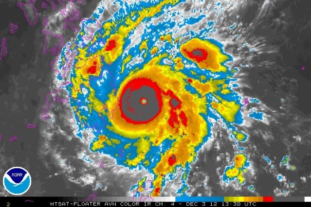
SUPER TYPHOON (STY) 26W (BOPHA) LOCATED APPROXIMATELY 630 NM
SOUTHEAST OF MANILA, PHILIPPINES HAS TRACKED WEST-NORTHWESTWARD AT
16 KNOTS OVER THE PAST SIX HOURS. ANIMATED ENHANCED INFRARED
SATELLITE IMAGERY SHOWS A WELL DEVELOPED, INTENSE SYSTEM THAT HAS A
9NM EYE AND HAS RAPIDLY INTENSIFIED IN THE PAST TWELVE HOURS. THE
CURRENT INTENSITY OF 140 KNOTS IS BASED ON CONGRUENT DVORAK
ESTIMATES FROM PGTW, RJTD, AND KNES, ALL OF WHICH SUPPORT THE RECENT
RAPID INTENSIFICATION AND IS ADDITIONALLY SUPPORTED BY A RECENT JUMP
IN THE LATEST CIMMS SATCON ESTIMATE OF 141 KNOTS. UPPER LEVEL
ANALYSIS INDICATES THE POINT-SOURCE ANTICYCLONE REMAINS WELL
ESTABLISHED AND CONTINUES TO PROVIDE AMPLE RADIAL OUTFLOW AND LOW
(05 TO 10 KNOTS) VERTICAL WIND SHEAR (VWS) OVER THE SYSTEM. STY 26W
CONTINUES TO TRACK WEST-NORTHWESTWARD ALONG THE SOUTHERN EXTENT OF
THE DEEP- LAYERED SUBTROPICAL RIDGE (STR) LOCATED TO THE NORTHEAST.
3. FORECAST REASONING.
A. NO CHANGE TO THE FORECAST PHILOSOPHY SINCE THE PREVIOUS
PROGNOSTIC REASONING MESSAGE BUT FORECASTED INTENSITIES HAVE
INCREASED BASED ON THE RECENT RAPID INTENSIFICATION.
B. STY 26W IS FORECAST TO CONTINUE TRACKING WEST-NORTHWESTWARD
ALONG THE SOUTHERN PERIPHERY OF THE STR, MAKING LANDFALL INTO THE
PHILIPPINES JUST PRIOR TO TAU 12. AFTER LANDFALL, STY 26W WILL BEGIN
TO SLOW AS IT TRACKS ALONG THE SOUTHWESTERN QUADRANT OF THE CURRENT
STEERING RIDGE. INTENSITIES WILL DECREASE FOR THE NEXT 36 HOURS AS
STY 26W TRACKS ACROSS LAND AND LOSES SOME ORGANIZATION THROUGH
CENTRAL MINDANAO. AFTER TAU 36, STY 26W WILL SLIGHTLY REINTENSIFY AS
IT REORGANIZES AND TRACKS ACROSS THE WARM (28-30 DEGREES CELSIUS)
SULU SEA AND INTO THE SOUTH CHINA SEA (SCS), GAINING A STRONGER
POLEWARD OUTFLOW FROM THE WESTERLIES, AND MAINTAINING AS A STRONG
TYPHOON. OTHER THAN JGSM TRACKING THE SYSTEM SLIGHTLY TO THE NORTH,
DYNAMIC MODEL GUIDANCE REMAINS IN VERY TIGHT AGREEMENT. DUE TO THIS
TIGHT AGREEMENT, FORECAST CONFIDENCE REMAINS HIGH IN THIS PORTION OF
THE FORECAST TRACK.
C. IN THE EXTENDED TAUS, STY 26W IS EXPECTED TO MOVE INTO THE
SCS, SLOWING TO AN ALMOST QUASI-STATIONARY SPEED, AS THE SYSTEM
ENTERS A WEAK STEERING ENVIRONMENT IN A COL REGION BETWEEN TWO
ELONGATED LOBES OF THE STR. INCREASING VWS AND INTERACTION WITH THE
NORTHEAST MONSOON WILL OFFSET THE ENHANCED POLEWARD OUTFLOW,
WEAKENING THE SYSTEM TO 95 KNOTS BY TAU 120. MODEL GUIDANCE
CONTINUES TO DIVERGE IN THE EXTENDED TAUS, WHICH IS INDICATIVE OF A
WEAK STEERING ENVIRONMENT. DUE TO THIS FORECASTED WEAK STEERING
ENVIRONMENT, THE CONFIDENCE IN THE FORECAST TRACK IN THE EXTENDED
TAUS REMAINS LOW.//
NNNN
0 likes   
Remember, all of my post aren't official. For official warnings and discussions, Please refer to your local NWS products...

NWS for the Western Pacific

https://www.weather.gov/gum/

User avatar
euro6208
Category 5
Category 5
Posts: 18547
Joined: Mon Mar 08, 2004 7:50 pm
Location: Guam

Re: WPAC: BOPHA - Typhoon

#560 Postby euro6208 » Mon Dec 03, 2012 11:28 am

supercane4867 wrote:
euro6208 wrote:this is likely a sub 900 mb (875 to be exact) typhoon headed straight for land...winds??? i say 185 to 200 mph sustained...unbelievable! if only we had recon to confirm this...


I agree there may be 180mph winds, but Bopha is too small for a sub-900mb pressure, 910-20mb is more likely


you must be new to tracking tropical cyclones...small typhoons can have sub 900 mb pressure too and there are many...i can think of Super Typhoon Rita in 1978 is similiar in size to bopha and she bottomed out at 880 mb...
0 likes   
Remember, all of my post aren't official. For official warnings and discussions, Please refer to your local NWS products...

NWS for the Western Pacific

https://www.weather.gov/gum/


Return to “2012”

Who is online

Users browsing this forum: No registered users and 42 guests