ATL: BERYL - Post-Tropical

Moderator: S2k Moderators

Message
Author
User avatar
lester
S2K Supporter
S2K Supporter
Posts: 1305
Age: 36
Joined: Sat Aug 27, 2005 5:21 pm
Location: Washington, DC
Contact:

Re: ATL: BERYL - Recon Discussion

#701 Postby lester » Sat May 26, 2012 4:03 pm

hurricanefloyd5 wrote:
cycloneye wrote:A few 40kts and 50kts on last set and 999.1 mbs,the lowest pressure.


Dose this mean winds at 50kts(60mph) in beryl. If yes then chances of this being a hurricane is what if at 50kts (60mph) winds?


Those winds are at flight level, not at the surface. At the surface probably 45-50 mph winds.
0 likes   

User avatar
NC George
Category 2
Category 2
Posts: 633
Age: 55
Joined: Sun Sep 14, 2003 11:44 am
Location: Washington, NC, USA

Re: ATL: BERYL - Subtropical Storm

#702 Postby NC George » Sat May 26, 2012 4:05 pm

sponger wrote:We are rooting on as much as a transition as possible to tropical as we need the rain!

Surf this morning was great but we desparetely need rain!


Well I hope you get it and not us. I'm already sitting under a rainband, and we actually don't need the rain, already got plenty this week.
0 likes   
Bertha '96, Fran '96, Bonnie '98, Dennis '99, Floyd '99 :eek: , Isabel '03, Irene '11, Matthew '16, Isaias '20, PTC16????

Avatar is heading into Florence 2018, moving friend's boat, only land between us and Hurricane Florence is Ocracoke Island!

User avatar
cycloneye
Admin
Admin
Posts: 143923
Age: 68
Joined: Thu Oct 10, 2002 10:54 am
Location: San Juan, Puerto Rico

Re: ATL: BERYL - Recon Discussion

#703 Postby cycloneye » Sat May 26, 2012 4:11 pm

A bunch of data is rain contaminated,but one of the few that is good is this one:

From 121° at 54 knots
(From the ESE at ~ 62.1 mph)
0 likes   
Visit the Caribbean-Central America Weather Thread where you can find at first post web cams,radars
and observations from Caribbean basin members Click Here

User avatar
cycloneye
Admin
Admin
Posts: 143923
Age: 68
Joined: Thu Oct 10, 2002 10:54 am
Location: San Juan, Puerto Rico

Re: ATL: BERYL - Recon

#704 Postby cycloneye » Sat May 26, 2012 4:13 pm

000
URNT15 KNHC 262109
AF307 0102A BERYL HDOB 19 20120526
210100 3207N 07537W 9626 00438 0122 +204 //// 123043 043 024 004 01
210130 3209N 07535W 9635 00430 0123 +206 +204 123043 043 028 001 00
210200 3210N 07534W 9629 00435 0124 +205 //// 124043 043 025 001 01
210230 3212N 07532W 9628 00437 0125 +205 +203 126042 042 023 001 00
210300 3213N 07530W 9627 00440 0126 +209 +198 127041 041 021 002 00
210330 3214N 07528W 9630 00439 0128 +210 +196 129040 040 023 001 00
210400 3216N 07527W 9629 00442 0129 +210 +197 129039 039 023 003 00
210430 3217N 07525W 9629 00441 0131 +209 +195 130039 039 025 001 00
210500 3219N 07523W 9631 00440 0133 +205 +200 128038 039 027 001 00
210530 3220N 07521W 9627 00445 0131 +203 //// 127037 037 027 002 01
210600 3222N 07519W 9631 00444 0132 +202 //// 127037 038 026 001 01
210630 3223N 07517W 9628 00439 0127 +206 +196 129037 037 026 000 00
210700 3224N 07516W 9631 00438 0130 +205 +196 128036 036 025 001 00
210730 3226N 07514W 9627 00442 0130 +203 +198 129035 036 024 000 00
210800 3227N 07512W 9629 00442 0131 +204 +196 131035 035 023 002 00
210830 3229N 07510W 9627 00444 0132 +205 +194 133035 035 021 001 00
210900 3230N 07508W 9629 00442 0131 +214 +179 135036 036 021 001 00
210930 3232N 07507W 9627 00446 0132 +212 +181 135036 037 021 001 00
211000 3233N 07505W 9630 00443 0132 +217 +174 136035 035 015 003 00
211030 3234N 07503W 9627 00446 0133 +216 +172 137035 035 019 000 00
0 likes   
Visit the Caribbean-Central America Weather Thread where you can find at first post web cams,radars
and observations from Caribbean basin members Click Here

User avatar
cycloneye
Admin
Admin
Posts: 143923
Age: 68
Joined: Thu Oct 10, 2002 10:54 am
Location: San Juan, Puerto Rico

Re: ATL: BERYL - Recon

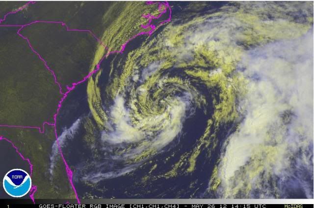
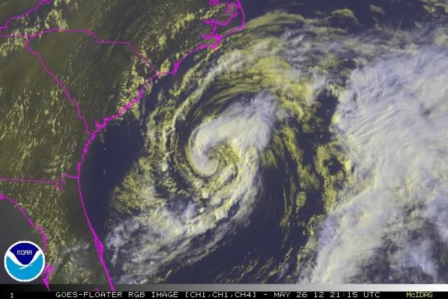
#705 Postby cycloneye » Sat May 26, 2012 4:15 pm

Product: Air Force Vortex Message (URNT12 KNHC)
Transmitted: 26th day of the month at 21:04Z
Aircraft: Air Force Aircraft (Last 3 digits of the tail number are 307)
Storm Number & Year: 02L in 2012
Storm Name: Beryl (flight in the North Atlantic basin)
Mission Number: 1
Observation Number: 06
A. Time of Center Fix: 26th day of the month at 20:41:40Z
B. Center Fix Coordinates: 31°20'N 76°31'W (31.3333N 76.5167W) (View map)
B. Center Fix Location: 214 miles (344 km) to the SE (140°) from Myrtle Beach, SC, USA.
C. Minimum Height at Standard Level: Not Available
D. Estimated (by SFMR or visually) Maximum Surface Wind: 35kts (~ 40.3mph)
E. Location of the Estimated Maximum Surface Wind: 17 nautical miles (20 statute miles) to the SW (224°) of center fix
F. Maximum Flight Level Wind Inbound: From 322° at 37kts (From the NW at ~ 42.6mph)
G. Location of Maximum Flight Level Wind Inbound: 20 nautical miles (23 statute miles) to the SW (223°) of center fix
H. Minimum Sea Level Pressure: 999mb (29.50 inHg) - Extrapolated
I. Maximum Flight Level Temp & Pressure Altitude Outside Eye: 21°C (70°F) at a pressure alt. of 428m (1,404ft)
J. Maximum Flight Level Temp & Pressure Altitude Inside Eye: 23°C (73°F) at a pressure alt. of 268m (879ft)
K. Dewpoint Temp (collected at same location as temp inside eye): 22°C (72°F)
K. Sea Surface Temp (collected at same location as temp inside eye): Not Available
L. Eye Character: Not Available
M. Eye Shape: Not Available
N. Fix Determined By: Penetration, Radar, Wind, Pressure and Temperature
N. Fix Levels (sfc and flt lvl centers are within 5nm of each other): Surface and 1,500 feet
O. Navigation Fix Accuracy: 0.02 nautical miles
O. Meteorological Accuracy: 2 nautical miles
Remarks Section:
Maximum Wind Outbound: 55kts (~ 63.3mph) in the northeast quadrant at 20:55:30Z
Maximum Flight Level Wind: 55kts (~ 63.3mph) in the northeast quadrant at 20:55:30Z

Sea Level Pressure Extrapolation From: Below 1,500 feet
0 likes   
Visit the Caribbean-Central America Weather Thread where you can find at first post web cams,radars
and observations from Caribbean basin members Click Here

User avatar
weatherSnoop
S2K Supporter
S2K Supporter
Posts: 702
Age: 62
Joined: Wed Oct 09, 2002 10:06 pm
Location: Tampa, FL
Contact:

Re: ATL: BERYL - Recon Discussion

#706 Postby weatherSnoop » Sat May 26, 2012 4:18 pm

cycloneye wrote:If anyone takes over I will do the second pass.


I can take over HDOB's for awhile
0 likes   

User avatar
cycloneye
Admin
Admin
Posts: 143923
Age: 68
Joined: Thu Oct 10, 2002 10:54 am
Location: San Juan, Puerto Rico

Re: ATL: BERYL - Recon Discussion

#707 Postby cycloneye » Sat May 26, 2012 4:21 pm

Ok take over.
0 likes   
Visit the Caribbean-Central America Weather Thread where you can find at first post web cams,radars
and observations from Caribbean basin members Click Here

User avatar
cycloneye
Admin
Admin
Posts: 143923
Age: 68
Joined: Thu Oct 10, 2002 10:54 am
Location: San Juan, Puerto Rico

Re: ATL: BERYL - Subtropical Storm

#708 Postby cycloneye » Sat May 26, 2012 4:23 pm

Dvorak image.

Image
0 likes   
Visit the Caribbean-Central America Weather Thread where you can find at first post web cams,radars
and observations from Caribbean basin members Click Here

User avatar
TropicalAnalystwx13
Category 5
Category 5
Posts: 2109
Age: 27
Joined: Tue Jul 19, 2011 8:20 pm
Location: Wilmington, NC
Contact:

#709 Postby TropicalAnalystwx13 » Sat May 26, 2012 4:29 pm


The following post is NOT an official forecast and should not be used as such. It is just the opinion of the poster and may or may not be backed by sound meteorological data. It is NOT endorsed by any professional institution including storm2k.org. For Official Information please refer to the NHC and NWS products.


Beryl has some mighty strong flight level winds (Up to 60 mph) and recon has found some 50 mph surface winds. Convection is wrapping fully around the center as the system mixes dry air out, and SSTs continue to increase as Beryl moves SW.

I could see a 65-70 mph peak. Definitely not 50 mph. Not in my opinion anyways.

cycloneye adds S2K Disclaimer
0 likes   

User avatar
ronjon
Category 5
Category 5
Posts: 4811
Joined: Fri Aug 19, 2005 5:17 pm
Location: Hernando Beach, FL

Re: ATL: BERYL - Subtropical Storm

#710 Postby ronjon » Sat May 26, 2012 4:30 pm

Starting to take on that classic tropical cyclone shape - transition may be underway to tropical. Convective trends tonight will be fun to watch. Beryl is approaching the warmer SSTs now. Pressures dropped 2 mb today.
0 likes   

User avatar
weatherSnoop
S2K Supporter
S2K Supporter
Posts: 702
Age: 62
Joined: Wed Oct 09, 2002 10:06 pm
Location: Tampa, FL
Contact:

#711 Postby weatherSnoop » Sat May 26, 2012 4:30 pm

URNT15 KNHC 262119
AF307 0102A BERYL HDOB 20 20120526
211100 3236N 07501W 9630 00445 0133 +215 +174 137034 035 018 000 03
211130 3238N 07500W 9626 00448 0133 +215 +175 131036 036 /// /// 03
211200 3240N 07502W 9628 00445 0133 +215 +175 121035 036 /// /// 03
211230 3240N 07505W 9628 00447 0134 +215 +179 116031 032 011 001 03
211300 3239N 07507W 9626 00448 0139 +215 +178 117033 034 016 000 03
211330 3239N 07510W 9694 00395 0143 +220 +179 116035 035 017 001 00
211400 3238N 07513W 9702 00387 0143 +220 +182 115036 036 020 000 00
211430 3238N 07516W 9698 00390 0143 +220 +181 115036 036 019 001 00
211500 3238N 07518W 9700 00388 0142 +220 +180 115035 035 020 000 00
211530 3238N 07521W 9699 00388 0142 +218 +181 114036 036 021 001 00
211600 3238N 07524W 9700 00388 0142 +209 +198 109034 035 015 003 00
211630 3238N 07527W 9698 00389 0143 +204 //// 105033 034 017 002 01
211700 3238N 07530W 9700 00387 0142 +207 +203 105035 036 020 001 00
211730 3238N 07533W 9699 00388 0141 +212 +195 107035 036 021 001 00
211800 3238N 07536W 9700 00387 0141 +210 +196 106036 036 023 000 00
211830 3238N 07539W 9699 00387 0140 +212 +195 105036 036 025 001 00
211900 3238N 07541W 9703 00383 0139 +216 +190 105036 036 025 001 00
211930 3237N 07544W 9698 00386 0137 +217 +188 104037 037 027 001 00
212000 3237N 07547W 9698 00384 0136 +215 +193 103038 038 028 003 00
212030 3237N 07550W 9698 00384 0135 +215 +191 103038 039 028 002 00
0 likes   

User avatar
weatherSnoop
S2K Supporter
S2K Supporter
Posts: 702
Age: 62
Joined: Wed Oct 09, 2002 10:06 pm
Location: Tampa, FL
Contact:

#712 Postby weatherSnoop » Sat May 26, 2012 4:36 pm

URNT15 KNHC 262129
AF307 0102A BERYL HDOB 21 20120526
212100 3237N 07553W 9698 00384 0135 +215 +195 101038 039 026 001 00
212130 3237N 07556W 9700 00381 0135 +214 +196 097039 039 025 002 00
212200 3237N 07559W 9701 00381 0135 +214 +196 097039 040 027 002 00
212230 3237N 07602W 9703 00381 0136 +214 +197 096039 039 026 001 00
212300 3237N 07605W 9698 00385 0136 +215 +195 094039 039 027 001 00
212330 3237N 07608W 9698 00385 0136 +215 +195 091039 040 029 002 00
212400 3237N 07611W 9702 00380 0135 +213 +198 088039 040 028 001 00
212430 3236N 07613W 9698 00382 0135 +210 +207 083039 040 028 001 00
212500 3236N 07616W 9700 00384 0135 +210 +207 082038 039 028 002 00
212530 3236N 07619W 9700 00383 0135 +210 +207 081038 038 027 001 00
212600 3236N 07622W 9701 00381 0135 +210 //// 079037 037 028 002 01
212630 3236N 07625W 9700 00381 0134 +208 //// 076037 037 026 003 01
212700 3236N 07628W 9703 00377 0135 +208 //// 074037 039 028 000 01
212730 3236N 07631W 9703 00383 0135 +208 //// 072039 040 026 003 01
212800 3236N 07634W 9701 00384 0136 +209 +207 069039 041 029 002 00
212830 3236N 07637W 9699 00384 0137 +208 //// 066040 041 028 001 01
212900 3236N 07640W 9699 00384 0136 +211 +203 065041 042 029 001 00
212930 3235N 07643W 9700 00382 0137 +208 +206 060041 042 028 002 00
213000 3235N 07646W 9702 00382 0136 +210 +202 062040 041 029 002 00
213030 3235N 07648W 9698 00383 0136 +209 +202 060040 041 028 000 00
$$
0 likes   

tolakram
Admin
Admin
Posts: 19990
Age: 61
Joined: Sun Aug 27, 2006 8:23 pm
Location: Florence, KY (name is Mark)

Re: ATL: BERYL - Recon

#713 Postby tolakram » Sat May 26, 2012 4:37 pm

Un-decoded VDM :) Easier to read in my opinion.

000
URNT12 KNHC 262104
VORTEX DATA MESSAGE AL022012
A. 26/20:41:40Z
B. 31 deg 20 min N
076 deg 31 min W
C. NA
D. 35 kt
E. 224 deg 17 nm
F. 322 deg 37 kt
G. 223 deg 20 nm
H. EXTRAP 999 mb
I. 21 C / 428 m
J. 23 C / 268 m
K. 22 C / NA
L. NA
M. NA
N. 12345 / 01
O. 0.02 / 2 nm
P. AF307 0102A BERYL OB 06
MAX OUTBOUND AND MAX FL WIND 55 KT NE QUAD 20:55:30Z
SLP EXTRAP FROM BELOW 1500 FT
;
0 likes   
M a r k
- - - - -
Join us in chat: Storm2K Chatroom Invite. Android and IOS apps also available.

The posts in this forum are NOT official forecasts and should not be used as such. Posts are NOT endorsed by any professional institution or STORM2K.org. For official information and forecasts, please refer to NHC and NWS products.

Aric Dunn
Category 5
Category 5
Posts: 21238
Age: 42
Joined: Sun Sep 19, 2004 9:58 pm
Location: Ready for the Chase.
Contact:

#714 Postby Aric Dunn » Sat May 26, 2012 4:40 pm

much easier to read.
0 likes   
Note: If I make a post that is brief. Please refer back to previous posts for the analysis or reasoning. I do not re-write/qoute what my initial post said each time.
If there is nothing before... then just ask :)

Space & Atmospheric Physicist, Embry-Riddle Aeronautical University,
I believe the sky is falling...

User avatar
hurricanefloyd5
Category 5
Category 5
Posts: 1659
Age: 44
Joined: Sun May 02, 2004 10:53 am
Location: Spartanburg
Contact:

ATL: BERYL - Recon Discussion

#715 Postby hurricanefloyd5 » Sat May 26, 2012 4:42 pm

If recon confirm increased to 60-65mph dose that mean it will stay farther north or farther south?
0 likes   

tolakram
Admin
Admin
Posts: 19990
Age: 61
Joined: Sun Aug 27, 2006 8:23 pm
Location: Florence, KY (name is Mark)

Re: ATL: BERYL - Subtropical Storm

#716 Postby tolakram » Sat May 26, 2012 4:43 pm

Latest, enhanced contrast

Image

Live visible loop: http://wwwghcc.msfc.nasa.gov/cgi-bin/ge ... umframes=5
0 likes   
M a r k
- - - - -
Join us in chat: Storm2K Chatroom Invite. Android and IOS apps also available.

The posts in this forum are NOT official forecasts and should not be used as such. Posts are NOT endorsed by any professional institution or STORM2K.org. For official information and forecasts, please refer to NHC and NWS products.

User avatar
weatherSnoop
S2K Supporter
S2K Supporter
Posts: 702
Age: 62
Joined: Wed Oct 09, 2002 10:06 pm
Location: Tampa, FL
Contact:

#717 Postby weatherSnoop » Sat May 26, 2012 4:46 pm

URNT15 KNHC 262139
AF307 0102A BERYL HDOB 22 20120526
213100 3235N 07651W 9700 00382 0136 +210 +200 060041 041 029 001 00
213130 3235N 07654W 9699 00384 0136 +210 +200 060041 042 030 001 00
213200 3235N 07657W 9700 00382 0136 +210 +197 061042 043 029 002 00
213230 3235N 07700W 9700 00382 0135 +210 +198 062043 043 028 002 00
213300 3235N 07703W 9698 00383 0136 +207 +204 059042 042 030 000 00
213330 3234N 07706W 9701 00382 0137 +206 +205 057042 043 028 002 00
213400 3234N 07709W 9701 00384 0137 +208 +203 057041 041 029 001 00
213430 3234N 07712W 9701 00383 0138 +205 //// 055042 042 029 001 01
213500 3234N 07714W 9700 00383 0137 +206 //// 055042 043 030 000 01
213530 3234N 07717W 9697 00388 0138 +210 +200 055041 043 031 001 00
213600 3234N 07720W 9702 00382 0137 +210 +201 053041 042 032 000 00
213630 3234N 07723W 9703 00382 0138 +209 +204 053042 043 032 002 00
213700 3234N 07726W 9700 00387 0138 +213 +196 053041 042 033 001 00
213730 3233N 07729W 9699 00382 0136 +212 +197 053040 041 033 001 00
213800 3233N 07731W 9701 00382 0137 +210 +200 054039 040 031 003 00
213830 3233N 07734W 9698 00387 0139 +210 +203 056039 039 029 002 00
213900 3233N 07737W 9700 00385 0140 +210 +202 053038 039 029 002 00
213930 3233N 07739W 9699 00386 0140 +211 +196 052038 039 031 002 00
214000 3233N 07742W 9698 00387 0140 +212 +200 052039 040 032 001 00
214030 3233N 07745W 9701 00386 0140 +211 +202 052039 040 031 002 00
$$
;
0 likes   

Aric Dunn
Category 5
Category 5
Posts: 21238
Age: 42
Joined: Sun Sep 19, 2004 9:58 pm
Location: Ready for the Chase.
Contact:

#718 Postby Aric Dunn » Sat May 26, 2012 4:49 pm

Water vapor tells the story. its still being influenced by the upper low. but that it seems is slowly weakening. only a matter of time... the moisture envelope seems to be improving. if it can shake off the upper low it may end up intensifying tomorrow.
http://www.ssd.noaa.gov/goes/east/eaus/loop-wv.html
0 likes   
Note: If I make a post that is brief. Please refer back to previous posts for the analysis or reasoning. I do not re-write/qoute what my initial post said each time.
If there is nothing before... then just ask :)

Space & Atmospheric Physicist, Embry-Riddle Aeronautical University,
I believe the sky is falling...

User avatar
cycloneye
Admin
Admin
Posts: 143923
Age: 68
Joined: Thu Oct 10, 2002 10:54 am
Location: San Juan, Puerto Rico

Re: ATL: BERYL - Recon Discussion

#719 Postby cycloneye » Sat May 26, 2012 4:53 pm

hurricanefloyd5 wrote:If recon confirm increased to 60-65mph dose that mean it will stay farther north or farther south?


I moved the post from recon discussion thread to here as for sure you will get the answer to your question much more rapidly over here.
0 likes   
Visit the Caribbean-Central America Weather Thread where you can find at first post web cams,radars
and observations from Caribbean basin members Click Here

ozonepete
Professional-Met
Professional-Met
Posts: 4743
Joined: Mon Sep 07, 2009 3:23 pm
Location: From Ozone Park, NYC / Now in Brooklyn, NY

Re: ATL: BERYL - Subtropical Storm

#720 Postby ozonepete » Sat May 26, 2012 4:55 pm

Circulation is separating from the jet flow to the east and compacting nicely. Looks good for another step up in intensification overnight. Here's RGB satellites from 10:15 AM EDT this morning and a little while ago at 5:15 PM.

Image

Image
0 likes   


Return to “2012”

Who is online

Users browsing this forum: No registered users and 52 guests