EPAC: CARLOTTA - Post-Tropical
Moderator: S2k Moderators

-
Rgv20

- S2K Supporter

- Posts: 2466
- Age: 39
- Joined: Wed Jan 05, 2011 5:42 pm
- Location: Edinburg/McAllen Tx
11PM EDT Forecast Track.
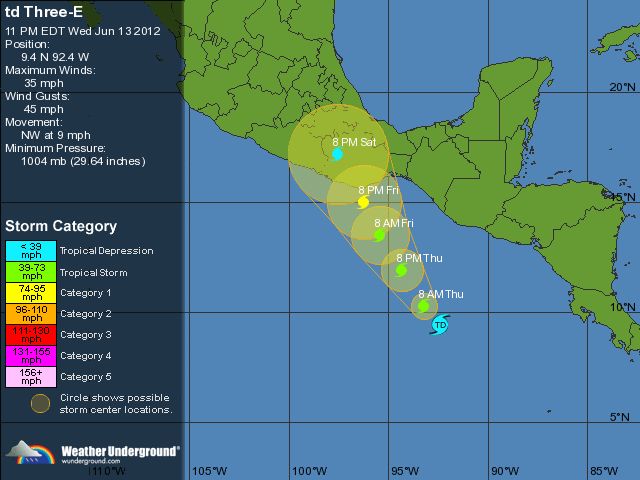
Statement as of 8:00 PM PDT on June 13, 2012
shower and thunderstorm activity associated with the area of
disturbed weather located several hundred miles south-southwest of
Guatemala has acquired enough organization for the system to be
classified as a tropical depression. Dvorak intensity estimates
from both SAB and TAFB support an initial intensity of 30 kt.
Since the system is still in its formative stage...the initial
motion estimate is a somewhat uncertain 305/8 kt. The cyclone is
situated on the southwestern periphery of a mid- to upper-level
ridge that extends into the northwestern Caribbean Sea and eastern
Gulf of Mexico. The depression is forecast to move northwestward
around the western side of the ridge during the next couple of
days. The track guidance is in relatively good agreement...and all
of the models show the cyclone approaching the southern coast of
Mexico in about 48-60 hours. The official forecast follows this
scenario and lies near the middle of the guidane envelope...
between the typically reliable GFS and ECMWF models.
The cyclone is expected to remain in a low-shear environment and
over warm waters during the next 48 hours. Most of the intensity
guidance calls for steady strengthening...with the HWRF being the
most aggressive. Even the global models show significant deepening
of the system during the next day or two. As a result...the NHC
forecast calls for steady strengthening and brings the cyclone to
hurricane strength in a couple of days. Since the circulation is
relatively small and the shear is expected to remain light...rapid
intensification is a realistic possibility during the next 48
hours. Therefore...the NHC forecast is higher than the intensity
consensus...leaning toward the SHIPS and HWRF solutions.
The track and intensity forecast has required the issuance of a
Hurricane Watch for a portion of the southern coast of Mexico.
Users are reminded not to focus on the exact forecast track as
typical NHC forecast errors at 48 and 72 hours are 80-110 N mi.
Forecast positions and Max winds
init 14/0300z 9.4n 92.4w 30 kt 35 mph
12h 14/1200z 10.3n 93.2w 35 kt 40 mph
24h 15/0000z 11.9n 94.3w 45 kt 50 mph
36h 15/1200z 13.5n 95.4w 55 kt 65 mph
48h 16/0000z 15.0n 96.2w 65 kt 75 mph
72h 17/0000z 17.2n 97.5w 30 kt 35 mph...inland
96h 18/0000z...dissipated
$$
forecaster Brown/Berg
Last edited by Rgv20 on Wed Jun 13, 2012 10:02 pm, edited 1 time in total.
0 likes
The following post is NOT an official forecast and should not be used as such. It is just the opinion of the poster and may or may not be backed by sound meteorological data. It is NOT endorsed by any professional institution including storm2k.org For Official Information please refer to the NHC and NWS products.
-
cycloneye

- Admin

- Posts: 149493
- Age: 69
- Joined: Thu Oct 10, 2002 10:54 am
- Location: San Juan, Puerto Rico
Re: EPAC: THREE-E - Tropical Depression
It looks like the recon mission on Friday afternoon will be on time as landfall will be at night.
0 likes
Visit the Caribbean-Central America Weather Thread where you can find at first post web cams,radars
and observations from Caribbean basin members Click Here
and observations from Caribbean basin members Click Here
-
cycloneye
- Admin
- Posts: 149493
- Age: 69
- Joined: Thu Oct 10, 2002 10:54 am
- Location: San Juan, Puerto Rico
Re: EPAC: THREE-E - Tropical Depression
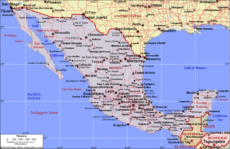
Does anyone has a graphic with the cities that are in that area of landfall?
0 likes
Visit the Caribbean-Central America Weather Thread where you can find at first post web cams,radars
and observations from Caribbean basin members Click Here
and observations from Caribbean basin members Click Here
-
Yellow Evan

- Professional-Met

- Posts: 16240
- Age: 27
- Joined: Fri Jul 15, 2011 12:48 pm
- Location: Henderson, Nevada/Honolulu, HI
- Contact:
-
Aric Dunn
- Category 5

- Posts: 21238
- Age: 43
- Joined: Sun Sep 19, 2004 9:58 pm
- Location: Ready for the Chase.
- Contact:
Re: EPAC: THREE-E - Tropical Depression
cycloneye wrote:Does anyone has a graphic with the cities that are in that area of landfall?
you mean this ?

and yes .. RI is very likely... two outflow channels look to be setting up. the northern half more prominent though. I'm looking at hurricane tomorrow afternoon. especially with the recent convective burst right over the center a sign its deepening.
0 likes
Note: If I make a post that is brief. Please refer back to previous posts for the analysis or reasoning. I do not re-write/qoute what my initial post said each time.
If there is nothing before... then just ask
Space & Atmospheric Physicist, Embry-Riddle Aeronautical University,
I believe the sky is falling...
If there is nothing before... then just ask
Space & Atmospheric Physicist, Embry-Riddle Aeronautical University,
I believe the sky is falling...
-
Rgv20
- S2K Supporter
- Posts: 2466
- Age: 39
- Joined: Wed Jan 05, 2011 5:42 pm
- Location: Edinburg/McAllen Tx
Re: EPAC: THREE-E - Tropical Depression
cycloneye wrote:Does anyone has a graphic with the cities that are in that area of landfall?
This is the most detailed map I could find.....It looks like its going to affect from Salina Cruz to Acapulco.
http://i61.photobucket.com/albums/h62/c ... ms/302.gif
Thank you for posting it. Acapulco is a very populated city but for now is not on the bulls eye of the forecast track.
0 likes
The following post is NOT an official forecast and should not be used as such. It is just the opinion of the poster and may or may not be backed by sound meteorological data. It is NOT endorsed by any professional institution including storm2k.org For Official Information please refer to the NHC and NWS products.
-
cycloneye
- Admin
- Posts: 149493
- Age: 69
- Joined: Thu Oct 10, 2002 10:54 am
- Location: San Juan, Puerto Rico
Re: EPAC: THREE-E - Tropical Depression
Aric Dunn wrote:cycloneye wrote:Does anyone has a graphic with the cities that are in that area of landfall?
you mean this ?
http://www.nhc.noaa.gov/storm_graphics/ ... _NL_sm.gif
and yes .. RI is very likely... two outflow channels look to be setting up. the northern half more prominent though. I'm looking at hurricane tomorrow afternoon.
No,is a graphic that has the cities (Acapulco,Punta Maldonado,Puerto Angel etc)
Edit=Was posted above.
0 likes
Visit the Caribbean-Central America Weather Thread where you can find at first post web cams,radars
and observations from Caribbean basin members Click Here
and observations from Caribbean basin members Click Here
-
bamajammer4eva
- Category 4

- Posts: 907
- Joined: Sun Apr 18, 2010 3:21 am
- Location: Ozark, AL
Re: EPAC: THREE-E - Tropical Depression
Accuweather says it will be gulfbound after crossing Mexico.
http://www.accuweather.com/en/weather-n ... once/66458
Pacific Tropical Trouble Could Jump Ship to Atlantic
AccuWeather.com Expert Senior Meteorologist Dan Kottlowski said that the disturbance will track northward toward the Gulf of Tehuantepac in southern Mexico Friday or Saturday.
The disturbance will emerge into the Bay of Campeche, spanning into the northwestern Caribbean, by this weekend or early next week.
"This large area of low pressure spanning the southwest Gulf of Mexico to the northwest Caribbean will need to be monitored next week for tropical development," Kottlowski said.
http://www.accuweather.com/en/weather-n ... once/66458
0 likes
-
Yellow Evan
- Professional-Met
- Posts: 16240
- Age: 27
- Joined: Fri Jul 15, 2011 12:48 pm
- Location: Henderson, Nevada/Honolulu, HI
- Contact:
-
cycloneye
- Admin
- Posts: 149493
- Age: 69
- Joined: Thu Oct 10, 2002 10:54 am
- Location: San Juan, Puerto Rico
Re: EPAC: THREE-E - Tropical Depression
Rgv20 wrote:cycloneye wrote:Does anyone has a graphic with the cities that are in that area of landfall?
This is the most detailed map I could find.....It looks like its going to affect from Salina Cruz to Acapulco.
http://i61.photobucket.com/albums/h62/c ... ms/302.gif
Thank you for posting it. Acapulco is a very populated city but for now is not on the bulls eye of the forecast track.
0 likes
Visit the Caribbean-Central America Weather Thread where you can find at first post web cams,radars
and observations from Caribbean basin members Click Here
and observations from Caribbean basin members Click Here
-
Aric Dunn
- Category 5
- Posts: 21238
- Age: 43
- Joined: Sun Sep 19, 2004 9:58 pm
- Location: Ready for the Chase.
- Contact:
Re: EPAC: THREE-E - Tropical Depression
bamajammer4eva wrote:Accuweather says it will be gulfbound after crossing Mexico.Pacific Tropical Trouble Could Jump Ship to Atlantic
AccuWeather.com Expert Senior Meteorologist Dan Kottlowski said that the disturbance will track northward toward the Gulf of Tehuantepac in southern Mexico Friday or Saturday.
The disturbance will emerge into the Bay of Campeche, spanning into the northwestern Caribbean, by this weekend or early next week.
"This large area of low pressure spanning the southwest Gulf of Mexico to the northwest Caribbean will need to be monitored next week for tropical development," Kottlowski said.
http://www.accuweather.com/en/weather-n ... once/66458
looking at everything the last few days I have mentioned it a few times... the BOC is more likely than the rest (well that direction anyway it would have to survive). I typically always seem not in agreement with accuweather (reasons are well obvious) but its looking that way.
0 likes
Note: If I make a post that is brief. Please refer back to previous posts for the analysis or reasoning. I do not re-write/qoute what my initial post said each time.
If there is nothing before... then just ask
Space & Atmospheric Physicist, Embry-Riddle Aeronautical University,
I believe the sky is falling...
If there is nothing before... then just ask
Space & Atmospheric Physicist, Embry-Riddle Aeronautical University,
I believe the sky is falling...
-
Aric Dunn
- Category 5
- Posts: 21238
- Age: 43
- Joined: Sun Sep 19, 2004 9:58 pm
- Location: Ready for the Chase.
- Contact:
Re: EPAC: THREE-E - Tropical Depression
cycloneye wrote:Rgv20 wrote:cycloneye wrote:Does anyone has a graphic with the cities that are in that area of landfall?
This is the most detailed map I could find.....It looks like its going to affect from Salina Cruz to Acapulco.
http://i61.photobucket.com/albums/h62/c ... ms/302.gif
Thank you for posting it. Acapulco is a very populated city but for now is not on the bulls eye of the forecast track.
that whole area is actually pretty populated. not a major city but still millions of people... similar to east coast of florida north of west palm.
http://farm6.staticflickr.com/5176/5457 ... 0fbc_o.jpg
0 likes
Note: If I make a post that is brief. Please refer back to previous posts for the analysis or reasoning. I do not re-write/qoute what my initial post said each time.
If there is nothing before... then just ask
Space & Atmospheric Physicist, Embry-Riddle Aeronautical University,
I believe the sky is falling...
If there is nothing before... then just ask
Space & Atmospheric Physicist, Embry-Riddle Aeronautical University,
I believe the sky is falling...
-
Yellow Evan
- Professional-Met
- Posts: 16240
- Age: 27
- Joined: Fri Jul 15, 2011 12:48 pm
- Location: Henderson, Nevada/Honolulu, HI
- Contact:
Re: EPAC: THREE-E - Tropical Depression
Aric Dunn wrote:Rgv20 wrote:cycloneye wrote:
This is the most detailed map I could find.....It looks like its going to affect from Salina Cruz to Acapulco.
http://i61.photobucket.com/albums/h62/c ... ms/302.gif
Thank you for posting it. Acapulco is a very populated city but for now is not on the bulls eye of the forecast track.
that whole area is actually pretty populated. not a major city but still millions of people... similar to east coast of florida north of west palm.
http://farm6.staticflickr.com/5176/5457 ... 0fbc_o.jpg
The area where the storm is affecting is sparsely populated.
0 likes
-
Yellow Evan
- Professional-Met
- Posts: 16240
- Age: 27
- Joined: Fri Jul 15, 2011 12:48 pm
- Location: Henderson, Nevada/Honolulu, HI
- Contact:
Re: EPAC: THREE-E - Tropical Depression
Aric Dunn wrote:bamajammer4eva wrote:Accuweather says it will be gulfbound after crossing Mexico.Pacific Tropical Trouble Could Jump Ship to Atlantic
AccuWeather.com Expert Senior Meteorologist Dan Kottlowski said that the disturbance will track northward toward the Gulf of Tehuantepac in southern Mexico Friday or Saturday.
The disturbance will emerge into the Bay of Campeche, spanning into the northwestern Caribbean, by this weekend or early next week.
"This large area of low pressure spanning the southwest Gulf of Mexico to the northwest Caribbean will need to be monitored next week for tropical development," Kottlowski said.
http://www.accuweather.com/en/weather-n ... once/66458
looking at everything the last few days I have mentioned it a few times... the BOC is more likely than the rest (well that direction anyway it would have to survive). I typically always seem not in agreement with accuweather (reasons are well obvious) but its looking that way.
I don't think it will make it in the GOC.
0 likes

Re: EPAC: THREE-E - Tropical Depression
Is it a dry spot near the center or this thing has actually developed an eye like feature? I'm going to bed but it will be interesting to watch tomorrow.
0 likes

Carlotta is here
The NRL now shows Carlotta so here's to the 3rd TS of the Epac season! A few hours ago one of the AVN images looked exactly like another image I saved from an Epac TC of a quick forming TC around this same intensity. It went through RI. This could become very fascinating in terms of the evolution. This one so far has medium convection but the rotation is excellent and organization is amazing for a weak storm like this. Those spiral rainbands that are rapidly forming far out like that is cool...probably bringing heavy rain already onshore.
The NHC knows this could explode but I still think the forecast was a bit too low and they maybe should have said the confidence was low for the intensity part.
As for the models, the Euro once again was king by showing a hurricane 240 hours out around 12 days ago just like Bud. GFS was consistent for around 11 days as well. The latest hurricane models (the GFDL here) show some very weird stuff. The GFDL keeps taking future Carlotta right up to the coast and just abouts makes landfall and then dives it south and continues to strengthen it further!! 2 runs showed this and the 00z one shows it raking the coast of Mexico bring maximum punishment and then taking it offshore once more. What's it snorting?
Yep, this has a higher chance at explosive intensification than normal and the RI index reflects this. Pay no attention to the % probs. from the NHC product suite. The potential is huge with this one.
Glad to see you involved in the discussion Aric. I don't know much about outflow channels yet but is the max 4 representing each quadrant? This whole thing is reminding me of John from 2006. You nailed adv. being started at 11pm.
They do realize how rare it is for that to happen right? Its accuweather and I don't buy it.
??????
It appears to be a cloud-free region but I have a feeling the LLC is very close to it. We'll see if Carlotta jumps from TS to Hurricane in 6 hours at the 8 am advisory .
.
The NHC knows this could explode but I still think the forecast was a bit too low and they maybe should have said the confidence was low for the intensity part.
As for the models, the Euro once again was king by showing a hurricane 240 hours out around 12 days ago just like Bud. GFS was consistent for around 11 days as well. The latest hurricane models (the GFDL here) show some very weird stuff. The GFDL keeps taking future Carlotta right up to the coast and just abouts makes landfall and then dives it south and continues to strengthen it further!! 2 runs showed this and the 00z one shows it raking the coast of Mexico bring maximum punishment and then taking it offshore once more. What's it snorting?
CrazyC83 wrote:Could this RI all the way to major hurricane status?
Yep, this has a higher chance at explosive intensification than normal and the RI index reflects this. Pay no attention to the % probs. from the NHC product suite. The potential is huge with this one.
Aric Dunn wrote:and yes .. RI is very likely... two outflow channels look to be setting up. the northern half more prominent though. I'm looking at hurricane tomorrow afternoon. especially with the recent convective burst right over the center a sign its deepening.
Glad to see you involved in the discussion Aric. I don't know much about outflow channels yet but is the max 4 representing each quadrant? This whole thing is reminding me of John from 2006. You nailed adv. being started at 11pm.
Aric Dunn wrote:bamajammer4eva wrote:Accuweather says it will be gulfbound after crossing Mexico.Pacific Tropical Trouble Could Jump Ship to Atlantic
AccuWeather.com Expert Senior Meteorologist Dan Kottlowski said that the disturbance will track northward toward the Gulf of Tehuantepac in southern Mexico Friday or Saturday.
The disturbance will emerge into the Bay of Campeche, spanning into the northwestern Caribbean, by this weekend or early next week.
"This large area of low pressure spanning the southwest Gulf of Mexico to the northwest Caribbean will need to be monitored next week for tropical development," Kottlowski said.
http://www.accuweather.com/en/weather-n ... once/66458
looking at everything the last few days I have mentioned it a few times... the BOC is more likely than the rest (well that direction anyway it would have to survive). I typically always seem not in agreement with accuweather (reasons are well obvious) but its looking that way.
They do realize how rare it is for that to happen right? Its accuweather and I don't buy it.
Yellow Evan wrote:The area where the storm is affecting is sparsely populated.
??????
Macrocane wrote:Is it a dry spot near the center or this thing has actually developed an eye like feature? I'm going to bed but it will be interesting to watch tomorrow.
It appears to be a cloud-free region but I have a feeling the LLC is very close to it. We'll see if Carlotta jumps from TS to Hurricane in 6 hours at the 8 am advisory
0 likes
-
JonathanBelles
- Professional-Met
- Posts: 11430
- Age: 35
- Joined: Sat Dec 24, 2005 9:00 pm
- Location: School: Florida State University (Tallahassee, FL) Home: St. Petersburg, Florida
- Contact:
Carlotta just has a dry spot. No eye here: http://www.ssd.noaa.gov/PS/TROP/floater ... -long.html
0 likes
-
cycloneye
- Admin
- Posts: 149493
- Age: 69
- Joined: Thu Oct 10, 2002 10:54 am
- Location: San Juan, Puerto Rico
Re: EPAC: CARLOTTA - Tropical Storm
TROPICAL STORM CARLOTTA DISCUSSION NUMBER 2
NWS NATIONAL HURRICANE CENTER MIAMI FL EP032012
200 AM PDT THU JUN 14 2012
CONVECTIVE BANDING FEATURES ASSOCIATED WITH TROPICAL DEPRESSION
THREE-E HAVE INCREASED OVER THE PAST 6 HOURS...AND SATELLITE
INTENSITY ESTIMATES ARE A CONSENSUS T2.5/35 KT FROM TAFB...SAB...
AND UW-CIMSS ADT. IN ADDITION...A 14/0409Z ASCAT OVERPASS CAUGHT
THE WEST SIDE OF THE CIRCULATION AND REVEALED SEVERAL 34-KT
UNFLAGGED SURFACE WIND VECTORS. BASED ON THIS INFORMATION...THE
DEPRESSION HAS BEEN UPGRADED TO TROPICAL STORM CARLOTTA. THE
ESTIMATED CENTRAL PRESSURE IS BASED ON VALUABLE REPORTS FROM SHIP
V7DI7 LOCATED JUST EAST OF THE CENTER OF CARLOTTA.
THE INITIAL MOTION ESTIMATE IS 315/09 KT. CARLOTTA IS MOVING ON A
STEADY NORTHWESTWARD TRACK AND THIS GENERAL MOTION IS EXPECTED TO
CONTINUE FOR THE NEXT 48 HOURS OR SO AS THE CYCLONE MOVES AROUND
THE WESTERN PERIPHERY OF A MID- TO UPPER-LEVEL RIDGE SITUATED OVER
THE WESTERN CARIBBEAN SEA AND CENTRAL AMERICA. AFTER THAT...
HOWEVER...THE GLOBAL AND REGIONAL MODELS ARE NOW FORECASTING A
RIDGE TO DEVELOP TO THE NORTH OF THE CYCLONE FROM BAJA CALIFORNIA
EASTWARD ACROSS NORTHERN MEXICO AND INTO TEXAS. THIS BLOCKING
PATTERN IS EXPECTED TO FORCE CARLOTTA TO SLOW DOWN AND TURN
WESTWARD AS IT NEARS THE SOUTH-CENTRAL COAST OF MEXICO BY 72
HOURS...AND POSSIBLY STALL IN THE GENERAL VICINITY OF ACAPULCO BY
96 HOURS BEFORE DRIFTING BACK SOUTHWARD OVER THE OCEAN. THE MODEL
GUIDANCE HAS GENERALLY SHIFTED WESTWARD FROM THE PREVIOUS ADVISORY
AFTER 48 HOURS...AND THE OFFICIAL FORECAST TRACK REFLECTS THIS NEW
TREND AS WELL. AS A RESULT...96- AND 120-HOUR FORECAST POSITIONS
HAVE BEEN ADDED TO THIS ADVISORY. THE OFFICIAL FORECAST TRACK IS
ESSENTIALLY JUST AN UPDATE OF THE PREVIOUS ADVISORY THROUGH 48
HOURS...AND IS THEN WEST OF THE PREVIOUS TRACK AFTER THAT...AND
CLOSELY FOLLOWS A BLEND OF THE ECMWF...GFS...UKMET...NOGAPS...AND
HWRF MODELS.
ENVIRONMENTAL AND OCEANIC CONDITIONS ARE FAVORABLE FOR CARLOTTA TO
STRENGTHEN OVER THE NEXT 48 HOURS BEFORE THE CYCLONE BEGINS TO
INTERACT WITH LAND. AS ALLUDED TO IN THE PREVIOUS DISCUSSION...
RAPID INTENSIFICATION OF THE SMALL CYCLONE IS A VERY DISTINCT
POSSIBILITY IF THE LOW-LEVEL CENTER DEVELOPS FARTHER INTO THE
CONVECTIVE CLOUD MASS DURING THE NEXT 6 HOURS OR SO. ALTHOUGH THIS
SCENARIO WAS CONSIDERED FOR THIS ADVISORY...THE NEW INTENSITY
FORECAST IS ALREADY ABOUT 10 KT ABOVE THE PREVIOUS ADVISORY AND
MOST OF THE INTENSITY GUIDANCE AS WELL THROUGH 48 HOURS...WHICH IS
PLENTY ROBUST FOR ONLY A SECOND ADVISORY PACKAGE. HOWEVER...EVEN
THE HWRF AND ECMWF MODELS MAKE CARLOTTA A HURRICANE BY 48 HOURS...
WHICH ADDS SOME CREDENCE TO THE NEW HIGHER INTENSITY FORECAST. AT
72 HOURS AND BEYOND...THE INTENSITY FORECAST IS RATHER UNCERTAIN
DUE TO HOW MUCH CARLOTTA WILL INTERACT WITH THE COASTAL SIERRA
MADRE DEL SUR MOUNTAIN RANGE. IF CARLOTTA MOVES FARTHER INLAND THAN
EXPECTED...THEN THE CYCLONE WILL WEAKEN MORE THAN FORECAST...AND
VICE VERSA IF IT SHOULD INSTEAD REMAIN OFFSHORE.
BASED ON THE NEW TRACK AND INTENSITY FORECASTS...HURRICANE AND
TROPICAL STORM WARNINGS WILL LIKELY BE REQUIRED LATER THIS MORNING
FOR PORTIONS OF THE CURRENT HURRICANE WATCH AREA. USERS ARE AGAIN
REMINDED NOT TO FOCUS ON THE EXACT FORECAST TRACK AS TYPICAL NHC
FORECAST ERRORS AT 48 AND 72 HOURS ARE 80 TO 110 N MI.
FORECAST POSITIONS AND MAX WINDS
INIT 14/0900Z 10.3N 93.3W 35 KT 40 MPH
12H 14/1800Z 11.4N 94.0W 45 KT 50 MPH
24H 15/0600Z 12.8N 95.1W 55 KT 65 MPH
36H 15/1800Z 14.3N 96.2W 65 KT 75 MPH
48H 16/0600Z 15.5N 97.2W 70 KT 80 MPH
72H 17/0600Z 16.6N 99.0W 55 KT 65 MPH...INLAND
96H 18/0600Z 16.8N 100.0W 50 KT 60 MPH...INLAND
120H 19/0600Z 16.3N 100.0W 45 KT 50 MPH...OVER WATER
$$
FORECASTER STEWART
0 likes
Visit the Caribbean-Central America Weather Thread where you can find at first post web cams,radars
and observations from Caribbean basin members Click Here
and observations from Caribbean basin members Click Here
Who is online
Users browsing this forum: No registered users and 52 guests