

ATL: DEBBY - Post-Tropical
Moderator: S2k Moderators
Re: ATL: INVEST 96L - Discussion
Does anybody else notice the striking resemblance of Alberto from 2006?
0 likes
NOTICE: I cannot give an expert analysis. Most of my "observations" are made visually with the help of only vital information provided by public advisories.
-
TropicalAnalystwx13

- Category 5

- Posts: 2109
- Age: 28
- Joined: Tue Jul 19, 2011 8:20 pm
- Location: Wilmington, NC
- Contact:
The following post is NOT an official forecast and should not be used as such. It is just the opinion of the poster and may or may not be backed by sound meteorological data. It is NOT endorsed by any professional institution including storm2k.org. For Official Information please refer to the NHC and NWS products.
Convection is firing near the center and 96L is gaining more more banding. It is significantly better organized than yesterday, and will likely be a tropical storm tomorrow.
Last edited by Portastorm on Fri Jun 22, 2012 10:20 pm, edited 1 time in total.
Reason: Added forecast disclaimer
Reason: Added forecast disclaimer
0 likes
-
cycloneye

- Admin

- Posts: 149298
- Age: 69
- Joined: Thu Oct 10, 2002 10:54 am
- Location: San Juan, Puerto Rico
Re:
TropicalAnalystwx13 wrote:Convection is firing near the center and 96L is gaining more more banding. It is significantly better organized than yesterday, and will likely be a tropical storm tomorrow.
Let's see first what recon finds on Saturday afternoon,if they go.
0 likes
Visit the Caribbean-Central America Weather Thread where you can find at first post web cams,radars
and observations from Caribbean basin members Click Here
and observations from Caribbean basin members Click Here


-
hurricanefloyd5

- Category 5
- Posts: 1659
- Age: 45
- Joined: Sun May 02, 2004 10:53 am
- Location: Spartanburg
- Contact:
Re: ATL: INVEST 96L - Discussion
0 likes
-
TropicalAnalystwx13
- Category 5
- Posts: 2109
- Age: 28
- Joined: Tue Jul 19, 2011 8:20 pm
- Location: Wilmington, NC
- Contact:
-
northjaxpro

- S2K Supporter

- Posts: 8900
- Joined: Mon Sep 27, 2010 11:21 am
- Location: Jacksonville, FL
Re: ATL: INVEST 96L - Discussion
hurricanefloyd5 wrote:Is the low north of the Yucatan channel?
http://www.ssd.noaa.gov/goes/east/gmex/flash-vis.html
It is just emerging north from that area.
0 likes
NEVER, EVER SAY NEVER in the tropics and weather in general, and most importantly, with life itself!!
________________________________________________________________________________________
Fay 2008 Beryl 2012 Debby 2012 Colin 2016 Hermine 2016 Julia 2016 Matthew 2016 Irma 2017 Dorian 2019
________________________________________________________________________________________
Fay 2008 Beryl 2012 Debby 2012 Colin 2016 Hermine 2016 Julia 2016 Matthew 2016 Irma 2017 Dorian 2019
-
hurricanefloyd5
- Category 5
- Posts: 1659
- Age: 45
- Joined: Sun May 02, 2004 10:53 am
- Location: Spartanburg
- Contact:
-
cycloneye
- Admin
- Posts: 149298
- Age: 69
- Joined: Thu Oct 10, 2002 10:54 am
- Location: San Juan, Puerto Rico
Re: ATL: INVEST 96L - Discussion
Bryan Norcross discussion on Facebook:
The low pressure area in the Gulf appears to be organizing tonight just north of Cancun. It's likely that Tropical Depression #4 will form there on Saturday. The long-term forecast, however, is VERY uncertain. The center of the system appears to be a little south and east of where the computer simulations (the models) thought it would be this evening, so that puts question marks on their soluti...ons. But beyond that, the upper-air pattern forecast of the most reliable models is quite different. In the short term, the upper pattern looks favorable for some strengthening while the system is in the southern Gulf. As it drifts north, however, the pattern becomes marginal and would likely keep the system from getting too strong. Still, by Sunday, there's a decent chance the system (TD #4 or Tropical Storm Debby) will be strong enough to cause dangerous waves and water rise on the northern Gulf coast. After that, forecasts dramatically diverge, with three scenarios. The American GFS model crawls a fairly weak system over Florida early in the weak with drenching rain and gusty winds. The European model takes a strong system - maybe a hurricane - west toward Texas or Mexico midweek. In addition, other American hurricane models keep the system very weak in the Gulf. Over the past few years, the European model has been the most accurate, but it has also been completely wrong on occasion. Once the system consolidates, the hope is that the models will come together so a more confident forecast can be made. The bottom line for now, everybody on the Gulf coast needs to stay informed this weekend, and be aware that a large circulation is going to cause dangerous conditions in the water and along some part of the coast over the next few to several days.
The low pressure area in the Gulf appears to be organizing tonight just north of Cancun. It's likely that Tropical Depression #4 will form there on Saturday. The long-term forecast, however, is VERY uncertain. The center of the system appears to be a little south and east of where the computer simulations (the models) thought it would be this evening, so that puts question marks on their soluti...ons. But beyond that, the upper-air pattern forecast of the most reliable models is quite different. In the short term, the upper pattern looks favorable for some strengthening while the system is in the southern Gulf. As it drifts north, however, the pattern becomes marginal and would likely keep the system from getting too strong. Still, by Sunday, there's a decent chance the system (TD #4 or Tropical Storm Debby) will be strong enough to cause dangerous waves and water rise on the northern Gulf coast. After that, forecasts dramatically diverge, with three scenarios. The American GFS model crawls a fairly weak system over Florida early in the weak with drenching rain and gusty winds. The European model takes a strong system - maybe a hurricane - west toward Texas or Mexico midweek. In addition, other American hurricane models keep the system very weak in the Gulf. Over the past few years, the European model has been the most accurate, but it has also been completely wrong on occasion. Once the system consolidates, the hope is that the models will come together so a more confident forecast can be made. The bottom line for now, everybody on the Gulf coast needs to stay informed this weekend, and be aware that a large circulation is going to cause dangerous conditions in the water and along some part of the coast over the next few to several days.
0 likes
Visit the Caribbean-Central America Weather Thread where you can find at first post web cams,radars
and observations from Caribbean basin members Click Here
and observations from Caribbean basin members Click Here
-
bamajammer4eva
- Category 4

- Posts: 907
- Joined: Sun Apr 18, 2010 3:21 am
- Location: Ozark, AL
Re: ATL: INVEST 96L - Models
Model average/consensus TVCN shows Panama City FL according to 00z & it Agrees with climatology/Clipper5

0 likes
-
TropicalAnalystwx13
- Category 5
- Posts: 2109
- Age: 28
- Joined: Tue Jul 19, 2011 8:20 pm
- Location: Wilmington, NC
- Contact:
Re: Re:
hurricanefloyd5 wrote:TropicalAnalystwx13 wrote:Just northeast.
of the Y.C. right?
Yes.
0 likes
-
cycloneye
- Admin
- Posts: 149298
- Age: 69
- Joined: Thu Oct 10, 2002 10:54 am
- Location: San Juan, Puerto Rico
Re: ATL: INVEST 96L - Discussion
Vorticity is increasing.

0 likes
Visit the Caribbean-Central America Weather Thread where you can find at first post web cams,radars
and observations from Caribbean basin members Click Here
and observations from Caribbean basin members Click Here
-
Rgv20

- S2K Supporter
- Posts: 2466
- Age: 39
- Joined: Wed Jan 05, 2011 5:42 pm
- Location: Edinburg/McAllen Tx
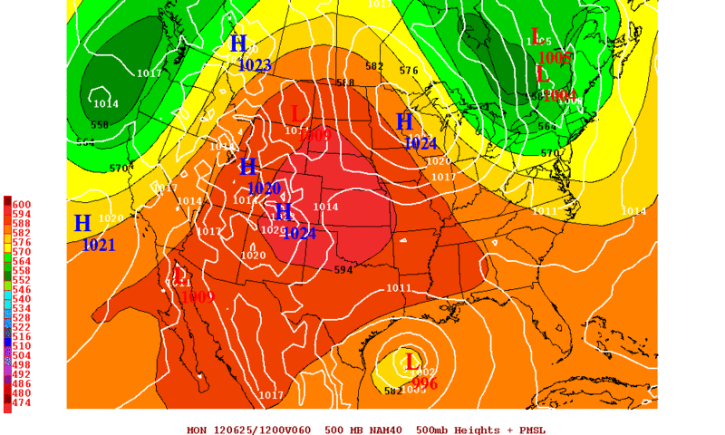
0zNam forecast valid for Monday Morning.....Strongest run yet. Looks like its a tad to fast IMO.
0 likes
The following post is NOT an official forecast and should not be used as such. It is just the opinion of the poster and may or may not be backed by sound meteorological data. It is NOT endorsed by any professional institution including storm2k.org For Official Information please refer to the NHC and NWS products.

Re:
[quote="Rgv20"]0zNam forecast valid for Monday Morning.....Strongest run yet. Looks like its a tad to fast IMO.
that is a lot stronger than any of the runs to date. I have been watching it really closely for the trof position...
that is a lot stronger than any of the runs to date. I have been watching it really closely for the trof position...
0 likes
Re: ATL: INVEST 96L - Discussion
that picture of Claudette  had me fooled for a second....I was like what in the world, I have only been away for a few hours......
0 likes


-
cycloneye
- Admin
- Posts: 149298
- Age: 69
- Joined: Thu Oct 10, 2002 10:54 am
- Location: San Juan, Puerto Rico
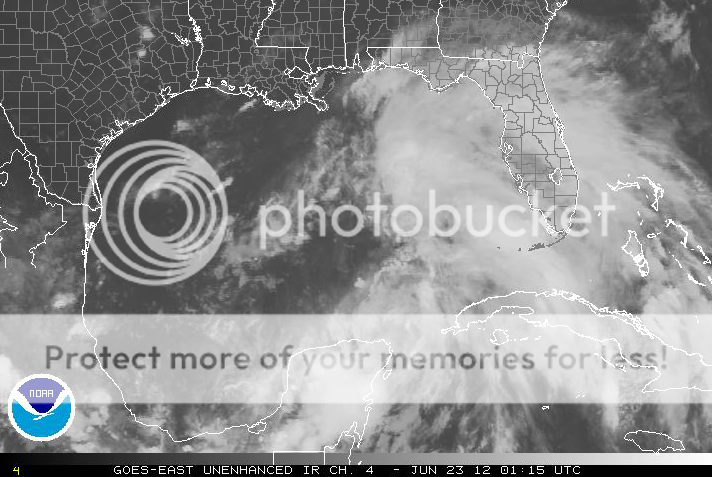
Re: ATL: INVEST 96L - Discussion
The 00z TAFB Surface Analysis.

Uploaded with imageshack.us
Uploaded with imageshack.us
0 likes
Visit the Caribbean-Central America Weather Thread where you can find at first post web cams,radars
and observations from Caribbean basin members Click Here
and observations from Caribbean basin members Click Here
-
Typhoon_Willie

- Category 5
- Posts: 1042
- Joined: Mon Jun 09, 2003 3:19 pm
- Location: Greenacres City, Florida
Re: ATL: INVEST 96L - Models
Looks interesting. We will have to wait and see what developes in the coming days. Models seem to be split as to where this thing goes...
0 likes
-
Rgv20
- S2K Supporter
- Posts: 2466
- Age: 39
- Joined: Wed Jan 05, 2011 5:42 pm
- Location: Edinburg/McAllen Tx
Re: Re:
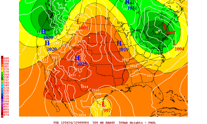
ROCK wrote:that is a lot stronger than any of the runs to date. I have been watching it really closely for the trof position...
Me too I look at the NAM for the 500mb Charts. On a side note the NAM agrees really well with the 12zUKMET and ECMWF. I think the NAM has gotten a little bit better regarding the Tropics (Compare to years past! lol) Anyway it has landfall at Brownsville on Tuesday Morning.
0 likes
The following post is NOT an official forecast and should not be used as such. It is just the opinion of the poster and may or may not be backed by sound meteorological data. It is NOT endorsed by any professional institution including storm2k.org For Official Information please refer to the NHC and NWS products.
Who is online
Users browsing this forum: No registered users and 87 guests