ATL: INVEST 90L
Moderator: S2k Moderators

-
cycloneye

- Admin

- Posts: 139210
- Age: 67
- Joined: Thu Oct 10, 2002 10:54 am
- Location: San Juan, Puerto Rico
Re: ATL: INVEST 90L
Dr Jeff Masters take on this invest.
OK, this is officially nuts. We've got the first Super Sunday Invest in history. You'd think I could have a nice quiet Super Sunday not thinking about blogging about something in the tropics, but NOOOO! I'll be interested to see the SHIPS model forecast when it comes out in another hour or so. 90L likely doesn't have time to develop into a named storm, but definitely has the potential get more organized. Shear is 20 - 25 knots, and both the GFS and ECMWF models keep the shear below 25 knots through Monday. There is a historical precedent, as some here have pointed out, with the the 1952 Groundhog's Day tropical storm that hit Southwest Florida. According to Wikipedia,
The 1952 Groundhog Day Storm was the only Atlantic tropical cyclone on record in the month of February. First observed in the western Caribbean Sea on February 2, it moved rapidly throughout its duration and struck southwestern Florida within 24 hours of forming. In the state, the winds damaged some crops and power lines, but no serious damage was reported.
Jeff Masters
0 likes
Visit the Caribbean-Central America Weather Thread where you can find at first post web cams,radars
and observations from Caribbean basin members Click Here
and observations from Caribbean basin members Click Here
-
cycloneye
- Admin
- Posts: 139210
- Age: 67
- Joined: Thu Oct 10, 2002 10:54 am
- Location: San Juan, Puerto Rico
Re: ATL: INVEST 90L
Is now finnally at NRL.

0 likes
Visit the Caribbean-Central America Weather Thread where you can find at first post web cams,radars
and observations from Caribbean basin members Click Here
and observations from Caribbean basin members Click Here
-
TropicalAnalystwx13

- Category 5

- Posts: 2109
- Age: 26
- Joined: Tue Jul 19, 2011 8:20 pm
- Location: Wilmington, NC
- Contact:
-
cycloneye
- Admin
- Posts: 139210
- Age: 67
- Joined: Thu Oct 10, 2002 10:54 am
- Location: San Juan, Puerto Rico
Re:
TropicalAnalystwx13 wrote:Invest 90L is up on the Navy site and ATCF.
Not yet on atcf site.
ftp://ftp.tpc.ncep.noaa.gov/atcf/tcweb/
0 likes
Visit the Caribbean-Central America Weather Thread where you can find at first post web cams,radars
and observations from Caribbean basin members Click Here
and observations from Caribbean basin members Click Here

The strongest winds and highest winds so far reported by a ship in the Yucatan Channel.
http://www.ndbc.noaa.gov/radial_search. ... t=A&time=8
Code: Select all
ID      T1 TIME    LAT     LON DIST HDG WDIR  WSPD   GST  WVHT
           (GMT)                 nm  °T   °T   kts   kts    ft
SHIP     S 1800  22.20  -86.00   57 282  120  22.9     -   8.2
http://www.ndbc.noaa.gov/radial_search. ... t=A&time=8
0 likes
-
cycloneye
- Admin
- Posts: 139210
- Age: 67
- Joined: Thu Oct 10, 2002 10:54 am
- Location: San Juan, Puerto Rico
Re: ATL: INVEST 90L
Whoa,this is organizing at a good clip!
0 likes
Visit the Caribbean-Central America Weather Thread where you can find at first post web cams,radars
and observations from Caribbean basin members Click Here
and observations from Caribbean basin members Click Here
-
cycloneye
- Admin
- Posts: 139210
- Age: 67
- Joined: Thu Oct 10, 2002 10:54 am
- Location: San Juan, Puerto Rico
Re: ATL: INVEST 90L
This is the marine discussion by NHC.
MARINE WEATHER DISCUSSION
NWS NATIONAL HURRICANE CENTER MIAMI FL
225 PM EST SUN FEB 05 2012
MARINE WEATHER DISCUSSION FOR THE GULF OF MEXICO...CARIBBEAN SEA
AND SOUTHWEST NORTH ATLC S OF 31N W OF 55W.
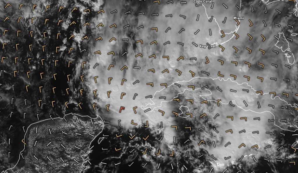
AS FOR THE YUCATAN CHANNEL DISTURBANCE...SRN STREAM NEGATIVE
TILT S/W SHIFTING E-NE ACROSS YUCATAN AND CENTRAL AMERICA TODAY
HAS MOVED OVER LLVL TROFFING IN SAME LOCATION...WITH VIGOROUS
MID LEVEL TURNING SEEN IN WATER VAPOR IMAGERY JUST OFF W TIP OF
CUBA. IR AND VIS IMAGERY SUGGEST LLVL TURNING AND CLOUD LINES
FROM SW TO NE OFF E COAST OF YUCATAN...WITH AN 1800 UTC SHIP OB
OF SE WINDS AT 20 KT DIRECTLY UNDERNEATH APPARENT CYCLONIC
TURNING. FURTHER INSPECTION OF VIS IMAGERY SHOWS A MESO LOW NEAR
23N87W...WHERE WE HAVE PUT A LOW ON SFC MAP...AND ANOTHER LOW OR
TWO ALONG A CONVERGENCE LINE OF CONVECTION EXTENDING NE THEN
E-NE ACROSS THE STRAITS AND TO THE KEYS. MID TO UPPER LEVEL
SUPPORT WILL MOVE NE NEXT FEW DAYS...AND ACROSS S FL MON AND MON
EVENING AND DAMPEN AS IT MOVES INTO MORE LAMINAR FLOW ACROSS THE
BAHAMAS AND ADJACENT ATLC MON NIGHT AND TUE. MODELS HAVE BEEN
HINTING AT SOME SFC DEVELOPMENT PAST SEVERAL DAYS...AND IT
APPEARS OBVIOUS THAT A LOW TO MID LEVEL VORTEX WILL MOVE ACROSS
S FL MON AND MON NIGHT...WITH ASSOCIATED MOISTURE AND CONVECTION
SHIFTING NE ACROSS E SEMICIRCLE. WHETHER OR NOT A SFC LOW IS
REALIZED REMAINS TO BE SEEN...BUT AT THIS TIME AM NOT
ANTICIPATING MORE THAN 20 TO POSSIBLY 25 KT IN A SMALL ZONE
ACROSS N AND NW QUAD OF ANY LOW ASSOCIATED WITH MID LEVEL
SUPPORT. SOME LINGERING TROFFING LIKELY TO PERSIST BEHIND
THROUGH WED. AT THIS TIME...LOOKS LIKE RAINFALL AND POTENTIAL
FOR SEVERE WEATHER ARE MAIN CONCERNS.
http://www.nhc.noaa.gov/text/MIAMIMATS.shtml
MARINE WEATHER DISCUSSION
NWS NATIONAL HURRICANE CENTER MIAMI FL
225 PM EST SUN FEB 05 2012
MARINE WEATHER DISCUSSION FOR THE GULF OF MEXICO...CARIBBEAN SEA
AND SOUTHWEST NORTH ATLC S OF 31N W OF 55W.
AS FOR THE YUCATAN CHANNEL DISTURBANCE...SRN STREAM NEGATIVE
TILT S/W SHIFTING E-NE ACROSS YUCATAN AND CENTRAL AMERICA TODAY
HAS MOVED OVER LLVL TROFFING IN SAME LOCATION...WITH VIGOROUS
MID LEVEL TURNING SEEN IN WATER VAPOR IMAGERY JUST OFF W TIP OF
CUBA. IR AND VIS IMAGERY SUGGEST LLVL TURNING AND CLOUD LINES
FROM SW TO NE OFF E COAST OF YUCATAN...WITH AN 1800 UTC SHIP OB
OF SE WINDS AT 20 KT DIRECTLY UNDERNEATH APPARENT CYCLONIC
TURNING. FURTHER INSPECTION OF VIS IMAGERY SHOWS A MESO LOW NEAR
23N87W...WHERE WE HAVE PUT A LOW ON SFC MAP...AND ANOTHER LOW OR
TWO ALONG A CONVERGENCE LINE OF CONVECTION EXTENDING NE THEN
E-NE ACROSS THE STRAITS AND TO THE KEYS. MID TO UPPER LEVEL
SUPPORT WILL MOVE NE NEXT FEW DAYS...AND ACROSS S FL MON AND MON
EVENING AND DAMPEN AS IT MOVES INTO MORE LAMINAR FLOW ACROSS THE
BAHAMAS AND ADJACENT ATLC MON NIGHT AND TUE. MODELS HAVE BEEN
HINTING AT SOME SFC DEVELOPMENT PAST SEVERAL DAYS...AND IT
APPEARS OBVIOUS THAT A LOW TO MID LEVEL VORTEX WILL MOVE ACROSS
S FL MON AND MON NIGHT...WITH ASSOCIATED MOISTURE AND CONVECTION
SHIFTING NE ACROSS E SEMICIRCLE. WHETHER OR NOT A SFC LOW IS
REALIZED REMAINS TO BE SEEN...BUT AT THIS TIME AM NOT
ANTICIPATING MORE THAN 20 TO POSSIBLY 25 KT IN A SMALL ZONE
ACROSS N AND NW QUAD OF ANY LOW ASSOCIATED WITH MID LEVEL
SUPPORT. SOME LINGERING TROFFING LIKELY TO PERSIST BEHIND
THROUGH WED. AT THIS TIME...LOOKS LIKE RAINFALL AND POTENTIAL
FOR SEVERE WEATHER ARE MAIN CONCERNS.
http://www.nhc.noaa.gov/text/MIAMIMATS.shtml
0 likes
Visit the Caribbean-Central America Weather Thread where you can find at first post web cams,radars
and observations from Caribbean basin members Click Here
and observations from Caribbean basin members Click Here
-
cycloneye
- Admin
- Posts: 139210
- Age: 67
- Joined: Thu Oct 10, 2002 10:54 am
- Location: San Juan, Puerto Rico
Re: ATL: INVEST 90L
Is not the first time in history that something develops in the same area and tracks like this one will do. This is Tropical Storm 1 of 1952.
http://www.wunderground.com/hurricane/at19521.asp
http://www.wunderground.com/hurricane/at19521.asp
0 likes
Visit the Caribbean-Central America Weather Thread where you can find at first post web cams,radars
and observations from Caribbean basin members Click Here
and observations from Caribbean basin members Click Here
-
TropicalAnalystwx13
- Category 5
- Posts: 2109
- Age: 26
- Joined: Tue Jul 19, 2011 8:20 pm
- Location: Wilmington, NC
- Contact:
NOW it's up on the ATCF site:
BEGIN
NHC_ATCF
invest_al902012.invest
FSTDA
R
U
040
010
0000
201202051617
NONE
NOTIFY=ATRP
END
INVEST, AL, L, , , , , 90, 2012, DB, O, 2012020512, 9999999999, , , , , , METWATCH, , AL902012
AL, 90, 2012020500, , BEST, 0, 220N, 860W, 25, 1015, DB, 0, , 0, 0, 0, 0,
AL, 90, 2012020506, , BEST, 0, 220N, 860W, 25, 1015, DB, 0, , 0, 0, 0, 0,
AL, 90, 2012020512, , BEST, 0, 220N, 860W, 25, 1014, LO, 34, NEQ, 0, 0, 0, 0, 1016, 150, 100, 0, 0, L, 0, , 0, 0, INVEST, M,
0 likes
-
northjaxpro

- S2K Supporter

- Posts: 8900
- Joined: Mon Sep 27, 2010 11:21 am
- Location: Jacksonville, FL
HPC now depicts a 1013 mb Low analyzed just north of Cancun as 2 p.m.
http://www.hpc.ncep.noaa.gov/sfc/90fwbg.gif
http://www.hpc.ncep.noaa.gov/sfc/90fwbg.gif
0 likes
NEVER, EVER SAY NEVER in the tropics and weather in general, and most importantly, with life itself!!
________________________________________________________________________________________
Fay 2008 Beryl 2012 Debby 2012 Colin 2016 Hermine 2016 Julia 2016 Matthew 2016 Irma 2017 Dorian 2019
________________________________________________________________________________________
Fay 2008 Beryl 2012 Debby 2012 Colin 2016 Hermine 2016 Julia 2016 Matthew 2016 Irma 2017 Dorian 2019
-
Rgv20

- S2K Supporter
- Posts: 2456
- Age: 37
- Joined: Wed Jan 05, 2011 5:42 pm
- Location: Edinburg/McAllen Tx
18z 850mb vorticity looks really good...had to double check the calender! 
0 likes
The following post is NOT an official forecast and should not be used as such. It is just the opinion of the poster and may or may not be backed by sound meteorological data. It is NOT endorsed by any professional institution including storm2k.org For Official Information please refer to the NHC and NWS products.
-
SFLcane

- S2K Supporter
- Posts: 9615
- Age: 46
- Joined: Sat Jun 05, 2010 1:44 pm
- Location: Lake Worth Florida
Re:
CrazyC83 wrote:What does it need to become a tropical storm?
Looks like some much needed rainfall on the way for S.FL but thats about all she wrote.
Here are some parameters for TC identification...
1) Tropical Disturbance must have persisted for at least 12 hours.
2) It must have an observable circulation that has also persisted for at least 12 hours as well.
3) There is evidence of anticyclonic "outflow" at the upper levels of the Troposhere, that can be observed on Visible satellite imagery as cirrus clouds expanding out away from the circulation.
4) It must have developed a "closed" Center of Circulation (COC). In most cases, the evidence of a "westerly" wind associated with the COC at the surface (i.e. generally within 200 nm miles of the center) signifies the existance of a "closed" COC. Typically, this westerly wind component needs to be at 10 Knots or greater to be considered sufficiently organized.
5) The observation of Maximum Sustained Winds (MSW) of 25 knots or greater at the "surface", associated with the COC.
6) Dvorak satellite intensity estimates of T-Numbers of at least 1.0-1.5 from TAFB and SAB.
All in all TPC will generally classify a disturbance as a TC when the system has maintained persistant deep convection close to its COC for a period of at least 12 hours, combined with a Westerly wind of 25 knots or greater, if a "closed" COC has been detected using the aforementioned satellite tools, recon, or surface obs from land based stations, ships and/or buoys.
Hope that helps.
0 likes


Re: ATL: INVEST 90L
This is a good surprise, a disturbance in February that doesn't seem to be bothering anyone.
0 likes
-
SouthFloridawx

- S2K Supporter
- Posts: 8344
- Age: 45
- Joined: Tue Jul 26, 2005 1:16 am
- Location: Sarasota, FL
- Contact:
Re: ATL: INVEST 90L
0 likes
Re: ATL: INVEST 90L - Models
0 likes
Who is online
Users browsing this forum: No registered users and 49 guests