
ATL: ARTHUR - Post-Tropical - Discussion
Moderator: S2k Moderators
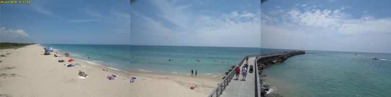
Meanwhile people along the eastern coast of FL have been enjoying a beautiful day along the beaches with surf temps in the mid 80s in most part of central and northern FL, which is very rare for the end of June which most times cold upwelling takes over from Vero Beach northward towards St Augustine this time of the year with SSTs along the immediate coast falling down into the low to mid 70s, something about this year in this part of the Atlantic.
Last edited by NDG on Sun Jun 29, 2014 12:12 pm, edited 1 time in total.
0 likes
-
SFLcane

- S2K Supporter

- Posts: 10281
- Age: 48
- Joined: Sat Jun 05, 2010 1:44 pm
- Location: Lake Worth Florida
Re: ATL: INVEST 91L - Discussion
If you asked me not really sure why recon was cancelled today? Looks fairly well organized with some decent banding. close to a td.
0 likes
-
cycloneye

- Admin

- Posts: 149503
- Age: 69
- Joined: Thu Oct 10, 2002 10:54 am
- Location: San Juan, Puerto Rico
Re: ATL: INVEST 91L - Discussion
ASCAT pass made around 15:00 UTC shows a well defined circulation.

0 likes
Visit the Caribbean-Central America Weather Thread where you can find at first post web cams,radars
and observations from Caribbean basin members Click Here
and observations from Caribbean basin members Click Here
-
TropicalAnalystwx13

- Category 5

- Posts: 2109
- Age: 28
- Joined: Tue Jul 19, 2011 8:20 pm
- Location: Wilmington, NC
- Contact:
Looking close to tropical depression status this afternoon, though I'd like to see some deeper and better sustained convection over the center before the NHC calls it. Should become our first cyclone over the next 24-36 hours. Best shot at intensification will be after its landfall/closest approach to Florida and its recurve northeastward, when it will benefit most from upper-level divergence in association with the approaching trough. A strong tropical storm or hurricane like the ECMWF has been indicating would not surprise me.
0 likes
-
hurricanefloyd5

- Category 5
- Posts: 1659
- Age: 45
- Joined: Sun May 02, 2004 10:53 am
- Location: Spartanburg
- Contact:
Re: ATL: INVEST 91L - Discussion
Let's see tropical depression 1/tropical storm Arthur develop. If this thing meanders with the right conditions this thing Ckrits slowly or moderately strengthened at a decent rate. I hope it develops into Hurricane
0 likes
Re: ATL: INVEST 91L - Discussion
SFLcane wrote:If you asked me not really sure why recon was cancelled today? Looks fairly well organized with some decent banding. close to a td.
I agree that it looks fairly well organized but they probably would had not found strong enough winds at the surface, buoy just to the SW of the circulation is only reporting winds near 20 knots with wave heights only near 3 feet, a good depression most times produces wave heights at least 6' feet reported by buoys close to it.
0 likes
-
tropicwatch

- Category 5
- Posts: 3426
- Age: 62
- Joined: Sat Jun 02, 2007 10:01 am
- Location: The Villages, Florida
- Contact:
Re: ATL: INVEST 91L - Discussion
hurricanefloyd5 wrote:Let's see tropical depression 1/tropical storm Arthur develop. If this thing meanders with the right conditions this thing Ckrits slowly or moderately strengthened at a decent rate. I hope it develops into Hurricane
That easy to say being inland in Orlando.
0 likes
Tropicwatch
Agnes 72', Eloise 75, Elena 85', Kate 85', Charley 86', Florence 88', Beryl 94', Dean 95', Erin 95', Opal 95', Earl 98', Georges 98', Ivan 2004', Arlene 2005', Dennis 2005', Ida 2009' Debby 2012' Irma 2017' Michael 2018'
Agnes 72', Eloise 75, Elena 85', Kate 85', Charley 86', Florence 88', Beryl 94', Dean 95', Erin 95', Opal 95', Earl 98', Georges 98', Ivan 2004', Arlene 2005', Dennis 2005', Ida 2009' Debby 2012' Irma 2017' Michael 2018'
-
cycloneye
- Admin
- Posts: 149503
- Age: 69
- Joined: Thu Oct 10, 2002 10:54 am
- Location: San Juan, Puerto Rico
Re: ATL: INVEST 91L - Discussion
TROPICAL WEATHER OUTLOOK
NWS NATIONAL HURRICANE CENTER MIAMI FL
200 PM EDT SUN JUN 29 2014
For the North Atlantic...Caribbean Sea and the Gulf of Mexico:
Satellite wind data and surface observations indicate that the low
pressure system located about 230 miles east of St. Augustine,
Florida, is gradually becoming better defined as it moves slowly
southward to southwestward. Although upper-level winds are only
marginally favorable, a tropical depression could still form during
the next day or two. However, the system's proximity to dry air
could inhibit significant development until environmental conditions
become more conducive by late Tuesday while the low meanders
offshore of the Florida east coast. The Air Force Reserve
reconnaissance aircraft that was scheduled to investigate the
disturbance this afternoon has been canceled, and the flight has
been rescheduled for Monday morning, if necessary.
* Formation chance through 48 hours...high...60 percent.
* Formation chance through 5 days...high...80 percent.
$$
Forecaster Stewart
0 likes
Visit the Caribbean-Central America Weather Thread where you can find at first post web cams,radars
and observations from Caribbean basin members Click Here
and observations from Caribbean basin members Click Here
-
tropicwatch
- Category 5
- Posts: 3426
- Age: 62
- Joined: Sat Jun 02, 2007 10:01 am
- Location: The Villages, Florida
- Contact:
With the NHC upping the percentages at the 2pm TWO, I am kind of surprised today's mission was canceled.
0 likes
Tropicwatch
Agnes 72', Eloise 75, Elena 85', Kate 85', Charley 86', Florence 88', Beryl 94', Dean 95', Erin 95', Opal 95', Earl 98', Georges 98', Ivan 2004', Arlene 2005', Dennis 2005', Ida 2009' Debby 2012' Irma 2017' Michael 2018'
Agnes 72', Eloise 75, Elena 85', Kate 85', Charley 86', Florence 88', Beryl 94', Dean 95', Erin 95', Opal 95', Earl 98', Georges 98', Ivan 2004', Arlene 2005', Dennis 2005', Ida 2009' Debby 2012' Irma 2017' Michael 2018'
-
gatorcane

- S2K Supporter
- Posts: 23708
- Age: 48
- Joined: Sun Mar 13, 2005 3:54 pm
- Location: Boca Raton, FL
Re: ATL: INVEST 91L - Discussion
AJC3 wrote:This should make a pretty close pass to NOAA Buoy 41010 (28.90N, 78.46W) during the next 24-36 hours.
http://www.ndbc.noaa.gov/station_page.php?station=41010
Noticeable increase in the wind speed at this buoy. Wave height (not shown) around 3.3 feet and gradually increasing. Suspect the pressure will be gradually dropping over the next 24-36 hours as 91L nears:

0 likes

Re: ATL: INVEST 91L - Discussion
It would still be a reasonable assumption that if it becomes well enough organized beforehand, they could upgrade the system to at least a depression prior to recon going out, then adjust the intensity accordingly depending on what they find.
0 likes
The above post is not official and should not be used as such. It is the opinion of the poster and may or may not be backed by sound meteorological data. It is not endorsed by any professional institution or storm2k.org. For official information, please refer to the NHC and NWS products.
-
'CaneFreak

- Category 5
- Posts: 1487
- Joined: Mon Jun 05, 2006 10:50 am
- Location: New Bern, NC
-
cycloneye
- Admin
- Posts: 149503
- Age: 69
- Joined: Thu Oct 10, 2002 10:54 am
- Location: San Juan, Puerto Rico
Re: ATL: INVEST 91L - Discussion
18z Best Track:
AL, 91, 2014062918, , BEST, 0, 296N, 773W, 25, 1015, LO
AL, 91, 2014062918, , BEST, 0, 296N, 773W, 25, 1015, LO
0 likes
Visit the Caribbean-Central America Weather Thread where you can find at first post web cams,radars
and observations from Caribbean basin members Click Here
and observations from Caribbean basin members Click Here
-
SFLcane
- S2K Supporter
- Posts: 10281
- Age: 48
- Joined: Sat Jun 05, 2010 1:44 pm
- Location: Lake Worth Florida
Re: ATL: INVEST 91L - Discussion
Good loop here speed up. Fairly impressive LLC heading into gulfstream.
http://climate.cod.edu/flanis/satellite ... tic-vis-48
http://climate.cod.edu/flanis/satellite ... tic-vis-48
0 likes
-
Ikester
- Professional-Met

- Posts: 361
- Age: 40
- Joined: Mon Jun 21, 2010 5:00 pm
- Location: Jacksonville, FL
Re: ATL: INVEST 91L - Discussion
cycloneye wrote:ASCAT pass made around 15:00 UTC shows a well defined circulation.
Here's some food for thought: systems in the southern BOC seem to organize quickly with little time for deepening. While conditions in the gulf are conducive for development most of the time with warm waters and hospitable atmosphere, that isn't always the case yet time and time again we see storms go from disturbance to moderate tropical storm in no time. The reason? The shape of the coastline. I was speaking to Bill Read, former NHC director, about this and he seemed to think that there may be some truth to this....that the shape of the coastline perhaps helps with vorticity. Dr. Neil Frank upon a conversation with him a few years ago, seemed to think there might be something there as well.
That said, if you look at the shape of the east coast, Invest 91L is sitting in a similar area with a very rounded, concave coast. I just wonder if, IF, that has any effect, albeit a subtle, minor one, in the development chances of this system. Thoughts? I'm a young, inexperienced meteorologist so be gentle lol.
0 likes
-
SeGaBob
-
srainhoutx

- S2K Supporter
- Posts: 6919
- Age: 68
- Joined: Sun Jan 14, 2007 11:34 am
- Location: Haywood County, NC
- Contact:
Re: ATL: INVEST 91L - Discussion
Ikester wrote:cycloneye wrote:ASCAT pass made around 15:00 UTC shows a well defined circulation.
Here's some food for thought: systems in the southern BOC seem to organize quickly with little time for deepening. While conditions in the gulf are conducive for development most of the time with warm waters and hospitable atmosphere, that isn't always the case yet time and time again we see storms go from disturbance to moderate tropical storm in no time. The reason? The shape of the coastline. I was speaking to Bill Read, former NHC director, about this and he seemed to think that there may be some truth to this....that the shape of the coastline perhaps helps with vorticity. Dr. Neil Frank upon a conversation with him a few years ago, seemed to think there might be something there as well.
That said, if you look at the shape of the east coast, Invest 91L is sitting in a similar area with a very rounded, concave coast. I just wonder if, IF, that has any effect, albeit a subtle, minor one, in the development chances of this system. Thoughts? I'm a young, inexperienced meteorologist so be gentle lol.
Several things make the BoC unique other than a curved coastline. One big influence is the Ismuthus of Tehuantepec and wind gap events crossing either from the EPAC that assist rapid development via pressure falls and increased low level vorticity. The exact opposite conditions occur when we see high pressures across the SW Gulf flow across the Ismuthus and assist rapid cyclone development near the Gulf Of Tehuantepec in the EPAC. Remember there are some rather high mountain ranges near the area as well.
0 likes
Carla/Alicia/Jerry(In The Eye)/Michelle/Charley/Ivan/Dennis/Katrina/Rita/Wilma/Ike/Harvey
Member: National Weather Association
Wx Infinity Forums
http://wxinfinity.com/index.php
Facebook.com/WeatherInfinity
Twitter @WeatherInfinity
Member: National Weather Association
Wx Infinity Forums
http://wxinfinity.com/index.php
Facebook.com/WeatherInfinity
Twitter @WeatherInfinity
-
gatorcane
- S2K Supporter
- Posts: 23708
- Age: 48
- Joined: Sun Mar 13, 2005 3:54 pm
- Location: Boca Raton, FL
18Z information. Moving SW now:
At 1800 UTC, 29 June 2014, LOW INVEST (AL91) was located in the North Atlantic basin at 29.6°N and 77.3°W. The current intensity was 25 kt and the center was moving at 5 kt at a bearing of 215 degrees. The minimum central pressure was 1015 mb
http://www.ral.ucar.edu/guidance/realti ... /al912014/
At 1800 UTC, 29 June 2014, LOW INVEST (AL91) was located in the North Atlantic basin at 29.6°N and 77.3°W. The current intensity was 25 kt and the center was moving at 5 kt at a bearing of 215 degrees. The minimum central pressure was 1015 mb
http://www.ral.ucar.edu/guidance/realti ... /al912014/
0 likes
-
USTropics
- Professional-Met
- Posts: 2738
- Joined: Sun Aug 12, 2007 3:45 am
- Location: Florida State University
Re:
SeGaBob wrote:What I don't get is why NHC would cancel the mission but up the chances for development like they did.
I think their reasoning for this is the proximity of a nearby buoy that will be able to determine surface observations, coupled with the slow progression of steering currents and the cost factor involved in flying a mission. I would have preferred to see recon, but I can see the counter argument as well.
0 likes
Who is online
Users browsing this forum: No registered users and 46 guests