ATL: BERTHA - Models
Moderator: S2k Moderators
-
stormlover2013
Re: ATL: INVEST 93L - Models
Models will good a good grasp once something develops, I mean I don't buy any model run untill I see that it's developed, I will say this though euro has been the best model this year but it's not always right.
0 likes
-
MGC

- S2K Supporter

- Posts: 5940
- Joined: Sun Mar 23, 2003 9:05 pm
- Location: Pass Christian MS, or what is left.
Re: ATL: INVEST 93L - Models
I would not get too excited about any model run this far out until the Gulfstream samples the upper air. Lots can change in the coming days. I have lost track of the number of times the models early on have the system recurving too soon. If the models start trending westward with every run we may have to start really paying attention. Who knows, there is even a chance 93L could poof, but with the way it is looking this evening I doubt it.......MGC
0 likes


Re: ATL: INVEST 93L - Models
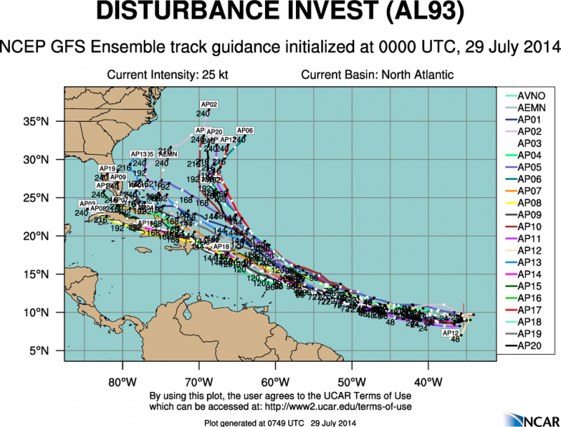
Another look at the 0z ensemble members, you can see that the majority of the members have a more western track while the operational run is with the least members with a track to the right.
0 likes
-
Blown Away

- S2K Supporter
- Posts: 10253
- Joined: Wed May 26, 2004 6:17 am
Re: ATL: INVEST 93L - Models

06z... Farther west...

06z... Big drop off in intensity...

06z...

06z...
Last edited by Blown Away on Tue Jul 29, 2014 7:46 am, edited 3 times in total.
0 likes
Hurricane Eye Experience: David 79, Irene 99, Frances 04, Jeanne 04, Wilma 05… Hurricane Brush Experience: Andrew 92, Erin 95, Floyd 99, Matthew 16, Irma 17, Ian 22, Nicole 22…

-
cycloneye

- Admin

- Posts: 149505
- Age: 69
- Joined: Thu Oct 10, 2002 10:54 am
- Location: San Juan, Puerto Rico
Re: ATL: INVEST 93L - Models
000
WHXX01 KWBC 291250
CHGHUR
TROPICAL CYCLONE GUIDANCE MESSAGE
NWS NATIONAL HURRICANE CENTER MIAMI FL
1250 UTC TUE JUL 29 2014
DISCLAIMER...NUMERICAL MODELS ARE SUBJECT TO LARGE ERRORS.
PLEASE REFER TO NHC OFFICIAL FORECASTS FOR TROPICAL CYCLONE
AND SUBTROPICAL CYCLONE INFORMATION.
ATLANTIC OBJECTIVE AIDS FOR
DISTURBANCE INVEST (AL932014) 20140729 1200 UTC
...00 HRS... ...12 HRS... ...24 HRS... ...36 HRS...
140729 1200 140730 0000 140730 1200 140731 0000
LAT LON LAT LON LAT LON LAT LON
BAMS 9.6N 39.1W 10.2N 42.2W 10.5N 45.6W 10.9N 48.9W
BAMD 9.6N 39.1W 9.8N 41.6W 10.0N 44.0W 10.3N 46.3W
BAMM 9.6N 39.1W 9.8N 41.6W 9.9N 44.1W 10.4N 46.5W
LBAR 9.6N 39.1W 9.5N 42.4W 9.5N 45.7W 9.7N 48.8W
...48 HRS... ...72 HRS... ...96 HRS... ..120 HRS...
140731 1200 140801 1200 140802 1200 140803 1200
LAT LON LAT LON LAT LON LAT LON
BAMS 11.3N 52.0W 12.3N 56.9W 14.7N 62.3W 17.9N 67.8W
BAMD 10.9N 48.4W 12.8N 52.4W 16.0N 56.9W 19.6N 61.2W
BAMM 11.0N 49.0W 13.0N 54.0W 16.5N 59.2W 20.1N 64.2W
LBAR 10.0N 51.7W 10.8N 57.0W 13.3N 61.5W 0.0N 0.0W
...INITIAL CONDITIONS...
LATCUR = 9.6N LONCUR = 39.1W DIRCUR = 270DEG SPDCUR = 17KT
LATM12 = 9.6N LONM12 = 35.5W DIRM12 = 269DEG SPDM12 = 17KT
LATM24 = 9.8N LONM24 = 32.5W
WNDCUR = 30KT RMAXWD = 40NM WNDM12 = 25KT
CENPRS = 1011MB OUTPRS = 1014MB OUTRAD = 100NM SDEPTH = M
RD34NE = 0NM RD34SE = 0NM RD34SW = 0NM RD34NW = 0NM
0 likes
Visit the Caribbean-Central America Weather Thread where you can find at first post web cams,radars
and observations from Caribbean basin members Click Here
and observations from Caribbean basin members Click Here
Notice that the SHIPS show the easterly shear to stay through the next 24-36 hrs before dropping, the system speeding up might help, IMO.
Code: Select all
*   ATLANTIC SHIPS INTENSITY FORECAST       *
                    * GOES AVAILABLE,       OHC AVAILABLE       *
                    *      INVEST  AL932014  07/29/14  12 UTC   *

TIME (HR)          0     6    12    18    24    36    48    60    72    84    96   108   120
V (KT) NO LAND    30    33    37    40    44    52    61    69    74    78    77    79    79
V (KT) LAND       30    33    37    40    44    52    61    69    74    78    77    79    79
V (KT) LGE mod    30    32    35    37    40    45    52    61    72    80    84    84    82
Storm Type      TROP  TROP  TROP  TROP  TROP  TROP  TROP  TROP  TROP  TROP  TROP  TROP  TROP

SHEAR (KT)        23    23    19    19    21    11     9     3    11    10    12    20    17
SHEAR ADJ (KT)     0     0     2     0     0     3     3     0     1     0     4     0     0
SHEAR DIR         52    57    55    46    40    41     8   342   297   216   209   189   205
SST (C)         27.1  27.1  27.2  27.3  27.5  27.6  27.6  27.6  27.6  27.7  28.0  28.0  28.3
POT. INT. (KT)   127   127   128   129   131   132   133   133   134   135   139   139   143
ADJ. POT. INT.   132   129   129   131   133   134   134   135   135   136   139   136   137
200 MB T (C)   -54.3 -53.6 -53.5 -53.6 -53.5 -53.4 -54.0 -54.2 -54.5 -54.2 -54.1 -53.4 -53.7
TH_E DEV (C)       5     6     6     6     7     7     8     9    10    11    11    12    12
700-500 MB RH     63    60    60    60    59    60    60    56    52    47    45    44    42
GFS VTEX (KT)     11    11    11    11    12    13    16    17    17    17    15    15    15
850 MB ENV VOR    38    36    31    22    18    14    12     7    -4   -17   -37   -43   -64
200 MB DIV        48    19    24    -7   -24   -30   -21     3    15    34    20    39    16
700-850 TADV      -8   -10    -8    -7    -7    -5    -3    -5     0     2     7     5     8
LAND (KM)       1390  1333  1208  1100  1002   867   793   765   703   553   522   179   177
LAT (DEG N)      9.6  xx.x  xx.x  xx.x  xx.x  xx.x  xx.x  xx.x  xx.x  xx.x  xx.x  xx.x  xx.x
LONG(DEG W)     39.1 xxx.x xxx.x xxx.x xxx.x xxx.x xxx.x xxx.x xxx.x xxx.x xxx.x xxx.x xxx.x
STM SPEED (KT)    16    13    13    13    13    13    13    15    16    17    17    16    15
HEAT CONTENT       3     3     4     5     7    31    16    27    25    34    18    37    57

  FORECAST TRACK FROM OFPI      INITIAL HEADING/SPEED (DEG/KT):270/ 17      CX,CY: -16/  0
  T-12 MAX WIND:  25            PRESSURE OF STEERING LEVEL (MB):  522  (MEAN=624)
  GOES IR BRIGHTNESS TEMP. STD DEV.  50-200 KM RAD:  13.5 (MEAN=14.5)
  % GOES IR PIXELS WITH T < -20 C    50-200 KM RAD:  70.0 (MEAN=65.0)
0 likes
-
Blown Away
- S2K Supporter
- Posts: 10253
- Joined: Wed May 26, 2004 6:17 am
Re: ATL: INVEST 93L - Models

12z...

12z... Nearly all the models maintain at least TS status compared to 06z...
0 likes
Hurricane Eye Experience: David 79, Irene 99, Frances 04, Jeanne 04, Wilma 05… Hurricane Brush Experience: Andrew 92, Erin 95, Floyd 99, Matthew 16, Irma 17, Ian 22, Nicole 22…
-
meriland23

- Category 5

- Posts: 1239
- Age: 38
- Joined: Mon Aug 29, 2011 9:29 pm
Is this moving too fast towards the west to develop? I mean last I checked it was RACING.
0 likes
The posts in this forum are NOT official forecast and should not be used as such. They are just the opinion of the poster and may or may not be backed by sound meteorological data. They are NOT endorsed by any professional institution or storm2k.org. For official information, please refer to the NHC and NWS products.
-
jlauderdal
- S2K Supporter
- Posts: 7240
- Joined: Wed May 19, 2004 5:46 am
- Location: NE Fort Lauderdale
- Contact:
Re:
NDG wrote::uarrow: What a change of heart the HWRF has had in less than 24 hrs, just wow!
until the hwrf scores two wins in a season(one could be luck) then it should really be looked at as entertainment only
0 likes
-
Blown Away
- S2K Supporter
- Posts: 10253
- Joined: Wed May 26, 2004 6:17 am
Re: ATL: INVEST 93L - Models

GFS Ensembles...
0 likes
Hurricane Eye Experience: David 79, Irene 99, Frances 04, Jeanne 04, Wilma 05… Hurricane Brush Experience: Andrew 92, Erin 95, Floyd 99, Matthew 16, Irma 17, Ian 22, Nicole 22…
Who is online
Users browsing this forum: No registered users and 24 guests