Beats all I ever stepped in.
Every element known to the topics (dry air, SAL, shear, nino, water temp, ULL, yada yada yada,,,) beats these things down to hardly a discernable circulation... but yet there remains enough circ to recurve.
How did a cat 5 hurricane EVER form... and then how did it hit the mainland US? It now seems virtually impossible.
Thankfully.
ATL: BERTHA - Post-Tropical - Discussion
Moderator: S2k Moderators

Did the center redevelop north/northeast of the previous position?
0 likes
The above post is not official and should not be used as such. It is the opinion of the poster and may or may not be backed by sound meteorological data. It is not endorsed by any professional institution or storm2k.org. For official information, please refer to the NHC and NWS products.
Re: ATL: BERTHA - Tropical Storm - Discussion
Bertha is obviously improving and getting ready to take off IMO.
The posts in this forum are NOT official forecast and should not be used as such. They are just the opinion of the poster and may or may not be backed by sound meteorological data. They are NOT endorsed by any professional institution or storm2k.org. For official information, please refer to the NHC and NWS products.
The posts in this forum are NOT official forecast and should not be used as such. They are just the opinion of the poster and may or may not be backed by sound meteorological data. They are NOT endorsed by any professional institution or storm2k.org. For official information, please refer to the NHC and NWS products.
0 likes

Re:
Frank2 wrote:Per the latest TCD it refers to what was mentioned last evening - for regeneration to occur you need to have something to regenerate - this system was never of that category and is at least partially why any strengthening has now leveled off or ended...
Frank, Bertha has continued to improve and it is moving into an area of even better UL conditions, what makes you think that any strengthening has leveled off?
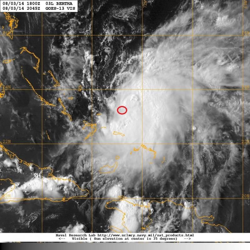
HR Vis loop now shows that her LLC is becoming more defined and getting closer to her MLC.
The circled area is where very clearly her LLC is seen:
0 likes


-
tolakram
- Admin

- Posts: 20186
- Age: 62
- Joined: Sun Aug 27, 2006 8:23 pm
- Location: Florence, KY (name is Mark)
Re: ATL: BERTHA - Tropical Storm - Discussion
Live visible: http://wwwghcc.msfc.nasa.gov/cgi-bin/get-goes?satellite=GOES-E%20CONUS&lat=24&lon=-74&info=vis&zoom=1&width=1000&height=800&quality=95&type=Animation&palette=ir1.pal&numframes=10
Center appears obvious, at least to me, on this loop.
Live IR for after sunset: http://wwwghcc.msfc.nasa.gov/cgi-bin/get-goes?satellite=GOES-E%20CONUS&lat=24&lon=-74&info=ir&zoom=1&width=1000&height=800&quality=95&type=Animation&palette=ir1.pal&numframes=10
color: http://wwwghcc.msfc.nasa.gov/cgi-bin/get-goes?satellite=GOES-E%20CONUS&lat=24&lon=-74&info=ir&zoom=1&width=1000&height=800&quality=95&type=Animation&palette=ir2.pal&numframes=10
0 likes
M a r k
- - - - -
Join us in chat: Storm2K Chatroom Invite. Android and IOS apps also available.
The posts in this forum are NOT official forecasts and should not be used as such. Posts are NOT endorsed by any professional institution or STORM2K.org. For official information and forecasts, please refer to NHC and NWS products.
-
gatorcane

- S2K Supporter

- Posts: 23708
- Age: 48
- Joined: Sun Mar 13, 2005 3:54 pm
- Location: Boca Raton, FL
Re: ATL: BERTHA - Tropical Storm - Discussion
tolakram wrote:Live visible: http://wwwghcc.msfc.nasa.gov/cgi-bin/get-goes?satellite=GOES-E%20CONUS&lat=24&lon=-74&info=vis&zoom=1&width=1000&height=800&quality=95&type=Animation&palette=ir1.pal&numframes=10
Center appears obvious, at least to me, on this loop.
Live IR for after sunset: http://wwwghcc.msfc.nasa.gov/cgi-bin/get-goes?satellite=GOES-E%20CONUS&lat=24&lon=-74&info=ir&zoom=1&width=1000&height=800&quality=95&type=Animation&palette=ir1.pal&numframes=10
color: http://wwwghcc.msfc.nasa.gov/cgi-bin/get-goes?satellite=GOES-E%20CONUS&lat=24&lon=-74&info=ir&zoom=1&width=1000&height=800&quality=95&type=Animation&palette=ir2.pal&numframes=10
Thanks Mark - from these good links you posted, the center is obvious to me too and more so than earlier today. Convection on the increase, warm SSTs, moist environment now, some shear is still around but looks to be lessening.
I am still calling for it to gradually organize further and intensify through the remaining lifetime of this system until it becomes extratropical and/or merges with the mid-latitude front later in the forecast period. NHC forecast looks like a good call to me.
The posts in this forum are NOT official forecast and should not be used as such. They are just the opinion of the poster and may or may not be backed by sound meteorological data. They are NOT endorsed by any professional institution or storm2k.org. For official information, please refer to the NHC and NWS products.
0 likes
-
ozonepete
- Professional-Met

- Posts: 4743
- Joined: Mon Sep 07, 2009 3:23 pm
- Location: From Ozone Park, NYC / Now in Brooklyn, NY
Re: ATL: BERTHA - Tropical Storm - Discussion
Kludge wrote:Beats all I ever stepped in.
Every element known to the topics (dry air, SAL, shear, nino, water temp, ULL, yada yada yada,,,) beats these things down to hardly a discernable circulation... but yet there remains enough circ to recurve.
How did a cat 5 hurricane EVER form... and then how did it hit the mainland US? It now seems virtually impossible.
Thankfully.
I'm a little confused about why you think this can't recurve. It's now beginning to improve in organization and is expected to be a strong T.S. east of Hatteras and then possibly a hurricane after that. That is what will be doing the recurve on Wednesday, not a non-tropical entity.
0 likes
-
ConvergenceZone
.gif)
- Category 5

- Posts: 5241
- Joined: Fri Jul 29, 2005 1:40 am
- Location: Northern California
Re: ATL: BERTHA - Tropical Storm - Discussion
ozonepete wrote:Kludge wrote:Beats all I ever stepped in.
Every element known to the topics (dry air, SAL, shear, nino, water temp, ULL, yada yada yada,,,) beats these things down to hardly a discernable circulation... but yet there remains enough circ to recurve.
How did a cat 5 hurricane EVER form... and then how did it hit the mainland US? It now seems virtually impossible.
Thankfully.
I'm a little confused about why you think this can't recurve. It's now beginning to improve in organization and is expected to be a strong T.S. east of Hatteras and then possibly a hurricane after that. That is what will be doing the recurve on Wednesday, not a non-tropical entity.
I think it's because of the assumption that is often presented here that if a system stays really weak, then it tends to move much more westward than if it develops....Perhaps that's not even true, it just seems to be true sometimes.....
Last edited by ConvergenceZone on Sun Aug 03, 2014 5:08 pm, edited 1 time in total.
0 likes
-
TheAustinMan

- Category 5
- Posts: 1060
- Joined: Mon Jul 08, 2013 4:26 pm
- Location: Central TX / United States
NOAA recon has recently documented a pressure of 1005.9 millibars at 15 kt flight level winds, and 1007.3 millibars where flight level winds were calm.
0 likes
Treat my opinions with a grain of salt. For official information see your local weather service.
“It's tough to make predictions, especially about the future.”
“It's tough to make predictions, especially about the future.”
-
MGC

- S2K Supporter
- Posts: 5940
- Joined: Sun Mar 23, 2003 9:05 pm
- Location: Pass Christian MS, or what is left.
Re: ATL: BERTHA - Tropical Storm - Discussion
Many of you wrote Bertha's obituary a bit prematurely the past couple of days ago. The one thing I have learned since watching the tropics since 1964 is to never give up on a system till it has completely dissipated. Such was the case with Bertha....matter of fact, Bertha's best days are still ahead. Bertha will be finally moving into an environment much more conductive to intensification since the system first organized. I'd conjecture that Bertha has an excellent chance to become a hurricane. The little engine that could.......MGC
0 likes
-
Steve820

- Tropical Storm

- Posts: 188
- Age: 26
- Joined: Sat May 17, 2014 8:04 pm
- Location: Southern California
- Contact:
I hope that Bertha might become a hurricane in the long run. It looks like it has the potential! Hopefully the Lesser Antilles didn't receive so much damage.
0 likes
Hurricanes are an amazing natural phenomena. While many are spiraling pits of evil that kill people or cause devastation, some are tame and stay clear of land.
I wish for you to
I wish for you to
-
znel52
Re: ATL: BERTHA - Tropical Storm - Discussion
Some people have been trying to write this storm off since day 1. It's amazing how it has been able to persist through all of the unfavorable conditions it has endured. It has always been interesting to me why one wave like Bertha can persist and then one wave directly behind it going through the same conditions cannot.
0 likes
-
ozonepete
- Professional-Met
- Posts: 4743
- Joined: Mon Sep 07, 2009 3:23 pm
- Location: From Ozone Park, NYC / Now in Brooklyn, NY
Re: ATL: BERTHA - Tropical Storm - Discussion
znel52 wrote:Some people have been trying to write this storm off since day 1. It's amazing how it has been able to persist through all of the unfavorable conditions it has endured. It has always been interesting to me why one wave like Bertha can persist and then one wave directly behind it going through the same conditions cannot.
Yeah it is probably why a lot of us love this stuff - the challenge
0 likes
-
ozonepete
- Professional-Met
- Posts: 4743
- Joined: Mon Sep 07, 2009 3:23 pm
- Location: From Ozone Park, NYC / Now in Brooklyn, NY
Re: ATL: BERTHA - Tropical Storm - Discussion
Convection still increasing. Organization slowly but clearly improving.


0 likes
AF recon finding Bertha a little stronger so far.
231000 2312N 07228W 8425 01612 0171 +153 +153 179036 038 044 011 00
231030 2314N 07228W 8436 01604 0171 +157 +157 183036 036 043 011 00
231100 2315N 07229W 8433 01605 0164 +152 +151 185039 041 042 009 00
231130 2317N 07230W 8434 01602 0153 +158 +157 183042 042 043 007 00
231200 2319N 07231W 8432 01601 0155 +153 +153 180039 041 044 009 00
231230 2321N 07232W 8432 01604 0163 +153 +153 189040 041 044 010 00
231300 2323N 07233W 8432 01600 0164 +157 +157 191041 042 047 017 00
231330 2324N 07233W 8431 01597 0159 +161 +161 191040 041 047 024 00
$$
0 likes

Who is online
Users browsing this forum: No registered users and 12 guests