ATL: BERTHA - Post-Tropical - Discussion
Moderator: S2k Moderators

-
TropicalAnalystwx13

- Category 5

- Posts: 2109
- Age: 28
- Joined: Tue Jul 19, 2011 8:20 pm
- Location: Wilmington, NC
- Contact:

-
ozonepete
- Professional-Met

- Posts: 4743
- Joined: Mon Sep 07, 2009 3:23 pm
- Location: From Ozone Park, NYC / Now in Brooklyn, NY
Re:
TropicalAnalystwx13 wrote:Tropical Storm Bertha has made huge strides in organization today. Model intensity guidance didn't foresee the storm reaching 50kts for another 48 hours or so.
This might make a run at Category 2 intensity in a few days.
Wouldn't surprise me at all.
0 likes

65 mph as of 11pm advisory, forecast to hurricane within 24 hours.
0 likes
The above post is not official and should not be used as such. It is the opinion of the poster and may or may not be backed by sound meteorological data. It is not endorsed by any professional institution or storm2k.org. For official information, please refer to the NHC and NWS products.
Re:
CrazyC83 wrote:Very high pressure for a strong tropical storm too...basically sitting in a ridge?
Pressures across the Atlantic have been running above average so it is surrounded by very high pressures for this time of the year.
0 likes

-
HurricaneTracker2031
- Tropical Storm

- Posts: 248
- Age: 26
- Joined: Fri Jul 19, 2013 7:20 pm
- Location: Pembroke Pines, FL, USA
- Contact:
Re: ATL: BERTHA - Tropical Storm - Discussion
Bertha finally looks better and may become a Hurricane later today... Lets see.. It has a lot of grit!

Synopsis for Bertha and other systems:http://goo.gl/5ugCVz
Personal Forecast Disclaimer:
The posts in this forum are NOT official forecast and should not be used as such. They are just the opinion of the poster and may or may not be backed by sound meteorological data. They are NOT endorsed by any professional institution or storm2k.org. For official information, please refer to the NHC and NWS products.
0 likes
SHORT VERSION OF DISCLAIMER: THIS SITE LINK BELOW IS NOT AN OFFICIAL FORECASTING OFFICE AND SHOULD NOT BE USED TO MAKE ANY EMERGENCY DECISIONS....
http://www.macstropicalweather.weebly.com
http://www.macstropicalweather.weebly.com
-
CrazyC83
- Professional-Met
- Posts: 34315
- Joined: Tue Mar 07, 2006 11:57 pm
- Location: Deep South, for the first time!
Re:
galaxy401 wrote:Will this be the first hurricane with the pressure above 1000 since Danny? Looks very possible.
Most likely. 1000mb would support a hurricane in this environment. The Dvorak base (987) would likely support a Cat 2.
0 likes

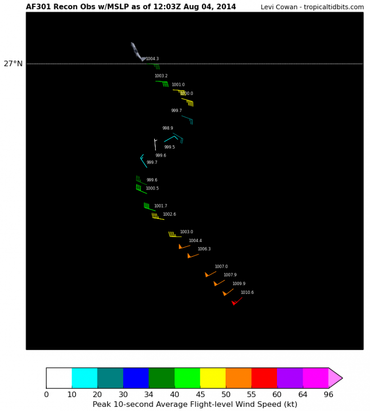
winds seem to be down a bit from the last recon.
0 likes
The above post is not official and should not be used as such. It is the opinion of the poster and may or may not be backed by sound meteorological data. It is not endorsed by any professional institution or storm2k.org. For official information, please refer to the NHC and NWS products.
-
Equilibrium

Got some nice lightening bolts going good sign its intensifying. But yeah Hammy no sign of a 50 knot barb on that ascat pass. I would not read to much into it obviously not as actuate as RECON data .
The posts in this forum are NOT official forecast and should not be used as such. They are just the opinion of the poster and may or may not be backed by sound meteorological data. They are NOT endorsed by any professional institution or storm2k.org. For official information, please refer to the NHC and NWS products.
0 likes
Center may be becoming exposed slightly to the north and the northerly wind shear looks like it's increasing.
0 likes
The above post is not official and should not be used as such. It is the opinion of the poster and may or may not be backed by sound meteorological data. It is not endorsed by any professional institution or storm2k.org. For official information, please refer to the NHC and NWS products.
-
Equilibrium
Its starting to look elongated in the past hour.
The posts in this forum are NOT official forecast and should not be used as such. They are just the opinion of the poster and may or may not be backed by sound meteorological data. They are NOT endorsed by any professional institution or storm2k.org. For official information, please refer to the NHC and NWS products.
The posts in this forum are NOT official forecast and should not be used as such. They are just the opinion of the poster and may or may not be backed by sound meteorological data. They are NOT endorsed by any professional institution or storm2k.org. For official information, please refer to the NHC and NWS products.
0 likes
Another burst of convection and it's up to 70mph with 999mb pressure.
0 likes
The above post is not official and should not be used as such. It is the opinion of the poster and may or may not be backed by sound meteorological data. It is not endorsed by any professional institution or storm2k.org. For official information, please refer to the NHC and NWS products.
-
Dean4Storms
- S2K Supporter

- Posts: 6358
- Age: 63
- Joined: Sun Aug 31, 2003 1:01 pm
- Location: Miramar Bch. FL
-
tolakram
- Admin

- Posts: 20186
- Age: 62
- Joined: Sun Aug 27, 2006 8:23 pm
- Location: Florence, KY (name is Mark)
Re: ATL: BERTHA - Tropical Storm - Discussion
live visible: http://wwwghcc.msfc.nasa.gov/cgi-bin/get-goes?satellite=GOES-E%20CONUS&lat=27&lon=-74&info=vis&zoom=1&width=1000&height=800&quality=95&type=Animation&palette=ir1.pal&numframes=5
zoomed out: http://wwwghcc.msfc.nasa.gov/cgi-bin/get-goes?satellite=GOES-E%20CONUS&lat=27&lon=-74&info=vis&zoom=2&width=1000&height=800&quality=95&type=Animation&palette=ir1.pal&numframes=5
I see low level clouds moving away from Bertha, though I can also see inflow from the west. Overall it doesn't give the impression of a very strong organized storm.
0 likes
M a r k
- - - - -
Join us in chat: Storm2K Chatroom Invite. Android and IOS apps also available.
The posts in this forum are NOT official forecasts and should not be used as such. Posts are NOT endorsed by any professional institution or STORM2K.org. For official information and forecasts, please refer to NHC and NWS products.
Who is online
Users browsing this forum: No registered users and 9 guests