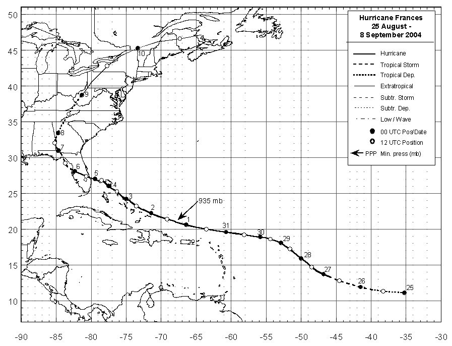
http://www.nhc.noaa.gov/prelims/2004frances1.gif
Reminds me of Hurricane Frances track in '04. Remember her well, uprooted an big old oak in our back yard when she sliced across west central Fla as a TS. But she hit the east coast as a 'cane.
ATL: CRISTOBAL - Models
Moderator: S2k Moderators
-
dixiebreeze

- S2K Supporter

- Posts: 5140
- Joined: Wed Sep 03, 2003 5:07 pm
- Location: crystal river, fla.
Re: ATL: INVEST 96L - Models
0 likes
Re: ATL: INVEST 96L - Models
SFLcane wrote:track of 12z ukmet
Looks smack in my backyard
GFDL looks to be in the same vicinity from an image I saw (not sure if its recent) and if my memory doesn't fail it was the only one who predicted the Katrina dip towards Miami.
0 likes
-
northjaxpro

- S2K Supporter
- Posts: 8900
- Joined: Mon Sep 27, 2010 11:21 am
- Location: Jacksonville, FL
Re: ATL: INVEST 96L - Models
SFLcane wrote:track of 12z ukmet
I know our focus is on 96L, but I had to pause just a moment and give mention to the other notable feature on this UKMET run. Check out the well developed feature closing in on the Leeward Islands 84 hours out. If that verifies, we may have our next system brewing out there.
Back to 96L. Just wanted to mention.
0 likes
NEVER, EVER SAY NEVER in the tropics and weather in general, and most importantly, with life itself!!
________________________________________________________________________________________
Fay 2008 Beryl 2012 Debby 2012 Colin 2016 Hermine 2016 Julia 2016 Matthew 2016 Irma 2017 Dorian 2019
________________________________________________________________________________________
Fay 2008 Beryl 2012 Debby 2012 Colin 2016 Hermine 2016 Julia 2016 Matthew 2016 Irma 2017 Dorian 2019
-
Jevo

- S2K Supporter
- Posts: 1729
- Age: 47
- Joined: Tue Aug 03, 2004 8:45 pm
- Location: The Flemish Cap
- Contact:
This is the 12z GFDL 126 hour Wind Swath for the person that asked

+114

+126 - End of Run

+114
+126 - End of Run
Last edited by Jevo on Sat Aug 23, 2014 3:12 pm, edited 4 times in total.
0 likes
Disclaimer: 50% of the time I have no clue of what I am talking about. Chances are I am taking a less than educated guess that sounds good because 10 years ago I stole Mike Watkins book 'The Hurricane and its Impact'. For official information please direct yourself to the NHC and their cadre of weather geniuses.
-
tolakram
- Admin

- Posts: 20186
- Age: 62
- Joined: Sun Aug 27, 2006 8:23 pm
- Location: Florence, KY (name is Mark)
Re: ATL: INVEST 96L - Models
Someone earlier wanted the HWRF graphic?
last frame, headed NE.

last frame, headed NE.
0 likes
M a r k
- - - - -
Join us in chat: Storm2K Chatroom Invite. Android and IOS apps also available.
The posts in this forum are NOT official forecasts and should not be used as such. Posts are NOT endorsed by any professional institution or STORM2K.org. For official information and forecasts, please refer to NHC and NWS products.
-
gulf701
- Tropical Depression

- Posts: 65
- Age: 76
- Joined: Mon Jun 14, 2010 4:43 pm
- Location: Wewahitchka, FL
Located on the Gulf Coast of the Florida Panhandle, the Eastern tracks were welcome, especially when they look to be a fish. Then some of the models began to shift west even if they were not the more reliable models and it appears that the western trend is a possibility and not just a one time occurrence. Without a COC, it appears that the models are reacting to the existing data and that the trough has taken the weaker path with a lessen impact on 96L. Got to feel for the experts when they are expected to make the track forecast when the controlling factors are so weak.
Personal Forecast Disclaimer:
The posts in this forum are NOT official forecast and should not be used as such. They are just the opinion of the poster and may or may not be backed by sound meteorological data. They are NOT endorsed by any professional institution or storm2k.org. For official information, please refer to the NHC and NWS products.
0 likes
-
gatorcane

- S2K Supporter
- Posts: 23708
- Age: 48
- Joined: Sun Mar 13, 2005 3:54 pm
- Location: Boca Raton, FL
Still not real consensus here but the GFDL model seems to be somewhere in between all of these. Most reliable models still east of Florida. Some models are into Florida still. The BAMD likes Tampa:

Last edited by gatorcane on Sat Aug 23, 2014 3:14 pm, edited 1 time in total.
0 likes
-
meriland23

- Category 5

- Posts: 1239
- Age: 38
- Joined: Mon Aug 29, 2011 9:29 pm
Re: ATL: INVEST 96L - Models
IMO I'm thinking it will do one of three things. 1: hit SE FL 2: hit the outter banks 3: creep up the NE coast ...this is just a opinion tho.
0 likes
The posts in this forum are NOT official forecast and should not be used as such. They are just the opinion of the poster and may or may not be backed by sound meteorological data. They are NOT endorsed by any professional institution or storm2k.org. For official information, please refer to the NHC and NWS products.
-
Jevo
- S2K Supporter
- Posts: 1729
- Age: 47
- Joined: Tue Aug 03, 2004 8:45 pm
- Location: The Flemish Cap
- Contact:
Re:
gatorcane wrote:Still not real consensus here but the HWRF model seems to be somewhere in between all of these. Most reliable models still east of Florida. Some models are into Florida still. The BAMD likes Tampa:
The one thing they all agree on is a recurve...... Where oh where will it be is the question
0 likes
Disclaimer: 50% of the time I have no clue of what I am talking about. Chances are I am taking a less than educated guess that sounds good because 10 years ago I stole Mike Watkins book 'The Hurricane and its Impact'. For official information please direct yourself to the NHC and their cadre of weather geniuses.
-
Bocadude85

- Category 5
- Posts: 2991
- Age: 39
- Joined: Mon Apr 18, 2005 2:20 pm
- Location: Honolulu,Hi
Re:
gatorcane wrote:Still not real consensus here but the GFDL model seems to be somewhere in between all of these. Most reliable models still east of Florida. Some models are into Florida still. The BAMD likes Tampa:
It looks like the fork in the road for the models is 24 north and 75 west. 96L keeps chugging along so I think by tomorrow we will know which route will be taken.
0 likes


-
northjaxpro
- S2K Supporter
- Posts: 8900
- Joined: Mon Sep 27, 2010 11:21 am
- Location: Jacksonville, FL
The models are going to continue being quite divergent until we can get a center of circulation finally classified by Recon and initialized for the models. I can't recall when has been the last time it has taken this amout of time for Recon to close off a circulation for a system. This is day 3 now since this system was tagged an invest.
Last edited by northjaxpro on Sat Aug 23, 2014 3:20 pm, edited 1 time in total.
0 likes
NEVER, EVER SAY NEVER in the tropics and weather in general, and most importantly, with life itself!!
________________________________________________________________________________________
Fay 2008 Beryl 2012 Debby 2012 Colin 2016 Hermine 2016 Julia 2016 Matthew 2016 Irma 2017 Dorian 2019
________________________________________________________________________________________
Fay 2008 Beryl 2012 Debby 2012 Colin 2016 Hermine 2016 Julia 2016 Matthew 2016 Irma 2017 Dorian 2019
-
Bocadude85
- Category 5
- Posts: 2991
- Age: 39
- Joined: Mon Apr 18, 2005 2:20 pm
- Location: Honolulu,Hi
Re: ATL: INVEST 96L - Models
SFLcane wrote:ECM ensemble plenty over fl...
That's the most agreement we have seen from the Euro ensembles thus far...interesting.
0 likes
-
DESTRUCTION5

- Category 5
- Posts: 4430
- Age: 44
- Joined: Wed Sep 03, 2003 11:25 am
- Location: Stuart, FL
Re:
gatorcane wrote:Still not real consensus here but the GFDL model seems to be somewhere in between all of these. Most reliable models still east of Florida. Some models are into Florida still. The BAMD likes Tampa:
Patterns been 18z and 6z into FL and 00z and 12z E of FL..Somethings gotta give...If pattern continues 18z should be showing another landfall.
0 likes
GATOR NATION IS E V E R Y W H E R E !
-
gatorcane
- S2K Supporter
- Posts: 23708
- Age: 48
- Joined: Sun Mar 13, 2005 3:54 pm
- Location: Boca Raton, FL
Re: ATL: INVEST 96L - Models
SFLcane wrote:ECM ensemble plenty over fl...
http://i59.tinypic.com/2dv7dk5.jpg
That is very interesting, pretty good agreement here too. Wonder if the ECMWF operational may finally shift over for the 00Z run? It has been very reluctant and keeps showing recurve east of Florida.
0 likes

-
Blown Away

- S2K Supporter
- Posts: 10253
- Joined: Wed May 26, 2004 6:17 am
Re:
gatorcane wrote:So we have the GFS and ECMWF ensembles starting to zero in on Florida, getting even more interesting!
What keeps that TVCN consensus so constant with a recurve well off SFL?
0 likes
Hurricane Eye Experience: David 79, Irene 99, Frances 04, Jeanne 04, Wilma 05… Hurricane Brush Experience: Andrew 92, Erin 95, Floyd 99, Matthew 16, Irma 17, Ian 22, Nicole 22…
-
tolakram
- Admin
- Posts: 20186
- Age: 62
- Joined: Sun Aug 27, 2006 8:23 pm
- Location: Florence, KY (name is Mark)
Re: Re:
TheStormExpert wrote:gatorcane wrote:So we have the GFS and ECMWF ensembles starting to zero in on Florida, getting even more interesting!
Never really understood these ensembles, what is their purpose and meaning?
Multiple runs of the model with slightly different input parameters. Gives an idea of what will happen if something changes. If the ensembles are tightly clustered then model confidence is high, if they are spread out then there's a chance that if the upper air pattern changes, or some other parameter, the track could change significantly.
0 likes
M a r k
- - - - -
Join us in chat: Storm2K Chatroom Invite. Android and IOS apps also available.
The posts in this forum are NOT official forecasts and should not be used as such. Posts are NOT endorsed by any professional institution or STORM2K.org. For official information and forecasts, please refer to NHC and NWS products.
- - - - -
Join us in chat: Storm2K Chatroom Invite. Android and IOS apps also available.
The posts in this forum are NOT official forecasts and should not be used as such. Posts are NOT endorsed by any professional institution or STORM2K.org. For official information and forecasts, please refer to NHC and NWS products.
Who is online
Users browsing this forum: No registered users and 13 guests