ATL: BERTHA - Post-Tropical - Discussion
Moderator: S2k Moderators
Re: ATL: INVEST 93L - Discussion
A few of us mentioned the easterly shear issue last evening as well - easterly then the possibility of westerly shear once it moves closer to the islands...
0 likes
-
wxman57

- Moderator-Pro Met

- Posts: 23175
- Age: 68
- Joined: Sat Jun 21, 2003 8:06 pm
- Location: Houston, TX (southwest)
Re:
TropicalAnalystwx13 wrote:This has met the criteria of a tropical cyclone for the past 10-12 hours now. I'm not sure why this hasn't been declared by the NHC.
It needs a well-defined LLC and organized convection near the center.
0 likes

Invest 93L continues to become better organized this morning and would not be surprised to see TD 3 later today. Most models still show a recurve away from the Caribbean this morning. Also of interest is the tropical wave behind Invest93L which is showing some signs of organization. I would not be surprised if this wave becomes our next Atl Invest over the next several days.
0 likes
The following post is NOT an official forecast and should not be used as such. It is just the opinion of the poster and may or may not be backed by sound meteorological data. It is NOT endorsed by any professional institution including storm2k.org For Official Information please refer to the NHC and NWS products.
-
TropicalAnalystwx13

- Category 5

- Posts: 2109
- Age: 28
- Joined: Tue Jul 19, 2011 8:20 pm
- Location: Wilmington, NC
- Contact:
Re: Re:
wxman57 wrote:TropicalAnalystwx13 wrote:This has met the criteria of a tropical cyclone for the past 10-12 hours now. I'm not sure why this hasn't been declared by the NHC.
It needs a well-defined LLC and organized convection near the center.
It has both. Deep convection has sustained itself since yesterday afternoon, with banding features in the southern semicircle. The 0011z ASCAT showed a well defined and closed center.
I understand there's no rush to designate it since it's far from land, but if it meets their own criteria..
0 likes
-
tropicwatch

- Category 5
- Posts: 3426
- Age: 62
- Joined: Sat Jun 02, 2007 10:01 am
- Location: The Villages, Florida
- Contact:
Re: ATL: INVEST 93L - Discussion
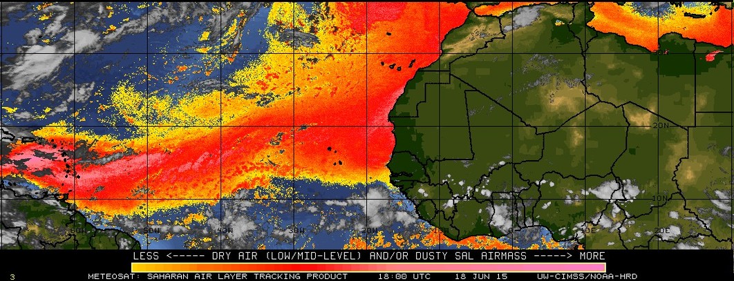
It certainly looks like 93 is dealing with a little more dry air and wind shear this morning.

0 likes
Tropicwatch
Agnes 72', Eloise 75, Elena 85', Kate 85', Charley 86', Florence 88', Beryl 94', Dean 95', Erin 95', Opal 95', Earl 98', Georges 98', Ivan 2004', Arlene 2005', Dennis 2005', Ida 2009' Debby 2012' Irma 2017' Michael 2018'
Agnes 72', Eloise 75, Elena 85', Kate 85', Charley 86', Florence 88', Beryl 94', Dean 95', Erin 95', Opal 95', Earl 98', Georges 98', Ivan 2004', Arlene 2005', Dennis 2005', Ida 2009' Debby 2012' Irma 2017' Michael 2018'
-
TheStormExpert


-
TheStormExpert
-
TheStormExpert
-
cycloneye

- Admin

- Posts: 149550
- Age: 69
- Joined: Thu Oct 10, 2002 10:54 am
- Location: San Juan, Puerto Rico
Re: ATL: INVEST 93L - Discussion
TROPICAL WEATHER OUTLOOK
NWS NATIONAL HURRICANE CENTER MIAMI FL
800 AM EDT TUE JUL 29 2014
For the North Atlantic...Caribbean Sea and the Gulf of Mexico:
Satellite images indicate that showers and thunderstorms
associated with an area of low pressure located about 1600 miles
east of the southern Windward Islands continue to become better
organized. This system could develop into a tropical depression
later today or tomorrow while it moves westward or
west-northwestward at 10 to 15 mph.
* Formation chance through 48 hours...high...70 percent.
* Formation chance through 5 days...high...80 percent.
$$
Forecaster Pasch
0 likes
Visit the Caribbean-Central America Weather Thread where you can find at first post web cams,radars
and observations from Caribbean basin members Click Here
and observations from Caribbean basin members Click Here
-
Blown Away

- S2K Supporter

- Posts: 10253
- Joined: Wed May 26, 2004 6:17 am
Re: ATL: INVEST 93L - Discussion

Looks like those hostile conditions in the MDR again...
0 likes
Hurricane Eye Experience: David 79, Irene 99, Frances 04, Jeanne 04, Wilma 05… Hurricane Brush Experience: Andrew 92, Erin 95, Floyd 99, Matthew 16, Irma 17, Ian 22, Nicole 22…
-
TheStormExpert
-
TheStormExpert
Re: ATL: INVEST 93L - Discussion
Blown Away wrote:
Looks like those hostile conditions in the MDR again...J/K
Joe Bastardi has the right thinking, IMO. As of this morning it's looking more and more as this will take a similar fate as of which Chantal and Dorian from last year did and struggle to survive after a few days.
0 likes
-
tropicwatch
- Category 5
- Posts: 3426
- Age: 62
- Joined: Sat Jun 02, 2007 10:01 am
- Location: The Villages, Florida
- Contact:
Re:
TheStormExpert wrote::uarrow: The 8am TWO looks just like a copy and paste of the 2am TWO.
In no way is this thing better organized than it was 6hrs. ago!
The banding features might be a part of why it is considered better organized. Its just that the moisture has diminished somewhat due to dry air intrusion and wind shear. JMO!
0 likes
Tropicwatch
Agnes 72', Eloise 75, Elena 85', Kate 85', Charley 86', Florence 88', Beryl 94', Dean 95', Erin 95', Opal 95', Earl 98', Georges 98', Ivan 2004', Arlene 2005', Dennis 2005', Ida 2009' Debby 2012' Irma 2017' Michael 2018'
Agnes 72', Eloise 75, Elena 85', Kate 85', Charley 86', Florence 88', Beryl 94', Dean 95', Erin 95', Opal 95', Earl 98', Georges 98', Ivan 2004', Arlene 2005', Dennis 2005', Ida 2009' Debby 2012' Irma 2017' Michael 2018'
-
tolakram
- Admin
- Posts: 20186
- Age: 62
- Joined: Sun Aug 27, 2006 8:23 pm
- Location: Florence, KY (name is Mark)
Re: ATL: INVEST 93L - Discussion
0 likes
M a r k
- - - - -
Join us in chat: Storm2K Chatroom Invite. Android and IOS apps also available.
The posts in this forum are NOT official forecasts and should not be used as such. Posts are NOT endorsed by any professional institution or STORM2K.org. For official information and forecasts, please refer to NHC and NWS products.
-
tolakram
- Admin
- Posts: 20186
- Age: 62
- Joined: Sun Aug 27, 2006 8:23 pm
- Location: Florence, KY (name is Mark)
Re: ATL: INVEST 93L - Discussion
From the Weatherbell pay site, Bastardi has this as a 50kt storm passing just north of Martinique Friday and a 45kt storm crossing over PR Saturday.
You all keep your eyes open.
Personal Forecast Disclaimer:
The posts in this forum are NOT official forecast and should not be used as such. They are just the opinion of the poster and may or may not be backed by sound meteorological data. They are NOT endorsed by any professional institution or storm2k.org. For official information, please refer to the NHC and NWS products.
0 likes
M a r k
- - - - -
Join us in chat: Storm2K Chatroom Invite. Android and IOS apps also available.
The posts in this forum are NOT official forecasts and should not be used as such. Posts are NOT endorsed by any professional institution or STORM2K.org. For official information and forecasts, please refer to NHC and NWS products.
- - - - -
Join us in chat: Storm2K Chatroom Invite. Android and IOS apps also available.
The posts in this forum are NOT official forecasts and should not be used as such. Posts are NOT endorsed by any professional institution or STORM2K.org. For official information and forecasts, please refer to NHC and NWS products.
-
ninel conde
Re: ATL: INVEST 93L - Discussion
Blown Away wrote:
Looks like those hostile conditions in the MDR again...
i dont think it will survive much longer. the horrid conditions have been a multi year trend and they havent changed.
0 likes
-
wxman57
- Moderator-Pro Met
- Posts: 23175
- Age: 68
- Joined: Sat Jun 21, 2003 8:06 pm
- Location: Houston, TX (southwest)
Re: Re:
TropicalAnalystwx13 wrote:wxman57 wrote:TropicalAnalystwx13 wrote:This has met the criteria of a tropical cyclone for the past 10-12 hours now. I'm not sure why this hasn't been declared by the NHC.
It needs a well-defined LLC and organized convection near the center.
It has both. Deep convection has sustained itself since yesterday afternoon, with banding features in the southern semicircle. The 0011z ASCAT showed a well defined and closed center.
I understand there's no rush to designate it since it's far from land, but if it meets their own criteria..
Convection remains quite shallow and is trending weaker, but I think I see a well-defined LLC near 9.5N/38.9W.
0 likes
Who is online
Users browsing this forum: No registered users and 34 guests