ATL: INVEST 92L - Discussion
Moderator: S2k Moderators
-
South Texas Storms

- Professional-Met

- Posts: 4259
- Joined: Thu Jun 24, 2010 12:28 am
- Location: Houston, TX
Re:
TheStormExpert wrote::uarrow: Interesting, btw when does D-Max occur?
D-Max occurs around daybreak.
0 likes

Re: ATL: INVEST 92L - Discussion
92L is already north of South Florida so Central Florida is more of a target
0 likes

Re: ATL: INVEST 92L - Discussion
500mb presentation from 00UTC on CIMMS was still quite poor. It needs much stronger convection than what is showing up now. It is of note that this convection is at least maintaining itself during Dmin so it should help at least keep it going until Dmax unlike last night.
Not unusal to see this pulsating in convection when you have a weak developing system.
Not unusal to see this pulsating in convection when you have a weak developing system.
0 likes
The following post is NOT an official forecast and should not be used as such. It is just the opinion of the poster and may or may not be backed by sound meteorological data. It is NOT endorsed by any professional institution including storm2k.org For Official Information please refer to the NHC and NWS products.
-
Miami Storm Tracker

- Category 4

- Posts: 916
- Age: 68
- Joined: Sun Jun 13, 2010 10:12 pm
- Location: Key Largo, Fla.
- Contact:
Re: ATL: INVEST 92L - Discussion
boca wrote:92L is already north of South Florida so Central Florida is more of a target
Adam First a few pages back mentioned Katrina as a comparison, at the time I felt and thought the COC although weak was south and east of the location Katrina was at that time. But as I see it now he is correct, is this suppose to move due west or wsw like Katrina?
0 likes


Re: ATL: INVEST 92L - Discussion
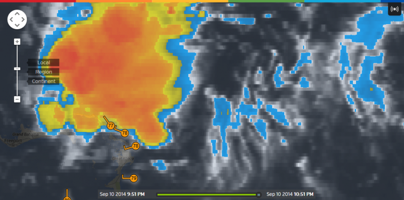
It seems to me that 92L has not moved much this evening, possible weak LLC is just NE of Great Abaco Island, SE of most of the convection going by some of the observations on the island.
0 likes
Re: ATL: INVEST 92L - Discussion
Miami Storm Tracker wrote:boca wrote:92L is already north of South Florida so Central Florida is more of a target
Adam First a few pages back mentioned Katrina as a comparison, at the time I felt and thought the COC although weak was south and east of the location Katrina was at that time. But as I see it now he is correct, is this suppose to move due west or wsw like Katrina?
Hey Dave, it depends on how deep it gets. The deeper system will swing WSW versus a shallower system moving west.
0 likes
The following post is NOT an official forecast and should not be used as such. It is just the opinion of the poster and may or may not be backed by sound meteorological data. It is NOT endorsed by any professional institution including storm2k.org For Official Information please refer to the NHC and NWS products.
-
Miami Storm Tracker
- Category 4
- Posts: 916
- Age: 68
- Joined: Sun Jun 13, 2010 10:12 pm
- Location: Key Largo, Fla.
- Contact:
Re: ATL: INVEST 92L - Discussion
blp wrote:Miami Storm Tracker wrote:boca wrote:92L is already north of South Florida so Central Florida is more of a target
Adam First a few pages back mentioned Katrina as a comparison, at the time I felt and thought the COC although weak was south and east of the location Katrina was at that time. But as I see it now he is correct, is this suppose to move due west or wsw like Katrina?
Hey Dave, it depends on how deep it gets. The deeper system will swing WSW versus a shallower system moving west.
Evening Brian,
looks a bit better than earlier today, just a wait and see if it can hold on to the convection.
0 likes
Re: ATL: INVEST 92L - Discussion
I don't get why NOAA does not put the floater over this. The NASA is OK but not as robust as the NOAA site.
0 likes
The following post is NOT an official forecast and should not be used as such. It is just the opinion of the poster and may or may not be backed by sound meteorological data. It is NOT endorsed by any professional institution including storm2k.org For Official Information please refer to the NHC and NWS products.
-
Bocadude85

- Category 5

- Posts: 2991
- Age: 39
- Joined: Mon Apr 18, 2005 2:20 pm
- Location: Honolulu,Hi
Re: ATL: INVEST 92L - Discussion
At the very least I would think a lot of rain is on its way for us here in Florida
0 likes
Re: ATL: INVEST 92L - Discussion
boca wrote:92L just seems to be sitting there not moving
Yea I think the High is finally building in. You can see the outflow is getting a little flat on the North side.
0 likes
The following post is NOT an official forecast and should not be used as such. It is just the opinion of the poster and may or may not be backed by sound meteorological data. It is NOT endorsed by any professional institution including storm2k.org For Official Information please refer to the NHC and NWS products.
-
Miami Storm Tracker
- Category 4
- Posts: 916
- Age: 68
- Joined: Sun Jun 13, 2010 10:12 pm
- Location: Key Largo, Fla.
- Contact:
Re: ATL: INVEST 92L - Discussion
blp wrote:I don't get why NOAA does not put the floater over this. The NASA is OK but not as robust as the NOAA site.
I agree with you on that, 91L is way out there no threat and has a floater. We have a potential minor threat close to home and no floater.
0 likes
Re: ATL: INVEST 92L - Discussion
Miami Storm Tracker wrote:blp wrote:
Hey Dave, it depends on how deep it gets. The deeper system will swing WSW versus a shallower system moving west.
Evening Brian,
looks a bit better than earlier today, just a wait and see if it can hold on to the convection.
No doubt, the d-max may be fun. I think we may get some nice hot towers.
0 likes
The following post is NOT an official forecast and should not be used as such. It is just the opinion of the poster and may or may not be backed by sound meteorological data. It is NOT endorsed by any professional institution including storm2k.org For Official Information please refer to the NHC and NWS products.
-
Miami Storm Tracker
- Category 4
- Posts: 916
- Age: 68
- Joined: Sun Jun 13, 2010 10:12 pm
- Location: Key Largo, Fla.
- Contact:
Re: ATL: INVEST 92L - Discussion
blp wrote:Miami Storm Tracker wrote:blp wrote:
Hey Dave, it depends on how deep it gets. The deeper system will swing WSW versus a shallower system moving west.
Evening Brian,
looks a bit better than earlier today, just a wait and see if it can hold on to the convection.
No doubt, the d-max may be fun. I think we may get some nice hot towers.
The next set of models should be running soon correct?
0 likes
Re: ATL: INVEST 92L - Discussion
NHC is wise. It doesn't appear to be doing any rapid development.
0 likes

Re: ATL: INVEST 92L - Discussion
I believe the lack of floater is due to a satellite connection issue. Somebody remarked on another site earlier that some sort of transfer was taking place with the connection between two different locations, and its timing coincided with around when the last available floater images are from (~1500 UTC). So hopefully that gets fixed soon.
0 likes
Re: ATL: INVEST 92L - Discussion
Ok, very interesting ASCAT pass from an hour and half ago.

0 likes
The following post is NOT an official forecast and should not be used as such. It is just the opinion of the poster and may or may not be backed by sound meteorological data. It is NOT endorsed by any professional institution including storm2k.org For Official Information please refer to the NHC and NWS products.
-
SouthDadeFish

- Professional-Met
- Posts: 2835
- Joined: Thu Sep 23, 2010 2:54 pm
- Location: Miami, FL
- Contact:

Re: ATL: INVEST 92L - Discussion
SouthDadeFish wrote:If convection persists through the overnight hours, I fail to see why this does not qualify as a TC. I would say NHC would probably wait for recon, but its proximity to land suggests otherwise. Nice low-level structure:
[]http://i.imgur.com/wy4qt1p.jpg[/img]
I agree, that ASCAT pass was pretty convincing to me that whatever was mid-level has worked its way to the surface.
0 likes
The following post is NOT an official forecast and should not be used as such. It is just the opinion of the poster and may or may not be backed by sound meteorological data. It is NOT endorsed by any professional institution including storm2k.org For Official Information please refer to the NHC and NWS products.
Who is online
Users browsing this forum: No registered users and 28 guests