ATL: BERTHA - Post-Tropical - Discussion

Moderator: S2k Moderators

Message
Author
Frank2
Category 5
Category 5
Posts: 4061
Joined: Mon Jul 25, 2005 12:47 pm

Re: ATL: INVEST 93L - Discussion

#201 Postby Frank2 » Tue Jul 29, 2014 7:31 am

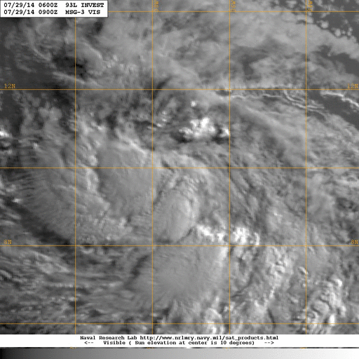
this is in sad shape this morning.

The models continue to trend away from development. The upper easterly shear should allow for the dry air to penetrate the core

still could see something tomorrow, however. Not likely today

and no, this never had a well defined surface circulation


I'm at work and don't have much time to spare but per the pro-met comment above, I'm surprise the NHC mentions the "better organized" term in the latest TWO - the current IR loop shows a lot of dry air to the north and the convection has decreased and is moving westward quickly....

Frank
0 likes   

User avatar
NDG
S2K Supporter
S2K Supporter
Posts: 15446
Joined: Sun Jul 09, 2006 10:14 pm
Location: Orlando, FL

Re: ATL: INVEST 93L - Discussion

#202 Postby NDG » Tue Jul 29, 2014 7:34 am

It may not look as good on satellite as it did yesterday but to me it looks better organized with its circulation tighter.

Image
0 likes   

User avatar
Blown Away
S2K Supporter
S2K Supporter
Posts: 10140
Joined: Wed May 26, 2004 6:17 am

Re: ATL: INVEST 93L - Discussion

#203 Postby Blown Away » Tue Jul 29, 2014 7:35 am

tolakram wrote:From the Weatherbell pay site, Bastardi has this as a 50kt storm passing just north of Martinique Friday and a 45kt storm crossing over PR Saturday.
You all keep your eyes open.


Models trending weaker and 93L is going farther west, possibly over the NE Caribbean as TS, and potentially towards the Bahamas...
0 likes   
Hurricane Eye Experience: David 79, Irene 99, Frances 04, Jeanne 04, Wilma 05... EYE COMING MY WAY IN 2024…
Hurricane Brush Experience: Andrew 92, Erin 95, Floyd 99, Matthew 16, Irma 17, Ian 22, Nicole 22…

znel52

Re: ATL: INVEST 93L - Discussion

#204 Postby znel52 » Tue Jul 29, 2014 7:35 am

Some of the convection has diminished but it doesn't look that bad on visible. Plus it is moving into an area of less dry air and weaker sheer. Bastardi might be a bit bullish but I think we at least get a weak TS out of this. Just an amateur opinion.
0 likes   

User avatar
HurricaneMaster_PR
Category 2
Category 2
Posts: 795
Joined: Tue Jul 22, 2003 6:23 pm
Location: San Juan, Puerto Rico

Re: ATL: INVEST 93L - Discussion

#205 Postby HurricaneMaster_PR » Tue Jul 29, 2014 7:39 am

DATE/TIME LAT LON CLASSIFICATION STORM
29/1145 UTC 9.9N 38.7W T1.5/1.5 93L
29/0545 UTC 9.9N 37.3W T1.0/1.0 93L
28/2345 UTC 9.7N 35.8W T1.0/1.0 93L
0 likes   

User avatar
cycloneye
Admin
Admin
Posts: 143869
Age: 68
Joined: Thu Oct 10, 2002 10:54 am
Location: San Juan, Puerto Rico

Re: ATL: INVEST 93L - Discussion

#206 Postby cycloneye » Tue Jul 29, 2014 7:41 am

Joe Bastardi ‏@BigJoeBastardi · 7m
93L starting to look swell. could be upgraded anytime
0 likes   
Visit the Caribbean-Central America Weather Thread where you can find at first post web cams,radars
and observations from Caribbean basin members Click Here

User avatar
NDG
S2K Supporter
S2K Supporter
Posts: 15446
Joined: Sun Jul 09, 2006 10:14 pm
Location: Orlando, FL

Re: ATL: INVEST 93L - Discussion

#207 Postby NDG » Tue Jul 29, 2014 7:45 am

HurricaneMaster_PR wrote:DATE/TIME LAT LON CLASSIFICATION STORM
29/1145 UTC 9.9N 38.7W T1.5/1.5 93L
29/0545 UTC 9.9N 37.3W T1.0/1.0 93L
28/2345 UTC 9.7N 35.8W T1.0/1.0 93L


Yet another proof that it is getting better organized, some people need to stop slamming the NHC for giving high chances this morning of TD status later today or tomorrow.
0 likes   

User avatar
cycloneye
Admin
Admin
Posts: 143869
Age: 68
Joined: Thu Oct 10, 2002 10:54 am
Location: San Juan, Puerto Rico

Re: ATL: INVEST 93L - Discussion

#208 Postby cycloneye » Tue Jul 29, 2014 7:55 am

12z Best Track.

AL, 93, 2014072912, , BEST, 0, 96N, 391W, 30, 1011, DB
0 likes   
Visit the Caribbean-Central America Weather Thread where you can find at first post web cams,radars
and observations from Caribbean basin members Click Here

User avatar
tropicwatch
Category 5
Category 5
Posts: 3364
Age: 61
Joined: Sat Jun 02, 2007 10:01 am
Location: Panama City Florida
Contact:

#209 Postby tropicwatch » Tue Jul 29, 2014 7:57 am

Surface wind circulation becoming more discernible.

http://earth.nullschool.net/#current/wi ... 8,1.94,571
0 likes   
Tropicwatch


Agnes 72', Eloise 75, Elena 85', Kate 85', Charley 86', Florence 88', Beryl 94', Dean 95', Erin 95', Opal 95', Earl 98', Georges 98', Ivan 2004', Arlene 2005', Dennis 2005', Ida 2009' Debby 2012' Irma 2017' Michael 2018'

User avatar
meriland23
Category 5
Category 5
Posts: 1239
Age: 37
Joined: Mon Aug 29, 2011 9:29 pm

#210 Postby meriland23 » Tue Jul 29, 2014 7:58 am

It looks like the only reason this is taking a westward track according to GFS, etc is because it is going to be assumably weaker. This system is kind of a lose-lose situation for hurricane buffs hoping for something exciting. It is either it gets strong and fishes away or stays extremely weak and makes its way west. Good news for people who don't want any threats or developement too.
0 likes   
The posts in this forum are NOT official forecast and should not be used as such. They are just the opinion of the poster and may or may not be backed by sound meteorological data. They are NOT endorsed by any professional institution or storm2k.org. For official information, please refer to the NHC and NWS products.

User avatar
cycloneye
Admin
Admin
Posts: 143869
Age: 68
Joined: Thu Oct 10, 2002 10:54 am
Location: San Juan, Puerto Rico

Re: ATL: INVEST 93L - Discussion

#211 Postby cycloneye » Tue Jul 29, 2014 8:01 am

Moving a little bit more faster due west at 270 degrees.

LATCUR = 9.6N LONCUR = 39.1W DIRCUR = 270DEG SPDCUR = 17KT
0 likes   
Visit the Caribbean-Central America Weather Thread where you can find at first post web cams,radars
and observations from Caribbean basin members Click Here

Sanibel
Category 5
Category 5
Posts: 10375
Joined: Mon Aug 30, 2004 11:06 pm
Location: Offshore SW Florida

Re: ATL: INVEST 93L - Discussion

#212 Postby Sanibel » Tue Jul 29, 2014 8:01 am

It might have pulled dry air into itself with development.
0 likes   

Frank2
Category 5
Category 5
Posts: 4061
Joined: Mon Jul 25, 2005 12:47 pm

Re: ATL: INVEST 93L - Discussion

#213 Postby Frank2 » Tue Jul 29, 2014 8:21 am

It might have pulled dry air into itself with development.


Yes, old Uncle SAL is to the north in a big way...

Frank
0 likes   

User avatar
NDG
S2K Supporter
S2K Supporter
Posts: 15446
Joined: Sun Jul 09, 2006 10:14 pm
Location: Orlando, FL

#214 Postby NDG » Tue Jul 29, 2014 8:29 am

If 93L would had been declared a TD by now its NHC track would had been very close to the TVCA, TVCN consensus 12z track from this morning.

Image
0 likes   

Alyono
Professional-Met
Professional-Met
Posts: 6961
Joined: Fri Apr 26, 2013 3:52 pm
Location: Texas Coast

#215 Postby Alyono » Tue Jul 29, 2014 8:37 am

not at all convinced this moves north of Martinique until it moves into the Caribbean

Also, the UL north of the Caribbean is moving away
0 likes   

jlauderdal
S2K Supporter
S2K Supporter
Posts: 7177
Joined: Wed May 19, 2004 5:46 am
Location: NE Fort Lauderdale
Contact:

Re: ATL: INVEST 93L - Discussion

#216 Postby jlauderdal » Tue Jul 29, 2014 8:48 am

Blown Away wrote:
tolakram wrote:From the Weatherbell pay site, Bastardi has this as a 50kt storm passing just north of Martinique Friday and a 45kt storm crossing over PR Saturday.
You all keep your eyes open.


Models trending weaker and 93L is going farther west, possibly over the NE Caribbean as TS, and potentially towards the Bahamas...


anything from John Morales this morning.. :roll:
0 likes   

User avatar
cycloneye
Admin
Admin
Posts: 143869
Age: 68
Joined: Thu Oct 10, 2002 10:54 am
Location: San Juan, Puerto Rico

Re: ATL: INVEST 93L - Discussion

#217 Postby cycloneye » Tue Jul 29, 2014 8:49 am

Fresh ASCAT

Image
0 likes   
Visit the Caribbean-Central America Weather Thread where you can find at first post web cams,radars
and observations from Caribbean basin members Click Here

User avatar
NDG
S2K Supporter
S2K Supporter
Posts: 15446
Joined: Sun Jul 09, 2006 10:14 pm
Location: Orlando, FL

#218 Postby NDG » Tue Jul 29, 2014 9:32 am

Saved loop, vigorous circulation taking shape:

Image
0 likes   

User avatar
Gustywind
Category 5
Category 5
Posts: 12334
Joined: Mon Sep 03, 2007 7:29 am
Location: Baie-Mahault, GUADELOUPE

#219 Postby Gustywind » Tue Jul 29, 2014 9:33 am

TROPICAL WEATHER DISCUSSION
NWS NATIONAL HURRICANE CENTER MIAMI FL
805 AM EDT TUE JUL 29 2014

...SPECIAL FEATURE...

A DISTURBANCE OVER THE CENTRAL TROPICAL ATLANTIC HAS BECOME
BETTER ORGANIZED DURING THE PAST SEVERAL HOURS. THE SYSTEM IS
ASSOCIATED WITH A 1010 MB LOW EMBEDDED IN THE MONSOON TROUGH
NEAR 9N37W.
A CLUSTER OF MODERATE CONVECTION IS FROM 8N-11N
BETWEEN 36W-40W. RAINBANDS OF MODERATE CONVECTION ARE ELSEWHERE
FROM 4N-14N BETWEEN 33W-42W. THERE IS A HIGH CHANCE OF FURTHER
DEVELOPMENT OF THIS DISTURBANCE WITHIN 48 HOURS.
SEE THE LATEST
NHC TROPICAL WEATHER OUTLOOK UNDER AWIPS/WMO HEADERS
MIATWOAT/ABNT20 KNHC FOR MORE DETAILS.
0 likes   

Alyono
Professional-Met
Professional-Met
Posts: 6961
Joined: Fri Apr 26, 2013 3:52 pm
Location: Texas Coast

#220 Postby Alyono » Tue Jul 29, 2014 9:36 am

large scale conditions are less favorable today. The favorable phase of the Kelvin wave has passed
0 likes   


Return to “2014”

Who is online

Users browsing this forum: No registered users and 146 guests