
Well, I haven't really taken a look at things for hours but now to see that 93L looks no better than this a.m or yesterday at this time......, I would be really surprised if it were upgraded to a T.D. today or tonight. In spite of its 1001mb pressure, it would seem out of character for NHC to upgrade given its limited convection & appearant convective organization. I suppose it would'nt be such a leap if they were really convinced that upper air conditions were to significantly improve, but outside of glaringly improved conditions I just cant imagine them jumping the gun.
On the topic of the 0Z model ingesting the date from the recon flight, I'd be surprised if the data and center fix were NOT somehow "plugged" into their 0Z forecast.
ATL: Ex NINE
Moderator: S2k Moderators
Re: ATL: INVEST 93L - Discussion
0 likes
Andy D
(For official information, please refer to the NHC and NWS products.)
(For official information, please refer to the NHC and NWS products.)

Re: ATL: INVEST 93L - Discussion
I am not surprised they found a well defined LLC, it was very clearly seen on hr satellite loop, as well as surface pressures were falling day yesterday and this morning across that area. I think the stronger it gets over the next 24-36 hrs or so the better it will survive the track across the Yucatan Peninsula and the stronger it can become in the NW Caribbean.
From the NW Caribbean who knows where it will go it may meander around until a deeper trough picks it up, very common for this time of the year. The further south it stays the more it will stay away from the strongest UL winds.
From the NW Caribbean who knows where it will go it may meander around until a deeper trough picks it up, very common for this time of the year. The further south it stays the more it will stay away from the strongest UL winds.
0 likes
-
AdamFirst

- S2K Supporter

- Posts: 2490
- Age: 36
- Joined: Thu Aug 14, 2008 10:54 am
- Location: Port Saint Lucie, FL
Re: ATL: INVEST 93L - Discussion
AREA FORECAST DISCUSSION
NATIONAL WEATHER SERVICE MIAMI FL
348 PM EDT TUE OCT 21 2014
.DISCUSSION...
A COMPLEX WEATHER PATTERN IS TAKING SHAPE ACROSS THE
AREA. WE CONTINUE TO MONITOR AN AREA OF LOW PRESSURE OVER THE BAY OF
CAMPECHE. THE MODEL CONSENSUS AND NHC SHOWS THAT WHATEVER DEVELOPS
LIKELY WILL REMAIN DISPLACED WELL OFF TO OUR SOUTHWEST THROUGH THE
WEEK. THIS SEEMS MUCH MORE CERTAIN THAN IT DID A FEW DAYS AGO.
HOWEVER, THIS DOES NOT MEAN THAT THE WEATHER WILL NOT BE ACTIVE
ACROSS SOUTH FLORIDA. IT VERY WELL COULD BECOME QUITE ACTIVE
ESPECIALLY THURSDAY THROUGH FRIDAY, BUT THIS IS DEPENDENT ON WHERE
THE FRONTAL BOUNDARY (NOW LOCATED OVER NORTH FLORIDA) SETS UP LATE
THIS WEEK AND HOW FAR NORTH DEEP CARIBBEAN MOISTURE PULLS.
MODELS OVER THE PAST COUPLE OF DAYS HAVE BEEN RATHER INCONSISTENT IN
THE LOCATION OF THE DEEP MOISTURE AXIS AND THE ASSOCIATED HEAVY
RAIN/FLOOD POTENTIAL. SOME RUNS HAVE SHOWN THE MOISTURE AXIS SETTING
UP ACROSS SOUTH FL, WHILE OTHER RUNS HAVE KEPT THE HIGH MOISTURE TO
OUR SOUTH. GIVEN THESE INCONSISTENCIES, THE FORECAST LATE THIS WEEK
REMAINS UNCERTAIN. POPS REMAIN IN THE CHANCE TO LIKELY RANGE THROUGH
FRIDAY BEFORE DECREASING THIS WEEKEND AS THE COLD FRONT MOVES
FURTHER SOUTH AND EAST AWAY FROM THE AREA. SHOULD HEAVY RAINFALL
MATERIALIZE LOCALLY, THE MOST LIKELY TIMEFRAME IS THURSDAY THROUGH
FRIDAY AS SOME MODEL RUNS SHOW A WAVE OF LOW PRESSURE DEVELOPING
ALONG THE FRONT NEARBY JUST TO THE SOUTHEAST.
0 likes
Dolphins Marlins Canes Golden Panthers HEAT
Andrew 1992 - Irene 1999 - Frances 2004 - Jeanne 2004 - Wilma 2005 - Fay 2008 - Isaac 2012 - Matthew 2016 - Irma 2017 - Dorian 2019 - Ian 2022 - Nicole 2022 - Milton 2024
Andrew 1992 - Irene 1999 - Frances 2004 - Jeanne 2004 - Wilma 2005 - Fay 2008 - Isaac 2012 - Matthew 2016 - Irma 2017 - Dorian 2019 - Ian 2022 - Nicole 2022 - Milton 2024
-
cycloneye

- Admin

- Posts: 149291
- Age: 69
- Joined: Thu Oct 10, 2002 10:54 am
- Location: San Juan, Puerto Rico
Re: ATL: INVEST 93L - Discussion
No upgrade at this time.
SPECIAL TROPICAL WEATHER OUTLOOK
NWS NATIONAL HURRICANE CENTER MIAMI FL
425 PM EDT TUE OCT 21 2014
For the North Atlantic...Caribbean Sea and the Gulf of Mexico:
An Air Force Reserve reconnaissance aircraft did find a small well-
defined low in the southern Bay of Campeche. However, the
thunderstorms associated with the low are still not organized enough
for this system to be considered a tropical cyclone. Upper-level
winds could become more conducive for further development by
tomorrow, and this system has the potential to become a tropical
cyclone before it moves inland over the Mexican state of Campeche
late Wednesday or early Thursday. Later in the week, tropical
cyclone formation appears unlikely due to interaction with
a cold front while the system is over the northwestern Caribbean
Sea. Interests in Campeche and elsewhere in the Yucatan Peninsula
should monitor the progress of this system as tropical storm
warnings could need to be issued with short notice.
* Formation chance through 48 hours...medium...50 percent.
* Formation chance through 5 days...medium...50 percent.
0 likes
Visit the Caribbean-Central America Weather Thread where you can find at first post web cams,radars
and observations from Caribbean basin members Click Here
and observations from Caribbean basin members Click Here
-
ScottNAtlanta

- Category 5

- Posts: 2535
- Joined: Sat May 25, 2013 3:11 pm
- Location: Atlanta, GA
Re: ATL: INVEST 93L - Discussion
No upgrade...NHC just issued a special statement saying they would not be upgrading at this time
0 likes
The posts in this forum are NOT official forecast and should not be used as such. They are just the opinion of the poster and may or may not be backed by sound meteorological data. They are NOT endorsed by any professional institution or storm2k.org. For official information, please refer to the NHC and NWS products.
-
northjaxpro

- S2K Supporter
- Posts: 8900
- Joined: Mon Sep 27, 2010 11:21 am
- Location: Jacksonville, FL
Re: ATL: INVEST 93L - Discussion
NDG wrote:I am not surprised they found a well defined LLC, it was very clearly seen on hr satellite loop, as well as surface pressures were falling day yesterday and this morning across that area. I think the stronger it gets over the next 24-36 hrs or so the better it will survive the track across the Yucatan Peninsula and the stronger it can become in the NW Caribbean.
From the NW Caribbean who knows where it will go it may meander around until a deeper trough picks it up, very common for this time of the year. The further south it stays the more it will stay away from the strongest UL winds.
I concur! Theses are my thoughts and reasonings as well. I actually think it will meander in weak steering in the NW Caribbean for several days while it awaits something down stream in the westerlies to come and pick up the system sometime within the next week or so.
Last edited by northjaxpro on Tue Oct 21, 2014 3:37 pm, edited 1 time in total.
0 likes
NEVER, EVER SAY NEVER in the tropics and weather in general, and most importantly, with life itself!!
________________________________________________________________________________________
Fay 2008 Beryl 2012 Debby 2012 Colin 2016 Hermine 2016 Julia 2016 Matthew 2016 Irma 2017 Dorian 2019
________________________________________________________________________________________
Fay 2008 Beryl 2012 Debby 2012 Colin 2016 Hermine 2016 Julia 2016 Matthew 2016 Irma 2017 Dorian 2019
-
gatorcane

- S2K Supporter
- Posts: 23708
- Age: 48
- Joined: Sun Mar 13, 2005 3:54 pm
- Location: Boca Raton, FL
Re:
gatorcane wrote:The ECMWF run must have made the NHC use this wording instead, much different than the outlook from a couple of hours ago.
Later in the week, tropical cyclone formation appears unlikely due to interaction with
a cold front while the system is over the northwestern Caribbean Sea.
NHC graphic no longer extends into the NW Caribbean, how is that possible when they state there is a 50% chance still within 5 days?

Last edited by gatorcane on Tue Oct 21, 2014 3:37 pm, edited 2 times in total.
0 likes
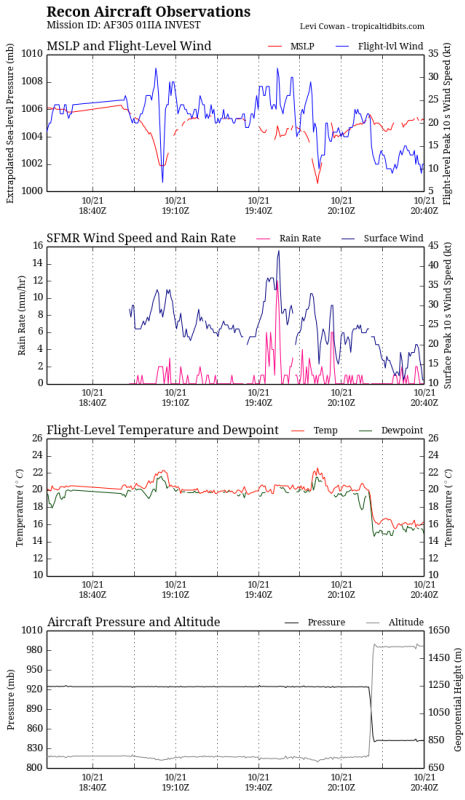
No upgrade but the pressure continued to go down, lol.
URNT12 KNHC 212032
VORTEX DATA MESSAGE
A. 21/20:01:30Z
B. 19 deg 15 min N
093 deg 37 min W
C. 925 mb 692 m
D. 33 kt
E. 193 deg 9 nm
F. 283 deg 29 kt
G. 193 deg 9 nm
H. EXTRAP 1000 mb
I. 20 C / 768 m
J. 23 C / 767 m
K. NA / NA
L. NA
M. NA
N. 134 / 9
O. 0.02 / 1 nm
P. AF305 01IIA INVEST OB 20
MAX FL WIND 32 KT 152 / 19 NM 19:47:00Z
SLP EXTRAP FROM 925 MB
;
0 likes
-
Dean4Storms
- S2K Supporter
- Posts: 6358
- Age: 63
- Joined: Sun Aug 31, 2003 1:01 pm
- Location: Miramar Bch. FL
-
Dean4Storms
- S2K Supporter
- Posts: 6358
- Age: 63
- Joined: Sun Aug 31, 2003 1:01 pm
- Location: Miramar Bch. FL
There is even plenty of at least TD winds by the SFMR not rain contaminated, even a warm core at its COC but yet not upgraded to a TD, mindboggling.
Last edited by NDG on Tue Oct 21, 2014 3:49 pm, edited 1 time in total.
0 likes
-
emeraldislenc
- Category 2

- Posts: 601
- Joined: Fri Aug 24, 2012 4:49 pm
- Location: Emerald Isle NC
-
emeraldislenc
- Category 2
- Posts: 601
- Joined: Fri Aug 24, 2012 4:49 pm
- Location: Emerald Isle NC

Re: ATL: INVEST 93L - Discussion
Does anyone have an update on the SSD satellite? It has been one big outage since 21:45 UTC yesterday.
0 likes
The following post is NOT an official forecast and should not be used as such. It is just the opinion of the poster and may or may not be backed by sound meteorological data. It is NOT endorsed by any professional institution including storm2k.org For Official Information please refer to the NHC and NWS products.
-
CrazyC83
- Professional-Met

- Posts: 34315
- Joined: Tue Mar 07, 2006 11:57 pm
- Location: Deep South, for the first time!
Re: ATL: INVEST 93L - Discussion
From the NHC glossary:
Tropical Cyclone: A warm-core non-frontal synoptic-scale cyclone, originating over tropical or subtropical waters, with organized deep convection and a closed surface wind circulation about a well-defined center. Once formed, a tropical cyclone is maintained by the extraction of heat energy from the ocean at high temperature and heat export at the low temperatures of the upper troposphere. In this they differ from extratropical cyclones, which derive their energy from horizontal temperature contrasts in the atmosphere (baroclinic effects).
Highlighted the missing part.
0 likes

Re:
psyclone wrote:So much for the theory that the NHC has looser upgrade standards for systems in the open ocean vs near the coast. I like the call. the convection is lacking in organization/tenacity at this point. If it changes I'm sure they'll pull the trigger.
Had the winds been stronger they would've likely upgraded. so the theory (likely) stands.
This has missed it's chance to get upgraded, unless they are flying another plane out tomorrow.
0 likes
The above post is not official and should not be used as such. It is the opinion of the poster and may or may not be backed by sound meteorological data. It is not endorsed by any professional institution or storm2k.org. For official information, please refer to the NHC and NWS products.
Re: Re:
Hammy wrote:psyclone wrote:So much for the theory that the NHC has looser upgrade standards for systems in the open ocean vs near the coast. I like the call. the convection is lacking in organization/tenacity at this point. If it changes I'm sure they'll pull the trigger.
Had the winds been stronger they would've likely upgraded. so the theory (likely) stands.
This has missed it's chance to get upgraded, unless they are flying another plane out tomorrow.
They found strong enough winds to have been upgraded to a TD, like mentioned above I will go with the lack of organized convection near the LLC. If convection becomes more organized and concentrated near the LLC an upgrade could be pulled without the recon's flight, IMO.
0 likes
Who is online
Users browsing this forum: No registered users and 22 guests