WPAC: RAMMASUN - Post-Tropical

Moderator: S2k Moderators

Message
Author
User avatar
mrbagyo
Category 5
Category 5
Posts: 3715
Age: 33
Joined: Thu Apr 12, 2012 9:18 am
Location: 14.13N 120.98E
Contact:

Re: WPAC: RAMMASUN - Typhoon

#321 Postby mrbagyo » Mon Jul 14, 2014 9:01 am

xtyphooncyclonex wrote:As of now, parts of Bicol Region & Eastern Visayas are already reporting rainy weather. I wonder how the weather will fare in the next few hours over the region. BTW, How's the weather in Manila right now?


Right now, It's been sticky and hot, the sky is clear with some isolated clouds, heck .. I can even see the stars and the bright moon. Just your normal Manila evening.
I'll roam the metro once more tomorrow as part of my work. I'm currently in Sta Mesa, Manila - one of the areas submerged by tropical storm Ketsana (Ondoy) in 2009.
0 likes   
The posts in this forum are NOT official forecast and should not be used as such. They are just the opinion of the poster and may or may not be backed by sound meteorological data. They are NOT endorsed by any professional institution or storm2k.org. For official information, please refer to RSMC, NHC and NWS products.

dexterlabio
Category 5
Category 5
Posts: 3468
Joined: Sat Oct 24, 2009 11:50 pm

Re:

#322 Postby dexterlabio » Mon Jul 14, 2014 9:02 am

xtyphooncyclonex wrote:As of now, parts of Bicol Region & Eastern Visayas are already reporting rainy weather. I wonder how the weather will fare in the next few hours over the region. BTW, How's the weather in Manila right now?


Nothing to note. Calm and partly cloudy.


Yeah it looks like rain from the outer bands and enhanced monsoon is already affecting Bicol and the Visayas...
0 likes   
Personal Forecast Disclaimer:
The posts in this forum are NOT official forecast and should not be used as such. They are just the opinion of the poster and may or may not be backed by sound meteorological data. They are NOT endorsed by any professional institution or storm2k.org. For official information, please refer to the NHC and NWS products.

stormstrike
Tropical Storm
Tropical Storm
Posts: 159
Joined: Thu Nov 29, 2012 12:37 am

Re: WPAC: RAMMASUN - Typhoon

#323 Postby stormstrike » Mon Jul 14, 2014 9:05 am

xtyphooncyclonex wrote:As of now, parts of Bicol Region & Eastern Visayas are already reporting rainy weather. I wonder how the weather will fare in the next few hours over the region. BTW, How's the weather in Manila right now?


yeah rainy weather here in Tacloban and a little bit windy..
0 likes   

euro6208

Re: WPAC: RAMMASUN - Typhoon

#324 Postby euro6208 » Mon Jul 14, 2014 9:10 am

Image

Direct hit for Metro Manila and JTWC has landfall over Rapu Rapu Island as a strong Category 2 typhoon, 90 knots...
Last edited by euro6208 on Mon Jul 14, 2014 9:13 am, edited 1 time in total.
0 likes   

User avatar
mrbagyo
Category 5
Category 5
Posts: 3715
Age: 33
Joined: Thu Apr 12, 2012 9:18 am
Location: 14.13N 120.98E
Contact:

Re: WPAC: RAMMASUN - Typhoon

#325 Postby mrbagyo » Mon Jul 14, 2014 9:10 am

stormstrike wrote:
xtyphooncyclonex wrote:As of now, parts of Bicol Region & Eastern Visayas are already reporting rainy weather. I wonder how the weather will fare in the next few hours over the region. BTW, How's the weather in Manila right now?


yeah rainy weather here in Tacloban and a little bit windy..


oooh... you're back stormstrike. nice to see you posting again.
0 likes   
The posts in this forum are NOT official forecast and should not be used as such. They are just the opinion of the poster and may or may not be backed by sound meteorological data. They are NOT endorsed by any professional institution or storm2k.org. For official information, please refer to RSMC, NHC and NWS products.

User avatar
xtyphooncyclonex
Category 5
Category 5
Posts: 3861
Age: 23
Joined: Sat Dec 08, 2012 9:07 am
Location: Cebu City
Contact:

#326 Postby xtyphooncyclonex » Mon Jul 14, 2014 9:16 am

Here in Cebu, it is cloudy and there were some rumbles of thunder earlier today...
0 likes   
REMINDER: My opinions that I, or any other NON Pro-Met in this forum, are unofficial. Please do not take my opinions as an official forecast and warning. I am NOT a meteorologist. Following my forecasts blindly may lead to false alarm, danger and risk if official forecasts from agencies are ignored.

stormstrike
Tropical Storm
Tropical Storm
Posts: 159
Joined: Thu Nov 29, 2012 12:37 am

Re: WPAC: RAMMASUN - Typhoon

#327 Postby stormstrike » Mon Jul 14, 2014 9:20 am

mrbagyo wrote:
stormstrike wrote:
xtyphooncyclonex wrote:As of now, parts of Bicol Region & Eastern Visayas are already reporting rainy weather. I wonder how the weather will fare in the next few hours over the region. BTW, How's the weather in Manila right now?


yeah rainy weather here in Tacloban and a little bit windy..


oooh... you're back stormstrike. nice to see you posting again.


oh yes..i miss posting here :) just stopping by and then gonna be back to observer mode :D no stable net yet tsk
0 likes   

euro6208

Re: WPAC: RAMMASUN - Typhoon

#328 Postby euro6208 » Mon Jul 14, 2014 9:29 am

Rammasun doing some dramatic inner core development. -80C tops trying to connect around an eye. Overall system looks way much better with increased consolidation and improved outflow especially to the north where outflow was restricted...
0 likes   

User avatar
cycloneye
Admin
Admin
Posts: 145296
Age: 68
Joined: Thu Oct 10, 2002 10:54 am
Location: San Juan, Puerto Rico

Re: WPAC: RAMMASUN - Typhoon

#329 Postby cycloneye » Mon Jul 14, 2014 9:32 am

Discussion by JTWC of 15:00z warning.

WDPN32 PGTW 141500
MSGID/GENADMIN/JOINT TYPHOON WRNCEN PEARL HARBOR HI//
SUBJ/PROGNOSTIC REASONING FOR TYPHOON 09W (RAMMASUN) WARNING NR 17//
RMKS/
1. FOR METEOROLOGISTS.
2. 6 HOUR SUMMARY AND ANALYSIS.
TYPHOON (TY) 09W (RAMMASUN), LOCATED APPROXIMATELY 435 NM EAST-
SOUTHEAST OF MANILA, PHILIPPINES, HAS TRACKED WEST-SOUTHWESTWARD
AT 10 KNOTS OVER THE PAST SIX HOURS. ANIMATED ENHANCED INFRARED
SATELLITE IMAGERY (EIR) SHOWS TY 09W HAS SLOWED AND CONTINUED TO
CONSOLIDATE AS CONVECTION HAS FURTHER DEEPENED AND HAS SINCE
DEVELOPED AN IRREGULAR 15NM EYE. A 141044Z SSMIS 91GHZ MICROWAVE
IMAGE ALSO SHOWS INCREASED STRENGTHENING AS THE EYEWALL STRUCTURE
HAS BECOME MORE DEVELOPED AND AS CONVECTIVE BANDING ALONG THE
SOUTHERN SEMI-CIRCLE HAS INCREASED. UPPER LEVEL ANALYSIS REVEALS A
FAVORABLE ENVIRONMENT AS VIGOROUS EQUATORWARD OUTFLOW CONTINUES
WHILE VERTICAL WIND SHEAR (VWS) REMAINS AT LOW (05 TO 10 KNOTS)
LEVELS. THE INITIAL POSITION IS BASED UPON THE IRREGULAR EYE FEATURE
SEEN IN THE EIR LOOP WITH HIGH CONFIDENCE. THE CURRENT INTENSITY HAS
BEEN INCREASED TO 75 KNOTS BASED ON THE INCREASED ORGANIZATION
OBSERVED IN THE AFOREMENTIONED SATELLITE IMAGERY WHILE DVORAK
INTENSITY ESTIMATES FROM PGTW AND RJTD HAVE INCREASED TO 77 KNOTS.
TY 09W REMAINS ON A GENERALLY WESTWARD TRACK DESPITE A WEST-
SOUTHWESTWARD DEFLECTION IN THE PAST 6 HOURS DUE TO A SLIGHT
AMPLIFICATION IN THE SOUTHERN PERIPHERY OF THE SUBTROPICAL RIDGE
(STR) THAT IS ANCHORED TO THE NORTH OF THE SYSTEM.
3. FORECAST REASONING.
A. NO CHANGE TO THE FORECAST PHILOSOPHY SINCE THE PREVIOUS
PROGNOSTIC REASONING MESSAGE.
B. TY 09W IS FORECAST TO CONTINUE WESTWARD FOR THE NEXT 12 HOURS
ALONG THE SOUTHERN PERIPHERY OF THE ENTRENCHED STR. THE FAVORABLE
UPPER LEVEL ENVIRONMENT AND CONDUCIVE SEA SURFACE TEMPERATURES (SST)
WILL ALLOW FOR FURTHER INTENSIFICATION THROUGH THE NEXT 12 HOURS
BEFORE THE SYSTEM BEGINS TO INTERACT WITH LAND AND MAKES LANDFALL
JUST BEFORE TAU 24. AS THE SYSTEM TRACKS OVER LAND, A WEAKENING
TREND IS EXPECTED THROUGH TAU 48 UNTIL THE SYSTEM RE-EMERGES IN THE
SOUTH CHINA SEA. A SLIGHT REORIENTATION IN THE STR IS EXPECTED AFTER
TAU 24 WHICH WILL SLIGHTLY TURN TY 09W TO THE WEST-NORTHWEST. AFTER
TAU 48, THE SYSTEM IS FORECAST TO PROCEED FURTHER INTO THE MORE OPEN
WATERS OF THE SOUTH CHINA SEA WHERE THE INCREASED DISTANCE TO LAND,
FAVORABLE UPPER LEVEL SUPPORT AND WARM WATERS WILL CAUSE TY 09W TO
START RE-INTENSIFYING.
C. IN THE EXTENDED TAUS, THE SYSTEM IS FORECAST TO CONTINUE WEST-
NORTHWESTWARD ACROSS THE SOUTH CHINA SEA TOWARDS NORTHERN HAINAN
ISLAND, MAKING LANDFALL BETWEEN TAU 96 AND 120 ACROSS THE LUICHOW
PENINSULA AND INTO MAINLAND CHINA. WARM SST, DECREASED VWS, AND
INCREASED OUTFLOW IN THE SOUTH CHINA SEA WILL ALLOW FOR FURTHER
INTENSIFICATION, REACHING 95 KNOTS PRIOR TO LANDFALL AND WEAKENING
THEREAFTER DUE TO LAND INTERACTION. MODEL GUIDANCE IS IN GOOD
AGREEMENT WITH SOME SLIGHT DIFFERENCES IN TRACK SPEED BUT IS
OTHERWISE TIGHTLY GROUPED. DUE TO THE OVERALL GOOD AGREEMENT IN THE
MODELS, THERE IS NOW HIGH CONFIDENCE IN THE FORECAST TRACK. HOWEVER,
THERE IS STILL SOME UNCERTAINTY IN THE INTENSITY FORECAST DUE TO THE
EXTENT OF THE WEAKENING ANTICIPATED WITH THE LAND INTERACTION IN THE
MID FORECAST.//
0 likes   
Visit the Caribbean-Central America Weather Thread where you can find at first post web cams,radars
and observations from Caribbean basin members Click Here

euro6208

Re: WPAC: RAMMASUN - Typhoon

#330 Postby euro6208 » Mon Jul 14, 2014 9:35 am

cycloneye wrote:Discussion by JTWC of 15:00z warning.


You beat me to it :D

Basically strengthening as we speak...
0 likes   

User avatar
mrbagyo
Category 5
Category 5
Posts: 3715
Age: 33
Joined: Thu Apr 12, 2012 9:18 am
Location: 14.13N 120.98E
Contact:

Re: WPAC: RAMMASUN - Typhoon

#331 Postby mrbagyo » Mon Jul 14, 2014 9:37 am

you can make an instant loop with this tool :darrow:

SSEC REAL EARTH
0 likes   
The posts in this forum are NOT official forecast and should not be used as such. They are just the opinion of the poster and may or may not be backed by sound meteorological data. They are NOT endorsed by any professional institution or storm2k.org. For official information, please refer to RSMC, NHC and NWS products.

euro6208

Re: WPAC: RAMMASUN - Typhoon

#332 Postby euro6208 » Mon Jul 14, 2014 9:52 am

Metro Manila is very populated, over 11.8 Million people alone, a Modern day catastrophe if one were to be headed to the U.S...Manila alone is the most densely populated city in the world...
0 likes   

dexterlabio
Category 5
Category 5
Posts: 3468
Joined: Sat Oct 24, 2009 11:50 pm

#333 Postby dexterlabio » Mon Jul 14, 2014 9:58 am

Is it just me or is this storm now tracking very slowly? Only good thing about this is that Rammasun was moving at a pretty quick pace, meaning it would hit land and get disrupted before it could turn into something worse. But now any additional time it will spend over water will be taken as opportunity to become an intense system.
0 likes   
Personal Forecast Disclaimer:
The posts in this forum are NOT official forecast and should not be used as such. They are just the opinion of the poster and may or may not be backed by sound meteorological data. They are NOT endorsed by any professional institution or storm2k.org. For official information, please refer to the NHC and NWS products.

euro6208

Re: WPAC: RAMMASUN - Typhoon

#334 Postby euro6208 » Mon Jul 14, 2014 10:08 am

Intense massive band of convection [-80C/Dark Grey] right over Catanduanes Island...
0 likes   

User avatar
mrbagyo
Category 5
Category 5
Posts: 3715
Age: 33
Joined: Thu Apr 12, 2012 9:18 am
Location: 14.13N 120.98E
Contact:

Re: WPAC: RAMMASUN - Typhoon

#335 Postby mrbagyo » Mon Jul 14, 2014 10:16 am

0 likes   
The posts in this forum are NOT official forecast and should not be used as such. They are just the opinion of the poster and may or may not be backed by sound meteorological data. They are NOT endorsed by any professional institution or storm2k.org. For official information, please refer to RSMC, NHC and NWS products.

User avatar
wxman57
Moderator-Pro Met
Moderator-Pro Met
Posts: 22978
Age: 67
Joined: Sat Jun 21, 2003 8:06 pm
Location: Houston, TX (southwest)

Re: WPAC: RAMMASUN - Typhoon

#336 Postby wxman57 » Mon Jul 14, 2014 12:49 pm

Nice color shot tweeted by NOAA:
Image
0 likes   

User avatar
cycloneye
Admin
Admin
Posts: 145296
Age: 68
Joined: Thu Oct 10, 2002 10:54 am
Location: San Juan, Puerto Rico

Re: WPAC: RAMMASUN - Typhoon

#337 Postby cycloneye » Mon Jul 14, 2014 1:49 pm

18z Best Track up to 80kts.

09W RAMMASUN 140714 1800 12.7N 126.9E WPAC 80 963
0 likes   
Visit the Caribbean-Central America Weather Thread where you can find at first post web cams,radars
and observations from Caribbean basin members Click Here

User avatar
cycloneye
Admin
Admin
Posts: 145296
Age: 68
Joined: Thu Oct 10, 2002 10:54 am
Location: San Juan, Puerto Rico

Re: WPAC: RAMMASUN - Typhoon

#338 Postby cycloneye » Mon Jul 14, 2014 1:55 pm

JMA 18:40 UTC warning.

TY 1409 (RAMMASUN)
Issued at 18:40 UTC, 14 July 2014
<Analyses at 14/18 UTC>
Scale -
Intensity Strong
Center position N12°35'(12.6°)
E127°05'(127.1°)
Direction and speed of movement W 20km/h(11kt)
Central pressure 975hPa
Maximum wind speed near the center 35m/s(65kt)
Maximum wind gust speed 50m/s(95kt)
Area of 50kt winds or more ALL90km(50NM)
Area of 30kt winds or more ALL260km(140NM)

<Forecast for 15/06 UTC>
Intensity Strong
Center position of probability circle N13°00'(13.0°)
E125°00'(125.0°)
Direction and speed of movement W 20km/h(10kt)
Central pressure 970hPa
Maximum wind speed near the center 35m/s(70kt)
Maximum wind gust speed 50m/s(100kt)
Radius of probability circle 90km(50NM)
Storm warning area ALL190km(100NM)

<Forecast for 15/18 UTC>
Intensity Strong
Center position of probability circle N13°40'(13.7°)
E123°05'(123.1°)
Direction and speed of movement WNW 20km/h(11kt)
Central pressure 970hPa
Maximum wind speed near the center 35m/s(70kt)
Maximum wind gust speed 50m/s(100kt)
Radius of probability circle 140km(75NM)
Storm warning area ALL220km(120NM)

<Forecast for 16/18 UTC>
Intensity -
Center position of probability circle N16°20'(16.3°)
E119°20'(119.3°)
Direction and speed of movement NW 20km/h(11kt)
Central pressure 975hPa
Maximum wind speed near the center 30m/s(60kt)
Maximum wind gust speed 45m/s(85kt)
Radius of probability circle 260km(140NM)
Storm warning area ALL330km(180NM)

<Forecast for 17/18 UTC>
Intensity -
Center position of probability circle N18°20'(18.3°)
E114°30'(114.5°)
Direction and speed of movement WNW 25km/h(13kt)
Central pressure 975hPa
Maximum wind speed near the center 30m/s(60kt)
Maximum wind gust speed 45m/s(85kt)
Radius of probability circle 390km(210NM)
Storm warning area ALL460km(250NM)
0 likes   
Visit the Caribbean-Central America Weather Thread where you can find at first post web cams,radars
and observations from Caribbean basin members Click Here

User avatar
cycloneye
Admin
Admin
Posts: 145296
Age: 68
Joined: Thu Oct 10, 2002 10:54 am
Location: San Juan, Puerto Rico

Re: WPAC: RAMMASUN - Typhoon

#339 Postby cycloneye » Mon Jul 14, 2014 2:41 pm

JTWC 21:00 UTC warning.

Image
0 likes   
Visit the Caribbean-Central America Weather Thread where you can find at first post web cams,radars
and observations from Caribbean basin members Click Here

User avatar
cycloneye
Admin
Admin
Posts: 145296
Age: 68
Joined: Thu Oct 10, 2002 10:54 am
Location: San Juan, Puerto Rico

Re: WPAC: RAMMASUN - Typhoon

#340 Postby cycloneye » Mon Jul 14, 2014 3:10 pm

Discussion of 21:00 UTC warning.

WDPN32 PGTW 142100
MSGID/GENADMIN/JOINT TYPHOON WRNCEN PEARL HARBOR HI//
SUBJ/PROGNOSTIC REASONING FOR TYPHOON 09W (RAMMASUN) WARNING NR 18//
RMKS/
1. FOR METEOROLOGISTS.
2. 6 HOUR SUMMARY AND ANALYSIS.
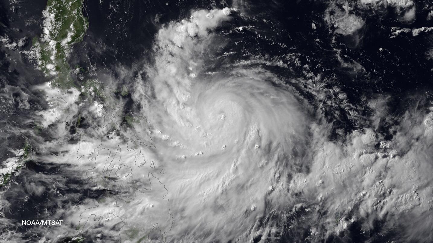
TYPHOON (TY) 09W (RAMMASUN), LOCATED APPROXIMATELY 362 NM
EAST-SOUTHEAST OF MANILA, PHILIPPINES, HAS TRACKED WESTWARD AT 13
KNOTS OVER THE PAST SIX HOURS. ANIMATED ENHANCED INFRARED SATELLITE
IMAGERY (EIR) SHOWS TY 09W HAS, FOR THE MOST PART, MAINTAINED ITS
DEGREE OF WRAP AND CONVECTIVE PATTERN WITH A SLIGHT DEEPENING IN THE
CENTRAL CONVECTION EVEN AS THE EYE HAS BECOME CLOUD-FILLED. THE
INITIAL POSITION IS BASED ON THE EIR ANIMATION WITH FAIR CONFIDENCE.
THE INITIAL INTENSITY IS BASED ON CONGRUENT DVORAK ESTIMATES FROM
PGTW AND RJTD. UPPER LEVEL ANALYSIS REVEALS A FAVORABLE ENVIRONMENT
AS VIGOROUS EQUATORWARD AND WESTWARD OUTFLOW CONTINUE WHILE VERTICAL
WIND SHEAR ARE AT LOW (05 TO 10 KNOT) LEVELS. TY 09W REMAINS ON A
GENERALLY WESTWARD TRACK ALONG THE SOUTHERN PERIPHERY OF A
DEEP-LAYERED SUBTROPICAL RIDGE (STR) TO THE NORTH.
3. FORECAST REASONING.
A. NO CHANGE TO THE FORECAST PHILOSOPHY SINCE THE PREVIOUS
PROGNOSTIC REASONING MESSAGE.
B. TY 09W IS FORECAST TO TRACK ON A MORE WEST-NORTHWESTWARD
TRAJECTORY AS A TRANSITORY MID-LATITUDE TROUGH WEAKENS THE STEERING
STR. IT IS EXPECTED TO MAKE LANDFALL JUST NORTH OF SORSOGON,
PHILIPPINES, SHORTLY AFTER TAU 12. THE FAVORABLE UPPER LEVEL
ENVIRONMENT AND CONDUCIVE SEA SURFACE TEMPERATURES (SST) WILL ALLOW
FOR FURTHER INTENSIFICATION THROUGH THE NEXT 12 HOURS BEFORE THE
SYSTEM BEGINS TO INTERACT WITH LAND. AFTERWARDS, AS THE SYSTEM DRAGS
ACROSS SOUTHERN LUZON AND INTO MANILA, IT WILL WEAKEN DUE TO
FRICTIONAL EFFECTS BUT WILL RE-EMERGE IN THE SOUTH CHINA SEA JUST
NORTH OF SUBIC BAY SHORTLY AFTER TAU 36 AS A STRONG TROPICAL STORM.
WARM SST IN THE SOUTH CHINA SEA PLUS CONTINUED FAVORABLE UPPER LEVEL
CONDITIONS WILL FAVOR RAPID RE-INTENSIFICATION, PEAKING AT 90 KNOTS
BY TAU 72.
C. IN THE EXTENDED TAUS, TYPHOON RAMMASUN IS FORECAST TO CONTINUE
NORTHWESTWARD ACROSS THE SOUTH CHINA SEA MAKING A SECONDARY LANDFALL
OVER NORTHERN HAINAN BEFORE TAU 96. IT WILL THEN CROSS THE GULF OF
TONKIN AND MAKE A FINAL LANDFALL OVER NORTHERN VIETNAM NEAR HANOI.
LAND INTERACTION WILL PRIMARILY CAUSE ITS WEAKENING; HOWEVER,
RAMMASUN WILL MAINTAIN A SOLID 85-KNOT TYPHOON INTENSITY BEFORE ITS
FINAL LANDFALL. DUE TO THE OVERALL GOOD AGREEMENT IN THE MODELS,
THERE IS HIGH CONFIDENCE IN THE FORECAST TRACK. HOWEVER, THERE IS
STILL SOME UNCERTAINTY IN THE EXTENDED INTENSITY FORECAST DUE TO THE
EXTENT OF THE WEAKENING ANTICIPATED WITH THE LAND INTERACTION IN THE
MID FORECAST.//
NNNN
0 likes   
Visit the Caribbean-Central America Weather Thread where you can find at first post web cams,radars
and observations from Caribbean basin members Click Here


Return to “2014”

Who is online

Users browsing this forum: No registered users and 3 guests