ATL: GONZALO - Post-Tropical - Discussion
Moderator: S2k Moderators
-
hurricaneCW
- Category 5

- Posts: 1799
- Joined: Wed Mar 03, 2010 6:20 am
- Location: Toms River, NJ
Re: ATL: GONZALO - Hurricane - Discussion
I wonder if this could at least maintain intensity once EWRC is complete. I see the shear coming so I know timing is everything.
0 likes


-
floridasun78
- Category 5
- Posts: 3755
- Joined: Sun May 17, 2009 10:16 pm
- Location: miami fl
Re:
StarmanHDB wrote:Question....
From my 9th floor perch on Federal Highway in Fort Lauderdale overlooking the ocean I am currently seeing a beautiful pinkish / reddish hue encompassing the entire eastern sky. I know Gonzalo is a pretty good distance out there (pretty much directly east of here), but is this amazing coloring the result of the western sunset reflecting off high altitude ice particles blown out from the storm's outflow? By the way, today's sky has been crystal clear blue the entire day and South Florida's relentless humidity has been suddenly tolerable.
Thanks!
that cloud from front pass by
0 likes
-
cycloneye

- Admin

- Posts: 149514
- Age: 69
- Joined: Thu Oct 10, 2002 10:54 am
- Location: San Juan, Puerto Rico
Re: ATL: GONZALO - Hurricane - Discussion
SUMMARY OF 800 PM AST...0000 UTC...INFORMATION
----------------------------------------------
LOCATION...27.4N 67.8W
ABOUT 385 MI...615 KM SSW OF BERMUDA
MAXIMUM SUSTAINED WINDS...145 MPH...230 KM/H
PRESENT MOVEMENT...NNE OR 20 DEGREES AT 9 MPH...15 KM/H
MINIMUM CENTRAL PRESSURE...943 MB...27.85 INCHES
----------------------------------------------
LOCATION...27.4N 67.8W
ABOUT 385 MI...615 KM SSW OF BERMUDA
MAXIMUM SUSTAINED WINDS...145 MPH...230 KM/H
PRESENT MOVEMENT...NNE OR 20 DEGREES AT 9 MPH...15 KM/H
MINIMUM CENTRAL PRESSURE...943 MB...27.85 INCHES
0 likes
Visit the Caribbean-Central America Weather Thread where you can find at first post web cams,radars
and observations from Caribbean basin members Click Here
and observations from Caribbean basin members Click Here

Re: ATL: GONZALO - Hurricane - Discussion
Still 145 mph! That was not expected.cycloneye wrote:SUMMARY OF 800 PM AST...0000 UTC...INFORMATION
----------------------------------------------
LOCATION...27.4N 67.8W
ABOUT 385 MI...615 KM SSW OF BERMUDA
MAXIMUM SUSTAINED WINDS...145 MPH...230 KM/H
PRESENT MOVEMENT...NNE OR 20 DEGREES AT 9 MPH...15 KM/H
MINIMUM CENTRAL PRESSURE...943 MB...27.85 INCHES
Pressure's up by 1 MB though
0 likes
-
cycloneye
- Admin
- Posts: 149514
- Age: 69
- Joined: Thu Oct 10, 2002 10:54 am
- Location: San Juan, Puerto Rico
Re: ATL: GONZALO - Hurricane - Discussion
Let's see how strong the NE quadrant is as plane makes shortly NE to SW pass.
0 likes
Visit the Caribbean-Central America Weather Thread where you can find at first post web cams,radars
and observations from Caribbean basin members Click Here
and observations from Caribbean basin members Click Here
-
EquusStorm
- Category 5
- Posts: 1649
- Age: 35
- Joined: Thu Nov 07, 2013 1:04 pm
- Location: Jasper, AL
- Contact:
That's... not good at all. At this point I wonder if it will have time to drop much below category four intensity before closest approach... might well give Fabian a run for his money.
0 likes
Colors of lost purpose on the canvas of irrelevance
Not a meteorologist, in fact more of an idiot than anything. You should probably check with the NHC or a local NWS office for official information.
Not a meteorologist, in fact more of an idiot than anything. You should probably check with the NHC or a local NWS office for official information.
-
TheStormExpert
Re:
EquusStorm wrote:That's... not good at all. At this point I wonder if it will have time to drop much below category four intensity before closest approach... might well give Fabian a run for his money.
Could very well be stronger than Fabian!
Hope Bermuda is well prepared at this point and preparations are done.
0 likes
-
cycloneye
- Admin
- Posts: 149514
- Age: 69
- Joined: Thu Oct 10, 2002 10:54 am
- Location: San Juan, Puerto Rico
Re: ATL: GONZALO - Hurricane - Discussion
All is good now so in this important moment for Bermuda,the discussions are not derailed by clowns or trolls so let's return to the civil discussions.
0 likes
Visit the Caribbean-Central America Weather Thread where you can find at first post web cams,radars
and observations from Caribbean basin members Click Here
and observations from Caribbean basin members Click Here

-
EquusStorm
- Category 5
- Posts: 1649
- Age: 35
- Joined: Thu Nov 07, 2013 1:04 pm
- Location: Jasper, AL
- Contact:
Re: Re:
TheStormExpert wrote:EquusStorm wrote:That's... not good at all. At this point I wonder if it will have time to drop much below category four intensity before closest approach... might well give Fabian a run for his money.
Could very well be stronger than Fabian!
Hope Bermuda is well prepared at this point and preparations are done.
It will have to drop all the way to below 105kt in less than a day to be weaker than Fabian, and frankly given its solid organization and decent conditions currently, I think it won't drop that far in time. Probably gonna set some records... very bad situation for Bermuda. Also that CIMSS shot... WOW. Bigger is NOT better in this case. Will also increase surge height.
Last edited by EquusStorm on Thu Oct 16, 2014 7:36 pm, edited 1 time in total.
0 likes
Colors of lost purpose on the canvas of irrelevance
Not a meteorologist, in fact more of an idiot than anything. You should probably check with the NHC or a local NWS office for official information.
Not a meteorologist, in fact more of an idiot than anything. You should probably check with the NHC or a local NWS office for official information.

-
supercane4867
- Category 5
- Posts: 4966
- Joined: Wed Nov 14, 2012 10:43 am
Re: ATL: GONZALO - Hurricane - Discussion
A larger eye is quite helpful in terms of maintaining intensity in high latitudes. Gonzalo should weaken only slowly at most as it approaches Bermuda
0 likes
-
cycloneye
- Admin
- Posts: 149514
- Age: 69
- Joined: Thu Oct 10, 2002 10:54 am
- Location: San Juan, Puerto Rico
Re: ATL: GONZALO - Hurricane - Discussion
00z Best Track is slightly down to 120kts.
AL, 08, 2014101700, , BEST, 0, 274N, 678W, 120, 943, HU
AL, 08, 2014101700, , BEST, 0, 274N, 678W, 120, 943, HU
0 likes
Visit the Caribbean-Central America Weather Thread where you can find at first post web cams,radars
and observations from Caribbean basin members Click Here
and observations from Caribbean basin members Click Here

Hurricane Gonzalo as seen form the International Space Station
http://www.accuweather.com/en/weather-v ... 2788328001
http://www.accuweather.com/en/weather-v ... 2788328001
0 likes
Too many hurricanes to remember
-
tropicwatch

- Category 5
- Posts: 3426
- Age: 62
- Joined: Sat Jun 02, 2007 10:01 am
- Location: The Villages, Florida
- Contact:
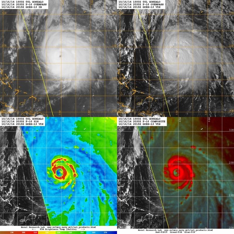
During the pass where they found such high winds look at the cloud tops in that area.

0 likes
Tropicwatch
Agnes 72', Eloise 75, Elena 85', Kate 85', Charley 86', Florence 88', Beryl 94', Dean 95', Erin 95', Opal 95', Earl 98', Georges 98', Ivan 2004', Arlene 2005', Dennis 2005', Ida 2009' Debby 2012' Irma 2017' Michael 2018'
Agnes 72', Eloise 75, Elena 85', Kate 85', Charley 86', Florence 88', Beryl 94', Dean 95', Erin 95', Opal 95', Earl 98', Georges 98', Ivan 2004', Arlene 2005', Dennis 2005', Ida 2009' Debby 2012' Irma 2017' Michael 2018'
-
ftolmsteen

- Tropical Storm

- Posts: 122
- Joined: Mon Jun 25, 2007 6:34 am
- Location: Port Richey, FL
Who is online
Users browsing this forum: No registered users and 28 guests