ATL: DORIAN - Post-Tropical - Discussion

Moderator: S2k Moderators

Message
Author
User avatar
TropicalAnalystwx13
Category 5
Category 5
Posts: 2109
Age: 27
Joined: Tue Jul 19, 2011 8:20 pm
Location: Wilmington, NC
Contact:

Re:

#101 Postby TropicalAnalystwx13 » Mon Jul 22, 2013 7:57 pm

meriland23 wrote:What will be working against the system later in the week, and is it less favorable than Chantal had?

Depends on how it tracks. If it follows the southern end of the model guidance, just a brief dip into sub-26C waters. If it follows the northern end, a prolonged track across waters too cool for intensification, a more stable environment, faster trade winds, and eventually wind shear.
0 likes   

User avatar
NDG
S2K Supporter
S2K Supporter
Posts: 15420
Joined: Sun Jul 09, 2006 10:14 pm
Location: Orlando, FL

Re: ATL: INVEST 98L - Discussion

#102 Postby NDG » Mon Jul 22, 2013 7:58 pm

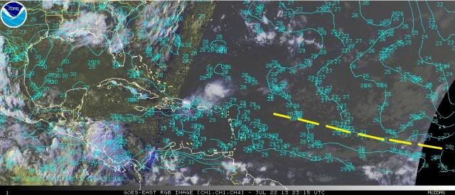
ozonepete wrote:I don't get where there'll be any problem with SSTs. Given the rough track this is going on, and consensus is pretty tightly clustered, this will never go over water lower than 27C. I drew in the roughly expected path for the next few days over an RGB sat image with current SSTs.

Image


Your track is a bit too far south.
It will be tracking over some sub 26 deg C water after 24-36 hrs, if the GFS is correct.

Image
0 likes   

ozonepete
Professional-Met
Professional-Met
Posts: 4743
Joined: Mon Sep 07, 2009 3:23 pm
Location: From Ozone Park, NYC / Now in Brooklyn, NY

Re: ATL: INVEST 98L - Discussion

#103 Postby ozonepete » Mon Jul 22, 2013 8:25 pm

:uarrow: Even on the track you posted it would spend a day at most over marginal SSTs (darker green). The lighter green area, if that panned out, is more than enough for a TS to maintain. It just doesn't seem to be a significant factor.
0 likes   

User avatar
cycloneye
Admin
Admin
Posts: 142552
Age: 68
Joined: Thu Oct 10, 2002 10:54 am
Location: San Juan, Puerto Rico

Re: ATL: INVEST 98L - Discussion

#104 Postby cycloneye » Mon Jul 22, 2013 8:36 pm

It may be moving a little bit south of due west at this time. Will be interesting to see if that is a temporary jog or more than that.
0 likes   
Visit the Caribbean-Central America Weather Thread where you can find at first post web cams,radars
and observations from Caribbean basin members Click Here

Alyono
Professional-Met
Professional-Met
Posts: 6961
Joined: Fri Apr 26, 2013 3:52 pm
Location: Texas Coast

Re: ATL: INVEST 98L - Discussion

#105 Postby Alyono » Mon Jul 22, 2013 8:37 pm

cycloneye wrote:They are the experts that know all of what is going on with the system with the many tools they have and decided that it didn't warranted more than 30% at this time.


Each forecaster has a different opinion as to whether or not this will develop. I usually am not surprised who at NHC makes the forecast, just based upon the probabilities given

As for the percentage, I for one think that the best chance to develop may not occur until about 5-7 days, once it moves past the shear. I am only giving this a 20 percent chance of development through 48 hours
0 likes   

RL3AO
Moderator-Pro Met
Moderator-Pro Met
Posts: 16308
Joined: Thu Jun 14, 2007 10:03 pm
Location: NC

#106 Postby RL3AO » Mon Jul 22, 2013 8:42 pm

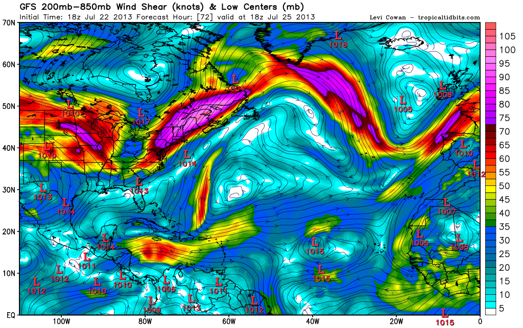
Image

Lots of strong westerly winds north of the low likely shearing it. Also note a TUTT forming south of Bermuda which won't make life easy later on.
0 likes   

User avatar
NDG
S2K Supporter
S2K Supporter
Posts: 15420
Joined: Sun Jul 09, 2006 10:14 pm
Location: Orlando, FL

Re: ATL: INVEST 98L - Discussion

#107 Postby NDG » Mon Jul 22, 2013 8:48 pm

ozonepete wrote::uarrow: Even on the track you posted it would spend a day at most over marginal SSTs (darker green). The lighter green area, if that panned out, is more than enough for a TS to maintain. It just doesn't seem to be a significant factor.


Very true, I have seen tropical systems survive 25 deg C waters but as we know a bigger obstacle could be the more stable air further away from the itcz.
0 likes   

ozonepete
Professional-Met
Professional-Met
Posts: 4743
Joined: Mon Sep 07, 2009 3:23 pm
Location: From Ozone Park, NYC / Now in Brooklyn, NY

Re: ATL: INVEST 98L - Discussion

#108 Postby ozonepete » Mon Jul 22, 2013 9:03 pm

NDG wrote:
ozonepete wrote::uarrow: Even on the track you posted it would spend a day at most over marginal SSTs (darker green). The lighter green area, if that panned out, is more than enough for a TS to maintain. It just doesn't seem to be a significant factor.


Very true, I have seen tropical systems survive 25 deg C waters but as we know a bigger obstacle could be the more stable air further away from the itcz.


Yeah, mainly the dreaded dust. Right now you can see the SAL dust cluster is west and north of it but moving ahead of it at the same forward speed as this disturbance. If this system maintains its current speed or slows down at all it may never ingest much of it, similar to what happened with Chantal. Mid-level moisture is good right now (pretty obvious with all of that convection) but that can change as well. I would really want to wait for tonight's 00Z runs but especially tomorrow morning's runs to see what the models do with it (and its future environment) after they initialize it better.
0 likes   

User avatar
SFLcane
S2K Supporter
S2K Supporter
Posts: 10104
Age: 47
Joined: Sat Jun 05, 2010 1:44 pm
Location: Lake Worth Florida

Re: ATL: INVEST 98L - Discussion

#109 Postby SFLcane » Mon Jul 22, 2013 9:06 pm

Plenty of trofs in line ready to weaken what ever ridge there is of the southeast.
0 likes   

User avatar
meriland23
Category 5
Category 5
Posts: 1239
Age: 36
Joined: Mon Aug 29, 2011 9:29 pm

Re: ATL: INVEST 98L - Discussion

#110 Postby meriland23 » Mon Jul 22, 2013 9:09 pm

I know how reliable GFS/EURO is with the general track and intensity of disturbances, but how reliable are they at forecasting dry air/ shear/ etc this far out?
0 likes   
The posts in this forum are NOT official forecast and should not be used as such. They are just the opinion of the poster and may or may not be backed by sound meteorological data. They are NOT endorsed by any professional institution or storm2k.org. For official information, please refer to the NHC and NWS products.

ozonepete
Professional-Met
Professional-Met
Posts: 4743
Joined: Mon Sep 07, 2009 3:23 pm
Location: From Ozone Park, NYC / Now in Brooklyn, NY

Re: ATL: INVEST 98L - Discussion

#111 Postby ozonepete » Mon Jul 22, 2013 9:15 pm

meriland23 wrote:I know how reliable GFS/EURO is with the general track and intensity of disturbances, but how reliable are they at forecasting dry air/ shear/ etc this far out?


They're pretty good with dry air but the models often get shear really wrong more than a day or two out. There's just not enough upper air observations out over the Atlantic so the models don't have good input to make a better forecast. I always look to see how shear will be even 1-5 days out but I just don't trust it very much past the second day. It's often way over-estimated or under-estimated.
0 likes   

RL3AO
Moderator-Pro Met
Moderator-Pro Met
Posts: 16308
Joined: Thu Jun 14, 2007 10:03 pm
Location: NC

#112 Postby RL3AO » Mon Jul 22, 2013 9:16 pm

When you look at TPW loop, I notice two things.

1) Its got a very noticeable spin, especially for a system that has just left Africa.
2) The dry air seems to be moving faster, or at least the same speed as the wave.

http://tropic.ssec.wisc.edu/real-time/m ... /main.html
0 likes   

User avatar
NDG
S2K Supporter
S2K Supporter
Posts: 15420
Joined: Sun Jul 09, 2006 10:14 pm
Location: Orlando, FL

Re: ATL: INVEST 98L - Discussion

#113 Postby NDG » Mon Jul 22, 2013 9:17 pm

meriland23 wrote:I know how reliable GFS/EURO is with the general track and intensity of disturbances, but how reliable are they at forecasting dry air/ shear/ etc this far out?


IMO, they handle moisture content better in the atmosphere but shear is not handled very well. I lately like to stay in the 48-72 hr range when it comes to shear.
0 likes   

floridasun78
Category 5
Category 5
Posts: 3755
Joined: Sun May 17, 2009 10:16 pm
Location: miami fl

Re: ATL: INVEST 98L - Models

#114 Postby floridasun78 » Mon Jul 22, 2013 9:17 pm

:uarrow: :uarrow: that look like nhc think going out to sea
0 likes   

User avatar
meriland23
Category 5
Category 5
Posts: 1239
Age: 36
Joined: Mon Aug 29, 2011 9:29 pm

Re:

#115 Postby meriland23 » Mon Jul 22, 2013 9:18 pm

RL3AO wrote:When you look at TPW loop, I notice two things.

1) Its got a very noticeable spin, especially for a system that has just left Africa.
2) The dry air seems to be moving faster, or at least the same speed as the wave.

http://tropic.ssec.wisc.edu/real-time/m ... /main.html


I know, it is like Africa gave birth to a tropical storm almost, not a wave.. it is just kicking it up a few notches quite rapidly..
0 likes   
The posts in this forum are NOT official forecast and should not be used as such. They are just the opinion of the poster and may or may not be backed by sound meteorological data. They are NOT endorsed by any professional institution or storm2k.org. For official information, please refer to the NHC and NWS products.

User avatar
meriland23
Category 5
Category 5
Posts: 1239
Age: 36
Joined: Mon Aug 29, 2011 9:29 pm

Re: ATL: INVEST 98L - Discussion

#116 Postby meriland23 » Mon Jul 22, 2013 9:20 pm

NDG wrote:
meriland23 wrote:I know how reliable GFS/EURO is with the general track and intensity of disturbances, but how reliable are they at forecasting dry air/ shear/ etc this far out?


IMO, they handle moisture content better in the atmosphere but shear is not handled very well. I lately like to stay in the 48-72 hr range when it comes to shear.


So what is working against this storm in the long run? And are these pretty definite circumstances ?
0 likes   
The posts in this forum are NOT official forecast and should not be used as such. They are just the opinion of the poster and may or may not be backed by sound meteorological data. They are NOT endorsed by any professional institution or storm2k.org. For official information, please refer to the NHC and NWS products.

RL3AO
Moderator-Pro Met
Moderator-Pro Met
Posts: 16308
Joined: Thu Jun 14, 2007 10:03 pm
Location: NC

#117 Postby RL3AO » Mon Jul 22, 2013 9:22 pm

Wind shear, unless I'm totally misreading the models.
0 likes   

Alyono
Professional-Met
Professional-Met
Posts: 6961
Joined: Fri Apr 26, 2013 3:52 pm
Location: Texas Coast

Re:

#118 Postby Alyono » Mon Jul 22, 2013 9:26 pm

RL3AO wrote:When you look at TPW loop, I notice two things.

1) Its got a very noticeable spin, especially for a system that has just left Africa.
2) The dry air seems to be moving faster, or at least the same speed as the wave.

http://tropic.ssec.wisc.edu/real-time/m ... /main.html


watch for dry air from BEHIND the system. The air ahead is seldom the dry air that impacts a system in the tropical Atlantic
0 likes   

User avatar
Blown Away
S2K Supporter
S2K Supporter
Posts: 10119
Joined: Wed May 26, 2004 6:17 am

Re: ATL: INVEST 98L - Models

#119 Postby Blown Away » Mon Jul 22, 2013 9:27 pm

Image
00z models...TVCN goes WNW and ends just NE of Caribbean...Hard to go against the models saying limited development at best
0 likes   
Hurricane Eye Experience: David 79, Irene 99, Frances 04, Jeanne 04, Wilma 05... EYE COMING MY WAY IN 2024…
Hurricane Brush Experience: Andrew 92, Erin 95, Floyd 99, Matthew 16, Irma 17, Ian 22, Nicole 22…

Alyono
Professional-Met
Professional-Met
Posts: 6961
Joined: Fri Apr 26, 2013 3:52 pm
Location: Texas Coast

Re: ATL: INVEST 98L - Discussion

#120 Postby Alyono » Mon Jul 22, 2013 9:27 pm

NDG wrote:
meriland23 wrote:I know how reliable GFS/EURO is with the general track and intensity of disturbances, but how reliable are they at forecasting dry air/ shear/ etc this far out?


IMO, they handle moisture content better in the atmosphere but shear is not handled very well. I lately like to stay in the 48-72 hr range when it comes to shear.


models are notoriously HORRIBLE for predicting dry air in the tropics. Have not looked in recent years, but before, RH values tended to have a high bias
0 likes   


Return to “2013”

Who is online

Users browsing this forum: No registered users and 3 guests