ATL: INGRID - Remnants - Discussion

Moderator: S2k Moderators

Message
Author
jeff
Professional-Met
Professional-Met
Posts: 831
Joined: Sun Sep 12, 2004 6:14 pm
Location: Houston, TX
Contact:

Re: ATL: INVEST 93L - Discussion - 20% - 70%

#101 Postby jeff » Tue Sep 10, 2013 8:34 pm

Houstonia wrote:Any idea what the tides will be like in Galveston this weekend? I've got family visiting - they are driving back north on Monday. We plan to go to Galveston on Sunday - it would be nice to take them on the ferry and have it be a bit of a thrill ride for them. :)


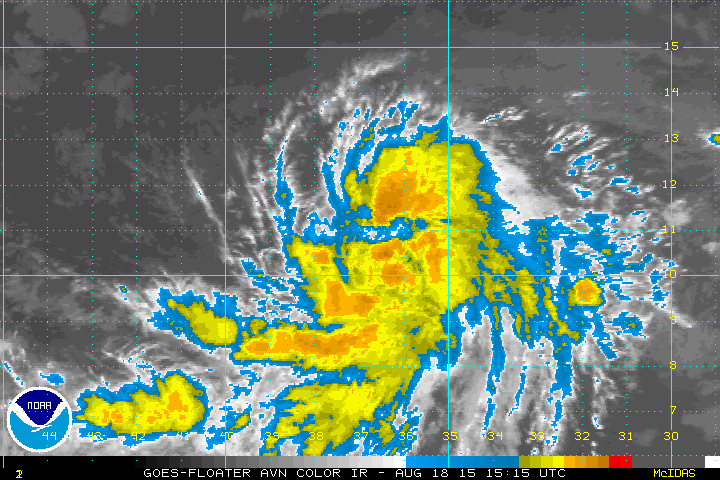
Looking at total water level rises of around 1.5-2.5 feet over the weekend above MSL. Could be closer to 3.5 feet if the system spins up and heads more NW toward S TX. Swells building to near 10 feet by Sunday with significant rip current issues
0 likes   

User avatar
cycloneye
Admin
Admin
Posts: 139604
Age: 67
Joined: Thu Oct 10, 2002 10:54 am
Location: San Juan, Puerto Rico

Re: ATL: INVEST 93L - Models

#102 Postby cycloneye » Tue Sep 10, 2013 8:36 pm

stormlover2013 wrote:@TropicalTidbits: @JimCantore Watch the western US/Canada ridge flip to trough. Texas ridge dies and shifts eastward. 6-10 z500 anomaly http://t.co/f36AJKzhsH

@TropicalTidbits: @JimCantore If there is a TC in position to come north, yes. 93L may do just that if it doesn't form too quickly.

@TropicalTidbits: @JimCantore -PDO w/ warm NPAC forces trough into the continent as wavelengths get longer in the Fall. This is forcing the TX ridge out.


To let you know that I moved your post from the models thread to this one.
0 likes   
Visit the Caribbean-Central America Weather Thread where you can find at first post web cams,radars
and observations from Caribbean basin members Click Here

User avatar
Ptarmigan
Category 5
Category 5
Posts: 5273
Joined: Wed Aug 16, 2006 9:06 pm

Re: Re:

#103 Postby Ptarmigan » Tue Sep 10, 2013 8:51 pm

ROCK wrote:
1998 Frances was huge extending all the way to LA....came in around CC....seems like a good track. I do think it has potential to make cane status...


Frances could've been a hurricane if it stayed over the Gulf of Mexico longer. It had tropical storm force winds extending up to 345 miles.
0 likes   

User avatar
Ptarmigan
Category 5
Category 5
Posts: 5273
Joined: Wed Aug 16, 2006 9:06 pm

Re: Re:

#104 Postby Ptarmigan » Tue Sep 10, 2013 8:53 pm

jeff wrote:
Frances (98) was moving WNW at landfall out of the central/NW Gulf...she did not come up from the Bay of Campeche. Current GFS track is closest to Hermine only slower and larger. FIM tracks would be a rare NW to NNW to N to NNE track kind of rounding the entire TX coast. That has happened before, but not in the recent past decades.


Frances was a huge rain maker over a large area. It also eroded beaches, the worst erosion since Carla I have read. Parts of Mexico got 44 inches of rain from Frances.

http://www.hpc.ncep.noaa.gov/tropical/r ... s1998.html
0 likes   

jeff
Professional-Met
Professional-Met
Posts: 831
Joined: Sun Sep 12, 2004 6:14 pm
Location: Houston, TX
Contact:

Re: Re:

#105 Postby jeff » Tue Sep 10, 2013 9:02 pm

Ptarmigan wrote:
jeff wrote:
Frances (98) was moving WNW at landfall out of the central/NW Gulf...she did not come up from the Bay of Campeche. Current GFS track is closest to Hermine only slower and larger. FIM tracks would be a rare NW to NNW to N to NNE track kind of rounding the entire TX coast. That has happened before, but not in the recent past decades.


Frances was a huge rain maker over a large area. It also eroded beaches, the worst erosion since Carla I have read. Parts of Mexico got 44 inches of rain from Frances.

http://www.hpc.ncep.noaa.gov/tropical/r ... s1998.html


NHC and HPC tracks not matching very well there. I remember the NHC version of a poorly organized TC in the NW Gulf interacting with a left over frontal boundary. Front acted like a coastal convergence lifting zone which helped spread out heavy rainfall along the US Gulf coast well east of the center. Near landfall the system finally got its act together some...but still it was a lopsided system with much of the impacts on the upper TX and LA coasts.
0 likes   

User avatar
ROCK
Category 5
Category 5
Posts: 9254
Age: 53
Joined: Tue Aug 17, 2004 7:30 am
Location: Kemah, Texas

Re: ATL: INVEST 93L - Discussion - 20% - 70%

#106 Postby ROCK » Tue Sep 10, 2013 9:31 pm

http://tropic.ssec.wisc.edu/real-time/w ... oom=&time=

looks like a building an anticyclone over 93L
0 likes   

User avatar
Portastorm
Storm2k Moderator
Storm2k Moderator
Posts: 9788
Age: 62
Joined: Fri Jul 11, 2003 9:16 am
Location: South Austin, TX
Contact:

Re: ATL: INVEST 93L - Discussion - 20% - 70%

#107 Postby Portastorm » Tue Sep 10, 2013 9:53 pm

Interesting satellite loop tonight as the convection just east of the Yucatan as well as in the SW Gulf/BOC has diminished considerably. I'm not suggesting anything could/should be read into that just ... interesting.
0 likes   
Any forecasts under my name are to be taken with a grain of salt. Get your best forecasts from the National Weather Service and National Hurricane Center.

I'm a certified Advanced SKYWARN-trained spotter and am active on Twitter at @TravisCOSW, a social media partner of the NWS Austin-San Antonio office.

User avatar
ROCK
Category 5
Category 5
Posts: 9254
Age: 53
Joined: Tue Aug 17, 2004 7:30 am
Location: Kemah, Texas

Re: ATL: INVEST 93L - Discussion - 20% - 70%

#108 Postby ROCK » Tue Sep 10, 2013 9:56 pm

Portastorm wrote:Interesting satellite loop tonight as the convection just east of the Yucatan as well as in the SW Gulf/BOC has diminished considerably. I'm not suggesting anything could/should be read into that just ... interesting.


I expected it...D-min....MLCs look good during the afternoon but peter out after sun set...been the story of 2013....you can see the circulation still offshore though. Wait for Dmax and I think we will see something better.....JMO
0 likes   

hurricanehunter69
Category 1
Category 1
Posts: 331
Joined: Sun May 16, 2010 5:21 pm
Location: New Orleans

Re: ATL: INVEST 93L - Discussion - 20% - 70%

#109 Postby hurricanehunter69 » Tue Sep 10, 2013 10:03 pm

Check out the huge ULL out west. This could be a player in what helps nudge 93L more poleward. http://www.ssd.noaa.gov/goes/comp/ceus/flash-wv.html
0 likes   

User avatar
LaBreeze
Category 5
Category 5
Posts: 1497
Joined: Thu Sep 04, 2003 1:57 pm
Location: SW Louisiana

Re: ATL: INVEST 93L - Discussion - 20% - 70%

#110 Postby LaBreeze » Tue Sep 10, 2013 10:06 pm

Will proximity to land (Mexico/Texas) inhibit much development from the looks of some of the models? Just wondering about strength (should this system develop).
0 likes   
Audrey (1957), Carla (1961), Hilda (1964), Betsy (1965), Edith (1971), Carmen (1974), Danny (1985), Juan (1985), Andrew (1992), Lili (2002), Rita (2005), Gustav (2008), Ike (2008), and stuck in the eye of Iniki (1992) while vacationing in Kauai.

Not an official forecast by any means.

User avatar
tropicwatch
Category 5
Category 5
Posts: 3205
Age: 60
Joined: Sat Jun 02, 2007 10:01 am
Location: Panama City Florida
Contact:

#111 Postby tropicwatch » Tue Sep 10, 2013 10:10 pm

Some serious convection building north of Honduras tonight. This is becoming very interesting, does not appear to be much movement any direction at this time.
0 likes   
Tropicwatch


Agnes 72', Eloise 75, Elena 85', Kate 85', Charley 86', Florence 88', Beryl 94', Dean 95', Erin 95', Opal 95', Earl 98', Georges 98', Ivan 2004', Arlene 2005', Dennis 2005', Ida 2009' Debby 2012' Irma 2017' Michael 2018'

User avatar
HURAKAN
Professional-Met
Professional-Met
Posts: 46086
Age: 37
Joined: Thu May 20, 2004 4:34 pm
Location: Key West, FL
Contact:

#112 Postby HURAKAN » Tue Sep 10, 2013 10:22 pm

Image

not much yet at 850 mb
0 likes   

User avatar
tropicwatch
Category 5
Category 5
Posts: 3205
Age: 60
Joined: Sat Jun 02, 2007 10:01 am
Location: Panama City Florida
Contact:

Re:

#113 Postby tropicwatch » Tue Sep 10, 2013 10:28 pm

HURAKAN wrote:[
not much yet at 850 mb


True but the convection is impressive.

Image

http://tropicwatch.info
0 likes   

User avatar
ROCK
Category 5
Category 5
Posts: 9254
Age: 53
Joined: Tue Aug 17, 2004 7:30 am
Location: Kemah, Texas

Re: ATL: INVEST 93L - Discussion - 20% - 70%

#114 Postby ROCK » Tue Sep 10, 2013 10:30 pm

very large rotation....WPAC systems come to mind in their development stages....
0 likes   

User avatar
ROCK
Category 5
Category 5
Posts: 9254
Age: 53
Joined: Tue Aug 17, 2004 7:30 am
Location: Kemah, Texas

Re: ATL: INVEST 93L - Discussion - 20% - 70%

#115 Postby ROCK » Tue Sep 10, 2013 10:34 pm

LaBreeze wrote:Will proximity to land (Mexico/Texas) inhibit much development from the looks of some of the models? Just wondering about strength (should this system develop).


BOC has really ramped up storms this year....even the NAM has a 996mb low down there in a few days...NAVGEM had a 997mb a few runs ago.....very large system will need time to consolidate but as far a heat potential thats not going to be an issue...


Image

Uploaded with ImageShack.us
0 likes   

CrazyC83
Professional-Met
Professional-Met
Posts: 33399
Joined: Tue Mar 07, 2006 11:57 pm
Location: Deep South, for the first time!

#116 Postby CrazyC83 » Tue Sep 10, 2013 10:40 pm

The loop current is well to the west of normal on there, so if it tracks farther east, it could get ugly in a hurry.
0 likes   

User avatar
AJC3
Admin
Admin
Posts: 3887
Age: 60
Joined: Tue Aug 31, 2004 7:04 pm
Location: West Melbourne, Florida
Contact:

Re:

#117 Postby AJC3 » Tue Sep 10, 2013 11:08 pm

CrazyC83 wrote:The loop current is well to the west of normal on there, so if it tracks farther east, it could get ugly in a hurry.


That's not the loop current that you're looking at, but it may be a warm ring (eddy) that separated from it. Would need a time lapse of SST analyses to say for sure. In any event, it is an area of anomalously warm water, so your point still stands.
0 likes   

User avatar
LaBreeze
Category 5
Category 5
Posts: 1497
Joined: Thu Sep 04, 2003 1:57 pm
Location: SW Louisiana

Re:

#118 Postby LaBreeze » Tue Sep 10, 2013 11:27 pm

CrazyC83 wrote:The loop current is well to the west of normal on there, so if it tracks farther east, it could get ugly in a hurry.


Ugly, how?
0 likes   
Audrey (1957), Carla (1961), Hilda (1964), Betsy (1965), Edith (1971), Carmen (1974), Danny (1985), Juan (1985), Andrew (1992), Lili (2002), Rita (2005), Gustav (2008), Ike (2008), and stuck in the eye of Iniki (1992) while vacationing in Kauai.

Not an official forecast by any means.

User avatar
ROCK
Category 5
Category 5
Posts: 9254
Age: 53
Joined: Tue Aug 17, 2004 7:30 am
Location: Kemah, Texas

Re: Re:

#119 Postby ROCK » Tue Sep 10, 2013 11:30 pm

LaBreeze wrote:
CrazyC83 wrote:The loop current is well to the west of normal on there, so if it tracks farther east, it could get ugly in a hurry.


Ugly, how?


he means if conditions aloft are good the potential is there for this to get stronger. see map above....all the dark blue is nitrous oxide for a TC.... :D
0 likes   

User avatar
LaBreeze
Category 5
Category 5
Posts: 1497
Joined: Thu Sep 04, 2003 1:57 pm
Location: SW Louisiana

Re: Re:

#120 Postby LaBreeze » Tue Sep 10, 2013 11:32 pm

ROCK wrote:
LaBreeze wrote:
CrazyC83 wrote:The loop current is well to the west of normal on there, so if it tracks farther east, it could get ugly in a hurry.


Ugly, how?


he means if conditions aloft are good the potential is there for this to get stronger. see map above....all the dark blue is nitrous oxide for a TC.... :D


Thank you ~
0 likes   
Audrey (1957), Carla (1961), Hilda (1964), Betsy (1965), Edith (1971), Carmen (1974), Danny (1985), Juan (1985), Andrew (1992), Lili (2002), Rita (2005), Gustav (2008), Ike (2008), and stuck in the eye of Iniki (1992) while vacationing in Kauai.

Not an official forecast by any means.


Return to “2013”

Who is online

Users browsing this forum: No registered users and 5 guests