Who can post the 12z Gfs?
Sent from my HTC EVO 4G LTE
ATL: DORIAN - Post-Tropical - Discussion
Moderator: S2k Moderators
-
WeatherEmperor
- S2K Supporter

- Posts: 4806
- Age: 42
- Joined: Thu Sep 04, 2003 2:54 pm
- Location: South Florida
Re: ATL: DORIAN - Models
0 likes

-
MiamiensisWx
Re: ATL: DORIAN - Tropical Storm - Discussion
Based upon the current satellite appearance, Dorian is being undermined by the strong easterly trade winds in which it is currently embedded. This is allowing the LLC to outrun the MLC on the most recent satellite images. Thus, due to easterly shear, the center is outrunning the +PVA (convection); and because Dorian is such a small system, the impact on the strength would be strongly negative within the next 36-48 hours. Because Dorian is already so far N and E, climatology for similar systems in July usually indicates that systems in Dorian's location do not survive long due to cooler waters and higher stability N of 15°N and E of 55°W. I would not be surprised if Dorian deteriorates into a mostly-naked swirl in 24 hours, meaning a much faster movement through the next three days. That would place the system over the Leeward Islands in about three days; and if Dorian has lost much of its organization by then, it will struggle to avoid getting entangled in Hispaniola before it has a chance to regenerate. That could mean heavy rainfall or flash flooding for the islands and is in line with the ECMWF and GEM solutions, which at 72 hours are farther south than the model consensus.
0 likes
-
Hurricaneman

- Category 5

- Posts: 7404
- Age: 45
- Joined: Tue Aug 31, 2004 3:24 pm
- Location: central florida
-
gatorcane

- S2K Supporter
- Posts: 23708
- Age: 48
- Joined: Sun Mar 13, 2005 3:54 pm
- Location: Boca Raton, FL
Re: ATL: DORIAN - Tropical Storm - Discussion
cycloneye wrote:It appears the MLC and LLC are not joint now as the LLC is moving westward with little convection and almost exposed.With that decouple I would say the LLC is moving closer to 20 mph to the west now. That is also going to result in a model shift within the next two runs due to the return to westward motion from WNW.
That appears to already be happening.
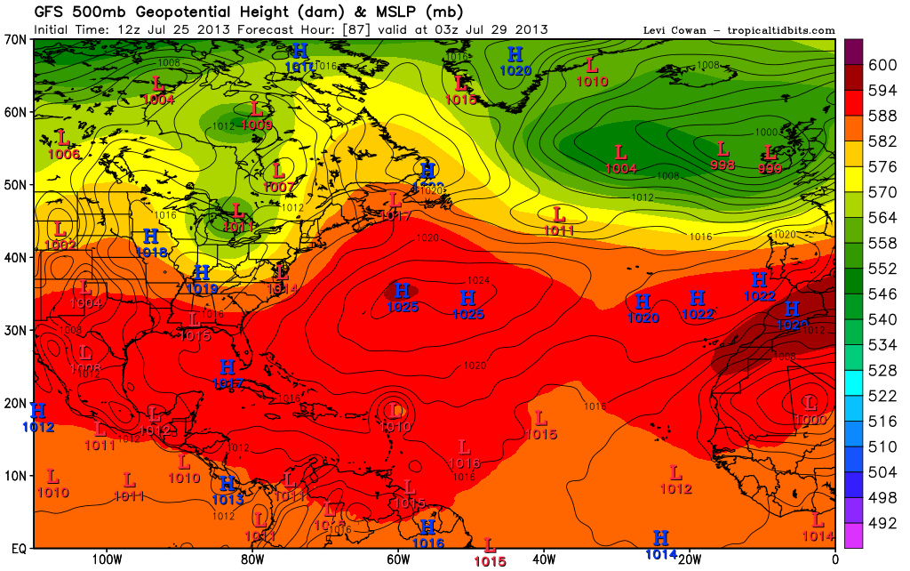
The latest 12Z GFS is rolling and it brings Dorian into Puerto Rico now.
This run has shifted south some from the 06Z run.
0 likes

Hmm slightly further south again on this run, IMO this run may have taken the trend a little too far to the south, still we will see, it'd be impressive at 16N/35W (roughly!) to hit PR, but who knows!
0 likes
Personal Forecast Disclaimer:
The posts in this forum are NOT official forecast and should not be used as such. They are just the opinion of the poster and may or may not be backed by sound meteorological data. They are NOT endorsed by any professional institution or storm2k.org. For official information, please refer to the NHC and NWS products
The posts in this forum are NOT official forecast and should not be used as such. They are just the opinion of the poster and may or may not be backed by sound meteorological data. They are NOT endorsed by any professional institution or storm2k.org. For official information, please refer to the NHC and NWS products
-
gatorcane
- S2K Supporter
- Posts: 23708
- Age: 48
- Joined: Sun Mar 13, 2005 3:54 pm
- Location: Boca Raton, FL
Re:
Hurricaneman wrote:This run is going to nail Hispaniola so if this happens Dorian may not be much for the US but be pretty significant in the islands
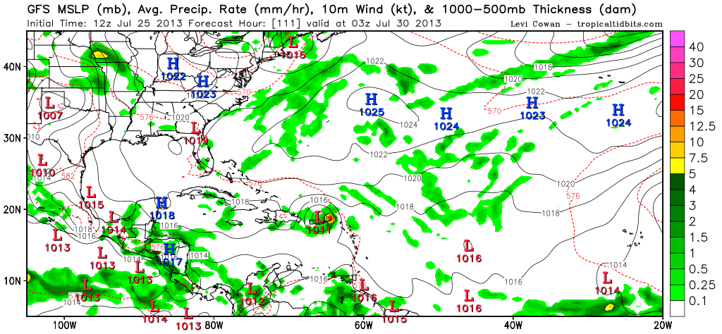
You may be right. Latest frames from the 12Z GFS run show it about to hit Hispaniola.
Also it's a weaker system as Alonyo pointed out could happen when it is run on the new computer.
0 likes
-
cycloneye

- Admin

- Posts: 149479
- Age: 69
- Joined: Thu Oct 10, 2002 10:54 am
- Location: San Juan, Puerto Rico
Re: ATL: DORIAN - Models
WCOSS is the new version running now.
0 likes
Visit the Caribbean-Central America Weather Thread where you can find at first post web cams,radars
and observations from Caribbean basin members Click Here
and observations from Caribbean basin members Click Here
-
CalmBeforeStorm
- Category 2

- Posts: 600
- Age: 72
- Joined: Tue Aug 10, 2004 7:55 pm
- Location: Stuart, Florida
Re:
Hurricaneman wrote:This run is going to nail Hispaniola so if this happens Dorian may not be much for the US but be pretty significant in the islands
Yep pretty much kills itself over Hispaniola on this run and doesn't seem to emerge at all.
I think this run is a good deal too far south now.
Quite a noticeable bend WSW on the 12z GFS between 60-84hrs, so that'll be the key as to whether this run is onto something or is utter nonsense...my guess is on the latter.
0 likes
Personal Forecast Disclaimer:
The posts in this forum are NOT official forecast and should not be used as such. They are just the opinion of the poster and may or may not be backed by sound meteorological data. They are NOT endorsed by any professional institution or storm2k.org. For official information, please refer to the NHC and NWS products
The posts in this forum are NOT official forecast and should not be used as such. They are just the opinion of the poster and may or may not be backed by sound meteorological data. They are NOT endorsed by any professional institution or storm2k.org. For official information, please refer to the NHC and NWS products

-
WeatherEmperor
- S2K Supporter
- Posts: 4806
- Age: 42
- Joined: Thu Sep 04, 2003 2:54 pm
- Location: South Florida
Re: ATL: DORIAN - Models
cycloneye wrote:WCOSS is the new version running now.
Can you provide a link for Wcoss?
Sent from my HTC EVO 4G LTE
0 likes
To be fair, Dorian is weakening on the 12z GFS before it even reaches Hispaniola, it has a sheared look to it (IE convection is displaced east of the low pressure)
0 likes
Personal Forecast Disclaimer:
The posts in this forum are NOT official forecast and should not be used as such. They are just the opinion of the poster and may or may not be backed by sound meteorological data. They are NOT endorsed by any professional institution or storm2k.org. For official information, please refer to the NHC and NWS products
The posts in this forum are NOT official forecast and should not be used as such. They are just the opinion of the poster and may or may not be backed by sound meteorological data. They are NOT endorsed by any professional institution or storm2k.org. For official information, please refer to the NHC and NWS products

-
AtlanticWind

- S2K Supporter
- Posts: 1898
- Age: 67
- Joined: Sun Aug 08, 2004 9:57 pm
- Location: Plantation,Fla
Re:
CalmBeforeStorm wrote:I can't get the new 12z GFS to appear on the NCEP site. Anyone have a different link for the GFS run?
http://www.tropicaltidbits.com/analysis ... 013072512/
0 likes
-
cycloneye
- Admin
- Posts: 149479
- Age: 69
- Joined: Thu Oct 10, 2002 10:54 am
- Location: San Juan, Puerto Rico
Re: ATL: DORIAN - Models
WeatherEmperor wrote:cycloneye wrote:WCOSS is the new version running now.
Can you provide a link for Wcoss?
Sent from my HTC EVO 4G LTE
Link here. Go to where it says latest news to see all the details of the new WCOSS.
http://mag.ncep.noaa.gov/?prevpage=inde ... L+GUIDANCE
0 likes
Visit the Caribbean-Central America Weather Thread where you can find at first post web cams,radars
and observations from Caribbean basin members Click Here
and observations from Caribbean basin members Click Here

Re: ATL: DORIAN - Models
I'm not sure if it's me or what..., but am I wrong in thinking that the full 12Z GFS run should be out by now?? With the new GFS update, has the link changed?
Also, with the GFS 6Z run a bit more south (and weaker), I get the impression that Dorian is about to hit the 500 pound (well really 500mb) wall. Looking at satellite just now, I am not sure if I am looking at a significant ribbon of Alto-Cumulus that looks to be fast approaching from the North and East. This would appear to be the present 594 ridge perhaps starting to press a bit further west and south as forecasted perhaps?? If this is so than I can see how Dorian in the near term, may be impacted and be forced on a more westerly course. The other potential result might in fact be a faster motion in the near term as well. Finally, if this were to come to fruition, than based on the more stable air it is ingesting for the next day or two, a more rapid forward motion would likely contribute to it having a harder time maintaining what little convection it has now and impact its vertical structure at least somewhat.
Also, with the GFS 6Z run a bit more south (and weaker), I get the impression that Dorian is about to hit the 500 pound (well really 500mb) wall. Looking at satellite just now, I am not sure if I am looking at a significant ribbon of Alto-Cumulus that looks to be fast approaching from the North and East. This would appear to be the present 594 ridge perhaps starting to press a bit further west and south as forecasted perhaps?? If this is so than I can see how Dorian in the near term, may be impacted and be forced on a more westerly course. The other potential result might in fact be a faster motion in the near term as well. Finally, if this were to come to fruition, than based on the more stable air it is ingesting for the next day or two, a more rapid forward motion would likely contribute to it having a harder time maintaining what little convection it has now and impact its vertical structure at least somewhat.
0 likes
Andy D
(For official information, please refer to the NHC and NWS products.)
(For official information, please refer to the NHC and NWS products.)

Re: ATL: DORIAN - Models
hmmm, maybe the EURO was not all that jacked up after all...should be coming out in a few hours....
0 likes
Who is online
Users browsing this forum: No registered users and 41 guests