BULLETIN
TROPICAL STORM ANDREA INTERMEDIATE ADVISORY NUMBER 3A
NWS NATIONAL HURRICANE CENTER MIAMI FL AL012013
700 AM CDT THU JUN 06 2013
...ANDREA MOVING CLOSER TO THE FLORIDA BIG BEND...
...POTENTIAL FOR TORNADOES ACROSS CENTRAL AND SOUTHERN FLORIDA
DURING THE MORNING...
SUMMARY OF 700 AM CDT...1200 UTC...INFORMATION
----------------------------------------------
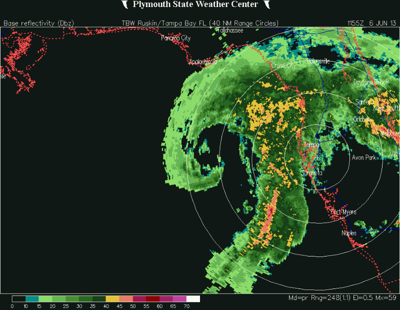
LOCATION...27.7N 85.1W
ABOUT 160 MI...255 KM W OF TAMPA FLORIDA
ABOUT 140 MI...225 KM S OF APALACHICOLA FLORIDA
MAXIMUM SUSTAINED WINDS...60 MPH...95 KM/H
PRESENT MOVEMENT...NNE OR 25 DEGREES AT 14 MPH...22 KM/H
MINIMUM CENTRAL PRESSURE...997 MB...29.44 INCHES
WATCHES AND WARNINGS
--------------------
CHANGES WITH THIS ADVISORY...
NONE
SUMMARY OF WATCHES AND WARNINGS IN EFFECT...
A TROPICAL STORM WARNING IS IN EFFECT FOR...
* THE WEST COAST OF FLORIDA FROM BOCA GRANDE TO INDIAN PASS
* FLAGLER BEACH FLORIDA TO CAPE CHARLES LIGHT VIRGINIA
* PAMLICO AND ALBEMARLE SOUNDS
* LOWER CHESAPEAKE BAY SOUTH OF NEW POINT COMFORT
A TROPICAL STORM WARNING MEANS THAT TROPICAL STORM CONDITIONS ARE
EXPECTED SOMEWHERE WITHIN THE WARNING AREA WITHIN 36 HOURS.
FOR STORM INFORMATION SPECIFIC TO YOUR AREA...INCLUDING POSSIBLE
INLAND WATCHES AND WARNINGS...PLEASE MONITOR PRODUCTS ISSUED BY
YOUR LOCAL NATIONAL WEATHER SERVICE FORECAST OFFICE.
DISCUSSION AND 48-HOUR OUTLOOK
------------------------------
AT 700 AM CDT...1200 UTC...THE CENTER OF TROPICAL STORM ANDREA WAS
LOCATED NEAR LATITUDE 27.7 NORTH...LONGITUDE 85.1 WEST. ANDREA IS
MOVING TOWARD THE NORTH-NORTHEAST NEAR 14 MPH...22 KM/H. A TURN
TOWARD THE NORTHEAST WITH AN ADDITIONAL INCREASE IN FORWARD SPEED
IS EXPECTED TODAY. ON THE FORECAST TRACK...THE CENTER OF ANDREA
WILL REACH THE COAST OF THE FLORIDA BIG BEND AREA LATER TODAY AND
THEN MOVE ACROSS SOUTHEASTERN GEORGIA...SOUTHEASTERN SOUTH CAROLINA
AND EASTERN NORTH CAROLINA BY FRIDAY.
MAXIMUM SUSTAINED WINDS ARE NEAR 60 MPH...95 KM/H...WITH HIGHER
GUSTS. NO SIGNIFICANT CHANGE IN STRENGTH IS FORECAST BEFORE THE
CENTER REACHES THE COAST LATER TODAY.
TROPICAL STORM FORCE WINDS EXTEND OUTWARD UP TO 140 MILES...220 KM
PRIMARILY TO THE EAST OF THE CENTER.
THE ESTIMATED MINIMUM CENTRAL PRESSURE IS 997 MB...29.44 INCHES.
HAZARDS AFFECTING LAND
----------------------
STORM SURGE...THE COMBINATION OF A STORM SURGE AND THE TIDE WILL
CAUSE NORMALLY DRY AREAS NEAR THE COAST TO BE FLOODED BY RISING
WATERS. THE WATER COULD REACH THE FOLLOWING HEIGHTS ABOVE GROUND
IF THE PEAK SURGE OCCURS AT THE TIME OF HIGH TIDE...
TAMPA BAY NORTHWARD TO APALACHICOLA...2 TO 5 FT
FLORIDA WEST COAST SOUTH OF TAMPA BAY...1 TO 2 FT
FLAGLER BEACH NORTH TO CAPE CHARLES LIGHT...1 TO 2 FT
THE DEEPEST WATER WILL OCCUR ALONG THE IMMEDIATE COAST NEAR AND TO
THE SOUTH OF THE FLORIDA LANDFALL LOCATION. SURGE-RELATED FLOODING
DEPENDS ON THE RELATIVE TIMING OF THE SURGE AND THE TIDAL CYCLE...
AND CAN VARY GREATLY OVER SHORT DISTANCES. FOR INFORMATION SPECIFIC
TO YOUR AREA...PLEASE SEE PRODUCTS ISSUED BY YOUR LOCAL NATIONAL
WEATHER SERVICE OFFICE.
RAINFALL...ANDREA IS EXPECTED TO PRODUCE TOTAL RAIN ACCUMULATIONS OF
3 TO 6 INCHES OVER MUCH OF THE FLORIDA PENINSULA...EASTERN PARTS OF
THE FLORIDA PANHANDLE...AND SOUTHEASTERN GEORGIA...WITH ISOLATED
MAXIMUM AMOUNTS OF 10 INCHES POSSIBLE. TOTAL RAIN ACCUMULATIONS OF
2 TO 4 INCHES ARE ALSO EXPECTED OVER EASTERN SOUTH CAROLINA...
EASTERN NORTH CAROLINA AND SOUTHEASTERN VIRGINIA.
WIND...TROPICAL STORM CONDITIONS ARE EXPECTED TO FIRST REACH THE
FLORIDA WEST COAST WITHIN THE WARNING AREA LATER TODAY...MAKING
OUTSIDE PREPARATIONS DIFFICULT OR DANGEROUS. THESE CONDITIONS WILL
GRADUALLY SPREAD NORTHWARD ALONG THE UNITED STATES EAST COAST
DURING THE NEXT 24 TO 36 HOURS.
TORNADOES...A FEW TORNADOES ARE POSSIBLE OVER THE FLORIDA PENINSULA
TODAY.
NEXT ADVISORY
-------------
NEXT COMPLETE ADVISORY...1000 AM CDT.
$$
FORECASTER BERG/BEVEN
ATL: ANDREA - Post-Tropical
Moderator: S2k Moderators
-
cycloneye

- Admin

- Posts: 149692
- Age: 69
- Joined: Thu Oct 10, 2002 10:54 am
- Location: San Juan, Puerto Rico
Re: ATL: ANDREA - Watches/Warnings/Advisories
0 likes
Visit the Caribbean-Central America Weather Thread where you can find at first post web cams,radars
and observations from Caribbean basin members Click Here
and observations from Caribbean basin members Click Here

Re: ATL: ANDREA - Tropical Storm
GCANE wrote:Palm Beach County, FL. Emerg. Crews reporting roofs missing and vehicles flipped over
Command set up at 76th Rd N. @ 130th (sounds like mult.injuries & bldgs damaged in area) unknown size of area damaged
http://twitter.com/res7cuefox5
Palm Beach County Fire Rescue Live Audio Feed
http://www.broadcastify.com/listen/feed/9219/web
that is near us. Hubby almost left during it, was rain wrapped, convinced him not to. Would have drivin into it.
0 likes
-
jaxfladude
- Category 5

- Posts: 1249
- Joined: Wed Aug 24, 2005 9:36 pm
- Location: Jacksonville, Fla
Re: ATL: ANDREA - Tropical Storm
GCANE wrote:GCANE wrote:Palm Beach County, FL. Emerg. Crews reporting roofs missing and vehicles flipped over
Command set up at 76th Rd N. @ 130th (sounds like mult.injuries & bldgs damaged in area) unknown size of area damaged
http://twitter.com/res7cuefox5
Palm Beach County Fire Rescue Live Audio Feed
http://www.broadcastify.com/listen/feed/9219/web
Traumatic injuries reported.


It has started the bad news...prayers, hope for the lowest amount of news like the above...
0 likes
Stay safe y'all
-
cycloneye
- Admin
- Posts: 149692
- Age: 69
- Joined: Thu Oct 10, 2002 10:54 am
- Location: San Juan, Puerto Rico
Re: ATL: ANDREA - Tropical Storm
...ANDREA MOVING CLOSER TO THE FLORIDA BIG BEND...
...POTENTIAL FOR TORNADOES ACROSS CENTRAL AND SOUTHERN FLORIDA
DURING THE MORNING...
SUMMARY OF 700 AM CDT...1200 UTC...INFORMATION
----------------------------------------------
LOCATION...27.7N 85.1W
ABOUT 160 MI...255 KM W OF TAMPA FLORIDA
ABOUT 140 MI...225 KM S OF APALACHICOLA FLORIDA
MAXIMUM SUSTAINED WINDS...60 MPH...95 KM/H
PRESENT MOVEMENT...NNE OR 25 DEGREES AT 14 MPH...22 KM/H
MINIMUM CENTRAL PRESSURE...997 MB...29.44 INCHES
0 likes
Visit the Caribbean-Central America Weather Thread where you can find at first post web cams,radars
and observations from Caribbean basin members Click Here
and observations from Caribbean basin members Click Here

Re: ATL: ANDREA - Tropical Storm
artist wrote:GCANE wrote:Palm Beach County, FL. Emerg. Crews reporting roofs missing and vehicles flipped over
Command set up at 76th Rd N. @ 130th (sounds like mult.injuries & bldgs damaged in area) unknown size of area damaged
http://twitter.com/res7cuefox5
Palm Beach County Fire Rescue Live Audio Feed
http://www.broadcastify.com/listen/feed/9219/web
that is near us. Hubby almost left during it, was rain wrapped, convinced him not to. Would have drivin into it.
Stay Safe!
0 likes

Re: ATL: ANDREA - Tropical Storm
Holy crap! That is one scary image.
0 likes
The preceding comments are never to be used as information to establish circumstances, plans or procedures for any weather related events. Only use official National Hurricane Center or National Weather Service information issued for your area.

-
northjaxpro

- S2K Supporter

- Posts: 8900
- Joined: Mon Sep 27, 2010 11:21 am
- Location: Jacksonville, FL
Yeah, Andrea is a very large storm indeed. Tropical cyclones that originate from monsoonal-type troughs usually are large in size and Andrea is fitting the bill with this example.
0 likes
NEVER, EVER SAY NEVER in the tropics and weather in general, and most importantly, with life itself!!
________________________________________________________________________________________
Fay 2008 Beryl 2012 Debby 2012 Colin 2016 Hermine 2016 Julia 2016 Matthew 2016 Irma 2017 Dorian 2019
________________________________________________________________________________________
Fay 2008 Beryl 2012 Debby 2012 Colin 2016 Hermine 2016 Julia 2016 Matthew 2016 Irma 2017 Dorian 2019
-
BoudreauxWPB

- Tropical Low

- Posts: 15
- Age: 60
- Joined: Mon Jun 25, 2012 9:03 am
- Location: Royal Palm Beach, Florida
Re: ATL: ANDREA - Tropical Storm
GCANE wrote:Palm Beach County, FL. Emerg. Crews reporting roofs missing and vehicles flipped over
Command set up at 76th Rd N. @ 130th (sounds like mult.injuries & bldgs damaged in area) unknown size of area damaged
http://twitter.com/res7cuefox5
Palm Beach County Fire Rescue Live Audio Feed
http://www.broadcastify.com/listen/feed/9219/web
Not too far from me, only about 8 miles from my home in western PBC. I can say, it was wicked this morning when I got up and left for work.
0 likes
Re: ATL: ANDREA - Tropical Storm
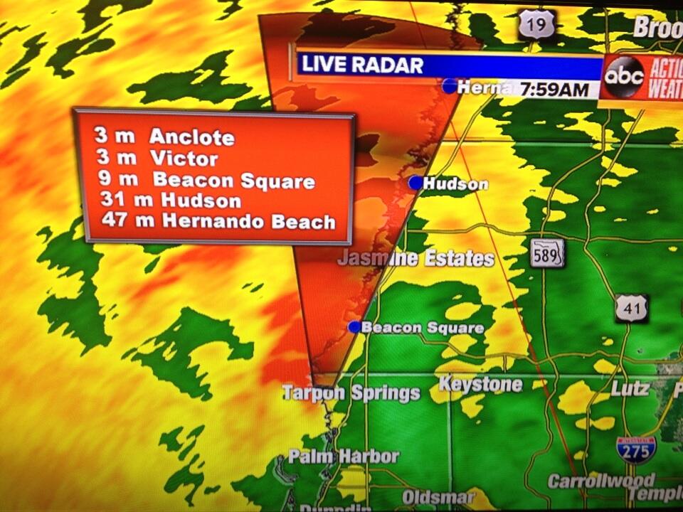
RADAR: Track for possible tornado moving north from Tarpon Springs
http://pbs.twimg.com/media/BMEz0RsCYAAjWGf.jpg:large
http://pbs.twimg.com/media/BMEz0RsCYAAjWGf.jpg:large
0 likes
-
northjaxpro
- S2K Supporter
- Posts: 8900
- Joined: Mon Sep 27, 2010 11:21 am
- Location: Jacksonville, FL
Also, radar and satellite imagery still indicates that Andrea's COC is wrapping very well, almost to a point where it appears she is trying to close off an eyewall. I don't think she will make it to hurricane status with the expected interaction with the upper level trough. However, Andrea certainly is doing her best to make up for lost time to organize just before landfall.
0 likes
NEVER, EVER SAY NEVER in the tropics and weather in general, and most importantly, with life itself!!
________________________________________________________________________________________
Fay 2008 Beryl 2012 Debby 2012 Colin 2016 Hermine 2016 Julia 2016 Matthew 2016 Irma 2017 Dorian 2019
________________________________________________________________________________________
Fay 2008 Beryl 2012 Debby 2012 Colin 2016 Hermine 2016 Julia 2016 Matthew 2016 Irma 2017 Dorian 2019
Re: ATL: ANDREA - Tropical Storm
Classic GOM dry slot should regulate the storm all the way in. Blustery here, no rain. Heavy rain that was forecast missed us to the west and north.
0 likes
-
caneman
Re: ATL: ANDREA - Tropical Storm
Indeed psyclone. Hunkering down here around Clw. Beach. Hope no Tornadoes.
0 likes
-
tolakram
- Admin
- Posts: 20186
- Age: 62
- Joined: Sun Aug 27, 2006 8:23 pm
- Location: Florence, KY (name is Mark)
Re: ATL: ANDREA - Tropical Storm
saved radar image

0 likes
M a r k
- - - - -
Join us in chat: Storm2K Chatroom Invite. Android and IOS apps also available.
The posts in this forum are NOT official forecasts and should not be used as such. Posts are NOT endorsed by any professional institution or STORM2K.org. For official information and forecasts, please refer to NHC and NWS products.
-
cycloneye
- Admin
- Posts: 149692
- Age: 69
- Joined: Thu Oct 10, 2002 10:54 am
- Location: San Juan, Puerto Rico
Re: ATL: ANDREA - Tropical Storm
PRELIMINARY LOCAL STORM REPORT
NATIONAL WEATHER SERVICE TALLAHASSEE FL
758 AM EDT THU JUN 06 2013
..TIME... ...EVENT... ...CITY LOCATION... ...LAT.LON...
..DATE... ....MAG.... ..COUNTY LOCATION..ST.. ...SOURCE....
..REMARKS..
0756 AM HEAVY RAIN 2 NE CARRABELLE 29.87N 84.64W
06/06/2013 M4.50 INCH FRANKLIN FL EMERGENCY MNGR
4.5 INCHES OF RAIN IN 5 HRS
0 likes
Visit the Caribbean-Central America Weather Thread where you can find at first post web cams,radars
and observations from Caribbean basin members Click Here
and observations from Caribbean basin members Click Here
Re: ATL: ANDREA - Tropical Storm
Weakening a little as it hits the coast.
Another one behind it though.
http://rammb.cira.colostate.edu/product ... 060415.jpg
Another one behind it though.
http://rammb.cira.colostate.edu/product ... 060415.jpg
0 likes


Re: ATL: ANDREA - Tropical Storm
Sanibel wrote:Classic GOM dry slot should regulate the storm all the way in. Blustery here, no rain. Heavy rain that was forecast missed us to the west and north.
I remember being in the dry slot in hernando county for gordon and charley
0 likes
Robbielyn McCrary
I know just about enough to sound like I know what I'm talking about sometimes. But for your safety please follow the nhc for truly professional forecasting.
I know just about enough to sound like I know what I'm talking about sometimes. But for your safety please follow the nhc for truly professional forecasting.
Re: ATL: ANDREA - Tropical Storm
robbielyn wrote:Sanibel wrote:Classic GOM dry slot should regulate the storm all the way in. Blustery here, no rain. Heavy rain that was forecast missed us to the west and north.
I remember being in the dry slot in hernando county for gordon and charley
Gordon (y2k) yes. Charley didn't touch hernando county but you're about to get bombed from this one
0 likes
Who is online
Users browsing this forum: No registered users and 84 guests