ATL: DORIAN - Post-Tropical - Discussion

Moderator: S2k Moderators

Message
Author
User avatar
northjaxpro
S2K Supporter
S2K Supporter
Posts: 8900
Joined: Mon Sep 27, 2010 11:21 am
Location: Jacksonville, FL

Re:

#1181 Postby northjaxpro » Thu Jul 25, 2013 2:15 pm

fci wrote:Surveillance mission makes sense. If there IS a Tropical Storm northeast of the islands still headed WNW, they are really going to want to sample the atmosphere all around it to get a fix on where it is headed. If there is no curve started shortly thereafter and it is still chugging towards the W or WNW, lots of questions to be answered on where he is headed.
Long time from now and plenty of time to cancel the mission.


Yeah, also, Dorian could be a sheared and weak mess of a storm by that time it nears its approach to the islands. A weaker Dorian would stay westward, with the chance of curving northward only being if it is a stronger, vertically stacked storm. It is 50/50 right now regarding the surveillance mission. It could get cancelled as well, dependent upon what kind of shape Dorian will be in 5 days. A due west motion from here would run it right into the islands and would kill the system off by the time it reaches Hispaniola.
0 likes   
NEVER, EVER SAY NEVER in the tropics and weather in general, and most importantly, with life itself!!

________________________________________________________________________________________

Fay 2008 Beryl 2012 Debby 2012 Colin 2016 Hermine 2016 Julia 2016 Matthew 2016 Irma 2017 Dorian 2019

User avatar
CalmBeforeStorm
Category 2
Category 2
Posts: 600
Age: 71
Joined: Tue Aug 10, 2004 7:55 pm
Location: Stuart, Florida

#1182 Postby CalmBeforeStorm » Thu Jul 25, 2013 2:20 pm

http://www.ssd.noaa.gov/PS/TROP/floater ... 0-lalo.jpg
~~~~~~~~
To me Dorian looks better organized then it did earlier.
0 likes   

User avatar
SFLcane
S2K Supporter
S2K Supporter
Posts: 10163
Age: 47
Joined: Sat Jun 05, 2010 1:44 pm
Location: Lake Worth Florida

Re: ATL: DORIAN - Tropical Storm - Discussion

#1183 Postby SFLcane » Thu Jul 25, 2013 2:20 pm

Convection flaring up over the llc CDO expanding

Image
Last edited by SFLcane on Thu Jul 25, 2013 2:23 pm, edited 1 time in total.
0 likes   

User avatar
northjaxpro
S2K Supporter
S2K Supporter
Posts: 8900
Joined: Mon Sep 27, 2010 11:21 am
Location: Jacksonville, FL

#1184 Postby northjaxpro » Thu Jul 25, 2013 2:22 pm

Dorian , compared to earlier today, does look better right now. Convection is building again around the center of circulation.
0 likes   
NEVER, EVER SAY NEVER in the tropics and weather in general, and most importantly, with life itself!!

________________________________________________________________________________________

Fay 2008 Beryl 2012 Debby 2012 Colin 2016 Hermine 2016 Julia 2016 Matthew 2016 Irma 2017 Dorian 2019

User avatar
Weatherboy1
Category 5
Category 5
Posts: 1189
Age: 49
Joined: Mon Jul 05, 2004 1:50 pm
Location: Jupiter/Sarasota, FL

#1185 Postby Weatherboy1 » Thu Jul 25, 2013 2:22 pm

Newest NWS discussion out of Miami this afternoon continues to talk about trough lifting out and ridge building in early next week. Could block any recurvature if this verifies ... assuming there's a system left at that point. Intensity forecasting in the long range is very iffy, so hard to know if global models are on to something by weakening Dorian or if he can maintain his strength over time ...

AN UPPER LEVEL TROUGH IS FORECAST TO
DIG INTO THE SOUTHEAST ON SUNDAY...WITH A SHORTWAVE SLIDING EAST
SOUTHEAST AROUND THE BASE OF THE TROUGH INTO NORTHERN AND CENTRAL
FLORIDA. THE EDGE OF THE RIDGE IS FORECAST TO BUILD EAST TO ALONG
OR JUST TO THE EAST OF SOUTH FLORIDA...WITH RELATIVELY LIGHT FLOW
ALOFT. THIS WILL ALLOW FOR SCATTERED DIURNALLY DRIVEN
THUNDERSTORMS TO DEVELOP ALONG THE SEA BREEZE BOUNDARIES. THE
TROUGH WILL THEN LIFT OUT...WITH THE RIDGE BUILDING ACROSS THE
REGION THROUGH THE MIDDLE OF THE WEEK.

IT IS TOO EARLY TO SAY IF TROPICAL STORM DORIAN WILL HAVE ANY
IMPACTS ON SOUTH FLORIDA LATER IN THE WEEK...BUT INTERESTS IN
SOUTH FLORIDA SHOULD CONTINUE TO MONITOR THE LATEST FORECASTS FROM
THE NATIONAL HURRICANE CENTER.
0 likes   

Aric Dunn
Category 5
Category 5
Posts: 21238
Age: 42
Joined: Sun Sep 19, 2004 9:58 pm
Location: Ready for the Chase.
Contact:

#1186 Postby Aric Dunn » Thu Jul 25, 2013 2:25 pm

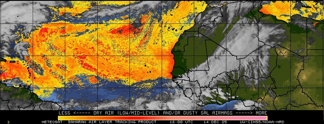
trying to make a come back. may have just been a small surge of sal looks like it might be abating some...
0 likes   
Note: If I make a post that is brief. Please refer back to previous posts for the analysis or reasoning. I do not re-write/qoute what my initial post said each time.
If there is nothing before... then just ask :)

Space & Atmospheric Physicist, Embry-Riddle Aeronautical University,
I believe the sky is falling...

jlauderdal
S2K Supporter
S2K Supporter
Posts: 7183
Joined: Wed May 19, 2004 5:46 am
Location: NE Fort Lauderdale
Contact:

Re:

#1187 Postby jlauderdal » Thu Jul 25, 2013 2:28 pm

Weatherboy1 wrote:Newest NWS discussion out of Miami this afternoon continues to talk about trough lifting out and ridge building in early next week. Could block any recurvature if this verifies ... assuming there's a system left at that point. Intensity forecasting in the long range is very iffy, so hard to know if global models are on to something by weakening Dorian or if he can maintain his strength over time ...

AN UPPER LEVEL TROUGH IS FORECAST TO
DIG INTO THE SOUTHEAST ON SUNDAY...WITH A SHORTWAVE SLIDING EAST
SOUTHEAST AROUND THE BASE OF THE TROUGH INTO NORTHERN AND CENTRAL
FLORIDA. THE EDGE OF THE RIDGE IS FORECAST TO BUILD EAST TO ALONG
OR JUST TO THE EAST OF SOUTH FLORIDA...WITH RELATIVELY LIGHT FLOW
ALOFT. THIS WILL ALLOW FOR SCATTERED DIURNALLY DRIVEN
THUNDERSTORMS TO DEVELOP ALONG THE SEA BREEZE BOUNDARIES. THE
TROUGH WILL THEN LIFT OUT...WITH THE RIDGE BUILDING ACROSS THE
REGION THROUGH THE MIDDLE OF THE WEEK.

IT IS TOO EARLY TO SAY IF TROPICAL STORM DORIAN WILL HAVE ANY
IMPACTS ON SOUTH FLORIDA LATER IN THE WEEK...BUT INTERESTS IN
SOUTH FLORIDA SHOULD CONTINUE TO MONITOR THE LATEST FORECASTS FROM
THE NATIONAL HURRICANE CENTER.


they seem bullish on it by the mere fact they are mentioning it this far out
0 likes   

Aric Dunn
Category 5
Category 5
Posts: 21238
Age: 42
Joined: Sun Sep 19, 2004 9:58 pm
Location: Ready for the Chase.
Contact:

Re: ATL: DORIAN - Tropical Storm - Discussion

#1188 Postby Aric Dunn » Thu Jul 25, 2013 2:29 pm

The easterly surge of sal can be seen here... if it can keep it out there is really nothing to its west in terms of sal.. unlike chantal..

Image
0 likes   
Note: If I make a post that is brief. Please refer back to previous posts for the analysis or reasoning. I do not re-write/qoute what my initial post said each time.
If there is nothing before... then just ask :)

Space & Atmospheric Physicist, Embry-Riddle Aeronautical University,
I believe the sky is falling...

User avatar
blp
Category 5
Category 5
Posts: 2840
Age: 46
Joined: Thu Sep 09, 2004 7:51 pm
Location: Miami, FL
Contact:

Re: ATL: DORIAN - Models

#1189 Postby blp » Thu Jul 25, 2013 2:34 pm

AtlanticWind wrote:The 12z global models (GFS CMC Nogaps Euro) all show a weak storm or wave.


I would not focus on intensity at this point considering how bad they all did with this storm a few days ago. Everyone one of them had this either opening up or a week system. This thing is almost a hurricane.

I read earlier a post by Wxman57 that made a lot of sense the intensity models sample a large area and you might have unfavorable conditions 100 miles away and not over the system so I think with this small system the intensity forecast is going to be quite tricky for the models.
0 likes   
The following post is NOT an official forecast and should not be used as such. It is just the opinion of the poster and may or may not be backed by sound meteorological data. It is NOT endorsed by any professional institution including storm2k.org For Official Information please refer to the NHC and NWS products.

Aric Dunn
Category 5
Category 5
Posts: 21238
Age: 42
Joined: Sun Sep 19, 2004 9:58 pm
Location: Ready for the Chase.
Contact:

#1190 Postby Aric Dunn » Thu Jul 25, 2013 2:35 pm

notice the upper level cirus clouds expanding westward... tells up that the de coupling earlier was from a easterly surge in the low levels and not upper level sw winds

http://www.ssd.noaa.gov/goes/east/tatl/loop-avn.html
0 likes   
Note: If I make a post that is brief. Please refer back to previous posts for the analysis or reasoning. I do not re-write/qoute what my initial post said each time.
If there is nothing before... then just ask :)

Space & Atmospheric Physicist, Embry-Riddle Aeronautical University,
I believe the sky is falling...

User avatar
ROCK
Category 5
Category 5
Posts: 9484
Age: 54
Joined: Tue Aug 17, 2004 7:30 am
Location: Kemah, Texas

Re: ATL: DORIAN - Models

#1191 Postby ROCK » Thu Jul 25, 2013 2:37 pm

I spy Texas in the latest model map with some GFS ensembles heading in that direction.....hmmm...if a GOM solution verified then CLIMO huggers are going to go into hiding.... :lol:
0 likes   

User avatar
StormTracker
S2K Supporter
S2K Supporter
Posts: 2903
Age: 59
Joined: Thu Jun 29, 2006 6:06 am
Location: Quail Heights(Redlands), FL.

Re: ATL: DORIAN - Tropical Storm - Discussion

#1192 Postby StormTracker » Thu Jul 25, 2013 2:40 pm

:uarrow:
Yeah Aric, on the loop earlier today you could see where Dorian ingested a decent amount of SAL from the west and that's probably part of the reason (along with some mild shear) that he is having some problems in the short term.
0 likes   
Something's wrong when you regret, things that haven't happened yet!

User avatar
blp
Category 5
Category 5
Posts: 2840
Age: 46
Joined: Thu Sep 09, 2004 7:51 pm
Location: Miami, FL
Contact:

Re: ATL: DORIAN - Tropical Storm - Discussion

#1193 Postby blp » Thu Jul 25, 2013 2:41 pm

Aric Dunn wrote:The easterly surge of sal can be seen here... if it can keep it out there is really nothing to its west in terms of sal.. unlike chantal..

http://tropic.ssec.wisc.edu/real-time/sal/splitE.jpg[/img]


I think it will keep it at bay with that mositure bubble it is in. It helps that it is now reaching warmer waters.

Image
0 likes   
The following post is NOT an official forecast and should not be used as such. It is just the opinion of the poster and may or may not be backed by sound meteorological data. It is NOT endorsed by any professional institution including storm2k.org For Official Information please refer to the NHC and NWS products.

User avatar
Tireman4
S2K Supporter
S2K Supporter
Posts: 5853
Age: 59
Joined: Fri Jun 30, 2006 1:08 pm
Location: Humble, Texas
Contact:

Re: ATL: DORIAN - Models

#1194 Postby Tireman4 » Thu Jul 25, 2013 2:43 pm

ROCK wrote:I spy Texas in the latest model map with some GFS ensembles heading in that direction.....hmmm...if a GOM solution verified then CLIMO huggers are going to go into hiding.... :lol:


Stop that Rock. No....LOL....just for that, go run a mile. :P.....LOL.
0 likes   

User avatar
cycloneye
Admin
Admin
Posts: 145422
Age: 68
Joined: Thu Oct 10, 2002 10:54 am
Location: San Juan, Puerto Rico

Re: ATL: DORIAN - Tropical Storm - Discussion

#1195 Postby cycloneye » Thu Jul 25, 2013 2:43 pm

Dorian is a pesky storm dealing with all kind of adversities but is still hanging there.
0 likes   
Visit the Caribbean-Central America Weather Thread where you can find at first post web cams,radars
and observations from Caribbean basin members Click Here

User avatar
fci
S2K Supporter
S2K Supporter
Posts: 3324
Joined: Tue Sep 14, 2004 10:29 am
Location: Lake Worth, FL

Re: ATL: DORIAN - Models

#1196 Postby fci » Thu Jul 25, 2013 2:48 pm

ROCK wrote:I spy Texas in the latest model map with some GFS ensembles heading in that direction.....hmmm...if a GOM solution verified then CLIMO huggers are going to go into hiding.... :lol:


Well being one of those that relies on Climo most of the time; I would be shocked if the GOM verified for Dorian.
Wxman57 showed the map on one of the threads and Dorian would be the first to do that.
So, yeah, I will probably join witness protection if that happens....... 8-)
0 likes   

User avatar
northjaxpro
S2K Supporter
S2K Supporter
Posts: 8900
Joined: Mon Sep 27, 2010 11:21 am
Location: Jacksonville, FL

#1197 Postby northjaxpro » Thu Jul 25, 2013 2:51 pm

:uarrow: cycloneye, for me, I have always been fascinated by these tiny, smaller scaled tropical cyclones like Dorian through the years. These systems seem to always have tricks up their sleeve. All tropical cyclones have that characterisic obviously, but I think of small tropical cyclones like Humberto and how it exploded in less than 24 hours to being the fastest intensifying cyclone before landfall ever. These small tropical cyclones can be very tricky in forecasting, which is why I am so intrigued how Dorian will fare as time progresses.
Last edited by northjaxpro on Thu Jul 25, 2013 2:54 pm, edited 2 times in total.
0 likes   
NEVER, EVER SAY NEVER in the tropics and weather in general, and most importantly, with life itself!!

________________________________________________________________________________________

Fay 2008 Beryl 2012 Debby 2012 Colin 2016 Hermine 2016 Julia 2016 Matthew 2016 Irma 2017 Dorian 2019

User avatar
wzrgirl1
S2K Supporter
S2K Supporter
Posts: 1325
Joined: Sat Sep 04, 2004 6:44 am
Location: Pembroke Pines, Florida

Re: ATL: DORIAN - Tropical Storm - Discussion

#1198 Postby wzrgirl1 » Thu Jul 25, 2013 2:52 pm

So I have reservations at a really nice hotel in Key West for one week from tomorrow. Cancel, go, or wait a couple more days? I think I can cancel 72 hours out. Thanks in advance.
0 likes   

User avatar
fci
S2K Supporter
S2K Supporter
Posts: 3324
Joined: Tue Sep 14, 2004 10:29 am
Location: Lake Worth, FL

Re: Re:

#1199 Postby fci » Thu Jul 25, 2013 2:53 pm

jlauderdal wrote:
Weatherboy1 wrote:Newest NWS discussion out of Miami this afternoon continues to talk about trough lifting out and ridge building in early next week. Could block any recurvature if this verifies ... assuming there's a system left at that point. Intensity forecasting in the long range is very iffy, so hard to know if global models are on to something by weakening Dorian or if he can maintain his strength over time ...

AN UPPER LEVEL TROUGH IS FORECAST TO
DIG INTO THE SOUTHEAST ON SUNDAY...WITH A SHORTWAVE SLIDING EAST
SOUTHEAST AROUND THE BASE OF THE TROUGH INTO NORTHERN AND CENTRAL
FLORIDA. THE EDGE OF THE RIDGE IS FORECAST TO BUILD EAST TO ALONG
OR JUST TO THE EAST OF SOUTH FLORIDA...WITH RELATIVELY LIGHT FLOW
ALOFT. THIS WILL ALLOW FOR SCATTERED DIURNALLY DRIVEN
THUNDERSTORMS TO DEVELOP ALONG THE SEA BREEZE BOUNDARIES. THE
TROUGH WILL THEN LIFT OUT...WITH THE RIDGE BUILDING ACROSS THE
REGION THROUGH THE MIDDLE OF THE WEEK.

IT IS TOO EARLY TO SAY IF TROPICAL STORM DORIAN WILL HAVE ANY
IMPACTS ON SOUTH FLORIDA LATER IN THE WEEK...BUT INTERESTS IN
SOUTH FLORIDA SHOULD CONTINUE TO MONITOR THE LATEST FORECASTS FROM
THE NATIONAL HURRICANE CENTER.


they seem bullish on it by the mere fact they are mentioning it this far out


The Miami NWS used to shy away from mentioning systems this far out but lately they have been much more up front than they used to be. Even earlier this year with Chantal; they were mentioning her several days out with reminders to always be ready. Used to have to rely on Melbourne for candor but Miami is stepping up nowadays.
0 likes   
Personal Forecast Disclaimer:
My posts are just my opinion and are most likely not backed by sound meteorological data. They are NOT endorsed by any professional institution or storm2k.org. For official information, please refer to the NHC and NWS products.
Bottom line is that I am just expressing my opinion!!!

Aric Dunn
Category 5
Category 5
Posts: 21238
Age: 42
Joined: Sun Sep 19, 2004 9:58 pm
Location: Ready for the Chase.
Contact:

#1200 Postby Aric Dunn » Thu Jul 25, 2013 2:53 pm

latest frame convection really beginning to make a nice come back

http://www.ssd.noaa.gov/goes/east/tatl/loop-avn.html
0 likes   
Note: If I make a post that is brief. Please refer back to previous posts for the analysis or reasoning. I do not re-write/qoute what my initial post said each time.
If there is nothing before... then just ask :)

Space & Atmospheric Physicist, Embry-Riddle Aeronautical University,
I believe the sky is falling...


Return to “2013”

Who is online

Users browsing this forum: No registered users and 3 guests