ATL: DORIAN - Post-Tropical - Discussion

Moderator: S2k Moderators

Message
Author
ozonepete
Professional-Met
Professional-Met
Posts: 4743
Joined: Mon Sep 07, 2009 3:23 pm
Location: From Ozone Park, NYC / Now in Brooklyn, NY

Re: ATL: DORIAN - Tropical Storm - Discussion

#1381 Postby ozonepete » Thu Jul 25, 2013 9:14 pm

wxman57 wrote:Struggling now more than it was this afternoon.


growing pains. :wink:
0 likes   

torrea40

Re: ATL: DORIAN - Tropical Storm - Discussion

#1382 Postby torrea40 » Thu Jul 25, 2013 9:16 pm

BEST TRACK
AL, 04, 2013072600, , BEST, 0, 164N, 387W, 50, 999, TS
0 likes   

User avatar
boca
Category 5
Category 5
Posts: 6367
Age: 60
Joined: Mon Dec 15, 2003 8:49 am
Location: Boca Raton,FL

Re: ATL: DORIAN - Models

#1383 Postby boca » Thu Jul 25, 2013 9:18 pm

If Dorian makes it even to the Bahamas Ill be surprised,but I agree with Blownaway that I trough will probably catch it away from the US because we been getting tyrough every 7 to 10 days the pattewrn isnt the same as it was the month of June and part of July.
0 likes   

User avatar
cycloneye
Admin
Admin
Posts: 145515
Age: 68
Joined: Thu Oct 10, 2002 10:54 am
Location: San Juan, Puerto Rico

Re: ATL: DORIAN - Tropical Storm - Discussion

#1384 Postby cycloneye » Thu Jul 25, 2013 9:18 pm

torrea40 wrote:BEST TRACK
AL, 04, 2013072600, , BEST, 0, 164N, 387W, 50, 999, TS


I posted that almost two hours ago. There have not been further updates to the intensity.
0 likes   
Visit the Caribbean-Central America Weather Thread where you can find at first post web cams,radars
and observations from Caribbean basin members Click Here

User avatar
stormhunter7
Category 2
Category 2
Posts: 762
Joined: Mon May 26, 2008 3:13 pm
Location: Panama City Beach, Florida
Contact:

Re: ATL: DORIAN - Tropical Storm - Discussion

#1385 Postby stormhunter7 » Thu Jul 25, 2013 9:18 pm

ozonepete wrote:
stormhunter7 wrote:Still think mid level winds and the dry air coming in from north are winning out now. And the forward speed of 20mph its just to fast I think for vertical structure to improve for the near term.


There is no dry air to the north. There's some to the west but it's moving ahead at the same speed that Dorian is.


The air mass to the direct north... 150+ miles to the north and the NE appears to be cool and dry? Based on the sat data I have seen. http://tropic.ssec.wisc.edu/real-time/m ... t72hrs.gif
Last edited by stormhunter7 on Thu Jul 25, 2013 9:21 pm, edited 2 times in total.
0 likes   
The following post is NOT an official forecast and should not be used as such. It is just the opinion of the poster and may or may not be backed by sound meteorological data. It is NOT endorsed by any professional institution including storm2k.org For Official Information please refer to the NHC and NWS products. http://www.nhc.noaa.gov

User avatar
ROCK
Category 5
Category 5
Posts: 9484
Age: 54
Joined: Tue Aug 17, 2004 7:30 am
Location: Kemah, Texas

Re: ATL: DORIAN - Models

#1386 Postby ROCK » Thu Jul 25, 2013 9:19 pm

yeah the shear is going to be high with that TUTT sitting over the Bahamas.....


trend has been west and continues...IMO the whole GOM coast is in play along with Mexico and CA.....and maybe the EC...
0 likes   

TheStormExpert

#1387 Postby TheStormExpert » Thu Jul 25, 2013 9:19 pm

I'm really interested to see what the 11pm forecast will hold, especially the discussion.
0 likes   

User avatar
ROCK
Category 5
Category 5
Posts: 9484
Age: 54
Joined: Tue Aug 17, 2004 7:30 am
Location: Kemah, Texas

Re: ATL: DORIAN - Tropical Storm - Discussion

#1388 Postby ROCK » Thu Jul 25, 2013 9:23 pm

I have seen TS's hold together at 20MPH...not unheard of....now 30MPH like Chantal that was WAYYYY to fast....He is firing convection now and doing a little flexing.... :D
0 likes   

TheStormExpert

Re: ATL: DORIAN - Models

#1389 Postby TheStormExpert » Thu Jul 25, 2013 9:24 pm

ROCK wrote:yeah the shear is going to be high with that TUTT sitting over the Bahamas.....


trend has been west and continues...IMO the whole GOM coast is in play along with Mexico and CA.....and maybe the EC...

I thought that TUTT was going to weaken this weekend?
0 likes   

hurricaneCW
Category 5
Category 5
Posts: 1794
Joined: Wed Mar 03, 2010 6:20 am
Location: Toms River, NJ

Re: ATL: DORIAN - Models

#1390 Postby hurricaneCW » Thu Jul 25, 2013 9:25 pm

Surprised everyone thinks it'll recurve, the guidance certainly isn't showing that and given that its unlikely to become very strong, it's more likely to head further west.

I think it could impact Florida and the SE.
0 likes   

ozonepete
Professional-Met
Professional-Met
Posts: 4743
Joined: Mon Sep 07, 2009 3:23 pm
Location: From Ozone Park, NYC / Now in Brooklyn, NY

Re: ATL: DORIAN - Tropical Storm - Discussion

#1391 Postby ozonepete » Thu Jul 25, 2013 9:25 pm

stormhunter7 wrote:
ozonepete wrote:
stormhunter7 wrote:Still think mid level winds and the dry air coming in from north are winning out now. And the forward speed of 20mph its just to fast I think for vertical structure to improve for the near term.


There is no dry air to the north. There's some to the west but it's moving ahead at the same speed that Dorian is.


The air mass to the direct north... 150+ miles to the north and the NE appears to be cool and dry? Based on the sat data I have seen. http://tropic.ssec.wisc.edu/real-time/m ... t72hrs.gif
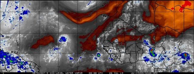
You need to use this satellite image of mid-level dry air, not the other satellites people have posted which show upper level dry air or standard water vapor loops which don't show mid-level dry air very well. I don't see any dry air of any significance to the north on this image - it's all to the west. Also, satellite images don't really show "cool and dry" air, right? :) Look at the next post. :)


Image
Last edited by ozonepete on Thu Jul 25, 2013 9:34 pm, edited 2 times in total.
0 likes   

User avatar
ROCK
Category 5
Category 5
Posts: 9484
Age: 54
Joined: Tue Aug 17, 2004 7:30 am
Location: Kemah, Texas

Re: ATL: DORIAN - Models

#1392 Postby ROCK » Thu Jul 25, 2013 9:28 pm

TheStormExpert wrote:
ROCK wrote:yeah the shear is going to be high with that TUTT sitting over the Bahamas.....


trend has been west and continues...IMO the whole GOM coast is in play along with Mexico and CA.....and maybe the EC...

I thought that TUTT was going to weaken this weekend?


we will see...might not even make it that far....the EURO tonight might help....got the 00Z GFS and NAVGEM coming up...
0 likes   

User avatar
ROCK
Category 5
Category 5
Posts: 9484
Age: 54
Joined: Tue Aug 17, 2004 7:30 am
Location: Kemah, Texas

Re: ATL: DORIAN - Models

#1393 Postby ROCK » Thu Jul 25, 2013 9:30 pm

hurricaneCW wrote:Surprised everyone thinks it'll recurve, the guidance certainly isn't showing that and given that its unlikely to become very strong, it's more likely to head further west.

I think it could impact Florida and the SE.


:uarrow: agree....basically from Tampico to New England is my gut feeling right now...
0 likes   

ozonepete
Professional-Met
Professional-Met
Posts: 4743
Joined: Mon Sep 07, 2009 3:23 pm
Location: From Ozone Park, NYC / Now in Brooklyn, NY

Re: ATL: DORIAN - Tropical Storm - Discussion

#1394 Postby ozonepete » Thu Jul 25, 2013 9:31 pm

:uarrow: Oh, I see. Sorry, I missed your linked image. My bad. You posted precipitable water. That's not a satellite image but a special composite showing areas where the atmosphere has a lot of potential for precipitation to fall based on moisture content at different levels. It is actually a very good proxy for finding dry and moist air that can be ingested by TCs. But on that chart the dry air to the northeast is hundreds of miles away, not 150 miles.
0 likes   

User avatar
StormTracker
S2K Supporter
S2K Supporter
Posts: 2903
Age: 59
Joined: Thu Jun 29, 2006 6:06 am
Location: Quail Heights(Redlands), FL.

Re: Re:

#1395 Postby StormTracker » Thu Jul 25, 2013 9:31 pm

Blown Away wrote:
panamatropicwatch wrote:
mvtrucking wrote:Hate to see this storm get anywhere near the Gulf, Fl or the East Coast, hope it just heads out to sea.

That would be bad, the whole state could use a break from rain.[/]

Local officials are panicking to empty Lake Okeechobee, a strong system moving over the lake now could spell trouble for the dike...


I mentioned a couple of days ago that they were going to have to drain some water off because 15.50 ft. is the highest safe level as far as the dike is concerned! Today it was at 15.62 ft. w/rain today!
0 likes   
Something's wrong when you regret, things that haven't happened yet!

User avatar
Blown Away
S2K Supporter
S2K Supporter
Posts: 10152
Joined: Wed May 26, 2004 6:17 am

Re: ATL: DORIAN - Models

#1396 Postby Blown Away » Thu Jul 25, 2013 9:31 pm

Image
00z...I'm predicting a slight nudge S of the 11pm NHC track at day 4/5, but still N of Hispaniola.
0 likes   
Hurricane Eye Experience: David 79, Irene 99, Frances 04, Jeanne 04, Wilma 05... EYE COMING MY WAY IN 2024…
Hurricane Brush Experience: Andrew 92, Erin 95, Floyd 99, Matthew 16, Irma 17, Ian 22, Nicole 22…

User avatar
perk
Category 3
Category 3
Posts: 825
Joined: Mon Aug 09, 2004 9:35 am
Location: Richmond Texas

Re: ATL: DORIAN - Models

#1397 Postby perk » Thu Jul 25, 2013 9:32 pm

boca wrote:If Dorian makes it even to the Bahamas Ill be surprised,but I agree with Blownaway that I trough will probably catch it away from the US because we been getting tyrough every 7 to 10 days the pattewrn isnt the same as it was the month of June and part of July.


But the models does'nt back up your claim,at least not yet.
Last edited by perk on Thu Jul 25, 2013 9:35 pm, edited 1 time in total.
0 likes   

sharoncapecod
Tropical Wave
Tropical Wave
Posts: 5
Joined: Sat Sep 08, 2012 3:48 pm

Re: Re:

#1398 Postby sharoncapecod » Thu Jul 25, 2013 9:35 pm

Hybridstorm_November2001 wrote:
Blown Away wrote:
HouTXmetro wrote:Caribbean Cruiser?


Before it's all said and done, I'm guessing recurve away from CONUS...


I couldn't agree with you more. This one is either a full recurve, or maybe New England/Nova Scotia.

The following post is NOT an official forecast and should not be used as such. It is just the opinion of the poster and may or may not be backed by sound meteorological data. It is NOT endorsed by any professional institution including storm2k.org For Official Information please refer to the NHC and NWS products.


Been reading all the posts and learning alot Thank You! Yesterday the GFS had Dorian close to Cape Cod, today not. Is it possible for a NE/NS hit? What makes you feel this way? Any insight would be great..
0 likes   

User avatar
ROCK
Category 5
Category 5
Posts: 9484
Age: 54
Joined: Tue Aug 17, 2004 7:30 am
Location: Kemah, Texas

Re: ATL: DORIAN - Tropical Storm - Discussion

#1399 Postby ROCK » Thu Jul 25, 2013 9:37 pm

sst's should not be a problem going forward.....its the fast easterlies, little dry air and shear down the road.....

http://wxmaps.org/pix/hurpot.html#ATL


oh how I miss the days when we had an eye to track...... :D
0 likes   

User avatar
cycloneye
Admin
Admin
Posts: 145515
Age: 68
Joined: Thu Oct 10, 2002 10:54 am
Location: San Juan, Puerto Rico

Re: ATL: DORIAN - Advisories

#1400 Postby cycloneye » Thu Jul 25, 2013 9:42 pm

BULLETIN
TROPICAL STORM DORIAN ADVISORY NUMBER 8
NWS NATIONAL HURRICANE CENTER MIAMI FL AL042013
1100 PM AST THU JUL 25 2013

...DORIAN A LITTLE WEAKER...


SUMMARY OF 1100 PM AST...0300 UTC...INFORMATION
-----------------------------------------------
LOCATION...16.6N 39.6W
ABOUT 1550 MI...2500 KM E OF THE NORTHERN LEEWARD ISLANDS
MAXIMUM SUSTAINED WINDS...50 MPH...85 KM/H
PRESENT MOVEMENT...WNW OR 285 DEGREES AT 20 MPH...32 KM/H
MINIMUM CENTRAL PRESSURE...1001 MB...29.56 INCHES


WATCHES AND WARNINGS
--------------------
THERE ARE NO COASTAL WATCHES OR WARNINGS IN EFFECT.

INTERESTS IN THE NORTHERN LEEWARD ISLANDS SHOULD MONITOR THE
PROGRESS OF DORIAN.


DISCUSSION AND 48-HOUR OUTLOOK
------------------------------
AT 1100 PM AST...0300 UTC...THE CENTER OF TROPICAL STORM DORIAN WAS
LOCATED NEAR LATITUDE 16.6 NORTH...LONGITUDE 39.6 WEST. DORIAN IS
MOVING TOWARD THE WEST-NORTHWEST NEAR 20 MPH...32 KM/H. A TURN
TOWARD THE WEST WITH AN INCREASE IN FORWARD SPEED IS FORECAST ON
FRIDAY.

MAXIMUM SUSTAINED WINDS HAVE DECREASED TO NEAR 50 MPH...85 KM/H...
WITH HIGHER GUSTS. LITTLE CHANGE IN STRENGTH IS FORECAST THROUGH
LATE SATURDAY.

TROPICAL STORM FORCE WINDS EXTEND OUTWARD UP TO 60 MILES...95 KM
FROM THE CENTER.

THE ESTIMATED MINIMUM CENTRAL PRESSURE IS 1001 MB...29.56 INCHES.


HAZARDS AFFECTING LAND
----------------------
NONE.


NEXT ADVISORY
-------------
NEXT COMPLETE ADVISORY...500 AM AST.

$$
FORECASTER BERG


TROPICAL STORM DORIAN DISCUSSION NUMBER 8
NWS NATIONAL HURRICANE CENTER MIAMI FL AL042013
1100 PM AST THU JUL 25 2013

THE CONVECTIVE STRUCTURE OF DORIAN HAS NOT BEEN PARTICULARLY
ORGANIZED THIS EVENING...AND RECENT MICROWAVE IMAGERY INDICATES
THAT THE LOW-LEVEL CENTER LIES TO THE SOUTHWEST OF THE DEEP
CONVECTION. A 2340 UTC ASCAT-B OVERPASS INDICATES THAT DORIAN HAS
WEAKENED A BIT...AND THE INITIAL INTENSITY IS NOW 45 KT.

DORIAN IS BEING DRIVEN QUICKLY WEST-NORTHWESTWARD BY A LOW- TO
MID-LEVEL ANTICYCLONE OVER THE CENTRAL ATLANTIC...AND ITS ESTIMATED
MOTION IS 285/17 KT. THE ANTICYCLONE IS FORECAST TO MOVE WESTWARD
IN TANDEM WITH DORIAN THROUGH DAY 3...BUT THE GLOBAL MODELS THEN
SUGGEST THAT THIS FEATURE WILL EVOLVE INTO A NORTHEAST-TO-SOUTHWEST
ORIENTED RIDGE AXIS THAT EXTENDS ACROSS FLORIDA BY DAYS 4 AND 5.
BECAUSE OF THIS PATTERN EVOLUTION...THE TRACK GUIDANCE ENVELOPE HAS
SHIFTED A LITTLE SOUTHWARD ON THIS CYCLE. THE 18Z RUN OF THE GFS
IS VERY SIMILAR TO THE 12Z RUN AND IS THE SOUTHERNMOST AND SLOWEST
TRACK MODEL WHILE THE ECMWF IS THE NORTHERNMOST AND FASTEST. THE
NHC TRACK FORECAST HAS BEEN NUDGED A BIT SOUTH OF THE PREVIOUS
FORECAST TO FOLLOW THE OVERALL TREND IN THE GUIDANCE...BUT IT ENDS
UP CLOSE TO THE ECMWF TRACK ON THE NORTHERN SIDE OF THE ENVELOPE.

DORIAN IS EMBEDDED IN AN ENVIRONMENT OF FAST EASTERLY LOW-LEVEL FLOW
AND RELATIVELY LIGHT UPPER-LEVEL WINDS...WHICH APPEARS TO BE
INDUCING SOME WESTERLY TO SOUTHWESTERLY SHEAR IN THE LAYER BELOW
THE CIRRUS OUTFLOW. SINCE THE FORWARD SPEED OF THE CYCLONE IS NOT
EXPECTED TO SLOW DOWN ANY TIME SOON...DORIAN COULD EXPERIENCE
PERSISTENT SHEAR FOR THE NEXT FEW DAYS. ON TOP OF THAT...MID-LEVEL
RELATIVE HUMIDITIES ARE EXPECTED TO DECREASE...AND THE DRY AIR
COULD INHIBIT DEEP CONVECTION. NONE OF THE GUIDANCE SHOWS MUCH
CHANGE IN INTENSITY DURING THE NEXT FEW DAYS...SO THE OFFICIAL
FORECAST WILL KEEP THE WINDS FLATLINED AT 45 KT THROUGH DAY 3 WITH
NOT MUCH STRENGTHENING THEREAFTER. THIS FORECAST IS A BIT LOWER
THAN THE PREVIOUS ONE...PARTIALLY TO ACCOUNT FOR THE LOWER INITIAL
INTENSITY.

FORECAST POSITIONS AND MAX WINDS

INIT 26/0300Z 16.6N 39.6W 45 KT 50 MPH
12H 26/1200Z 17.2N 42.4W 45 KT 50 MPH
24H 27/0000Z 17.8N 46.4W 45 KT 50 MPH
36H 27/1200Z 18.3N 50.4W 45 KT 50 MPH
48H 28/0000Z 19.0N 54.3W 45 KT 50 MPH
72H 29/0000Z 20.0N 61.5W 45 KT 50 MPH
96H 30/0000Z 20.5N 67.5W 50 KT 60 MPH
120H 31/0000Z 21.0N 72.0W 50 KT 60 MPH

$$
FORECASTER BERG
0 likes   
Visit the Caribbean-Central America Weather Thread where you can find at first post web cams,radars
and observations from Caribbean basin members Click Here


Return to “2013”

Who is online

Users browsing this forum: No registered users and 7 guests