WPAC: HAIYAN - Post-Tropical

Moderator: S2k Moderators

Message
Author
User avatar
PaulR
Tropical Depression
Tropical Depression
Posts: 70
Joined: Mon Dec 03, 2012 2:43 pm
Location: Mid-South USA

Re: WPAC: HAIYAN - Typhoon

#1381 Postby PaulR » Sun Nov 10, 2013 2:28 am

My wife and I are hearing so many horror stories -- in addition to those found here -- it makes little sense to post them all here. I had to take a break from it for a while today, tho' even that makes me feel guilty.

However, this article in particular seems to have a lot of information:

http://www.sunstar.com.ph/breaking-news ... 000-313028

In particular, this line struck me:

The water was as high as a coconut tree," said 44-year-old Sandy Torotoro


There's also a picture of the devasted Tacloban airport, and a slide show of pictures from Ormoc City.

I sure hope our (US) military can get in there quickly, and help in a big way, or the aftermath effects will get even worse. The Philippines just doesn't have the heavy air lift capability to get enough supplies in, fast enough.
0 likes   
"Normal" is Chicago under a mile of ice.

ozonepete
Professional-Met
Professional-Met
Posts: 4743
Joined: Mon Sep 07, 2009 3:23 pm
Location: From Ozone Park, NYC / Now in Brooklyn, NY

Re:

#1382 Postby ozonepete » Sun Nov 10, 2013 2:59 am

Alyono wrote:made a slight west wobble. Looks like the eye will avoid Hainan, but they are getting the eyewall


did you mean east wobble?
0 likes   

Alyono
Professional-Met
Professional-Met
Posts: 6961
Joined: Fri Apr 26, 2013 3:52 pm
Location: Texas Coast

Re: Re:

#1383 Postby Alyono » Sun Nov 10, 2013 3:07 am

ozonepete wrote:
Alyono wrote:made a slight west wobble. Looks like the eye will avoid Hainan, but they are getting the eyewall


did you mean east wobble?


no, the eye is passing just west of Hainan. Figures Haiyan decided to wallop Hainan Island while remaining offshore. It seems determined to do as much damage as possible
0 likes   

ozonepete
Professional-Met
Professional-Met
Posts: 4743
Joined: Mon Sep 07, 2009 3:23 pm
Location: From Ozone Park, NYC / Now in Brooklyn, NY

Re: Re:

#1384 Postby ozonepete » Sun Nov 10, 2013 3:15 am

Alyono wrote:
ozonepete wrote:
Alyono wrote:made a slight west wobble. Looks like the eye will avoid Hainan, but they are getting the eyewall


did you mean east wobble?


no, the eye is passing just west of Hainan. Figures Haiyan decided to wallop Hainan Island while remaining offshore. It seems determined to do as much damage as possible


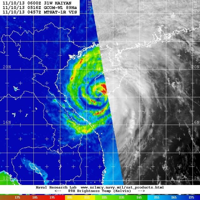
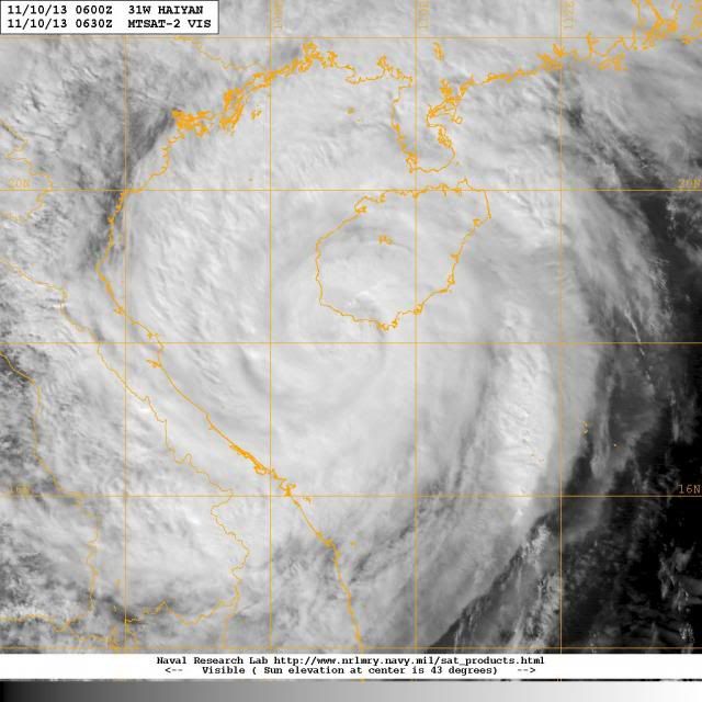
Ok I can see that. It was heading for western Hainan and has just wobbled slightly west. We can see that in the latest satellite images from the Navy website. On the first one you can see that the eye is coming on shore in western Hainan. In the second you can see that it wobbled west in the following one hour period. I would say if you smooth out the track locations from these two images that the eye is strafing the west coast of Hainan and is or will probably be onshore at times. And indeed, Alyono, it is taking the worst path possible wherever it can. Just bad news all around.

At 0516 UTC:
Image

At 0630 UTC:
Image
0 likes   

User avatar
mrbagyo
Category 5
Category 5
Posts: 3715
Age: 33
Joined: Thu Apr 12, 2012 9:18 am
Location: 14.13N 120.98E
Contact:

Re: WPAC: HAIYAN - Typhoon

#1385 Postby mrbagyo » Sun Nov 10, 2013 4:21 am

Because of Typhoon Haiyan - WPAC ACE is now up to 266.418 or 99% of the Normal ACE to date... and HAIYAN is still alive, still collecting some ACE points and we have 90W coming.
Haiyan also snatched the title of being the most energetic storm of 2013 from TY Francisco:
current ACE of TY Haiyan : 35.2725
ACE of TY Francisco : 34.6475

I wonder what's the lowest sea level pressure of HAIYAN
Typhoon Betty (1987) was able to attain a MSLP of 891 as confirmed by recon mission(recon ended in 1987, so Betty is one of those last storms to be penetrated by regular recon mission in WPAC) . Typhoon Betty was much smaller and more compact than Haiyan, had winds of 140 knots , and it happened in August , and there is also ridging to its north as stated in the 1987 JTWC ATCR. Typhoon Betty made landfall in Northern Samar as a borderline cat 4 or 5 , not extremely far north from the landfall site of Haiyan.

it's very possible that Haiyan does have a much lower pressure than Betty, maybe at 860-880mb level
0 likes   
The posts in this forum are NOT official forecast and should not be used as such. They are just the opinion of the poster and may or may not be backed by sound meteorological data. They are NOT endorsed by any professional institution or storm2k.org. For official information, please refer to RSMC, NHC and NWS products.

Alyono
Professional-Met
Professional-Met
Posts: 6961
Joined: Fri Apr 26, 2013 3:52 pm
Location: Texas Coast

#1386 Postby Alyono » Sun Nov 10, 2013 4:30 am

Photos from Guiuan

https://twitter.com/LorshO_o/status/399448839435726848
https://twitter.com/abraham_bormate/sta ... 3965167616
https://twitter.com/TyphoonHaiyan/statu ... 4838062081

the good news is... there are some survivors. Other than that... the photos speak for themselves
0 likes   

Alyono
Professional-Met
Professional-Met
Posts: 6961
Joined: Fri Apr 26, 2013 3:52 pm
Location: Texas Coast

#1387 Postby Alyono » Sun Nov 10, 2013 4:34 am

0 likes   

ozonepete
Professional-Met
Professional-Met
Posts: 4743
Joined: Mon Sep 07, 2009 3:23 pm
Location: From Ozone Park, NYC / Now in Brooklyn, NY

Re:

#1388 Postby ozonepete » Sun Nov 10, 2013 4:34 am

Alyono wrote:Photos from Guiuan

https://twitter.com/LorshO_o/status/399448839435726848
https://twitter.com/abraham_bormate/sta ... 3965167616
https://twitter.com/TyphoonHaiyan/statu ... 4838062081

the good news is... there are some survivors. Other than that... the photos speak for themselves


Thanks for posting. Just heart-breaking stuff. This damage could only have been caused by a cat 5. Virtually every tree has been blown down or snapped in half. The city looks like it's been smashed.
0 likes   

ozonepete
Professional-Met
Professional-Met
Posts: 4743
Joined: Mon Sep 07, 2009 3:23 pm
Location: From Ozone Park, NYC / Now in Brooklyn, NY

Re: WPAC: HAIYAN - Typhoon

#1389 Postby ozonepete » Sun Nov 10, 2013 5:13 am

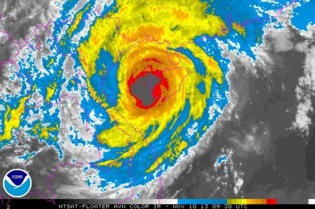
Boy, this storm just won't quit. The eye just skirted the western Hainan coast and that seems to have prevented it from weakening. Now that they eye is over the open water it looks like it's intensifying again.

Image
0 likes   

User avatar
somethingfunny
ChatStaff
ChatStaff
Posts: 3926
Age: 37
Joined: Thu May 31, 2007 10:30 pm
Location: McKinney, Texas

#1390 Postby somethingfunny » Sun Nov 10, 2013 6:02 am

This loop is really remarkable. I wonder if the typhoon's wind moving through the passes between the mountains of Hainan Island created temporary vorticies that attracted Typhoon Haiyan. Maybe the typhoon resumed its' northwestward course once the vorticies dissipated (different angle of wind as the storm gets closer?)

I know such phenomena have been observed or at least theorized in other cases.

Image

Image
0 likes   
I am not a meteorologist, and any posts made by me are not official forecasts or to be interpreted as being intelligent. These posts are just my opinions and are probably silly opinions.

User avatar
somethingfunny
ChatStaff
ChatStaff
Posts: 3926
Age: 37
Joined: Thu May 31, 2007 10:30 pm
Location: McKinney, Texas

Re: WPAC: HAIYAN - Typhoon

#1391 Postby somethingfunny » Sun Nov 10, 2013 6:13 am

cycloneye wrote:Ok folks.Prepare to read this first news from Guiuan.

2 Eastern Samar towns in ruins
by Rupert Ambil, posted on 11/10/2013 9:20 AM | Updated 11/10/2013 9:45 AM

CATBALOGAN CITY, Philippines - Giporlos and Guiuan in Eastern Samar are in ruins, with typhoon Yolanda damaging 95 percent of the two towns, according to eyewitness accounts on Sunday, November 10.

Because of the devastation, there are no clear estimates of casualties or survivors, they added.

Mark Biong, mayor of Giporlos, travelled 8 hours via a motorbike from his town to this city to report the devastation in Giporlos. In normal times, the road trip from Giporlos to Tacloban takes only one-and-half hours.

"It's total destruction," Biong told government officials and reporters here. At least 95% of the town has been damaged, he added. Giporlos is a coastal town, one of 22 municipalities of Eastern Samar. A 2010 census puts its population at 12,000.

Biong has no estimates of casualties or survivors.

The more remote town of Guiuan has also been flattened, leaving survivors helpless and triggering looting, according to Solar TV News reporter David Santos, who finally reached Tacloban City Sunday morning, November 9, after his communication lines were cut off for more than two days. He rode a motorbike

http://www.rappler.com/nation/43345-eas ... ns-yolanda


This catastrophe is beyond words for me. Awful, horrifying, apocalyptic, I can't find words to really express it.

Something that jumps out at me from the story of those two mayors riding motorbikes in (aside from happy surprise at the fact that both the mayor and a salvageable motorbike survived in Guiuan) is that they came to Tacloban on Day 3 without aid or communication from the outside world.
0 likes   
I am not a meteorologist, and any posts made by me are not official forecasts or to be interpreted as being intelligent. These posts are just my opinions and are probably silly opinions.

euro6208

Re: WPAC: HAIYAN - Typhoon

#1392 Postby euro6208 » Sun Nov 10, 2013 6:39 am

it's very possible that Haiyan does have a much lower pressure than Betty, maybe at 860-880mb level


Very likely the peak intensity is 180 knots with a central pressure of 850-860's. 840's could be a possibility.
0 likes   

User avatar
mrbagyo
Category 5
Category 5
Posts: 3715
Age: 33
Joined: Thu Apr 12, 2012 9:18 am
Location: 14.13N 120.98E
Contact:

Re: WPAC: HAIYAN - Typhoon

#1393 Postby mrbagyo » Sun Nov 10, 2013 7:34 am

this is PAGASA's weather station in GUIAN, SAMAR... looks like the globe containing the doppler radar at the top of the building didn't survive the brunt of HAIYAN... notice the vegetation surrounding of the station... it's wiped out!!!Image
0 likes   
The posts in this forum are NOT official forecast and should not be used as such. They are just the opinion of the poster and may or may not be backed by sound meteorological data. They are NOT endorsed by any professional institution or storm2k.org. For official information, please refer to RSMC, NHC and NWS products.

User avatar
xtyphooncyclonex
Category 5
Category 5
Posts: 3861
Age: 23
Joined: Sat Dec 08, 2012 9:07 am
Location: Cebu City
Contact:

#1394 Postby xtyphooncyclonex » Sun Nov 10, 2013 8:22 am

I hope our member, stormstrike, is fine after this storm and his family will recover quickly. And not only him, but all those affected over Cebu, Negros, Samar, Bohol, Biliran, Panay, Mindoro and Palawan.
Last edited by xtyphooncyclonex on Sun Nov 10, 2013 8:27 am, edited 1 time in total.
0 likes   
REMINDER: My opinions that I, or any other NON Pro-Met in this forum, are unofficial. Please do not take my opinions as an official forecast and warning. I am NOT a meteorologist. Following my forecasts blindly may lead to false alarm, danger and risk if official forecasts from agencies are ignored.

User avatar
xtyphooncyclonex
Category 5
Category 5
Posts: 3861
Age: 23
Joined: Sat Dec 08, 2012 9:07 am
Location: Cebu City
Contact:

#1395 Postby xtyphooncyclonex » Sun Nov 10, 2013 8:25 am

Our relatives' places in Ormoc and Tacloban are destroyed!!!! Pag-ampo palihug!!!!! Diri na maupay it nanghitabo ha Leyte ngan Samar tapos sa makusog ng bagyo!!!!

Pray for us.. I am almost in tears.
0 likes   
REMINDER: My opinions that I, or any other NON Pro-Met in this forum, are unofficial. Please do not take my opinions as an official forecast and warning. I am NOT a meteorologist. Following my forecasts blindly may lead to false alarm, danger and risk if official forecasts from agencies are ignored.

User avatar
cycloneye
Admin
Admin
Posts: 145308
Age: 68
Joined: Thu Oct 10, 2002 10:54 am
Location: San Juan, Puerto Rico

Re: WPAC: HAIYAN - Typhoon

#1396 Postby cycloneye » Sun Nov 10, 2013 8:31 am

There are no words to describe this scene from the air looking at Guiuan.

Image
0 likes   
Visit the Caribbean-Central America Weather Thread where you can find at first post web cams,radars
and observations from Caribbean basin members Click Here

User avatar
xtyphooncyclonex
Category 5
Category 5
Posts: 3861
Age: 23
Joined: Sat Dec 08, 2012 9:07 am
Location: Cebu City
Contact:

#1397 Postby xtyphooncyclonex » Sun Nov 10, 2013 8:38 am

If you guys want to know Yolanda's effects in Cebu City: http://www.youtube.com/watch?v=xKXODwI3gYc

Still not spared from typhoon-force winds and torrential rainfall.
0 likes   
REMINDER: My opinions that I, or any other NON Pro-Met in this forum, are unofficial. Please do not take my opinions as an official forecast and warning. I am NOT a meteorologist. Following my forecasts blindly may lead to false alarm, danger and risk if official forecasts from agencies are ignored.

User avatar
xtyphooncyclonex
Category 5
Category 5
Posts: 3861
Age: 23
Joined: Sat Dec 08, 2012 9:07 am
Location: Cebu City
Contact:

Re: WPAC: HAIYAN - Typhoon

#1398 Postby xtyphooncyclonex » Sun Nov 10, 2013 8:43 am

cycloneye wrote:There are no words to describe this scene from the air looking at Guiuan.

http://img268.imageshack.us/img268/8972/tkwr.jpg

I pray for those affected that they can have a fast, full recovery!

#BangonVisayas
#BangonLeyte
#BangonSamar
0 likes   
REMINDER: My opinions that I, or any other NON Pro-Met in this forum, are unofficial. Please do not take my opinions as an official forecast and warning. I am NOT a meteorologist. Following my forecasts blindly may lead to false alarm, danger and risk if official forecasts from agencies are ignored.

hurricanes1234
Category 5
Category 5
Posts: 2907
Joined: Sat Jul 28, 2012 6:19 pm
Location: Trinidad and Tobago

Re:

#1399 Postby hurricanes1234 » Sun Nov 10, 2013 8:46 am

xtyphooncyclonex wrote:Our relatives' places in Ormoc and Tacloban are destroyed!!!! Pag-ampo palihug!!!!! Diri na maupay it nanghitabo ha Leyte ngan Samar tapos sa makusog ng bagyo!!!!

Pray for us.. I am almost in tears.


I am extremely sorry to hear this. I can't express in much words how painful it must be to lose a loved one, and in this case, multiple. I will pray for you.
0 likes   
PLEASE NOTE: With the exception of information from weather agencies that I may copy and paste here, my posts will NEVER be official, since I am NOT a meteorologist. They are solely my amateur opinion, and may or may not be accurate. Therefore, please DO NOT use them as official details, particularly when making important decisions. Thank you.

User avatar
cycloneye
Admin
Admin
Posts: 145308
Age: 68
Joined: Thu Oct 10, 2002 10:54 am
Location: San Juan, Puerto Rico

Re: WPAC: HAIYAN - Typhoon

#1400 Postby cycloneye » Sun Nov 10, 2013 9:11 am

JTWC 15:00 UTC warning down to 75kts.

Image
0 likes   
Visit the Caribbean-Central America Weather Thread where you can find at first post web cams,radars
and observations from Caribbean basin members Click Here


Return to “2013”

Who is online

Users browsing this forum: No registered users and 7 guests