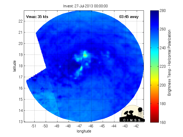
Increasing numbers for TS Dorian, back to 1.0.
DATE/TIME LAT LON CLASSIFICATION STORM
27/0545 UTC 18.1N 49.0W T1.0/1.0 DORIAN
26/2345 UTC 17.9N 47.1W TOO WEAK DORIAN
ATL: DORIAN - Post-Tropical - Discussion
Moderator: S2k Moderators
-
Gustywind

- Category 5

- Posts: 12334
- Joined: Mon Sep 03, 2007 7:29 am
- Location: Baie-Mahault, GUADELOUPE
Maintaining its TS status....
000
WTNT34 KNHC 270832
TCPAT4
BULLETIN
TROPICAL STORM DORIAN ADVISORY NUMBER 13
NWS NATIONAL HURRICANE CENTER MIAMI FL AL042013
500 AM AST SAT JUL 27 2013
...DORIAN CONTINUES MOVING RAPIDLY WESTWARD AS A TROPICAL STORM...
SUMMARY OF 500 AM AST...0900 UTC...INFORMATION
----------------------------------------------
LOCATION...18.2N 50.0W
ABOUT 860 MI...1385 KM E OF THE NORTHERN LEEWARD ISLANDS
MAXIMUM SUSTAINED WINDS...40 MPH...65 KM/H
PRESENT MOVEMENT...W OR 275 DEGREES AT 22 MPH...35 KM/H
MINIMUM CENTRAL PRESSURE...1011 MB...29.85 INCHES
0 likes
-
Hurricane Alexis

- Category 2

- Posts: 683
- Age: 29
- Joined: Thu Jun 14, 2012 7:59 pm
- Location: Miami,Florida
Trough is backing to the west. Maybe it can survive after all.
Personal Forecast Disclaimer:
The posts in this forum are NOT official forecast and should not be used as such. They are just the opinion of the poster and may or may not be backed by sound meteorological data. They are NOT endorsed by any professional institution or storm2k.org. For official information, please refer to the NHC and NWS products.
0 likes
Personal Forecast Disclaimer:
The posts in this forum are NOT official forecast and should not be used as such. They are just the opinion of the poster and may or may not be backed by sound meteorological data. They are NOT endorsed by any professional institution or storm2k.org. For official information, please refer to the NHC and NWS products.
The posts in this forum are NOT official forecast and should not be used as such. They are just the opinion of the poster and may or may not be backed by sound meteorological data. They are NOT endorsed by any professional institution or storm2k.org. For official information, please refer to the NHC and NWS products.

Re:
Gustywind wrote:Maintaining its TS status....
000
WTNT34 KNHC 270832
TCPAT4
BULLETIN
TROPICAL STORM DORIAN ADVISORY NUMBER 13
NWS NATIONAL HURRICANE CENTER MIAMI FL AL042013
500 AM AST SAT JUL 27 2013
...DORIAN CONTINUES MOVING RAPIDLY WESTWARD AS A TROPICAL STORM...
.
SUMMARY OF 500 AM AST...0900 UTC...INFORMATION
----------------------------------------------
LOCATION...18.2N 50.0W
ABOUT 860 MI...1385 KM E OF THE NORTHERN LEEWARD ISLANDS
MAXIMUM SUSTAINED WINDS...40 MPH...65 KM/H
PRESENT MOVEMENT...W OR 275 DEGREES AT 22 MPH...35 KM/H
MINIMUM CENTRAL PRESSURE...1011 MB...29.85 INCHES
IMO, it has slow down some during the night, I estimate it to be near 20 mph if not a little lower.
0 likes
Re: ATL: DORIAN - Tropical Storm - Discussion
I place the X on the COC I have been tracking all night long, near 18.5N & 50.8W.

0 likes
-
tolakram
- Admin

- Posts: 20186
- Age: 62
- Joined: Sun Aug 27, 2006 8:23 pm
- Location: Florence, KY (name is Mark)
Re: ATL: DORIAN - Tropical Storm - Discussion
Live visible loop: http://wwwghcc.msfc.nasa.gov/cgi-bin/ge ... 5&map=none
0 likes
M a r k
- - - - -
Join us in chat: Storm2K Chatroom Invite. Android and IOS apps also available.
The posts in this forum are NOT official forecasts and should not be used as such. Posts are NOT endorsed by any professional institution or STORM2K.org. For official information and forecasts, please refer to NHC and NWS products.
-
tolakram
- Admin
- Posts: 20186
- Age: 62
- Joined: Sun Aug 27, 2006 8:23 pm
- Location: Florence, KY (name is Mark)
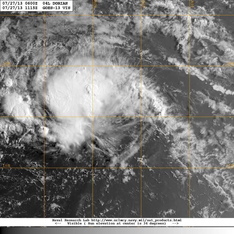
Re: ATL: DORIAN - Tropical Storm - Discussion
11:15z

0 likes
M a r k
- - - - -
Join us in chat: Storm2K Chatroom Invite. Android and IOS apps also available.
The posts in this forum are NOT official forecasts and should not be used as such. Posts are NOT endorsed by any professional institution or STORM2K.org. For official information and forecasts, please refer to NHC and NWS products.
- - - - -
Join us in chat: Storm2K Chatroom Invite. Android and IOS apps also available.
The posts in this forum are NOT official forecasts and should not be used as such. Posts are NOT endorsed by any professional institution or STORM2K.org. For official information and forecasts, please refer to NHC and NWS products.
-
tolakram
- Admin
- Posts: 20186
- Age: 62
- Joined: Sun Aug 27, 2006 8:23 pm
- Location: Florence, KY (name is Mark)
Re: ATL: DORIAN - Models
0z Euro takes a tropical wave Dorian to the Keys, then lifts up over Florida, exiting NE Florida coast. Looks like a rain maker.
This is a very similar solution to the 6Z GFS, looking at pressure and precip rate.
This is a very similar solution to the 6Z GFS, looking at pressure and precip rate.
0 likes
M a r k
- - - - -
Join us in chat: Storm2K Chatroom Invite. Android and IOS apps also available.
The posts in this forum are NOT official forecasts and should not be used as such. Posts are NOT endorsed by any professional institution or STORM2K.org. For official information and forecasts, please refer to NHC and NWS products.
- - - - -
Join us in chat: Storm2K Chatroom Invite. Android and IOS apps also available.
The posts in this forum are NOT official forecasts and should not be used as such. Posts are NOT endorsed by any professional institution or STORM2K.org. For official information and forecasts, please refer to NHC and NWS products.
-
Weatherboy1

- Category 5
- Posts: 1190
- Age: 50
- Joined: Mon Jul 05, 2004 1:50 pm
- Location: Jupiter/Sarasota, FL


-
cycloneye

- Admin
- Posts: 149498
- Age: 69
- Joined: Thu Oct 10, 2002 10:54 am
- Location: San Juan, Puerto Rico
Re: ATL: DORIAN - Tropical Storm - Discussion
12z Best Track.
AL, 04, 2013072712, , BEST, 0, 183N, 511W, 35, 1011, TS
AL, 04, 2013072712, , BEST, 0, 183N, 511W, 35, 1011, TS
0 likes
Visit the Caribbean-Central America Weather Thread where you can find at first post web cams,radars
and observations from Caribbean basin members Click Here
and observations from Caribbean basin members Click Here
-
weatherwindow

- Category 4

- Posts: 904
- Joined: Mon Sep 20, 2004 9:48 am
- Location: key west/ft lauderdale
Re: Re:
SFLcane wrote:northjaxpro wrote:Well, that TUTT was forecast to weaken and retrograde westward a couple of days ago. If that is beginning to take place now, then conditions ahead of the cyclone are really going to begin to become increasingly conducive. But, is all of this happening too late fr Dorian now? We will know this weekend.
That about sums it up
From the NWS San Juan 0513AST 7/27
"The dominant feature is a TUTT and associated low which sags south thru our area and into the east central Caribbean. The TUTT will continue to retrogress westward during the next few days as an upper ridge builds in from the east and set up across the northeast Caribbean"
http://forecast.weather.gov/product.php ... glossary=1
It would appear that at least this source of shear facing Dorian will lessen considerably over the next few days. Perhaps, this will give Dorian a new lease on life...Grtz from KW, Rich
0 likes
-
ConvergenceZone
.gif)
- Category 5
- Posts: 5241
- Joined: Fri Jul 29, 2005 1:40 am
- Location: Northern California
Re:
Weatherboy1 wrote:Well this is one heck of a recovery for Dorian no? I went to bed when he was hardly a naked swirl and now he's looking healthier than in a while. Shear will be an issue soon. But maybe he can hold together after all. We will see!
Well, the NHC would disagree with you. Even in their last data they suggest that Dorian may no longer even have a closed circulation, and that the convection may be short lived. So this may be downgraded sooner than you think....
0 likes
-
northjaxpro

- S2K Supporter

- Posts: 8900
- Joined: Mon Sep 27, 2010 11:21 am
- Location: Jacksonville, FL
Dorian is holding its own so far this morning. The convective burst during the past 6-8 hours has really helped to keep Dorian stay alive for now. The next 36 hours are going to be absolutely critical for Dorian. There is a shear axis just ahead of the system and somehow Dorian is going to have to find a way to get through it. However, the TUTT is finally beginning to weaken and retrograde westward. I think that if Dorian can survive the next 36 hours or so and reach 60 degrees Longitude, the cyclone will find itself in an improving, more hospitable environment. Shear should be decreasing by that time and moisture content around Dorian will be markedly improved.
Dorian is still in critical condition for this weekend, but there is a chance by the end of this weekend that the system may have a resurgance early next week. Again, this weekend will tell the story one way or the other for sure.i
Dorian is still in critical condition for this weekend, but there is a chance by the end of this weekend that the system may have a resurgance early next week. Again, this weekend will tell the story one way or the other for sure.i
0 likes
NEVER, EVER SAY NEVER in the tropics and weather in general, and most importantly, with life itself!!
________________________________________________________________________________________
Fay 2008 Beryl 2012 Debby 2012 Colin 2016 Hermine 2016 Julia 2016 Matthew 2016 Irma 2017 Dorian 2019
________________________________________________________________________________________
Fay 2008 Beryl 2012 Debby 2012 Colin 2016 Hermine 2016 Julia 2016 Matthew 2016 Irma 2017 Dorian 2019
The reason why the GFS keeps wanting to dissipate Dorian down to barely a water vapor is because it keeps forecasting Dorian to catch up to the UL trough and go underneath the UL trough killing whatever vorticity is left by then.
On the other hand, the ECMWF keeps showing for the UL trough to slowly push south and west and die out some showing better UL conditions north of Hispaniola and the eastern Bahamas than the GFS.
I guess we will see who is right.
On the other hand, the ECMWF keeps showing for the UL trough to slowly push south and west and die out some showing better UL conditions north of Hispaniola and the eastern Bahamas than the GFS.
I guess we will see who is right.
0 likes
Who is online
Users browsing this forum: No registered users and 41 guests