Based on this wording from the NHC: DORIAN CONTINUES MOVING RAPIDLY WESTWARD AS A TROPICAL STORM...
Their thinking must be that it will catch up to the TUTT and get killed off. Lotta struggles ahead. Wait and see....
ATL: DORIAN - Post-Tropical - Discussion
Moderator: S2k Moderators

-
tolakram
- Admin

- Posts: 20186
- Age: 62
- Joined: Sun Aug 27, 2006 8:23 pm
- Location: Florence, KY (name is Mark)
Re: ATL: DORIAN - Tropical Storm - Discussion
Center appears to be visible between cloud masses.

live loop: http://wwwghcc.msfc.nasa.gov/cgi-bin/ge ... umframes=5
live loop: http://wwwghcc.msfc.nasa.gov/cgi-bin/ge ... umframes=5
0 likes
M a r k
- - - - -
Join us in chat: Storm2K Chatroom Invite. Android and IOS apps also available.
The posts in this forum are NOT official forecasts and should not be used as such. Posts are NOT endorsed by any professional institution or STORM2K.org. For official information and forecasts, please refer to NHC and NWS products.

Re:
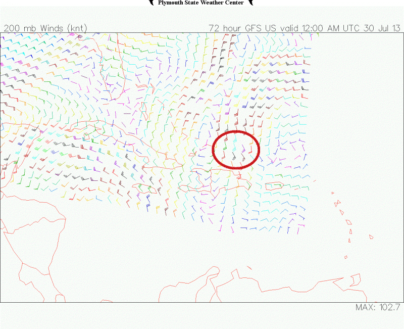
NDG wrote:The reason why the GFS keeps wanting to dissipate Dorian down to barely a water vapor is because it keeps forecasting Dorian to catch up to the UL trough and go underneath the UL trough killing whatever vorticity is left by then.
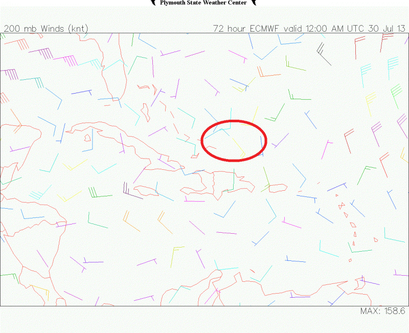
On the other hand, the ECMWF keeps showing for the UL trough to slowly push south and west and die out some showing better UL conditions north of Hispaniola and the eastern Bahamas than the GFS.
I guess we will see who is right.
This is what I am talking about:
GFS for Monday night, circled area is where Dorian's vorticity is forecasted to be in relation to the UL trough:
ECMWF forecast for Monday night, circled area is where Dorian's vorticity is forecasted to be in relation to the UL trough, as you can it paints a better picture for Dorian than the GFS.
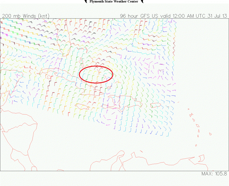
GFS forecast for Tuesday night, it basically does not move the UL trough/TUTT during the day Tuesday.
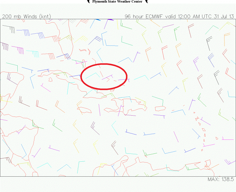
ECMWF forecast for Tuesday night.
0 likes
-
Blown Away

- S2K Supporter

- Posts: 10253
- Joined: Wed May 26, 2004 6:17 am
Re: ATL: DORIAN - Models
Is there any model that shows anything but Dorian as a wave or weak TS? Impressed with model agreement over the past few days.
0 likes
Hurricane Eye Experience: David 79, Irene 99, Frances 04, Jeanne 04, Wilma 05… Hurricane Brush Experience: Andrew 92, Erin 95, Floyd 99, Matthew 16, Irma 17, Ian 22, Nicole 22…
-
SFLcane

- S2K Supporter
- Posts: 10281
- Age: 48
- Joined: Sat Jun 05, 2010 1:44 pm
- Location: Lake Worth Florida
Re: ATL: DORIAN - Tropical Storm - Discussion
whatever weak disorganized convection dorian has should eventually weaken further as it continues moving into the stable airmass along with increasing wind shear.
0 likes
-
tolakram
- Admin
- Posts: 20186
- Age: 62
- Joined: Sun Aug 27, 2006 8:23 pm
- Location: Florence, KY (name is Mark)
Re: ATL: DORIAN - Tropical Storm - Discussion
0 likes
M a r k
- - - - -
Join us in chat: Storm2K Chatroom Invite. Android and IOS apps also available.
The posts in this forum are NOT official forecasts and should not be used as such. Posts are NOT endorsed by any professional institution or STORM2K.org. For official information and forecasts, please refer to NHC and NWS products.
- - - - -
Join us in chat: Storm2K Chatroom Invite. Android and IOS apps also available.
The posts in this forum are NOT official forecasts and should not be used as such. Posts are NOT endorsed by any professional institution or STORM2K.org. For official information and forecasts, please refer to NHC and NWS products.
The dry air in the mid levels is what looks like is still going to be a bad player for its survival.
SHEAR (KT) 13 12 14 14 11 11 17 11 16 9 18 10 17
700-500 MB RH 43 40 39 39 40 39 40 39 38 41 42 48 50
Last edited by NDG on Sat Jul 27, 2013 8:44 am, edited 1 time in total.
0 likes
Re: ATL: DORIAN - Tropical Storm - Discussion
tolakram wrote:MIMIC-TPW actually looks a little better.
http://tropic.ssec.wisc.edu/real-time/m ... /main.html
Notice that it still has a nice vorticity, if it can fight the dry air in the mid levels perhaps a stronger LLC could develop.
0 likes
-
tolakram
- Admin
- Posts: 20186
- Age: 62
- Joined: Sun Aug 27, 2006 8:23 pm
- Location: Florence, KY (name is Mark)
Re: ATL: DORIAN - Tropical Storm - Discussion
0 likes
M a r k
- - - - -
Join us in chat: Storm2K Chatroom Invite. Android and IOS apps also available.
The posts in this forum are NOT official forecasts and should not be used as such. Posts are NOT endorsed by any professional institution or STORM2K.org. For official information and forecasts, please refer to NHC and NWS products.
- - - - -
Join us in chat: Storm2K Chatroom Invite. Android and IOS apps also available.
The posts in this forum are NOT official forecasts and should not be used as such. Posts are NOT endorsed by any professional institution or STORM2K.org. For official information and forecasts, please refer to NHC and NWS products.

-
northjaxpro

- S2K Supporter
- Posts: 8900
- Joined: Mon Sep 27, 2010 11:21 am
- Location: Jacksonville, FL
0 likes
NEVER, EVER SAY NEVER in the tropics and weather in general, and most importantly, with life itself!!
________________________________________________________________________________________
Fay 2008 Beryl 2012 Debby 2012 Colin 2016 Hermine 2016 Julia 2016 Matthew 2016 Irma 2017 Dorian 2019
________________________________________________________________________________________
Fay 2008 Beryl 2012 Debby 2012 Colin 2016 Hermine 2016 Julia 2016 Matthew 2016 Irma 2017 Dorian 2019
-
tolakram
- Admin
- Posts: 20186
- Age: 62
- Joined: Sun Aug 27, 2006 8:23 pm
- Location: Florence, KY (name is Mark)
Re: ATL: DORIAN - Tropical Storm - Discussion
Live WV loop: http://wwwghcc.msfc.nasa.gov/cgi-bin/ge ... mframes=10
0 likes
M a r k
- - - - -
Join us in chat: Storm2K Chatroom Invite. Android and IOS apps also available.
The posts in this forum are NOT official forecasts and should not be used as such. Posts are NOT endorsed by any professional institution or STORM2K.org. For official information and forecasts, please refer to NHC and NWS products.
- - - - -
Join us in chat: Storm2K Chatroom Invite. Android and IOS apps also available.
The posts in this forum are NOT official forecasts and should not be used as such. Posts are NOT endorsed by any professional institution or STORM2K.org. For official information and forecasts, please refer to NHC and NWS products.

Re: ATL: DORIAN - Tropical Storm - Discussion
Forward speed is it's biggest problem for the next two days IMHO.
Shear 3hrs ago
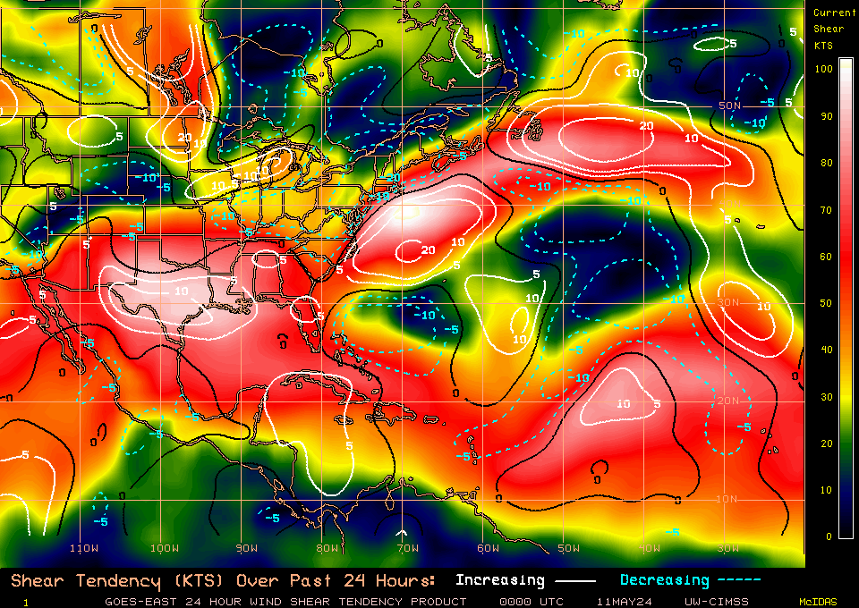
now

mid level shear now

It's in the stablest air it's going to be in for a while, should improve tomorrow and SST will rise a little more. D-min in 5 or 6 hrs then it should intestify to much healthier TS, is my very unprofessional forecast for Sunday evening.
Shear 3hrs ago
now
mid level shear now
It's in the stablest air it's going to be in for a while, should improve tomorrow and SST will rise a little more. D-min in 5 or 6 hrs then it should intestify to much healthier TS, is my very unprofessional forecast for Sunday evening.
0 likes
The following post is NOT an official forecast and should not be used as such. It is just the opinion of the poster and may or may not be backed by sound meteorological data. It is NOT endorsed by any professional institution including storm2k.org For Official Information please refer to the NHC and NWS products.
Re: ATL: DORIAN - Tropical Storm - Discussion
tolakram wrote:Live WV loop: http://wwwghcc.msfc.nasa.gov/cgi-bin/ge ... mframes=10
I like those colors, reminds me of LSU and Party Gras
0 likes
The following post is NOT an official forecast and should not be used as such. It is just the opinion of the poster and may or may not be backed by sound meteorological data. It is NOT endorsed by any professional institution including storm2k.org For Official Information please refer to the NHC and NWS products.

Re: ATL: DORIAN - Tropical Storm - Discussion
All dried up again. DMAX can't get there soon enough for Dorian.
http://rammb.cira.colostate.edu/ramsdis ... height=480
http://rammb.cira.colostate.edu/ramsdis ... height=480
0 likes

I am almost starting to think that the MDR is going to be close for business this season as well, if this stable air keeps dominating it like it has so far this season and the last few seasons.
A storm would have to track far south like Chantal did or gain some more latitude towards the NW Atlantic to get away from the sea dessert.
A storm would have to track far south like Chantal did or gain some more latitude towards the NW Atlantic to get away from the sea dessert.
0 likes
-
cycloneye

- Admin
- Posts: 149498
- Age: 69
- Joined: Thu Oct 10, 2002 10:54 am
- Location: San Juan, Puerto Rico
Re: ATL: DORIAN - Advisories
BULLETIN
TROPICAL STORM DORIAN ADVISORY NUMBER 14
NWS NATIONAL HURRICANE CENTER MIAMI FL AL042013
1100 AM AST SAT JUL 27 2013
...DORIAN STILL MOVING RAPIDLY WESTWARD...
SUMMARY OF 1100 AM AST...1500 UTC...INFORMATION
-----------------------------------------------
LOCATION...18.5N 52.1W
ABOUT 720 MI...1160 KM E OF THE NORTHERN LEEWARD ISLANDS
MAXIMUM SUSTAINED WINDS...40 MPH...65 KM/H
PRESENT MOVEMENT...W OR 280 DEGREES AT 23 MPH...37 KM/H
MINIMUM CENTRAL PRESSURE...1011 MB...29.85 INCHES
WATCHES AND WARNINGS
--------------------
THERE ARE NO COASTAL WATCHES OR WARNINGS IN EFFECT.
INTERESTS IN THE NORTHERN LEEWARD ISLANDS...THE VIRGIN ISLANDS...AND
PUERTO RICO SHOULD MONITOR THE PROGRESS OF DORIAN.
DISCUSSION AND 48-HOUR OUTLOOK
------------------------------
AT 1100 AM AST...1500 UTC...THE CENTER OF TROPICAL STORM DORIAN WAS
LOCATED NEAR LATITUDE 18.5 NORTH...LONGITUDE 52.1 WEST. DORIAN IS
MOVING TOWARD THE WEST NEAR 23 MPH...37 KM/H...AND THIS GENERAL
MOTION IS EXPECTED TO CONTINUE DURING THE NEXT TWO DAYS.
MAXIMUM SUSTAINED WINDS ARE NEAR 40 MPH...65 KM/H...WITH HIGHER
GUSTS. DORIAN IS EXPECTED TO WEAKEN AND BECOME A REMNANT LOW IN A
DAY OR SO.
TROPICAL STORM FORCE WINDS EXTEND OUTWARD UP TO 60 MILES...95 KM
FROM THE CENTER.
THE ESTIMATED MINIMUM CENTRAL PRESSURE IS 1011 MB...29.85 INCHES.
HAZARDS AFFECTING LAND
----------------------
NONE.
NEXT ADVISORY
-------------
NEXT COMPLETE ADVISORY...500 PM AST.
$$
FORECASTER PASCH
TROPICAL STORM DORIAN DISCUSSION NUMBER 14
NWS NATIONAL HURRICANE CENTER MIAMI FL AL042013
1100 AM AST SAT JUL 27 2013
DORIAN HAS A VERY DISORGANIZED SATELLITE PRESENTATION...WITH DEEP
CONVECTION LIMITED TO A FEW CLUSTERS AND NO EVIDENCE OF BANDING.
THE CURRENT INTENSITY IS HELD AT 35 KT IN ACCORDANCE WITH A DVORAK
ESTIMATE FROM TAFB. THE CYCLONE CONTINUES TO INTERACT WITH A DRY
AIR MASS...AND SOUTHWESTERLY SHEAR ASSOCIATED WITH A LARGE
UPPER-LEVEL TROUGH TO THE WEST OF DORIAN SHOULD BEGIN TO AFFECT THE
SYSTEM SOON. GIVEN THE HOSTILE ENVIRONMENT...THE SYSTEM SHOULD
WEAKEN TO A REMNANT LOW IN A DAY OR SO. ALTERNATIVELY...SINCE
SCATTEROMETER DATA SUGGEST THAT THE CIRCULATION IS BARELY CLOSED...
DORIAN COULD OPEN UP INTO A WAVE AT ANY TIME.
THE SYSTEM IS EMBEDDED WITHIN STRONG LOW- TO MID-LEVEL EASTERLY FLOW
AND CONTINUES TO MOVE RAPIDLY WESTWARD...OR 280/20. THERE ARE NO
SIGNIFICANT CHANGES TO THE TRACK FORECAST OR FORECAST REASONING. A
MID- TO LOW-LEVEL RIDGE IS PREDICTED BY THE GLOBAL MODELS TO BUILD
WESTWARD OVER THE NEXT COUPLE OF DAYS AND THIS SHOULD MAINTAIN A
MOSTLY WESTWARD MOTION UNTIL DISSIPATION. THE OFFICIAL TRACK IS
ESSENTIALLY AN UPDATE OF THE PREVIOUS ONE AND IS ABOUT IN THE
MIDDLE OF THE GUIDANCE ENVELOPE.
GIVEN THE TRACK AND INTENSITY FORECAST...ALONG WITH THE WEAK WIND
FIELD OVER THE SOUTHERN SEMICIRCLE OF THE CYCLONE...WATCHES OR
WARNINGS ARE NOT NEEDED FOR THE ISLANDS OF THE NORTHEAST CARIBBEAN.
FORECAST POSITIONS AND MAX WINDS
INIT 27/1500Z 18.5N 52.1W 35 KT 40 MPH
12H 28/0000Z 18.9N 55.3W 30 KT 35 MPH
24H 28/1200Z 19.5N 59.4W 30 KT 35 MPH
36H 29/0000Z 20.2N 63.3W 25 KT 30 MPH...POST-TROP/REMNT LOW
48H 29/1200Z 20.7N 66.7W 25 KT 30 MPH...POST-TROP/REMNT LOW
72H 30/1200Z 21.5N 73.5W 25 KT 30 MPH...POST-TROP/REMNT LOW
96H 31/1200Z...DISSIPATED
$$
FORECASTER PASCH
0 likes
Visit the Caribbean-Central America Weather Thread where you can find at first post web cams,radars
and observations from Caribbean basin members Click Here
and observations from Caribbean basin members Click Here
-
SFLcane
- S2K Supporter
- Posts: 10281
- Age: 48
- Joined: Sat Jun 05, 2010 1:44 pm
- Location: Lake Worth Florida
Re: ATL: DORIAN - Tropical Storm - Discussion
NHC 11am..
DORIAN HAS A VERY DISORGANIZED SATELLITE PRESENTATION...WITH DEEP
CONVECTION LIMITED TO A FEW CLUSTERS AND NO EVIDENCE OF BANDING.
THE CURRENT INTENSITY IS HELD AT 35 KT IN ACCORDANCE WITH A DVORAK
ESTIMATE FROM TAFB. THE CYCLONE CONTINUES TO INTERACT WITH A DRY
AIR MASS...AND SOUTHWESTERLY SHEAR ASSOCIATED WITH A LARGE
UPPER-LEVEL TROUGH TO THE WEST OF DORIAN SHOULD BEGIN TO AFFECT THE
SYSTEM SOON. GIVEN THE HOSTILE ENVIRONMENT...THE SYSTEM SHOULD
WEAKEN TO A REMNANT LOW IN A DAY OR SO. ALTERNATIVELY...SINCE
SCATTEROMETER DATA SUGGEST THAT THE CIRCULATION IS BARELY CLOSED...
DORIAN COULD OPEN UP INTO A WAVE AT ANY TIME.
0 likes
Who is online
Users browsing this forum: No registered users and 41 guests