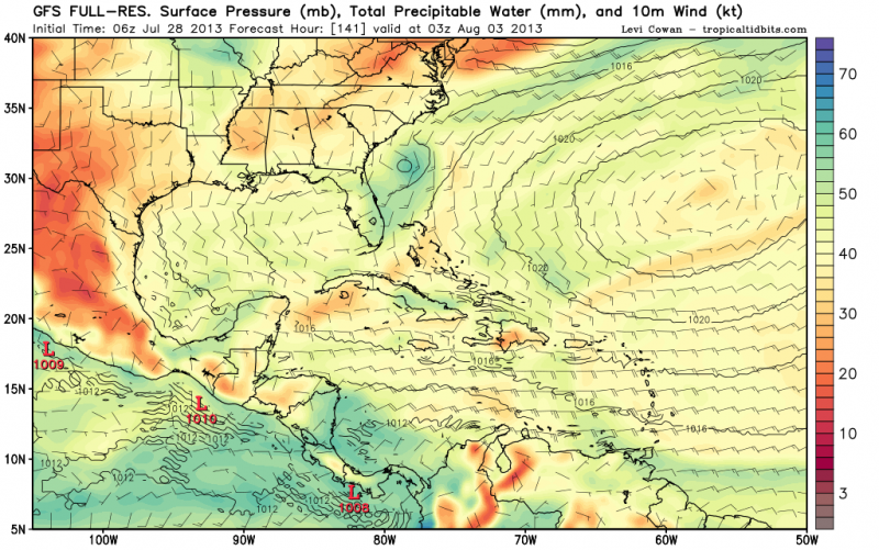
Interesting that UKMET spins up "a new storm" in the eastern Gulf on Thursday. Looking at the actual graphical guidance of the UKMET clearly shows that this is still Dorian:
NEW TROPICAL STORM FORECAST TO DEVELOP AFTER 108 HOURS
FORECAST POSITION AT T+108 : 24.1N 81.2W
VERIFYING TIME POSITION STRENGTH TENDENCY
-------------- -------- -------- --------
12UTC 01.08.2013 24.1N 81.2W WEAK
00UTC 02.08.2013 25.1N 82.7W WEAK LITTLE CHANGE
12UTC 02.08.2013 26.6N 83.5W WEAK LITTLE CHANGE
00UTC 03.08.2013 27.4N 84.2W MODERATE LITTLE CHANGE
ATL: DORIAN - Post-Tropical - Discussion
Moderator: S2k Moderators
-
crownweather

- S2K Supporter

- Posts: 602
- Age: 51
- Joined: Sat Aug 12, 2006 9:21 am
- Location: Sturbridge, Massachusetts
- Contact:

Re: ATL: DORIAN - Remnants - Discussion
Who said Dorian is dead?
Shear is inducing a ton of overshooting tops not to mention a rapidly developing UL outflow.
http://www.ssd.noaa.gov/PS/TROP/floater ... -long.html
http://www.ssd.noaa.gov/PS/TROP/floater ... -long.html
Watching to see what happens when it gets into the lower shear environment.
Shear is inducing a ton of overshooting tops not to mention a rapidly developing UL outflow.
http://www.ssd.noaa.gov/PS/TROP/floater ... -long.html
http://www.ssd.noaa.gov/PS/TROP/floater ... -long.html
Watching to see what happens when it gets into the lower shear environment.
0 likes
Re: ATL: DORIAN - Remnants - Discussion
Pretty darn good rain rate.
http://www.nrlmry.navy.mil/htdocs_dyn_p ... W.59pc.jpg
Could kick some of the shear out of the way.
This could effectively raise the tropopause height near the LLC and move the anti-cyclone back in.
http://www.nrlmry.navy.mil/htdocs_dyn_p ... W.59pc.jpg
Could kick some of the shear out of the way.
This could effectively raise the tropopause height near the LLC and move the anti-cyclone back in.
0 likes
-
cycloneye

- Admin

- Posts: 149495
- Age: 69
- Joined: Thu Oct 10, 2002 10:54 am
- Location: San Juan, Puerto Rico
Re: ATL: DORIAN - Remnants - Discussion
Up to 20%
Recon going this afternoon!
A TROUGH OF LOW PRESSURE...ASSOCIATED WITH THE REMNANTS OF DORIAN...
IS PRODUCING AN AREA OF SHOWERS AND THUNDERSTORMS THAT EXTENDS A
FEW HUNDRED MILES NORTHEAST OF THE NORTHERN LEEWARD ISLANDS. THIS
ACTIVITY IS FORECAST TO MOVE WESTWARD AT 15 TO 20 MPH DURING THE
NEXT COUPLE OF DAYS...PASSING NORTH OF THE LEEWARD ISLANDS AND
PUERTO RICO TODAY AND MONDAY...AND MOVING OVER THE TURKS AND CAICOS
ISLANDS AND SOUTHERN BAHAMAS BY EARLY TUESDAY. ENVIRONMENTAL
CONDITIONS ARE ONLY MARGINALLY CONDUCIVE FOR REGENERATION...AND
THIS SYSTEM HAS A LOW CHANCE...20 PERCENT...OF BECOMING A TROPICAL
CYCLONE DURING THE NEXT 48 HOURS. AN AIR FORCE PLANE IS SCHEDULED
TO INVESTIGATE THIS DISTURBANCE LATER TODAY.
0 likes
Visit the Caribbean-Central America Weather Thread where you can find at first post web cams,radars
and observations from Caribbean basin members Click Here
and observations from Caribbean basin members Click Here
-
jlauderdal
- S2K Supporter
- Posts: 7240
- Joined: Wed May 19, 2004 5:46 am
- Location: NE Fort Lauderdale
- Contact:
Re: ATL: DORIAN - Remnants - Discussion
cycloneye wrote:Up to 20%
Recon going this afternoon!
A TROUGH OF LOW PRESSURE...ASSOCIATED WITH THE REMNANTS OF DORIAN...
IS PRODUCING AN AREA OF SHOWERS AND THUNDERSTORMS THAT EXTENDS A
FEW HUNDRED MILES NORTHEAST OF THE NORTHERN LEEWARD ISLANDS. THIS
ACTIVITY IS FORECAST TO MOVE WESTWARD AT 15 TO 20 MPH DURING THE
NEXT COUPLE OF DAYS...PASSING NORTH OF THE LEEWARD ISLANDS AND
PUERTO RICO TODAY AND MONDAY...AND MOVING OVER THE TURKS AND CAICOS
ISLANDS AND SOUTHERN BAHAMAS BY EARLY TUESDAY. ENVIRONMENTAL
CONDITIONS ARE ONLY MARGINALLY CONDUCIVE FOR REGENERATION...AND
THIS SYSTEM HAS A LOW CHANCE...20 PERCENT...OF BECOMING A TROPICAL
CYCLONE DURING THE NEXT 48 HOURS. AN AIR FORCE PLANE IS SCHEDULED
TO INVESTIGATE THIS DISTURBANCE LATER TODAY.
when is the squadron leaving?
0 likes
-
cycloneye
- Admin
- Posts: 149495
- Age: 69
- Joined: Thu Oct 10, 2002 10:54 am
- Location: San Juan, Puerto Rico
Re: ATL: INVEST 91L - Dorian Remnants - Discussion
Is now 91L.
BEGIN
NHC_ATCF
invest_RENUMBER_al042013_al912013.ren
FSTDA
R
U
040
010
0000
201307281201
NONE
NOTIFY=ATRP
BEGIN
NHC_ATCF
invest_RENUMBER_al042013_al912013.ren
FSTDA
R
U
040
010
0000
201307281201
NONE
NOTIFY=ATRP
0 likes
Visit the Caribbean-Central America Weather Thread where you can find at first post web cams,radars
and observations from Caribbean basin members Click Here
and observations from Caribbean basin members Click Here
-
cycloneye
- Admin
- Posts: 149495
- Age: 69
- Joined: Thu Oct 10, 2002 10:54 am
- Location: San Juan, Puerto Rico
Re: ATL: INVEST 91L - Dorian Remnants - Discussion
0 likes
Visit the Caribbean-Central America Weather Thread where you can find at first post web cams,radars
and observations from Caribbean basin members Click Here
and observations from Caribbean basin members Click Here

Re: ATL: DORIAN - Remnants - Discussion
I think the UL trough has really helped to refire the remnants of Dorian with UL divergence.
It still has a nice vorticity. The problem will be how it interacts with the UL low as it catched up to it, will the UL trough weaken like the Euro was showing a few days ago, I guess that is the big question.
This morning's 06z GFS shows a run similar to the Euro of the vorticity reaching eastern FL and then getting picked up by the next trough and as it gets back over the Gulf Stream for it start really developing as it passes to east the Carolinas and out to sea.
0 likes
Re: ATL: INVEST 91L - Dorian Remnants - Discussion
This is going to be a battle with the ULL at 23N 70W.
http://tropic.ssec.wisc.edu/real-time/a ... g8wvir.GIF
Key is 200mb PV and if it breaks down ahead of Dorian.
http://tropic.ssec.wisc.edu/real-time/a ... g8vor1.GIF
Hot towers always do the trick.
http://tropic.ssec.wisc.edu/real-time/a ... g8wvir.GIF
Key is 200mb PV and if it breaks down ahead of Dorian.
http://tropic.ssec.wisc.edu/real-time/a ... g8vor1.GIF
Hot towers always do the trick.
0 likes
Re: ATL: INVEST 91L - Dorian Remnants - Discussion
cycloneye wrote:Is now 91L.
BEGIN
NHC_ATCF
invest_RENUMBER_al042013_al912013.ren
FSTDA
R
U
040
010
0000
201307281201
NONE
NOTIFY=ATRP
Good, I guess we will 12z models coming out soon, it will be interesting what SHIPS shows for as far as shear over the system for the next few days.
0 likes
Re: ATL: INVEST 91L - Dorian Remnants - Discussion
Good looking cell developing on the microwave loop
http://tropic.ssec.wisc.edu/real-time/m ... splay.html
http://tropic.ssec.wisc.edu/real-time/m ... splay.html
0 likes
Re: ATL: INVEST 91L - Dorian Remnants - Discussion
AMSU temp-profile analysis at 0901Z today still showing a decent warm core.
http://amsu.ssec.wisc.edu/archive/2013/ ... _xsect.gif
http://amsu.ssec.wisc.edu/archive/2013/ ... 01_ch5.gif
http://amsu.ssec.wisc.edu/archive/2013/ ... _xsect.gif
http://amsu.ssec.wisc.edu/archive/2013/ ... 01_ch5.gif
0 likes
Re: ATL: INVEST 91L - Dorian Remnants - Discussion
This has got to be one of the diciest forecast / potential scenarios for a TC I have seen in the many years I have been watching this stuff.
0 likes

Re: ATL: INVEST 91L - Dorian Remnants - Discussion
Where did the floater go?
0 likes
The following post is NOT an official forecast and should not be used as such. It is just the opinion of the poster and may or may not be backed by sound meteorological data. It is NOT endorsed by any professional institution including storm2k.org For Official Information please refer to the NHC and NWS products.
-
cycloneye
- Admin
- Posts: 149495
- Age: 69
- Joined: Thu Oct 10, 2002 10:54 am
- Location: San Juan, Puerto Rico
Re: ATL: INVEST 91L - Dorian Remnants - Discussion
12z Best Track for 91L.
AL, 91, 2013072812, , BEST, 0, 193N, 595W, 30, 1012, WV
AL, 91, 2013072812, , BEST, 0, 193N, 595W, 30, 1012, WV
0 likes
Visit the Caribbean-Central America Weather Thread where you can find at first post web cams,radars
and observations from Caribbean basin members Click Here
and observations from Caribbean basin members Click Here
I think that if the recon later this afternoon is able to close a circulation it will most probably be upgraded back to at least a TD.
Buoy just to the north of the vorticity is reporting 10 foot waves and a few hours ago reported substained TD force winds.
07 28 3:50 am E 27.2 33.0
http://www.ndbc.noaa.gov/station_page.p ... ion=41044d
Buoy just to the north of the vorticity is reporting 10 foot waves and a few hours ago reported substained TD force winds.
07 28 3:50 am E 27.2 33.0
http://www.ndbc.noaa.gov/station_page.p ... ion=41044d
0 likes
-
SCUBAdude
- Tropical Depression

- Posts: 66
- Joined: Fri May 28, 2004 10:40 pm
- Location: Gulf Shores, Alabama
It looks better to me today than yesterday on visible.
http://weather.msfc.nasa.gov/cgi-bin/post-goes
http://weather.msfc.nasa.gov/cgi-bin/post-goes
0 likes
Re: ATL: DORIAN - Models
One good thing about NAM, it does an awesome job modelling instability.
http://www.twisterdata.com/data/models/ ... GROUND.png
Dorian looks like it'll be in the middle of a lot of juicy air in 60hrs.
http://www.twisterdata.com/data/models/ ... GROUND.png
http://www.twisterdata.com/data/models/ ... URFACE.png
UL conditions don't look too bad either.
http://www.twisterdata.com/data/models/ ... 250_MB.png
http://www.twisterdata.com/data/models/ ... 500_MB.png
http://www.twisterdata.com/data/models/ ... GROUND.png
Dorian looks like it'll be in the middle of a lot of juicy air in 60hrs.
http://www.twisterdata.com/data/models/ ... GROUND.png
http://www.twisterdata.com/data/models/ ... URFACE.png
UL conditions don't look too bad either.
http://www.twisterdata.com/data/models/ ... 250_MB.png
http://www.twisterdata.com/data/models/ ... 500_MB.png
0 likes
Who is online
Users browsing this forum: No registered users and 43 guests