
ATL: DORIAN - Post-Tropical - Discussion
Moderator: S2k Moderators
-
cycloneye

- Admin

- Posts: 149498
- Age: 69
- Joined: Thu Oct 10, 2002 10:54 am
- Location: San Juan, Puerto Rico
Re: ATL: DORIAN - Models
Intensity for 91L at 12z is up as time goes by. The full text is not out yet.

0 likes
Visit the Caribbean-Central America Weather Thread where you can find at first post web cams,radars
and observations from Caribbean basin members Click Here
and observations from Caribbean basin members Click Here
-
wxman57

- Moderator-Pro Met

- Posts: 23175
- Age: 68
- Joined: Sat Jun 21, 2003 8:06 pm
- Location: Houston, TX (southwest)
Re: ATL: DORIAN - Models
SHIPS was forecasting steady intensification for the period when Dorian was steadily weakening to a tropical wave. It's a statistical model (the first "S" in SHIPS). Dynamic models all forecast weakening at that time. Redevelopment chances remain low.
0 likes
-
cycloneye
- Admin
- Posts: 149498
- Age: 69
- Joined: Thu Oct 10, 2002 10:54 am
- Location: San Juan, Puerto Rico
Re: ATL: DORIAN - Models

0 likes
Visit the Caribbean-Central America Weather Thread where you can find at first post web cams,radars
and observations from Caribbean basin members Click Here
and observations from Caribbean basin members Click Here
-
Evil Jeremy

- S2K Supporter

- Posts: 5463
- Age: 32
- Joined: Mon Apr 10, 2006 2:10 pm
- Location: Los Angeles, CA
Re:
NDG wrote:Very interesting, a weak UL anticyclone has develop over 91L based on this latest analysis.
http://tropic.ssec.wisc.edu/real-time/a ... g8shrZ.GIF
Kudos to ozonepete for calling it at 4am.
ozonepete wrote:JGrin87 wrote:Convection still increasing. On the north side of the system, notice the cloud layers being streamed off to the north. Is this from shear?
http://img593.imageshack.us/img593/2766/o556.jpg
Not at all. The outflowing air at the tops of the very tall thunderstorms is blowing outward and away from them. When you see them feather at the tops like that it is often a sign that an upper level outflow mechanism is developing, i.e. an anti-cyclone is building over it.
0 likes
Frances 04 / Jeanne 04 / Katrina 05 / Wilma 05 / Fay 08 / Debby 12 / Andrea 13 / Colin 16 / Hermine 16 / Matthew 16 / Irma 17

-
cycloneye
- Admin
- Posts: 149498
- Age: 69
- Joined: Thu Oct 10, 2002 10:54 am
- Location: San Juan, Puerto Rico
Re: ATL: DORIAN - Remnants - Discussion
SFLcane wrote:Dorian remnants should be watched in 3-5 days for redevelopment once north of PR near the Bahamas were it could slow to around 10kts near the Gulfstream.
You said this last evening and now it looks like maybe it will happen.
0 likes
Visit the Caribbean-Central America Weather Thread where you can find at first post web cams,radars
and observations from Caribbean basin members Click Here
and observations from Caribbean basin members Click Here
12z SHIPS brings this to a Cat 1 Hurricane off the coast of Miami.
Shear only moderate to low, it forecasts.
12 10 11 14 13 9 14 9 16 6 14 7 11
Shear only moderate to low, it forecasts.
12 10 11 14 13 9 14 9 16 6 14 7 11
Last edited by NDG on Sun Jul 28, 2013 8:15 am, edited 1 time in total.
0 likes

Re: ATL: INVEST 91L - Dorian Remnants - Discussion
tailgater wrote:Where did the floater go?
Back up as 91L
RGB says the plane might find something
http://www.ssd.noaa.gov/PS/TROP/floater ... short.html
0 likes
The following post is NOT an official forecast and should not be used as such. It is just the opinion of the poster and may or may not be backed by sound meteorological data. It is NOT endorsed by any professional institution including storm2k.org For Official Information please refer to the NHC and NWS products.
-
cycloneye
- Admin
- Posts: 149498
- Age: 69
- Joined: Thu Oct 10, 2002 10:54 am
- Location: San Juan, Puerto Rico
Re: ATL: INVEST 91L - Dorian Remnants - Discussion
This is a discussion made by Levi Cowan.
Well this is a little bit of a surprise to wake up to. Dorian is pulling inflow off the ocean to his south, something that was not happening 24 hours ago. This is a giveaway that whatever the pressures were like inside Dorian yesterday, they are lowering, causing air to accelerate inward towards the storm. The fact that convection is going off is a testament to the warmer water that Dorian is over and the upper divergence in front of the trough to the west. He still may get sheared to death, but if deep convection continues, the warm outflow aloft could bring his survival back on the table. I would almost bet that plane would find a weakly closed circulation right now.
0 likes
Visit the Caribbean-Central America Weather Thread where you can find at first post web cams,radars
and observations from Caribbean basin members Click Here
and observations from Caribbean basin members Click Here

Re: ATL: INVEST 91L - Dorian Remnants - Discussion
cycloneye wrote:This is a discussion made by Levi Cowan.Well this is a little bit of a surprise to wake up to. Dorian is pulling inflow off the ocean to his south, something that was not happening 24 hours ago. This is a giveaway that whatever the pressures were like inside Dorian yesterday, they are lowering, causing air to accelerate inward towards the storm. The fact that convection is going off is a testament to the warmer water that Dorian is over and the upper divergence in front of the trough to the west. He still may get sheared to death, but if deep convection continues, the warm outflow aloft could bring his survival back on the table. I would almost bet that plane would find a weakly closed circulation right now.
I totally agree with him.
0 likes
-
gatorcane

- S2K Supporter
- Posts: 23708
- Age: 48
- Joined: Sun Mar 13, 2005 3:54 pm
- Location: Boca Raton, FL
Re:
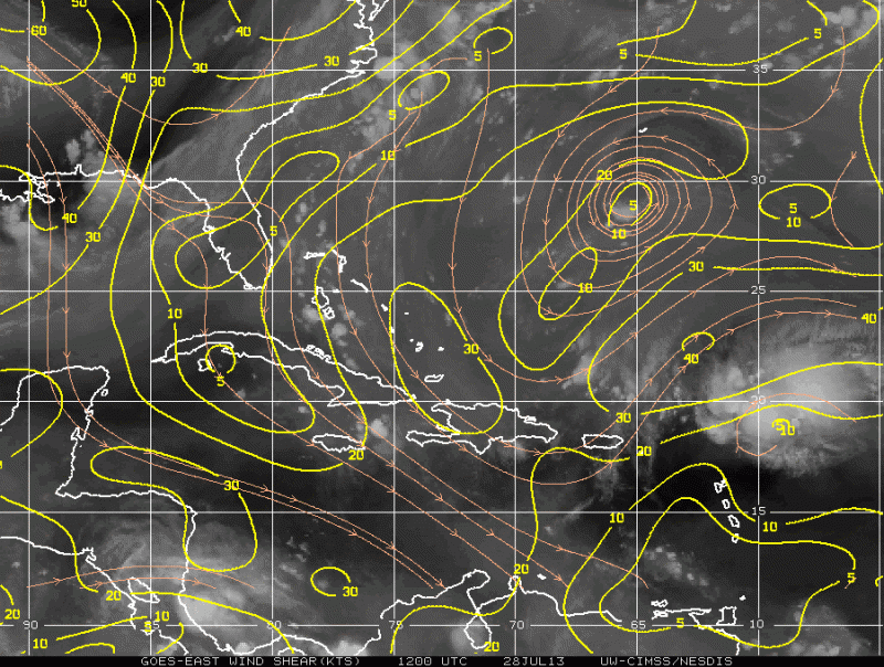
HURAKAN wrote:If you see the shear graphic above and watch a loop of the remnants of Dorian, you notice that it's about to enter an area of higher shear. I don't see any surface circulation, so those thunderstorms will likely die down as they did yesterday.
That is what I think will happen also.
But as I posted Friday afternoon, I was not going to completely take my eye of this until completely dissipated because you just never know with these systems.
I thought this thing might have been done yesterday.
Hopefully this convection does die by the end-of-day. Conditions could be favorable in the Bahamas for this system as SHIPS is showing.
0 likes
-
cycloneye
- Admin
- Posts: 149498
- Age: 69
- Joined: Thu Oct 10, 2002 10:54 am
- Location: San Juan, Puerto Rico
Re: ATL: DORIAN - Models
Here is the full text of 12z guidance for 91L. WOW!!
TROPICAL CYCLONE GUIDANCE MESSAGE
NWS NATIONAL HURRICANE CENTER MIAMI FL
1235 UTC SUN JUL 28 2013
DISCLAIMER...NUMERICAL MODELS ARE SUBJECT TO LARGE ERRORS.
PLEASE REFER TO NHC OFFICIAL FORECASTS FOR TROPICAL CYCLONE
AND SUBTROPICAL CYCLONE INFORMATION.
ATLANTIC OBJECTIVE AIDS FOR
DISTURBANCE INVEST (AL912013) 20130728 1200 UTC
...00 HRS... ...12 HRS... ...24 HRS... ...36 HRS...
130728 1200 130729 0000 130729 1200 130730 0000
LAT LON LAT LON LAT LON LAT LON
BAMS 19.3N 59.5W 20.2N 62.7W 20.8N 65.8W 21.7N 68.9W
BAMD 19.3N 59.5W 20.2N 61.9W 21.1N 64.2W 21.9N 66.4W
BAMM 19.3N 59.5W 19.9N 62.3W 20.5N 65.0W 21.1N 67.6W
LBAR 19.3N 59.5W 20.1N 62.5W 20.7N 65.4W 21.2N 68.1W
SHIP 30KTS 35KTS 41KTS 46KTS
DSHP 30KTS 35KTS 41KTS 46KTS
...48 HRS... ...72 HRS... ...96 HRS... ..120 HRS...
130730 1200 130731 1200 130801 1200 130802 1200
LAT LON LAT LON LAT LON LAT LON
BAMS 22.4N 71.9W 23.6N 77.4W 25.2N 81.0W 26.9N 81.9W
BAMD 22.5N 68.5W 23.4N 72.3W 24.6N 75.8W 26.8N 77.9W
BAMM 21.7N 70.2W 22.5N 74.6W 24.0N 78.3W 26.3N 80.0W
LBAR 21.4N 70.6W 21.7N 75.6W 23.5N 80.0W 28.0N 80.3W
SHIP 51KTS 59KTS 69KTS 78KTS
DSHP 51KTS 59KTS 69KTS 78KTS
...INITIAL CONDITIONS...
LATCUR = 19.3N LONCUR = 59.5W DIRCUR = 280DEG SPDCUR = 19KT
LATM12 = 18.6N LONM12 = 55.6W DIRM12 = 280DEG SPDM12 = 19KT
LATM24 = 18.4N LONM24 = 51.4W
WNDCUR = 30KT RMAXWD = 60NM WNDM12 = 30KT
CENPRS = 1012MB OUTPRS = 1016MB OUTRAD = 120NM SDEPTH = S
RD34NE = 0NM RD34SE = 0NM RD34SW = 0NM RD34NW = 0NM
0 likes
Visit the Caribbean-Central America Weather Thread where you can find at first post web cams,radars
and observations from Caribbean basin members Click Here
and observations from Caribbean basin members Click Here
-
HURAKAN

- Professional-Met

- Posts: 46084
- Age: 39
- Joined: Thu May 20, 2004 4:34 pm
- Location: Key West, FL
- Contact:
Re:
NDG wrote:Very light west winds started being reported at Burbuda. Prior to this it was very light northerly winds.
Antigua and Barbuda is reporting NE 3 mph.
http://weather.noaa.gov/weather/current/TAPA.html
0 likes


Who is online
Users browsing this forum: Google [Bot] and 45 guests