ATL: DORIAN - Post-Tropical - Discussion

Moderator: S2k Moderators

Message
Author
User avatar
wxman57
Moderator-Pro Met
Moderator-Pro Met
Posts: 22980
Age: 67
Joined: Sat Jun 21, 2003 8:06 pm
Location: Houston, TX (southwest)

Re: ATL: INVEST 91L - Dorian Remnants - Discussion

#2101 Postby wxman57 » Sun Jul 28, 2013 9:04 am

ronjon wrote:Is that a rotation off the PR RADAR I see to the NE - probably mid-level but interesting.


The center of Dorian's remnants is over 300 miles away from the radar. That puts the center of the beam at around 65,000 ft. and the bottom of the beam around 55,000 ft.
0 likes   

User avatar
gatorcane
S2K Supporter
S2K Supporter
Posts: 23691
Age: 47
Joined: Sun Mar 13, 2005 3:54 pm
Location: Boca Raton, FL

Re: ATL: INVEST 91L - Dorian Remnants - Discussion

#2102 Postby gatorcane » Sun Jul 28, 2013 9:09 am

wxman57 wrote:I'm not seeing any rotation at the surface. Plotted some ships around Dorian and noted that the pressure is quite high around Dorian - 1017 to 1018mb, and 1016mb in the eastern Caribbean. Much higher than normal. Redevelopment chances still look to be low.

I annoted the SSD vis floater with the red arrows to show where I see the rotation -- could just be a temporary mid-level rotation that dissipates in a few hours though. Convection should (hopefully) diminish alot by this afternoon (DMIN).

Here is the loop again:
http://www.ssd.noaa.gov/PS/TROP/floater ... -long.html

Image
Last edited by gatorcane on Sun Jul 28, 2013 9:16 am, edited 2 times in total.
0 likes   

User avatar
NDG
S2K Supporter
S2K Supporter
Posts: 15446
Joined: Sun Jul 09, 2006 10:14 pm
Location: Orlando, FL

#2103 Postby NDG » Sun Jul 28, 2013 9:13 am

Unlike yesterday about this time, convection keeps refiring near the suspected COC.
0 likes   

User avatar
ScottNAtlanta
Category 5
Category 5
Posts: 2367
Joined: Sat May 25, 2013 3:11 pm
Location: Atlanta, GA

Re: ATL: INVEST 91L - Dorian Remnants - Discussion

#2104 Postby ScottNAtlanta » Sun Jul 28, 2013 9:14 am

There is a very fine line between destructive shear and beneficial ventilation. I think we are seeing the later currently. There is good outflow developing in most every direction. Also, dont see much die off of the thunderstorms approaching the DMIN as has been the case in the past. Remember, the atmosphere is fluid. Shear in a specific location might not be there 12 hours from now
0 likes   
The posts in this forum are NOT official forecast and should not be used as such. They are just the opinion of the poster and may or may not be backed by sound meteorological data. They are NOT endorsed by any professional institution or storm2k.org. For official information, please refer to the NHC and NWS products.

User avatar
Blown Away
S2K Supporter
S2K Supporter
Posts: 10148
Joined: Wed May 26, 2004 6:17 am

Re: ATL: INVEST 91L - Models

#2105 Postby Blown Away » Sun Jul 28, 2013 9:15 am

06z GFS...Generally carries 91L as low to SFL...Past runs burried the low in Cuba...
http://www.tropicaltidbits.com/analysis ... opics.html
0 likes   
Hurricane Eye Experience: David 79, Irene 99, Frances 04, Jeanne 04, Wilma 05... EYE COMING MY WAY IN 2024…
Hurricane Brush Experience: Andrew 92, Erin 95, Floyd 99, Matthew 16, Irma 17, Ian 22, Nicole 22…

User avatar
Blown Away
S2K Supporter
S2K Supporter
Posts: 10148
Joined: Wed May 26, 2004 6:17 am

Re: ATL: INVEST 91L - Dorian Remnants - Discussion

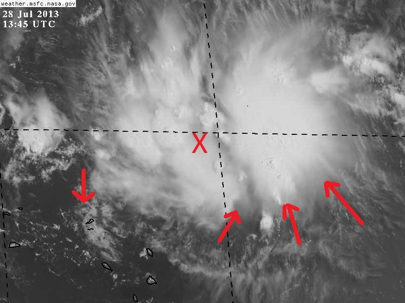
#2106 Postby Blown Away » Sun Jul 28, 2013 9:17 am

ScottNAtlanta wrote:There is a very fine line between destructive shear and beneficial ventilation. I think we are seeing the later currently. There is good outflow developing in most every direction. Also, dont see much die off of the thunderstorms approaching the DMIN as has been the case in the past. Remember, the atmosphere is fluid. Shear in a specific location might not be there 12 hours from now


ATLANTIC SHIPS INTENSITY FORECAST *
* GOES AVAILABLE, OHC AVAILABLE *
* INVEST AL912013 07/28/13 12 UTC *

TIME (HR) 0 6 12 18 24 36 48 60 72 84 96 108 120
SHEAR (KT) 12 10 11 14 13 9 14 9 16 6 14 7 11


If 12z is right, shear should not be the issue...
0 likes   
Hurricane Eye Experience: David 79, Irene 99, Frances 04, Jeanne 04, Wilma 05... EYE COMING MY WAY IN 2024…
Hurricane Brush Experience: Andrew 92, Erin 95, Floyd 99, Matthew 16, Irma 17, Ian 22, Nicole 22…

User avatar
cycloneye
Admin
Admin
Posts: 145469
Age: 68
Joined: Thu Oct 10, 2002 10:54 am
Location: San Juan, Puerto Rico

Re: ATL: INVEST 91L - Dorian Remnants - Discussion

#2107 Postby cycloneye » Sun Jul 28, 2013 9:20 am

This is why is good to upload images to save them. Here is how it looked on Saturday Morning at 3:15 AM UTC.

Image
0 likes   
Visit the Caribbean-Central America Weather Thread where you can find at first post web cams,radars
and observations from Caribbean basin members Click Here

User avatar
ScottNAtlanta
Category 5
Category 5
Posts: 2367
Joined: Sat May 25, 2013 3:11 pm
Location: Atlanta, GA

Re: ATL: INVEST 91L - Dorian Remnants - Discussion

#2108 Postby ScottNAtlanta » Sun Jul 28, 2013 9:22 am

This looks like its worthy of some attention (note intensity)

Image
0 likes   
The posts in this forum are NOT official forecast and should not be used as such. They are just the opinion of the poster and may or may not be backed by sound meteorological data. They are NOT endorsed by any professional institution or storm2k.org. For official information, please refer to the NHC and NWS products.

User avatar
Evil Jeremy
S2K Supporter
S2K Supporter
Posts: 5463
Age: 32
Joined: Mon Apr 10, 2006 2:10 pm
Location: Los Angeles, CA

Re: ATL: INVEST 91L - Dorian Remnants - Discussion

#2109 Postby Evil Jeremy » Sun Jul 28, 2013 9:22 am

I honestly don't see much rotation. The inflow that developed this morning seems to be tapering off, and I don't expect recon to find anything today.
0 likes   
Frances 04 / Jeanne 04 / Katrina 05 / Wilma 05 / Fay 08 / Debby 12 / Andrea 13 / Colin 16 / Hermine 16 / Matthew 16 / Irma 17

User avatar
ROCK
Category 5
Category 5
Posts: 9484
Age: 54
Joined: Tue Aug 17, 2004 7:30 am
Location: Kemah, Texas

Re: ATL: INVEST 91L - Dorian Remnants - Discussion

#2110 Postby ROCK » Sun Jul 28, 2013 9:23 am

Wait ...I thought this guy was dead...Bomes and all!! :lol:

If the NAM pulls this out of its butt I will never again make fun of it...
0 likes   

User avatar
NDG
S2K Supporter
S2K Supporter
Posts: 15446
Joined: Sun Jul 09, 2006 10:14 pm
Location: Orlando, FL

Re: ATL: INVEST 91L - Dorian Remnants - Discussion

#2111 Postby NDG » Sun Jul 28, 2013 9:24 am

Evil Jeremy wrote:I honestly don't see much rotation. The inflow that developed this morning seems to be tapering off, and I don't expect recon to find anything today.


I still see a nice inflow on HR sat loop, even more than earlier this morning.

http://weather.msfc.nasa.gov/cgi-bin/post-goes
0 likes   

User avatar
AtlanticWind
S2K Supporter
S2K Supporter
Posts: 1890
Age: 66
Joined: Sun Aug 08, 2004 9:57 pm
Location: Plantation,Fla

#2112 Postby AtlanticWind » Sun Jul 28, 2013 9:25 am

If there is a closed circulation under that convection I do not see any reason this can not intensify to a strong tropical storm in the Bahamas .
0 likes   

User avatar
SFLcane
S2K Supporter
S2K Supporter
Posts: 10163
Age: 47
Joined: Sat Jun 05, 2010 1:44 pm
Location: Lake Worth Florida

Re: ATL: INVEST 91L - Dorian Remnants - Discussion

#2113 Postby SFLcane » Sun Jul 28, 2013 9:26 am

Can use PR ssd images until they put floater up.

http://www.ssd.noaa.gov/goes/east/pr.html

Image
0 likes   

wxsouth
Professional-Met
Professional-Met
Posts: 69
Joined: Sat Jul 09, 2005 6:57 am

#2114 Postby wxsouth » Sun Jul 28, 2013 9:26 am

Not positive that there is a closed circulation, but it's not out of the question. What I do see is a very sharp trough axis extending down to at least Guadaloupe. On satellite, you can see that the low clouds around Guadaloupe are nearly stationary. The winds at Barbuda are interesting as well, although these could be due to local affects.

None of this may matter however, if the strong southerly upper winds just ahead of the system don't diminish (and quickly).
0 likes   

User avatar
NDG
S2K Supporter
S2K Supporter
Posts: 15446
Joined: Sun Jul 09, 2006 10:14 pm
Location: Orlando, FL

#2115 Postby NDG » Sun Jul 28, 2013 9:27 am

This station in Barbuda has now reported a westerly wind component for nearly 30 minutes now, off and on over an hour.

07 28 10:54 am WSW 6.0 8.0 - - - - 30.01 - 79.9 - - - - -
07 28 10:48 am WSW 6.0 8.9 - - - - 30.01 - 79.5 - - - - -
07 28 10:42 am SW 8.0 8.9 - - - - 30.02 - 78.3 - - - - -
07 28 10:36 am WSW 7.0 9.9 - - - - 30.02 - 78.6 - - - - -
07 28 10:30 am SSW 11.1 12.0 - - - - 30.02 - 78.3 - - - - -
07 28 10:24 am SSW 11.1 15.9 - - - - 30.02 - 78.6

http://www.ndbc.noaa.gov/station_page.php?station=bara9
0 likes   

User avatar
funster
Category 3
Category 3
Posts: 817
Joined: Sat Dec 29, 2007 4:27 pm
Location: North Dallas

#2116 Postby funster » Sun Jul 28, 2013 9:28 am

There is floater available, under 91L: http://www.ssd.noaa.gov/PS/TROP/floater ... oater.html
0 likes   

User avatar
Blown Away
S2K Supporter
S2K Supporter
Posts: 10148
Joined: Wed May 26, 2004 6:17 am

Re: ATL: INVEST 91L - Models

#2117 Postby Blown Away » Sun Jul 28, 2013 9:29 am

Image
Image
0 likes   
Hurricane Eye Experience: David 79, Irene 99, Frances 04, Jeanne 04, Wilma 05... EYE COMING MY WAY IN 2024…
Hurricane Brush Experience: Andrew 92, Erin 95, Floyd 99, Matthew 16, Irma 17, Ian 22, Nicole 22…

User avatar
cycloneye
Admin
Admin
Posts: 145469
Age: 68
Joined: Thu Oct 10, 2002 10:54 am
Location: San Juan, Puerto Rico

Re: ATL: INVEST 91L - Dorian Remnants - Discussion

#2118 Postby cycloneye » Sun Jul 28, 2013 9:31 am

0 likes   
Visit the Caribbean-Central America Weather Thread where you can find at first post web cams,radars
and observations from Caribbean basin members Click Here

User avatar
NDG
S2K Supporter
S2K Supporter
Posts: 15446
Joined: Sun Jul 09, 2006 10:14 pm
Location: Orlando, FL

#2119 Postby NDG » Sun Jul 28, 2013 9:36 am

I place the X where I suspect an LLC is developing, I can clearly see the inflow at the low levels on the hr satellite loop.

Image
0 likes   

User avatar
ScottNAtlanta
Category 5
Category 5
Posts: 2367
Joined: Sat May 25, 2013 3:11 pm
Location: Atlanta, GA

Re: ATL: INVEST 91L - Dorian Remnants - Discussion

#2120 Postby ScottNAtlanta » Sun Jul 28, 2013 9:37 am

This is not implying anything...but saw this elsewhere and found it interesting looking at the comparison of conditions (not same time of year either)

Image

Image
0 likes   
The posts in this forum are NOT official forecast and should not be used as such. They are just the opinion of the poster and may or may not be backed by sound meteorological data. They are NOT endorsed by any professional institution or storm2k.org. For official information, please refer to the NHC and NWS products.


Return to “2013”

Who is online

Users browsing this forum: No registered users and 5 guests