ATL: DORIAN - Post-Tropical - Discussion
Moderator: S2k Moderators

Re: ATL: INVEST 91L - Dorian Remnants - Discussion
Dry air is typical of July. So is the higher surface pressures in the tropics, also typical in July. If the surface pressures were lower, than rising moist air would perhaps also help be a better catalyst in overall convection. But if I had to list the most inhibiting factor, i'd say the dry air has been the primary culprit.
0 likes
Andy D
(For official information, please refer to the NHC and NWS products.)
(For official information, please refer to the NHC and NWS products.)
-
TropicalAnalystwx13

- Category 5

- Posts: 2109
- Age: 28
- Joined: Tue Jul 19, 2011 8:20 pm
- Location: Wilmington, NC
- Contact:
Re: ATL: INVEST 91L - Dorian Remnants - Discussion
chaser1 wrote:Dry air is typical of July. So is the higher surface pressures in the tropics, also typical in July. If the surface pressures were lower, than rising moist air would perhaps also help be a better catalyst in overall convection. But if I had to list the most inhibiting factor, i'd say the dry air has been the primary culprit.
Per the 0z SHIPS file, 91L is moving at 280°/16kt (north of west at 18 mph).
Last edited by TropicalAnalystwx13 on Sun Jul 28, 2013 7:31 pm, edited 1 time in total.
0 likes
-
jlauderdal
- S2K Supporter

- Posts: 7240
- Joined: Wed May 19, 2004 5:46 am
- Location: NE Fort Lauderdale
- Contact:
Re: ATL: INVEST 91L - Dorian Remnants - Discussion
Blown Away wrote:bahamaswx wrote:TheStormExpert wrote:What about shear? Isn't shear still going to be an issue starting tonight or tomorrow?
Shear has supposed to have been an issue all day, and the pocket of high shear is immediately to his west, but is pretty much moving west in tandem with ex-Dorian.
ATLANTIC SHIPS INTENSITY FORECAST *
* GOES AVAILABLE, OHC AVAILABLE *
* DORIAN AL912013 07/28/13 18 UTC *
TIME (HR) 0 6 12 18 24 36 48 60 72 84 96 108 120
SHEAR (KT) 14 16 19 16 14 14 9 15 9 8 9 7 9
VERY LOW COMPARED TO PREDICTIONS OVER PAST FEW DAYS...
What image does wxman57 have in the event of regeneration
Sent Using Tapatalk2
0 likes


-
cycloneye

- Admin

- Posts: 149480
- Age: 69
- Joined: Thu Oct 10, 2002 10:54 am
- Location: San Juan, Puerto Rico
Re:
TropicalAnalystwx13 wrote:AL, 91, 2013072900, , BEST, 0, 204N, 620W, 35, 1011, WV, 34, NEQ, 60, 0, 0, 40, 1015, 100, 60, 0, 0, L, 0, , 0, 0, DORIAN, M,
That position is a little bit closer to the convection.
0 likes
Visit the Caribbean-Central America Weather Thread where you can find at first post web cams,radars
and observations from Caribbean basin members Click Here
and observations from Caribbean basin members Click Here
-
Blown Away

- S2K Supporter
- Posts: 10253
- Joined: Wed May 26, 2004 6:17 am
Re:
TropicalAnalystwx13 wrote:AL, 91, 2013072900, , BEST, 0, 204N, 620W, 35, 1011, WV, 34, NEQ, 60, 0, 0, 40, 1015, 100, 60, 0, 0, L, 0, , 0, 0, DORIAN, M,

0 likes
Hurricane Eye Experience: David 79, Irene 99, Frances 04, Jeanne 04, Wilma 05… Hurricane Brush Experience: Andrew 92, Erin 95, Floyd 99, Matthew 16, Irma 17, Ian 22, Nicole 22…

Re: ATL: INVEST 91L - Dorian Remnants - Discussion
ATLANTIC SHIPS INTENSITY FORECAST *
* GOES AVAILABLE, OHC AVAILABLE *
* DORIAN AL912013 07/28/13 18 UTC *
TIME (HR) 0 6 12 18 24 36 48 60 72 84 96 108 120
SHEAR (KT) 14 16 19 16 14 14 9 15 9 8 9 7 9
VERY LOW COMPARED TO PREDICTIONS OVER PAST FEW DAYS..
If it's really gotten its act together, than by about 48 hours the shear really drops off. That coupled with warmer gulfstream waters could make things a little dicey.
0 likes
Andy D
(For official information, please refer to the NHC and NWS products.)
(For official information, please refer to the NHC and NWS products.)
-
MGC

- S2K Supporter
- Posts: 5940
- Joined: Sun Mar 23, 2003 9:05 pm
- Location: Pass Christian MS, or what is left.
Re: ATL: INVEST 91L - Dorian Remnants - Discussion
Dorian: Rumors of my demise have been greatly exaggerated!
Nice convective blowup....lets see if it persists.....MGC
Nice convective blowup....lets see if it persists.....MGC
0 likes
-
Blown Away
- S2K Supporter
- Posts: 10253
- Joined: Wed May 26, 2004 6:17 am
Re: ATL: INVEST 91L - Dorian Remnants - Discussion
What image does wxman57 have in the event of regeneration
Yes, we need to find a funny/creative image for this situation....
0 likes
Hurricane Eye Experience: David 79, Irene 99, Frances 04, Jeanne 04, Wilma 05… Hurricane Brush Experience: Andrew 92, Erin 95, Floyd 99, Matthew 16, Irma 17, Ian 22, Nicole 22…
-
cycloneye
- Admin
- Posts: 149480
- Age: 69
- Joined: Thu Oct 10, 2002 10:54 am
- Location: San Juan, Puerto Rico
Re: ATL: INVEST 91L - Models
00z guidance.
WHXX01 KWBC 290022
CHGHUR
TROPICAL CYCLONE GUIDANCE MESSAGE
NWS NATIONAL HURRICANE CENTER MIAMI FL
0022 UTC MON JUL 29 2013
DISCLAIMER...NUMERICAL MODELS ARE SUBJECT TO LARGE ERRORS.
PLEASE REFER TO NHC OFFICIAL FORECASTS FOR TROPICAL CYCLONE
AND SUBTROPICAL CYCLONE INFORMATION.
ATLANTIC OBJECTIVE AIDS FOR
DISTURBANCE DORIAN (AL912013) 20130729 0000 UTC
...00 HRS... ...12 HRS... ...24 HRS. .. ...36 HRS...
130729 0000 130729 1200 130730 0000 130730 1200
LAT LON LAT LON LAT LON LAT LON
BAMS 20.4N 62.0W 21.2N 65.0W 22.0N 68.0W 22.7N 70.9W
BAMD 20.4N 62.0W 21.4N 64.3W 22.3N 66.4W 22.9N 68.4W
BAMM 20.4N 62.0W 21.0N 64.7W 21.6N 67.2W 22.1N 69.7W
LBAR 20.4N 62.0W 21.2N 64.8W 21.7N 67.3W 22.1N 69.7W
SHIP 35KTS 37KTS 40KTS 43KTS
DSHP 35KTS 37KTS 40KTS 43KTS
...48 HRS... ...72 HRS... ...96 HRS. .. ..120 HRS...
130731 0000 130801 0000 130802 0000 130803 0000
LAT LON LAT LON LAT LON LAT LON
BAMS 23.3N 73.7W 24.4N 78.5W 25.7N 81.3W 26.7N 82.6W
BAMD 23.4N 70.2W 24.1N 73.8W 25.5N 77.1W 27.0N 78.9W
BAMM 22.4N 71.9W 22.9N 76.1W 24.2N 79.2W 25.8N 80.9W
LBAR 22.4N 72.0W 22.9N 76.6W 24.2N 80.2W 26.3N 81.8W
SHIP 47KTS 55KTS 65KTS 71KTS
DSHP 47KTS 55KTS 65KTS 52KTS
...INITIAL CONDITIONS...
LATCUR = 20.4N LONCUR = 62.0W DIRCUR = 280DEG SPDCUR = 16KT
LATM12 = 19.7N LONM12 = 58.6W DIRM12 = 282DEG SPDM12 = 17KT
LATM24 = 19.0N LONM24 = 54.8W
WNDCUR = 35KT RMAXWD = 60NM WNDM12 = 35KT
CENPRS = 1011MB OUTPRS = 1015MB OUTRAD = 100NM SDEPTH = M
RD34NE = 60NM RD34SE = 0NM RD34SW = 0NM RD34NW = 40NM
0 likes
Visit the Caribbean-Central America Weather Thread where you can find at first post web cams,radars
and observations from Caribbean basin members Click Here
and observations from Caribbean basin members Click Here
Re: ATL: INVEST 91L - Dorian Remnants - Discussion
Dorian coming into the 1KM NASA Interactive Satellite site - http://weather.msfc.nasa.gov/cgi-bin/post-goes
0 likes
Andy D
(For official information, please refer to the NHC and NWS products.)
(For official information, please refer to the NHC and NWS products.)


Re: ATL: INVEST 91L - Dorian Remnants - Discussion
MGC wrote:Dorian: Rumors of my demise have been greatly exaggerated!
Nice convective blowup....lets see if it persists.....MGC
Did Dorian call or send you a text.
0 likes
-
Blown Away
- S2K Supporter
- Posts: 10253
- Joined: Wed May 26, 2004 6:17 am
Re: ATL: INVEST 91L - Models
0 likes
Hurricane Eye Experience: David 79, Irene 99, Frances 04, Jeanne 04, Wilma 05… Hurricane Brush Experience: Andrew 92, Erin 95, Floyd 99, Matthew 16, Irma 17, Ian 22, Nicole 22…
-
ozonepete
- Professional-Met

- Posts: 4743
- Joined: Mon Sep 07, 2009 3:23 pm
- Location: From Ozone Park, NYC / Now in Brooklyn, NY
Re: ATL: INVEST 91L - Dorian Remnants - Discussion
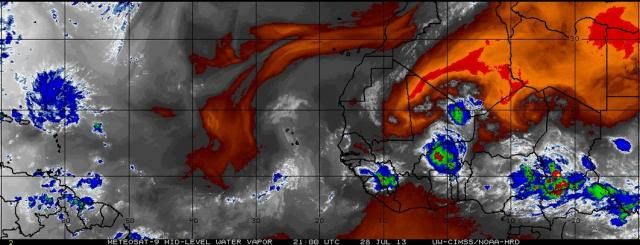
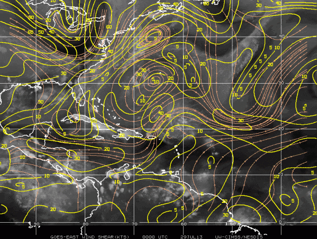
DMIN is over. Heading for DMAX now. Dry air about to become a non-issue. Look at the mid-level water vapor. It's heading into a very deep moist environment now. Shear will be the problem for the next 1-2 days since it has slowed down. However that area of shear to the west and northwest has really shrunk in coverage and, as we've been saying, is retrograding and lessening each day. I would agree with Stacy that should it survive that shear it could be a real problem for the western Bahamas and Florida.


Water Vapor at mid-levels:
Shear:


Water Vapor at mid-levels:

Shear:

0 likes

-
cycloneye
- Admin
- Posts: 149480
- Age: 69
- Joined: Thu Oct 10, 2002 10:54 am
- Location: San Juan, Puerto Rico
Re: ATL: INVEST 91L - Dorian Remnants - Discussion
Anticyclone looking good.

0 likes
Visit the Caribbean-Central America Weather Thread where you can find at first post web cams,radars
and observations from Caribbean basin members Click Here
and observations from Caribbean basin members Click Here
-
weatherwindow

- Category 4

- Posts: 904
- Joined: Mon Sep 20, 2004 9:48 am
- Location: key west/ft lauderdale
Re:
gatorcane wrote:Well DMAX is coming up tonight, and there is some popping convection near the MLC already. If we see convection increase around there tonight, that would indicate an LLC is forming there and this certainly can become a Tropical Storm again quite quickly.
Good evening, Chris...Certainly agree with above...Obviously, several factors are going to have to come together for that to happen. As you noted, this Dmax is going to be critical in order to initiate the preliminary pressure falls and initate the first stage of LLC consolidation. In addition, it should further warm the air column and reinforce the critical anticyclone. One of the primary reasons that I have some degree of confidence in the ultimate regeneration is the very favourable outflow in place over the trof. As 91L has slowed to a speed more in line with the ambient flow, the threat of shear has lessoned as the TUTT now appears to be moving in tandem with 91L. As noted elsewhere, SSTs are continuing to increase thruout the projected track. IMO, the only bugaboo 91L is facing in the near term is the ongoing problem of dry air. With that single exception, I believe all the pieces appear to be in place for regeneration...save the assent of the weather gods
This should not be construed as a forecast. It is simply the opinion and reasoning of an informed amateur. These conclusions are not supported by storm2k, the NWS, or the NHC. The NWS or the NHC should be consulted for official forecasts and overall storm information
0 likes

-
Blown Away
- S2K Supporter
- Posts: 10253
- Joined: Wed May 26, 2004 6:17 am
Re: ATL: INVEST 91L - Dorian Remnants - Discussion
ozonepete wrote:DMIN is over. Heading for DMAX now. Dry air about to become a non-issue. Look at the mid-level water vapor. It's heading into a very deep moist environment now. Shear will be the problem for the next 1-2 days since it has slowed down. However that area of shear to the west and northwest has really shrunk in coverage and, as we've been saying, is retrograding and lessening each day. I would agree with Stacy that should it survive that shear it could be a real problem for the western Bahamas and Florida.
SST, shear, and dry air appear to be non issue in 24+hrs, why are the global models showing nothing?? None of the models show anything but a wave?? Will that change if Dorian makes a comeback tonight?
0 likes
Hurricane Eye Experience: David 79, Irene 99, Frances 04, Jeanne 04, Wilma 05… Hurricane Brush Experience: Andrew 92, Erin 95, Floyd 99, Matthew 16, Irma 17, Ian 22, Nicole 22…
Who is online
Users browsing this forum: No registered users and 43 guests