ATL: ANDREA - Post-Tropical

Moderator: S2k Moderators

Message
Author
User avatar
NDG
S2K Supporter
S2K Supporter
Posts: 15446
Joined: Sun Jul 09, 2006 10:14 pm
Location: Orlando, FL

#261 Postby NDG » Tue Jun 04, 2013 8:53 am

X is the naked low level circulation that is evident on satellite and that the NHC placed as the best track position, it is moving westward.
The circled area is where we may see a new LLC form closer to the convection, IMO.

Image
0 likes   

User avatar
GCANE
S2K Supporter
S2K Supporter
Posts: 11496
Joined: Mon Oct 22, 2007 8:03 am

Re: ATL: INVEST 91L

#262 Postby GCANE » Tue Jun 04, 2013 9:10 am

IMHO, it looks like the swirl is moving to the west.

The more west it moves, the more it gets away from the 200mb PV anomaly over it.

http://tropic.ssec.wisc.edu/real-time/a ... g8vor1.GIF

Basically, that is what is putting a lid on convection since it is pushing down on parcel ascent.

Maybe then, LL convergence can kick in and fire off convection.

Need to wait and see.
0 likes   

jlauderdal
S2K Supporter
S2K Supporter
Posts: 7182
Joined: Wed May 19, 2004 5:46 am
Location: NE Fort Lauderdale
Contact:

Re: ATL: INVEST 91L

#263 Postby jlauderdal » Tue Jun 04, 2013 9:12 am

wzrgirl1 wrote:Why Jlauderdale? Because of dry air? Confused..... :eek:


plenty of moisture to work with just not much lift to make it an efficient rain producer, lets see what happens later today and tomorrow, looks better each day as the low finally pulls out and the front gets closer...not much was supposed to happen until weds anyway so we are right ons chedule
0 likes   

adam0983

Re: ATL: INVEST 91L

#264 Postby adam0983 » Tue Jun 04, 2013 9:14 am

This invest 91L is very impressive for an Invest because of how far the Rainfield extends with this Invest. It extends from Cozumel all the way to Port Saint Lucie Florida. That's Impressive.
0 likes   

User avatar
wxman57
Moderator-Pro Met
Moderator-Pro Met
Posts: 22978
Age: 67
Joined: Sat Jun 21, 2003 8:06 pm
Location: Houston, TX (southwest)

Re: ATL: INVEST 91L

#265 Postby wxman57 » Tue Jun 04, 2013 9:18 am

GCANE wrote:IMHO, it looks like the swirl is moving to the west.

The more west it moves, the more it gets away from the 200mb PV anomaly over it.

http://tropic.ssec.wisc.edu/real-time/a ... g8vor1.GIF

Basically, that is what is putting a lid on convection since it is pushing down on parcel ascent.

Maybe then, LL convergence can kick in and fire off convection.

Need to wait and see.


We can ignore that swirl. It IS heading off to the west away from all low-level convergence. Will probably start rotating SW soon and/or die out. Look just north of the Yucatan where low-level convergence has been increasing.
0 likes   

jlauderdal
S2K Supporter
S2K Supporter
Posts: 7182
Joined: Wed May 19, 2004 5:46 am
Location: NE Fort Lauderdale
Contact:

Re: ATL: INVEST 91L

#266 Postby jlauderdal » Tue Jun 04, 2013 9:19 am

adam0983 wrote:This invest 91L is very impressive for an Invest because of how far the Rainfield extends with this Invest. It extends from Cozumel all the way to Port Saint Lucie Florida. That's Impressive.


weak systems can be very large in size and rain for days, think of noname system back in 2002 or so in sofla, huge rain producer
0 likes   

User avatar
MGC
S2K Supporter
S2K Supporter
Posts: 5899
Joined: Sun Mar 23, 2003 9:05 pm
Location: Pass Christian MS, or what is left.

Re: ATL: INVEST 91L

#267 Postby MGC » Tue Jun 04, 2013 9:37 am

Naked circulation has little chance....low would have to reform near convection for anything to get going. Lots of dry air and shear still....MGC
0 likes   

User avatar
Miami Storm Tracker
Category 4
Category 4
Posts: 910
Age: 67
Joined: Sun Jun 13, 2010 10:12 pm
Location: Key Largo, Fla.
Contact:

Re:

#268 Postby Miami Storm Tracker » Tue Jun 04, 2013 9:38 am

[quote="NDG"]X is the naked low level circulation that is evident on satellite and that the NHC placed as the best track position, it is moving westward.
The circled area is where we may see a new LLC form closer to the convection, IMO.

NDG,

Any chance a new circulation could form further south east under that big ball of storms blowing up.


Image[/quot
0 likes   

tolakram
Admin
Admin
Posts: 20009
Age: 62
Joined: Sun Aug 27, 2006 8:23 pm
Location: Florence, KY (name is Mark)

Re: ATL: INVEST 91L

#269 Postby tolakram » Tue Jun 04, 2013 9:41 am

I don't think that swirl was identified as the center, I think it was the area south of it that the swirl is rotating around.

10 frame loop. Speed it up, but it won't really help. :) http://wwwghcc.msfc.nasa.gov/cgi-bin/ge ... mframes=10
0 likes   
M a r k
- - - - -
Join us in chat: Storm2K Chatroom Invite. Android and IOS apps also available.

The posts in this forum are NOT official forecasts and should not be used as such. Posts are NOT endorsed by any professional institution or STORM2K.org. For official information and forecasts, please refer to NHC and NWS products.

User avatar
NDG
S2K Supporter
S2K Supporter
Posts: 15446
Joined: Sun Jul 09, 2006 10:14 pm
Location: Orlando, FL

#270 Postby NDG » Tue Jun 04, 2013 9:43 am

Tampa area NWS office is right about talking about the possibility of severe weather for tomorrow and especially on Thursday, IMO.
GFS continues to show a strong low level jet developing.

AREA FORECAST DISCUSSION
NATIONAL WEATHER SERVICE TAMPA BAY RUSKIN FL
510 AM EDT TUE JUN 4 2013
MAY NEED A FLOOD WATCH FOR THIS TIME
PERIOD...BUT STILL A LITTLE EARLY TO ISSUE AS THE SYSTEM HAS GOT A
LONG WAY TO GO. FOR NOW HAVE ADDED MENTION OF HEAVY RAINFALL TO
THE FORECAST FOR THURSDAY AND WILL LET LATER SHIFTS EVALUATE THE
SITUATION TO SEE IF A FLOOD WATCH NEEDS TO BE ISSUED. ANOTHER
PARAMETER THAT WILL NEED TO BE WATCHED IS THE POTENTIAL FOR
WATERSPOUTS/WEAK TORNADOES LATE WEDNESDAY NIGHT THROUGH THURSDAY.
THE OVERALL INSTABILITY MAY BE LIMITED THANKS TO THE CLOUDS AND
RAINFALL...BUT THE LOW LEVEL SHEAR IS FORECAST TO INCREASE
SUBSTANTIALLY AND SOME OF THE STRONGER STORMS COULD PRODUCE
WATERSPOUTS/WEAK TORNADOES.
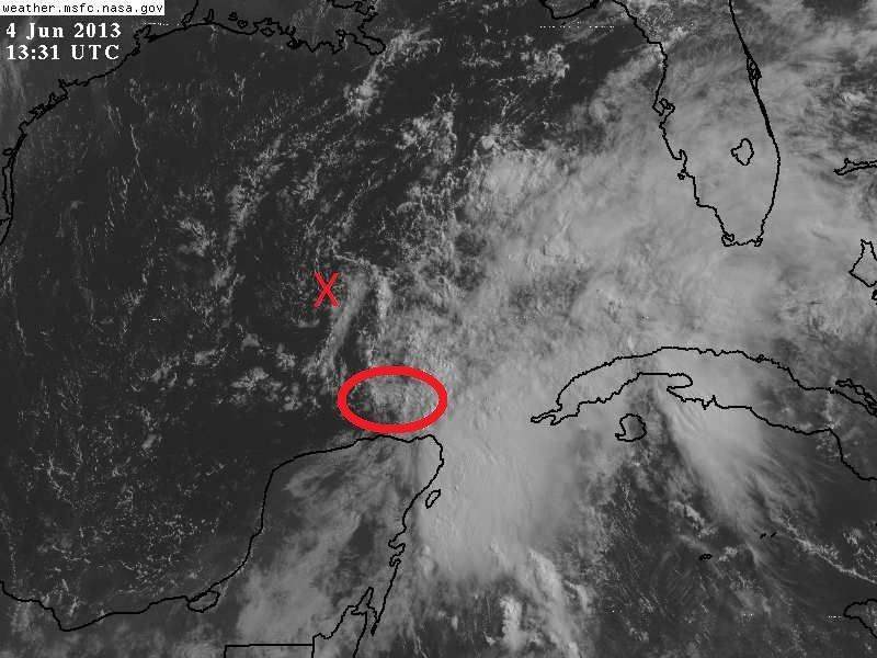

http://forecast.weather.gov/product.php ... glossary=1
0 likes   

User avatar
Evil Jeremy
S2K Supporter
S2K Supporter
Posts: 5463
Age: 32
Joined: Mon Apr 10, 2006 2:10 pm
Location: Los Angeles, CA

#271 Postby Evil Jeremy » Tue Jun 04, 2013 9:44 am

That LLC is far seperated from the rest of 91L. Looks like the invest spit it out. I wouldn't be surprised to see a new LLC form today in the convection ball west of Cozumel.
0 likes   
Frances 04 / Jeanne 04 / Katrina 05 / Wilma 05 / Fay 08 / Debby 12 / Andrea 13 / Colin 16 / Hermine 16 / Matthew 16 / Irma 17

User avatar
NDG
S2K Supporter
S2K Supporter
Posts: 15446
Joined: Sun Jul 09, 2006 10:14 pm
Location: Orlando, FL

Re: Re:

#272 Postby NDG » Tue Jun 04, 2013 9:46 am

Miami Storm Tracker wrote:
NDG wrote:X is the naked low level circulation that is evident on satellite and that the NHC placed as the best track position, it is moving westward.
The circled area is where we may see a new LLC form closer to the convection, IMO.

NDG,

Any chance a new circulation could form further south east under that big ball of storms blowing up.


http://i20.photobucket.com/albums/b245/ ... 7e9d6d.jpg[/quot


I don't see that, if anything the convection is moving closer to the circled area.
0 likes   

User avatar
GCANE
S2K Supporter
S2K Supporter
Posts: 11496
Joined: Mon Oct 22, 2007 8:03 am

Re: ATL: INVEST 91L

#273 Postby GCANE » Tue Jun 04, 2013 9:54 am

wxman57 wrote:
GCANE wrote:IMHO, it looks like the swirl is moving to the west.

The more west it moves, the more it gets away from the 200mb PV anomaly over it.

http://tropic.ssec.wisc.edu/real-time/a ... g8vor1.GIF

Basically, that is what is putting a lid on convection since it is pushing down on parcel ascent.

Maybe then, LL convergence can kick in and fire off convection.

Need to wait and see.


We can ignore that swirl. It IS heading off to the west away from all low-level convergence. Will probably start rotating SW soon and/or die out. Look just north of the Yucatan where low-level convergence has been increasing.


That swirl has been there for a good 24 hours.

If RAP is right, which is showing strong 500mb theta-e convergence this afternoon maybe from that convective debris, WV Sat presentation should get moist looking quickly.

http://www.twisterdata.com/data/models/ ... 500_MB.png

I am rootin for the swirl - Go Swirl!
0 likes   

jlauderdal
S2K Supporter
S2K Supporter
Posts: 7182
Joined: Wed May 19, 2004 5:46 am
Location: NE Fort Lauderdale
Contact:

Re: ATL: INVEST 91L

#274 Postby jlauderdal » Tue Jun 04, 2013 10:00 am

wzrgirl1 wrote:Why Jlauderdale? Because of dry air? Confused..... :eek:


here you go, if we could get any kind of heating today then maybe something can get established but right now it looks like a damp cloudy day in sofla and not much more then light to moderate rain...weds, thurs, fri should be more active


AREA FORECAST DISCUSSION
NATIONAL WEATHER SERVICE MIAMI FL
1050 AM EDT TUE JUN 4 2013

UPDATE

RECENT SATELLITE IMAGERY INDICATES EXTENSIVE CLOUD COVER ACROSS
SOUTH FLORIDA AND ADJACENT WATERS WITH RECENT RADAR RETURNS
INDICATING LIGHT SHOWERS ACROSS MOST OF THE REGION. AS INDICATED
BY THE RECENT MESO-SCALE MODEL GUIDANCE...THESE CONDITIONS WILL
LIKELY HAMPER DEVELOPMENT OF THUNDERSTORMS ACROSS THE PENINSULA
TODAY. GIVEN THESE FACTORS...ONCE AGAIN CONSIDERED DROPPING THE
SHORT TERM POP'S AND REMOVING LOCALLY HEAVY RAINFALL WORDING.
HOWEVER...WITH PRE-EXISTING BOUNDARIES AND OTHER FACTORS THERE
STILL IS THE POTENTIAL FOR LOCALLY HEAVY RAINFALL IN ISOLATED
LOCATIONS.
0 likes   

Aric Dunn
Category 5
Category 5
Posts: 21238
Age: 42
Joined: Sun Sep 19, 2004 9:58 pm
Location: Ready for the Chase.
Contact:

Re: ATL: INVEST 91L

#275 Postby Aric Dunn » Tue Jun 04, 2013 10:13 am

wxman57 wrote:
GCANE wrote:IMHO, it looks like the swirl is moving to the west.

The more west it moves, the more it gets away from the 200mb PV anomaly over it.

http://tropic.ssec.wisc.edu/real-time/a ... g8vor1.GIF

Basically, that is what is putting a lid on convection since it is pushing down on parcel ascent.

Maybe then, LL convergence can kick in and fire off convection.

Need to wait and see.


We can ignore that swirl. It IS heading off to the west away from all low-level convergence. Will probably start rotating SW soon and/or die out. Look just north of the Yucatan where low-level convergence has been increasing.


yeah that area just off the Yucatan appears to have quite a bit more rotational energy associated with it. once it a solid llc can develop it will likely organize quite rapidly then just maintain TD or weak Ts for the remainder of its life.
0 likes   
Note: If I make a post that is brief. Please refer back to previous posts for the analysis or reasoning. I do not re-write/qoute what my initial post said each time.
If there is nothing before... then just ask :)

Space & Atmospheric Physicist, Embry-Riddle Aeronautical University,
I believe the sky is falling...

Dean4Storms
S2K Supporter
S2K Supporter
Posts: 6358
Age: 62
Joined: Sun Aug 31, 2003 1:01 pm
Location: Miramar Bch. FL

#276 Postby Dean4Storms » Tue Jun 04, 2013 10:14 am

We're dry over here as well. We need the rain!
0 likes   

User avatar
Dave
Retired Staff
Retired Staff
Posts: 13442
Age: 74
Joined: Tue Aug 01, 2006 3:57 pm
Location: Milan Indiana
Contact:

#277 Postby Dave » Tue Jun 04, 2013 10:39 am

WEDNESDAY JUNE 5 & THURSDAY JUNE 6

000
NOUS42 KNHC 041516
REPRPD
WEATHER RECONNAISSANCE FLIGHTS
CARCAH, NATIONAL HURRICANE CENTER, MIAMI, FL.
1115 AM EDT TUE 04 JUNE 2013
SUBJECT: TROPICAL CYCLONE PLAN OF THE DAY (TCPOD)
VALID 05/1100Z TO 06/1100Z JUNE 2013
TCPOD NUMBER.....13-004

I. ATLANTIC REQUIREMENTS
1. SUSPECT AREA -- GULF OG MEXICO
FLIGHT ONE -- TEAL 70
A. 05/1900Z
B. AFXXX 01AAA INVEST
C. 05/1730Z
D. 24.0N 89.0W
E. 05/1830Z TO 05/2300Z
F. SFC TO 10,000 FT

FLIGHT TWO -- TEAL 71
A. 06/0600Z
B. AFXXX 0201A CYCLONE
C. 06/0415Z
D. 25.5N 88.0W
E. 06/0530 TO 06/1000Z
F. SFC TO 10,000 FT

2. OUTLOOK FOR SUCCEEDING DAY: PSBL FIX MISSION
NEAR 27.0N AND 86.0W AT 06/1800Z

3. REMARKS: THE IVEST SCHEDULED FOR 04/1900Z WAS CANX
BY NHC AT 04/1300Z.
0 likes   

User avatar
Dave
Retired Staff
Retired Staff
Posts: 13442
Age: 74
Joined: Tue Aug 01, 2006 3:57 pm
Location: Milan Indiana
Contact:

#278 Postby Dave » Tue Jun 04, 2013 10:41 am

THE INVEST SCHEDULED FOR 04/1900Z WAS CANX BY NHC AT 04/1300Z.

SUSPECT AREA -- GULF OF MEXICO
FLIGHT ONE -- TEAL 70
A. 05/1900Z
B. AFXXX 01AAA INVEST
C. 05/1730Z
D. 24.0N 89.0W
E. 05/1830Z TO 05/2300Z
F. SFC TO 10,000 FT

A mission for Wednesday & one for Thursday have been scheduled if necessary.
0 likes   

jlauderdal
S2K Supporter
S2K Supporter
Posts: 7182
Joined: Wed May 19, 2004 5:46 am
Location: NE Fort Lauderdale
Contact:

Re: ATL: INVEST 91L

#279 Postby jlauderdal » Tue Jun 04, 2013 10:41 am

jlauderdal wrote:
wzrgirl1 wrote:Why Jlauderdale? Because of dry air? Confused..... :eek:


here you go, if we could get any kind of heating today then maybe something can get established but right now it looks like a damp cloudy day in sofla and not much more then light to moderate rain...weds, thurs, fri should be more active


AREA FORECAST DISCUSSION
NATIONAL WEATHER SERVICE MIAMI FL
1050 AM EDT TUE JUN 4 2013

UPDATE

RECENT SATELLITE IMAGERY INDICATES EXTENSIVE CLOUD COVER ACROSS
SOUTH FLORIDA AND ADJACENT WATERS WITH RECENT RADAR RETURNS
INDICATING LIGHT SHOWERS ACROSS MOST OF THE REGION. AS INDICATED
BY THE RECENT MESO-SCALE MODEL GUIDANCE...THESE CONDITIONS WILL
LIKELY HAMPER DEVELOPMENT OF THUNDERSTORMS ACROSS THE PENINSULA
TODAY. GIVEN THESE FACTORS...ONCE AGAIN CONSIDERED DROPPING THE
SHORT TERM POP'S AND REMOVING LOCALLY HEAVY RAINFALL WORDING.
HOWEVER...WITH PRE-EXISTING BOUNDARIES AND OTHER FACTORS THERE
STILL IS THE POTENTIAL FOR LOCALLY HEAVY RAINFALL IN ISOLATED
LOCATIONS.


an hour later and we have some tstorms developing
Image
0 likes   

Dean4Storms
S2K Supporter
S2K Supporter
Posts: 6358
Age: 62
Joined: Sun Aug 31, 2003 1:01 pm
Location: Miramar Bch. FL

#280 Postby Dean4Storms » Tue Jun 04, 2013 10:53 am

0 likes   


Return to “2013”

Who is online

Users browsing this forum: No registered users and 2 guests