ATL: INVEST 95L - Discussion
Moderator: S2k Moderators
- cycloneye
- Admin

- Posts: 149688
- Age: 69
- Joined: Thu Oct 10, 2002 10:54 am
- Location: San Juan, Puerto Rico
Re: ATL: INVEST 95L - Discussion - 70% - 80%
Important note= Those members apart from our pro mets that want to post a forecast or a reasoning about the future of 95L can so by adding the S2K disclaimer. 
This post is NOT AN OFFICIAL FORECAST and should not be used as such. It is just the opinion of the poster and may or may not be backed by sound meteorological data. It is NOT endorsed by any professional institution including storm2k.org. For Official Information please refer to the NHC and NWS products.
This post is NOT AN OFFICIAL FORECAST and should not be used as such. It is just the opinion of the poster and may or may not be backed by sound meteorological data. It is NOT endorsed by any professional institution including storm2k.org. For Official Information please refer to the NHC and NWS products.
0 likes
Visit the Caribbean-Central America Weather Thread where you can find at first post web cams,radars
and observations from Caribbean basin members Click Here
and observations from Caribbean basin members Click Here
-
bamajammer4eva
- Category 4

- Posts: 907
- Joined: Sun Apr 18, 2010 3:21 am
- Location: Ozark, AL
- Miami Storm Tracker
- Category 4

- Posts: 916
- Age: 68
- Joined: Sun Jun 13, 2010 10:12 pm
- Location: Key Largo, Fla.
- Contact:
Re: ATL: INVEST 95L - Discussion - 70% - 80%
psyclone wrote:wxman57 wrote:I'm still thinking about 99.999999% Jerry by tomorrow afternoon. Probably stays a TS. Moves to near Tampico Friday evening, stalls, then drifts south as the front approaches and sends dry air down the coast of MX. Tracks SE into northern BoC then NE-ENE along front toward Florida. May not be much of a storm by the time it arrives in FL, though. Could completely merge with the front by then.
that sounds like a very reasonable scenario. the system looks like it's developing right now with deep convection bursting and impressive outflow. a renumber within the next 12 hours seems probable at this point.
Speaking of out flow, it does look impressive any chance that an anti cyclone is forming over this invest.
0 likes
Re: ATL: INVEST 95L - Discussion - 70% - 80%
A couple of points: Ptracker, I don't agree with those who analoged 2002 with 2013. 2002 was a moderate el niño year, had completely different water temperature profiles, different temperature profiles and different global rainfall profiles. I remember Isidore and Lili (sp?) well. I also remember Frank P posting about the sea level rise on the Biloxi beachfront being the highest he'd seen since Camille. Was that really 11 years ago? Ugh.
Here's what I have. I'm looking for multiple impacts from 95L/BOC. Obviously some moisture rides up in front of the front/trough this weekend. I think points east of here (including soggy Bay Co. for Panamatropicswatch),get a wave/impulse/low pressure hit in the NE gulf. Clearly more energy mulls around in the BOC which may spawn its 4th system in the last few weeks. But what happens after that? Good shot that whatever comes across the southeast ahead of the front wants to re-energize in the Atlantic. It could also be a subsequent low riding up toward the peninsula. Then it becomes a timing issue. After Monday (or thereabouts) I'm looking for a giant, reinforcing shot of ridging to hit the East Coast. Anything out front of the front should move up and out. But anything left would likely be trapped with a high pushing down offshore from the north. This could actually expose a few areas I didn't really target this season. And depending on how strong the high coming off is, and it has been trending stronger on the global outputs the last few days, would determine how far north something could get before being forced back west. VA? MD? DE? NJ? It is really going to be a wait and see. But in my opinion, we (the USA except extreme Southern FL) are in the most dangerous 3 or so week period we will see this year. Hopefully nothing big happens.
If I had a gun against my head, I'd say we get a TD tomorrow which possibly intensifies into a moderate TS before reaching the coast of Mexico. Some upper energy peels off ahead of the front and creates a baroclinically induced low in the Northeastern Gulf Saturday or Sunday. Some of the lower level energy hangs back as disturbed weather in the SW Gulf as the front is out of here by Tuesday at the latest. A piece of energy consolidates off the SE US Coast early next week. What that does depends on where and when as there will be a big pattern reversal once the trough lifts out and the high comes down from the north. As for what happens with the energy that hangs back in the SW Gulf? I can't figure it out. If it moved out after the initial energy pulses up the front, then it would head ENE for a couple of days. But otherwise, all teleconnections lead to strong SW Atlantic ridging from when the trough lifts out til at least the 30th. So anything caught south of that (35N?) has about a 90% chance of heading back west or wnw. Word.
This post is NOT official.
cycloneye adds S2K Disclaimer
This post is NOT AN OFFICIAL FORECAST and should not be used as such. It is just the opinion of the poster and may or may not be backed by sound meteorological data. It is NOT endorsed by any professional institution including storm2k.org. For Official Information please refer to the NHC and NWS products.
Last edited by Steve on Wed Sep 18, 2013 8:41 pm, edited 1 time in total.
0 likes
Getting a bad feeling about this one.
http://www.ssd.noaa.gov/goes/east/tatl/flash-vis.html
This post is NOT AN OFFICIAL FORECAST and should not be used as such. It is just the opinion of the poster and may or may not be backed by sound meteorological data. It is NOT endorsed by any professional institution including storm2k.org. For Official Information please refer to the NHC and NWS products.
0 likes
- TropicalAnalystwx13
- Category 5

- Posts: 2109
- Age: 28
- Joined: Tue Jul 19, 2011 8:20 pm
- Location: Wilmington, NC
- Contact:
- cycloneye
- Admin

- Posts: 149688
- Age: 69
- Joined: Thu Oct 10, 2002 10:54 am
- Location: San Juan, Puerto Rico
Re:
TropicalAnalystwx13 wrote:The system has beautiful outflow, that's for sure.
Some dry air to contend with.
0 likes
Visit the Caribbean-Central America Weather Thread where you can find at first post web cams,radars
and observations from Caribbean basin members Click Here
and observations from Caribbean basin members Click Here
-
ozonepete
- Professional-Met

- Posts: 4743
- Joined: Mon Sep 07, 2009 3:23 pm
- Location: From Ozone Park, NYC / Now in Brooklyn, NY
Re: ATL: INVEST 95L - Discussion - 70% - 80%
blp wrote:wxman57 wrote:I'm still thinking about 99.999999% Jerry by tomorrow afternoon. Probably stays a TS. Moves to near Tampico Friday evening, stalls, then drifts south as the front approaches and sends dry air down the coast of MX. Tracks SE into northern BoC then NE-ENE along front toward Florida. May not be much of a storm by the time it arrives in FL, though. Could completely merge with the front by then.
I agree there is nothing to keep this down in the short term and in the long term it will be quite hard for it to maintain its structure with the front screaming across the gulf. The models are just having a hard time with the interaction with the front.
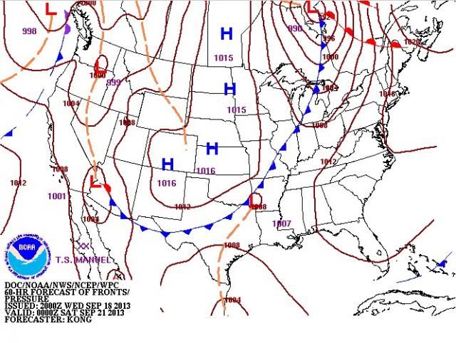
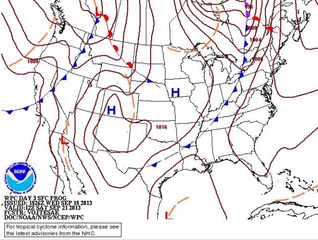
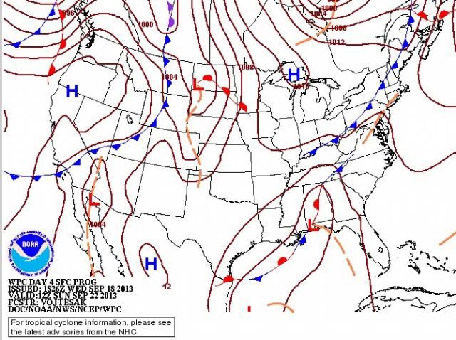
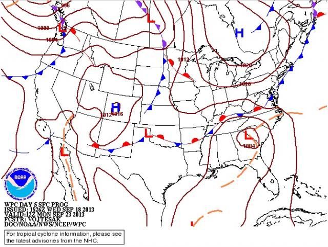
The screaming front forecast went out the window earlier today. The NCEP forecast maps show the front dissipating as it approaches the Gulf Saturday morning, then a portion of what's left becomes stationary north of our TC on Sunday morning, then completely washed out by Monday, leaving out TC (Jerry) behind. Have you seen the forecast maps?
Friday eve:

Saturday morning:

Sunday Morning:

Monday Morning:

0 likes
- SeminoleWind
- Category 1

- Posts: 359
- Age: 51
- Joined: Wed Jun 02, 2010 8:37 pm
- Location: Lake County Florida
Re: ATL: INVEST 95L - Discussion - 70% - 80%
Seen those maps  earlier tonight and thought the same thing. it looks like it gets left behind for a while.
0 likes
This post is NOT an official forecast and should not be used as such. It is just the opinion of the poster and may or may not be backed by sound meteorological data. It is NOT endorsed by any professional institution including storm2k.org For Official Information please refer to the NHC and NWS products.
- Miami Storm Tracker
- Category 4

- Posts: 916
- Age: 68
- Joined: Sun Jun 13, 2010 10:12 pm
- Location: Key Largo, Fla.
- Contact:
Re: Re:
Alyono wrote:cycloneye wrote:TropicalAnalystwx13 wrote:The system has beautiful outflow, that's for sure.
Some dry air to contend with.
I suspect there is a layer of shear beneath the outflow layer
So if I understand you correct, you can have an upper level condition that's appears to have a good outflow. But at the same time conditions at the low level may not be as it appears?
0 likes
-
ozonepete
- Professional-Met

- Posts: 4743
- Joined: Mon Sep 07, 2009 3:23 pm
- Location: From Ozone Park, NYC / Now in Brooklyn, NY
Re: ATL: INVEST 95L - Discussion - 70% - 80%
wxman57, have you seen the updated forecast maps I posted above? They were developed late this afternoon and evening after NCEP/WPC had a conference call with the NHC. They seem to have concluded together that this TC will not get picked up by the front after all. The low that you see in the southeast on Monday morning forms from cyclogenesis at the nose of a 500 mb trough that misses Jerry and leaves him behind. What do you think?
0 likes
Re: Re:
Miami Storm Tracker wrote:
So if I understand you correct, you can have an upper level condition that's appears to have a good outflow. But at the same time conditions at the low level may not be as it appears?
happens quite often
0 likes
- Miami Storm Tracker
- Category 4

- Posts: 916
- Age: 68
- Joined: Sun Jun 13, 2010 10:12 pm
- Location: Key Largo, Fla.
- Contact:
Re: Re:
Alyono wrote:Miami Storm Tracker wrote:
So if I understand you correct, you can have an upper level condition that's appears to have a good outflow. But at the same time conditions at the low level may not be as it appears?
happens quite often
Thank you so much.
0 likes
Re: Re:
Miami Storm Tracker wrote:Alyono wrote:Miami Storm Tracker wrote:
So if I understand you correct, you can have an upper level condition that's appears to have a good outflow. But at the same time conditions at the low level may not be as it appears?
happens quite often
...welcome to our dusty little piece of hell, which we affectionately refer to as, "The Atlantic"
0 likes
Andy D
(For official information, please refer to the NHC and NWS products.)
(For official information, please refer to the NHC and NWS products.)
Re: ATL: INVEST 95L - Discussion - 70% - 80%
0 likes
Andy D
(For official information, please refer to the NHC and NWS products.)
(For official information, please refer to the NHC and NWS products.)
http://www.nrlmry.navy.mil/tc-bin/tc_ho ... egreeticks
LLC looks to be well north of the swirl on satellite.
Another reminder... pay no attention to the spin in the convection. Focus on the low clouds
LLC looks to be well north of the swirl on satellite.
Another reminder... pay no attention to the spin in the convection. Focus on the low clouds
0 likes
-
ozonepete
- Professional-Met

- Posts: 4743
- Joined: Mon Sep 07, 2009 3:23 pm
- Location: From Ozone Park, NYC / Now in Brooklyn, NY
Re: ATL: INVEST 95L - Discussion - 70% - 80%
Ok, DMIN is finishing. Let's see what DMAX does. Sit back, relax, and stay up all night, lol. (Not me, though if I didn't have to work I probably would.)
0 likes
- Annie Oakley
- Category 5

- Posts: 1103
- Joined: Tue Jul 31, 2007 12:54 pm
- Location: Texas
Who is online
Users browsing this forum: No registered users and 91 guests


