ATL: INVEST 92L - Discussion

Moderator: S2k Moderators

Message
Author
RL3AO
Moderator-Pro Met
Moderator-Pro Met
Posts: 16308
Joined: Thu Jun 14, 2007 10:03 pm
Location: NC

Re: ATL: INVEST 92L - Discussion

#41 Postby RL3AO » Tue Aug 13, 2013 4:41 pm

N2FSU wrote:
ronjon wrote:Latest TAFB 72 hour forecast places a low just north of the Yucatan with a movement arrow up into the FL big bend. Looks like NHCs thinking has come around to a northern GOM solution now.


Can you post the graphic ronjon?


We've been discussing this in chat.

NHC/TAFB

Image

WPC

Image


NHC has the arrow pointing north. WPC seems to bring the wave west. This is an hour after their coordination call. I'm confused.
0 likes   

User avatar
N2FSU
S2K Supporter
S2K Supporter
Posts: 1012
Joined: Thu Sep 04, 2003 2:04 pm
Location: Tallahassee, FL

Re: ATL: INVEST 92L - Discussion

#42 Postby N2FSU » Tue Aug 13, 2013 4:44 pm

Thanks!
0 likes   

User avatar
Rgv20
S2K Supporter
S2K Supporter
Posts: 2458
Age: 37
Joined: Wed Jan 05, 2011 5:42 pm
Location: Edinburg/McAllen Tx

#43 Postby Rgv20 » Tue Aug 13, 2013 4:45 pm
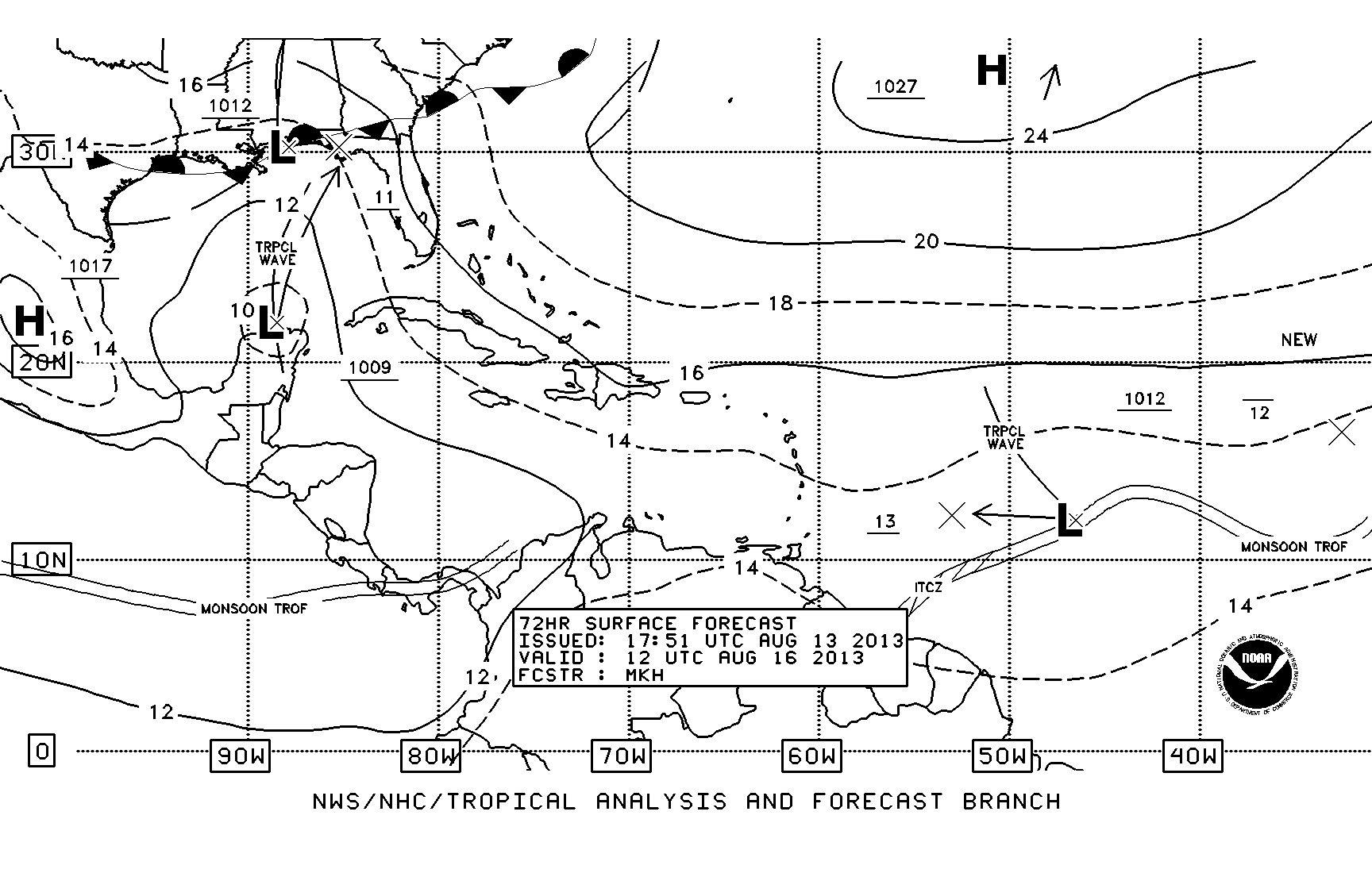
RL3AO wrote:
N2FSU wrote:
ronjon wrote:Latest TAFB 72 hour forecast places a low just north of the Yucatan with a movement arrow up into the FL big bend. Looks like NHCs thinking has come around to a northern GOM solution now.


Can you post the graphic ronjon?


We've been discussing this in chat.

NHC/TAFB

[img]http://i44.photobucket.com/albums/f38/RL3AO/atlsfc72_latestBW.gif
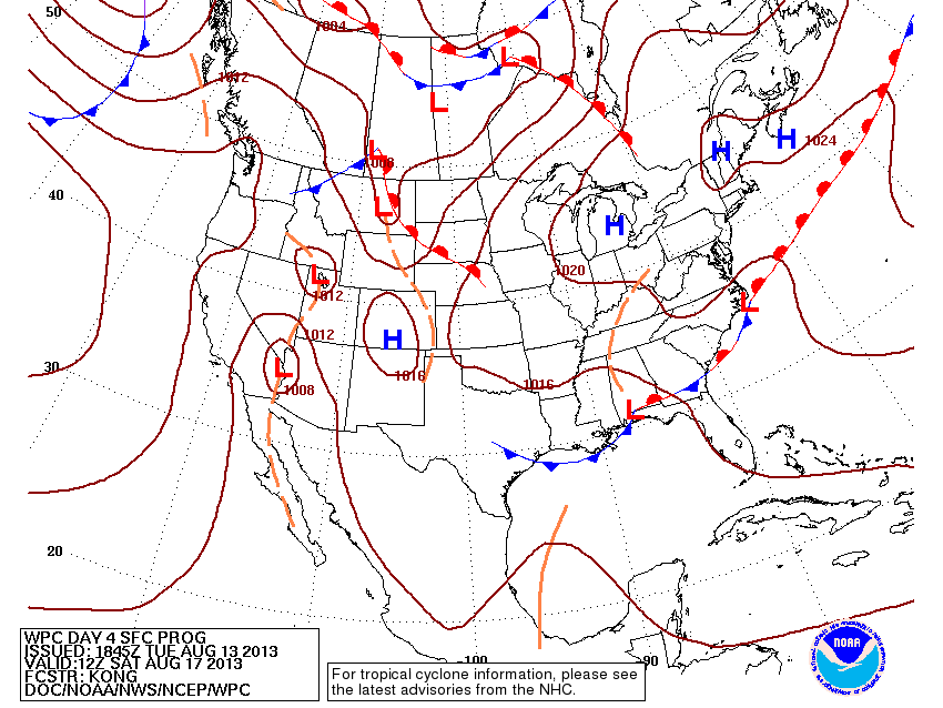
WPC

[img]http://i44.photobucket.com/albums/f38/RL3AO/9khwbg_conus.gif


NHC has the arrow pointing north. WPC seems to bring the wave west. This is an hour after their coordination call. I'm confused.


Lol I was going to say that, but on WPC discussion it said their conference call with the NHC was Monday August 12.
Last edited by Rgv20 on Tue Aug 13, 2013 4:47 pm, edited 1 time in total.
0 likes   
The following post is NOT an official forecast and should not be used as such. It is just the opinion of the poster and may or may not be backed by sound meteorological data. It is NOT endorsed by any professional institution including storm2k.org For Official Information please refer to the NHC and NWS products.

User avatar
ronjon
Category 5
Category 5
Posts: 4672
Joined: Fri Aug 19, 2005 5:17 pm
Location: Hernando Beach, FL

Re: ATL: INVEST 92L - Discussion

#44 Postby ronjon » Tue Aug 13, 2013 4:46 pm

N2FSU wrote:
ronjon wrote:Latest TAFB 72 hour forecast places a low just north of the Yucatan with a movement arrow up into the FL big bend. Looks like NHCs thinking has come around to a northern GOM solution now.


Can you post the graphic ronjon?


The moderator posted the graphic but here is the link.

http://www.nhc.noaa.gov/tafb_latest/atlsfc72_latestBW.gif
0 likes   

Dean4Storms
S2K Supporter
S2K Supporter
Posts: 6356
Age: 61
Joined: Sun Aug 31, 2003 1:01 pm
Location: Miramar Bch. FL

#45 Postby Dean4Storms » Tue Aug 13, 2013 4:48 pm

Well at least they have both scenario's covered. :lol:
0 likes   

Dean4Storms
S2K Supporter
S2K Supporter
Posts: 6356
Age: 61
Joined: Sun Aug 31, 2003 1:01 pm
Location: Miramar Bch. FL

#46 Postby Dean4Storms » Tue Aug 13, 2013 4:57 pm

Anyone else seeing the circulation near 16.5N 83W moving NW?
0 likes   

tolakram
Admin
Admin
Posts: 19184
Age: 61
Joined: Sun Aug 27, 2006 8:23 pm
Location: Florence, KY (name is Mark)

Re: ATL: INVEST 92L - Discussion

#47 Postby tolakram » Tue Aug 13, 2013 5:02 pm

Live visible: http://wwwghcc.msfc.nasa.gov/cgi-bin/ge ... mframes=15

When sped up I believe I see a low level circulation, but it may be in the mid levels.
0 likes   
M a r k
- - - - -
Join us in chat: Storm2K Chatroom Invite. Android and IOS apps also available.

The posts in this forum are NOT official forecasts and should not be used as such. Posts are NOT endorsed by any professional institution or STORM2K.org. For official information and forecasts, please refer to NHC and NWS products.

User avatar
NDG
S2K Supporter
S2K Supporter
Posts: 14950
Joined: Sun Jul 09, 2006 10:14 pm
Location: Orlando, FL

Re: ATL: INVEST 92L - Discussion

#48 Postby NDG » Tue Aug 13, 2013 5:09 pm

tolakram wrote:Live visible: http://wwwghcc.msfc.nasa.gov/cgi-bin/ge ... mframes=15

When sped up I believe I see a low level circulation, but it may be in the mid levels.


Well defined MLC but circulation at the surface remains broad, I do not see a sign of a LLC, yet.
0 likes   

User avatar
tropicwatch
Category 5
Category 5
Posts: 3206
Age: 60
Joined: Sat Jun 02, 2007 10:01 am
Location: Panama City Florida
Contact:

Re: ATL: INVEST 92L - Discussion

#49 Postby tropicwatch » Tue Aug 13, 2013 5:29 pm

NDG wrote:
tolakram wrote:Live visible: http://wwwghcc.msfc.nasa.gov/cgi-bin/ge ... mframes=15

When sped up I believe I see a low level circulation, but it may be in the mid levels.


Well defined MLC but circulation at the surface remains broad, I do not see a sign of a LLC, yet.


Does not appear to have made it to the surface yet.

Image
0 likes   
Tropicwatch


Agnes 72', Eloise 75, Elena 85', Kate 85', Charley 86', Florence 88', Beryl 94', Dean 95', Erin 95', Opal 95', Earl 98', Georges 98', Ivan 2004', Arlene 2005', Dennis 2005', Ida 2009' Debby 2012' Irma 2017' Michael 2018'

User avatar
wxman57
Moderator-Pro Met
Moderator-Pro Met
Posts: 22512
Age: 66
Joined: Sat Jun 21, 2003 8:06 pm
Location: Houston, TX (southwest)

Re: ATL: INVEST 92L - Discussion

#50 Postby wxman57 » Tue Aug 13, 2013 5:38 pm

NDG wrote:
tolakram wrote:Live visible: http://wwwghcc.msfc.nasa.gov/cgi-bin/ge ... mframes=15

When sped up I believe I see a low level circulation, but it may be in the mid levels.


Well defined MLC but circulation at the surface remains broad, I do not see a sign of a LLC, yet.


Agree on the MLC in that area. Strong rotation, though. I suspect NHC will up the development chances this evening. At least 50%. Should have been there or higher 2 days ago.
0 likes   

User avatar
ronjon
Category 5
Category 5
Posts: 4672
Joined: Fri Aug 19, 2005 5:17 pm
Location: Hernando Beach, FL

Re: ATL: INVEST 92L - Discussion

#51 Postby ronjon » Tue Aug 13, 2013 5:40 pm

Latest GFS shows two areas of vorticity - one west of JAM and one off the NE coast of NIC. The latter one moves inland as the northern one appears to absorb its energy and move to the NE tip of the Yuc.

850 mb GFS
0 likes   

User avatar
ronjon
Category 5
Category 5
Posts: 4672
Joined: Fri Aug 19, 2005 5:17 pm
Location: Hernando Beach, FL

Re: ATL: INVEST 92L - Discussion

#52 Postby ronjon » Tue Aug 13, 2013 5:51 pm

The way the convection is blowing up tonight I'm not sure they should have cancelled RECON for tomorrow.

http://rammb.cira.colostate.edu/ramsdis/online/loop_timestamp.asp?data_folder=tropical/tropical_ge_4km_visir2_floater_2&width=640&height=480
0 likes   

HurricaneDREW92
Category 1
Category 1
Posts: 320
Age: 25
Joined: Sun Jul 28, 2013 11:56 am
Location: Boston, MA

Re: ATL: INVEST 92L - Discussion

#53 Postby HurricaneDREW92 » Tue Aug 13, 2013 6:01 pm

ronjon wrote:The way the convection is blowing up tonight I'm not sure they should have cancelled RECON for tomorrow.

http://rammb.cira.colostate.edu/ramsdis/online/loop_timestamp.asp?data_folder=tropical/tropical_ge_4km_visir2_floater_2&width=640&height=480

Likely they'll reactivate it.

Latest Visible:
Image
0 likes   
This post is NOT AN OFFICIAL FORECAST and should not be used as such. It is just the opinion of the poster and may or may not be backed by sound meteorological data. It is NOT endorsed by any professional institution including storm2k.org. For Official Information please refer to the NHC and NWS products.

-THE ABOVE IS THE OPINION OF DREW ONLY

Frank P
S2K Supporter
S2K Supporter
Posts: 2408
Joined: Fri Aug 29, 2003 10:52 am
Location: Biloxi Beach, Ms

Re: ATL: INVEST 92L - Discussion

#54 Postby Frank P » Tue Aug 13, 2013 6:01 pm

yep, hints of broad type banding developing also to the north and east... looks like it continues to slowly get better organized... my amateur opinion only....
0 likes   

User avatar
TheStormExpert
Category 5
Category 5
Posts: 8487
Age: 30
Joined: Wed Feb 16, 2011 5:38 pm
Location: Palm Beach Gardens, FL

Re: ATL: INVEST 92L - Discussion

#55 Postby TheStormExpert » Tue Aug 13, 2013 6:10 pm

ronjon wrote:The way the convection is blowing up tonight I'm not sure they should have cancelled RECON for tomorrow.

http://rammb.cira.colostate.edu/ramsdis/online/loop_timestamp.asp?data_folder=tropical/tropical_ge_4km_visir2_floater_2&width=640&height=480

Yesterday I was shocked that they planned to send RECON out, today I'm shocked they decided to cancel the RECON flight. :lol:
0 likes   
The following post is NOT an official forecast and should not be used as such. It is just the opinion of the poster and may or may not be backed by sound meteorological data. It is NOT endorsed by storm2k.org.

User avatar
KatDaddy
Category 5
Category 5
Posts: 2815
Joined: Mon Oct 21, 2002 6:23 pm
Location: League City, Texas

#56 Postby KatDaddy » Tue Aug 13, 2013 6:11 pm

Quite a bit more convection this evening across the W Central Caribbean as well as better organization. It will be interesting to see if it has organized additionally overnight as well as the model runs tomorrow morning.
0 likes   
The following post is NOT an official forecast and should not be used as such. It is just the opinion of the poster and may or may not be backed by sound meteorological data. It is NOT endorsed by any professional institution including storm2k.org For Official Information please refer to the NHC and NWS products.

User avatar
tropicwatch
Category 5
Category 5
Posts: 3206
Age: 60
Joined: Sat Jun 02, 2007 10:01 am
Location: Panama City Florida
Contact:

#57 Postby tropicwatch » Tue Aug 13, 2013 6:12 pm

I am kind of surprised that there is no floater yet.
0 likes   
Tropicwatch


Agnes 72', Eloise 75, Elena 85', Kate 85', Charley 86', Florence 88', Beryl 94', Dean 95', Erin 95', Opal 95', Earl 98', Georges 98', Ivan 2004', Arlene 2005', Dennis 2005', Ida 2009' Debby 2012' Irma 2017' Michael 2018'

User avatar
northjaxpro
S2K Supporter
S2K Supporter
Posts: 8900
Joined: Mon Sep 27, 2010 11:21 am
Location: Jacksonville, FL

Re: ATL: INVEST 92L - Discussion

#58 Postby northjaxpro » Tue Aug 13, 2013 6:12 pm

ronjon wrote:Latest GFS shows two areas of vorticity - one west of JAM and one off the NE coast of NIC. The latter one moves inland as the northern one appears to absorb its energy and move to the NE tip of the Yuc.

850 mb GFS


:uarrow:Yes, I think the vort west of Jamaica will become the dominant one as time progresses.
0 likes   
NEVER, EVER SAY NEVER in the tropics and weather in general, and most importantly, with life itself!!

________________________________________________________________________________________

Fay 2008 Beryl 2012 Debby 2012 Colin 2016 Hermine 2016 Julia 2016 Matthew 2016 Irma 2017 Dorian 2019

User avatar
CaneCurious
Tropical Storm
Tropical Storm
Posts: 159
Joined: Wed Aug 25, 2004 1:40 pm
Location: Kenner, LA

Re: ATL: INVEST 92L - Discussion

#59 Postby CaneCurious » Tue Aug 13, 2013 6:23 pm

northjaxpro wrote:
ronjon wrote:Latest GFS shows two areas of vorticity - one west of JAM and one off the NE coast of NIC. The latter one moves inland as the northern one appears to absorb its energy and move to the NE tip of the Yuc.

850 mb GFS


:uarrow:Yes, I think the vort west of Jamaica will become the dominant one as time progresses.

If that vort takes charge wouldn't it go more towards he BOC than the Northern Gulf
0 likes   

ozonepete
Professional-Met
Professional-Met
Posts: 4743
Joined: Mon Sep 07, 2009 3:23 pm
Location: From Ozone Park, NYC / Now in Brooklyn, NY

Re: ATL: INVEST 92L - Discussion

#60 Postby ozonepete » Tue Aug 13, 2013 6:31 pm

CaneCurious wrote:
northjaxpro wrote:
ronjon wrote:Latest GFS shows two areas of vorticity - one west of JAM and one off the NE coast of NIC. The latter one moves inland as the northern one appears to absorb its energy and move to the NE tip of the Yuc.

850 mb GFS


:uarrow:Yes, I think the vort west of Jamaica will become the dominant one as time progresses.

If that vort takes charge wouldn't it go more towards he BOC than the Northern Gulf


No. If the COC west of Jamaica takes precedence than the mid-level flow will carry it more northwestward to the northern Yucatan. If the COC develops closer to the Nicaragua coast the mid-level flow is more westerly there and will steer it more westward into the BOC.
0 likes   


Return to “2013”

Who is online

Users browsing this forum: No registered users and 6 guests