WPAC: SOULIK- Post-Tropical

Moderator: S2k Moderators

Message
Author
User avatar
HURAKAN
Professional-Met
Professional-Met
Posts: 46086
Age: 37
Joined: Thu May 20, 2004 4:34 pm
Location: Key West, FL
Contact:

Re:

#61 Postby HURAKAN » Mon Jul 08, 2013 11:06 pm

Meow wrote:No one cares JMA. :roll: It upgraded Soulik to a typhoon at 00Z.


It's more interesting than Chantal, that's for sure!! I did mention it on my fb page! I don't post much here anymore.

Image
0 likes   

User avatar
euro6208
Category 5
Category 5
Posts: 18547
Joined: Mon Mar 08, 2004 7:50 pm
Location: Guam

Re: WPAC: SOULIK- Typhoon

#62 Postby euro6208 » Mon Jul 08, 2013 11:21 pm

209
WTPQ31 PGUM 090339
TCPPQ1

BULLETIN
TYPHOON SOULIK (07W) ADVISORY NUMBER 6
NATIONAL WEATHER SERVICE TIYAN GU WP072013
200 PM CHST TUE JUL 9 2013

...TYPHOON SOULIK (07W) INTENSIFYING NORTHWEST OF THE MARIANAS...

WATCHES AND WARNINGS
--------------------

NONE.

SUMMARY OF 100 PM CHST...0300 UTC...INFORMATION
-----------------------------------------------

LOCATION...19.7N 139.8E

ABOUT 390 MILES WEST OF AGRIHAN
ABOUT 405 MILES WEST-NORTHWEST OF PAGAN
ABOUT 505 MILES NORTHWEST OF SAIPAN...AND
ABOUT 540 MILES NORTHWEST OF GUAM.

MAXIMUM SUSTAINED WINDS...85 MPH
PRESENT MOVEMENT...W OR 280 DEGREES AT 13 MPH

DISCUSSION AND OUTLOOK
----------------------

AT 100 PM CHST...0300 UTC...THE CENTER OF TYPHOON SOULIK WAS LOCATED
BY SATELLITE NEAR LATITUDE 19.7 NORTH...LONGITUDE 139.8 EAST.

TYPHOON SOULIK IS MOVING WEST AT 13 MPH. SOULIK IS EXPECTED TO
REMAIN ON THIS GENERAL TRACK AT LEAST THROUGH THURSDAY.

MAXIMUM SUSTAINED WINDS ARE NOW 85 MPH. TYPHOON FORCE WINDS EXTEND
OUT TO 30 MILES FROM THE CENTER. TROPICAL STORM FORCE WINDS EXTEND
OUT TO 125 MILES FROM THE CENTER. TYPHOON SOULIK IS EXPECTED TO
CONTINUE INTENSIFYING THROUGH THURSDAY.

NEXT ADVISORY
-------------

THE NEXT SCHEDULED ADVISORY WILL BE ISSUED BY THE NATIONAL WEATHER
SERVICE THIS EVENING AT 800 PM.

$$

WILLIAMS
0 likes   
Remember, all of my post aren't official. For official warnings and discussions, Please refer to your local NWS products...

NWS for the Western Pacific

https://www.weather.gov/gum/

User avatar
euro6208
Category 5
Category 5
Posts: 18547
Joined: Mon Mar 08, 2004 7:50 pm
Location: Guam

Re: WPAC: SOULIK- Typhoon

#63 Postby euro6208 » Mon Jul 08, 2013 11:41 pm

Image
0 likes   
Remember, all of my post aren't official. For official warnings and discussions, Please refer to your local NWS products...

NWS for the Western Pacific

https://www.weather.gov/gum/

User avatar
mrbagyo
Category 5
Category 5
Posts: 3617
Age: 32
Joined: Thu Apr 12, 2012 9:18 am
Location: 14.13N 120.98E
Contact:

Re: WPAC: SOULIK- Typhoon

#64 Postby mrbagyo » Tue Jul 09, 2013 12:53 am

looks impressive in this visible image,
Image

but in reality... it's still some having trouble closing it out.
Image
0 likes   
The posts in this forum are NOT official forecast and should not be used as such. They are just the opinion of the poster and may or may not be backed by sound meteorological data. They are NOT endorsed by any professional institution or storm2k.org. For official information, please refer to RSMC, NHC and NWS products.

RobWESTPACWX
WestPACMet
WestPACMet
Posts: 1616
Joined: Fri Sep 17, 2010 2:26 am
Location: Tokyo, Japan
Contact:

#65 Postby RobWESTPACWX » Tue Jul 09, 2013 1:31 am

Much more interesting than Chantel. Models still split on where exactly it will go. I hope they come together today.

Image
0 likes   
Satellites, Charts and Forecasting tools for East Asia at WESTERNPACIFICWEATHER.COM

Typhoon Hunter
WesternPacificWeather.com
Posts: 1215
Age: 40
Joined: Wed Oct 11, 2006 11:37 am
Location: Hong Kong
Contact:

Re: WPAC: SOULIK- Typhoon

#66 Postby Typhoon Hunter » Tue Jul 09, 2013 2:43 am

Eyewall fully closed off now, it's clearly utterly exploding!

Image

Uploaded with ImageShack.us
0 likes   
James - Documenting typhoons...

http://www.youtube.com/TyphoonHunter

stormstrike
Tropical Storm
Tropical Storm
Posts: 159
Joined: Thu Nov 29, 2012 12:37 am

Re: WPAC: SOULIK- Typhoon

#67 Postby stormstrike » Tue Jul 09, 2013 3:01 am

oh so pretty... :wink:

Image
0 likes   

User avatar
xtyphooncyclonex
Category 5
Category 5
Posts: 3688
Age: 22
Joined: Sat Dec 08, 2012 9:07 am
Location: Cebu City
Contact:

#68 Postby xtyphooncyclonex » Tue Jul 09, 2013 4:32 am

I wouldn't be surprised if this develops into a Category 5, which I think will.
0 likes   
REMINDER: My opinions that I, or any other NON Pro-Met in this forum, are unofficial. Please do not take my opinions as an official forecast and warning. I am NOT a meteorologist. Following my forecasts blindly may lead to false alarm, danger and risk if official forecasts from agencies are ignored.

phwxenthusiast
Category 2
Category 2
Posts: 637
Joined: Wed Mar 24, 2010 3:10 am
Location: Holbrook, NY (Long Island)

Re:

#69 Postby phwxenthusiast » Tue Jul 09, 2013 6:16 am

xtyphooncyclonex wrote:I wouldn't be surprised if this develops into a Category 5, which I think will.


there's a chance imo... but there's still the possibility of an EWRC which could hamper the intensification... latest MWI hinting of what looks like a concentric eyewall that could probably continue forming over the next hours... not sure if this will definitely lead to an eyewall replacement but the possibility is there...

Image

Personal Forecast Disclaimer:
The posts in this forum are NOT official forecast and should not be used as such. They are just the opinion of the poster and may or may not be backed by sound meteorological data. They are NOT endorsed by any professional institution or storm2k.org. For official information, please refer to the NHC and NWS products.
0 likes   

dexterlabio
Category 5
Category 5
Posts: 3408
Joined: Sat Oct 24, 2009 11:50 pm

Re: WPAC: SOULIK- Typhoon

#70 Postby dexterlabio » Tue Jul 09, 2013 6:53 am

I agree that eyewall replacement could hamper further intensification. But the southern eyewall looks intense and if favorable condition stays and allows Soulik to intensify even more, could lead to a thicker, intense eyewall... just like Megi's, the eyewall was so thick that it never underwent EWRC during its peak. I also think it's quite early for EWRC to take place for now but we'll see.
0 likes   
Personal Forecast Disclaimer:
The posts in this forum are NOT official forecast and should not be used as such. They are just the opinion of the poster and may or may not be backed by sound meteorological data. They are NOT endorsed by any professional institution or storm2k.org. For official information, please refer to the NHC and NWS products.

dexterlabio
Category 5
Category 5
Posts: 3408
Joined: Sat Oct 24, 2009 11:50 pm

#71 Postby dexterlabio » Tue Jul 09, 2013 7:40 am

Geez, if the Euro solution pans out..i can't imagine how those high rise buildings in Taipei will fare when Soulik's core passes over. Flight level winds are stronger than surface winds which is expected to reach Cat4 strength, at least...
0 likes   
Personal Forecast Disclaimer:
The posts in this forum are NOT official forecast and should not be used as such. They are just the opinion of the poster and may or may not be backed by sound meteorological data. They are NOT endorsed by any professional institution or storm2k.org. For official information, please refer to the NHC and NWS products.

User avatar
euro6208
Category 5
Category 5
Posts: 18547
Joined: Mon Mar 08, 2004 7:50 pm
Location: Guam

Re: WPAC: SOULIK- Typhoon

#72 Postby euro6208 » Tue Jul 09, 2013 7:42 am

CI# /Pressure/ Vmax
5.3 / 956.9mb/ 97.2kt

Final T# Adj T# Raw T#
5.3 5.3 6.8

:eek: :eek: :eek:


Image
0 likes   
Remember, all of my post aren't official. For official warnings and discussions, Please refer to your local NWS products...

NWS for the Western Pacific

https://www.weather.gov/gum/

RL3AO
Moderator-Pro Met
Moderator-Pro Met
Posts: 16308
Joined: Thu Jun 14, 2007 10:03 pm
Location: NC

#73 Postby RL3AO » Tue Jul 09, 2013 7:50 am

I love watching these WPac systems bomb out. Such a sight to see.
0 likes   

User avatar
euro6208
Category 5
Category 5
Posts: 18547
Joined: Mon Mar 08, 2004 7:50 pm
Location: Guam

Re: WPAC: SOULIK- Typhoon

#74 Postby euro6208 » Tue Jul 09, 2013 7:50 am

Based on imagery alone and the continued rapid intensification, the intensity is likely in the neighborhood of 115 knots a category 4 typhoon!


The posts in this forum are NOT official forecast and should not be used as such. They are just the opinion of the poster and may or may not be backed by sound meteorological data. They are NOT endorsed by any professional institution or storm2k.org. For official information, please refer to the JTWC and JMA products.
0 likes   
Remember, all of my post aren't official. For official warnings and discussions, Please refer to your local NWS products...

NWS for the Western Pacific

https://www.weather.gov/gum/

RL3AO
Moderator-Pro Met
Moderator-Pro Met
Posts: 16308
Joined: Thu Jun 14, 2007 10:03 pm
Location: NC

Re: WPAC: SOULIK- Typhoon

#75 Postby RL3AO » Tue Jul 09, 2013 7:52 am

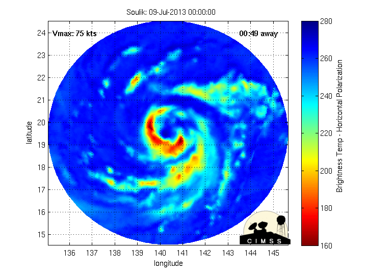
euro6208 wrote:Based on imagery alone and the continued rapid intensification, the intensity is likely in the neighborhood of 115 knots a category 4 typhoon!


The posts in this forum are NOT official forecast and should not be used as such. They are just the opinion of the poster and may or may not be backed by sound meteorological data. They are NOT endorsed by any professional institution or storm2k.org. For official information, please refer to the JTWC and JMA products.


My uneducated eye would put it around 105kts but strengthening rapidly. I've noticed 115kt storms tend to have a very round eye while this one is still a bit jagged.
0 likes   

User avatar
xtyphooncyclonex
Category 5
Category 5
Posts: 3688
Age: 22
Joined: Sat Dec 08, 2012 9:07 am
Location: Cebu City
Contact:

Re: WPAC: SOULIK- Typhoon

#76 Postby xtyphooncyclonex » Tue Jul 09, 2013 8:15 am

JMA's Latest Warning:
<Analyses at 09/12 UTC>
Scale -
Intensity Strong
Center position N20°20'(20.3°)
E138°05'(138.1°)
Direction and speed of movement W 20km/h(11kt)
Central pressure 950hPa
Maximum wind speed near the center 40m/s(80kt)
Maximum wind gust speed 60m/s(115kt)
Area of 50kt winds or more ALL150km(80NM)
Area of 30kt winds or more ALL440km(240NM)

<Forecast for 10/00 UTC>
Intensity Very Strong
Center position of probability circle N20°55'(20.9°)
E135°40'(135.7°)
Direction and speed of movement WNW 20km/h(12kt)
Central pressure 935hPa
Maximum wind speed near the center 45m/s(90kt)
Maximum wind gust speed 65m/s(130kt)
Radius of probability circle 90km(50NM)
Storm warning area ALL260km(140NM)

<Forecast for 10/12 UTC>
Intensity Very Strong
Center position of probability circle N21°30'(21.5°)
E133°20'(133.3°)
Direction and speed of movement WNW 20km/h(12kt)
Central pressure 925hPa
Maximum wind speed near the center 50m/s(95kt)
Maximum wind gust speed 70m/s(135kt)
Radius of probability circle 140km(75NM)
Storm warning area ALL350km(190NM)

<Forecast for 11/12 UTC>
Intensity Very Strong
Center position of probability circle N22°50'(22.8°)
E128°25'(128.4°)
Direction and speed of movement WNW 20km/h(12kt)
Central pressure 920hPa
Maximum wind speed near the center 50m/s(95kt)
Maximum wind gust speed 70m/s(135kt)
Radius of probability circle 260km(140NM)
Storm warning area ALL520km(280NM)

<Forecast for 12/12 UTC>
Intensity Very Strong
Center position of probability circle N24°30'(24.5°)
E123°30'(123.5°)
Direction and speed of movement WNW 20km/h(12kt)
Central pressure 920hPa
Maximum wind speed near the center 50m/s(95kt)
Maximum wind gust speed 70m/s(135kt)
Radius of probability circle 390km(210NM)
Storm warning area ALL650km(350NM)
0 likes   
REMINDER: My opinions that I, or any other NON Pro-Met in this forum, are unofficial. Please do not take my opinions as an official forecast and warning. I am NOT a meteorologist. Following my forecasts blindly may lead to false alarm, danger and risk if official forecasts from agencies are ignored.

dexterlabio
Category 5
Category 5
Posts: 3408
Joined: Sat Oct 24, 2009 11:50 pm

Re: WPAC: SOULIK- Typhoon

#77 Postby dexterlabio » Tue Jul 09, 2013 8:26 am

RL3AO wrote:

My uneducated eye would put it around 105kts but strengthening rapidly. I've noticed 115kt storms tend to have a very round eye while this one is still a bit jagged.


Yeah agreed...still looks like a Cat3 to me, but we might be seeing a different picture tomorrow if conditions remain the same. Still a lot of time before it reaches Taiwan/Southeastern China coast.
0 likes   
Personal Forecast Disclaimer:
The posts in this forum are NOT official forecast and should not be used as such. They are just the opinion of the poster and may or may not be backed by sound meteorological data. They are NOT endorsed by any professional institution or storm2k.org. For official information, please refer to the NHC and NWS products.

User avatar
mrbagyo
Category 5
Category 5
Posts: 3617
Age: 32
Joined: Thu Apr 12, 2012 9:18 am
Location: 14.13N 120.98E
Contact:

Re: WPAC: SOULIK- Typhoon

#78 Postby mrbagyo » Tue Jul 09, 2013 8:45 am

WOW!!!
Image

cat 3 to low end cat 4 in my opinion( like Nesat ) for NOW.
I don't know tomorrow??? It might continue bombing to become a cat 4 or even a cat 5 since it will enter one of warmest area in the whole Pacific.
the Philippine sea is one of the Cradle of Rapid intensification(ei. Megi, Nanmadol, Jelawat, Sanba, and many many more)
0 likes   
The posts in this forum are NOT official forecast and should not be used as such. They are just the opinion of the poster and may or may not be backed by sound meteorological data. They are NOT endorsed by any professional institution or storm2k.org. For official information, please refer to RSMC, NHC and NWS products.

User avatar
xtyphooncyclonex
Category 5
Category 5
Posts: 3688
Age: 22
Joined: Sat Dec 08, 2012 9:07 am
Location: Cebu City
Contact:

Re: WPAC: SOULIK- Typhoon

#79 Postby xtyphooncyclonex » Tue Jul 09, 2013 8:50 am

mrbagyo wrote:WOW!!!
Image

cat 3 to low end cat 4 in my opinion( like Nesat ) for NOW.
I don't know tomorrow??? It might continue bombing to become a cat 4 or even a cat 5 since it will enter one of warmest area in the whole Pacific.
the Philippine sea is one of the Cradle of Rapid intensification(ei. Megi, Nanmadol, Jelawat, Sanba, and many many more)

that looks AWESOME!!!
0 likes   
REMINDER: My opinions that I, or any other NON Pro-Met in this forum, are unofficial. Please do not take my opinions as an official forecast and warning. I am NOT a meteorologist. Following my forecasts blindly may lead to false alarm, danger and risk if official forecasts from agencies are ignored.

User avatar
jaguarjace
Category 4
Category 4
Posts: 975
Age: 29
Joined: Sat Jun 11, 2011 7:38 am
Location: Khon Kaen, Thailand

Re: WPAC: SOULIK- Typhoon

#80 Postby jaguarjace » Tue Jul 09, 2013 10:49 am

A well defined eyewall on the last frame.
Image
0 likes   
Owner of the Tropical Archive YouTube channel
Web Developer at Force Thirteen
Twitter/X : @force13_support


Return to “2013”

Who is online

Users browsing this forum: No registered users and 7 guests