ATL: INVEST 92L - Models
Moderator: S2k Moderators
-
Tyler Penland
- Tropical Depression

- Posts: 63
- Joined: Fri Aug 19, 2011 12:32 pm
- Location: Blowing Rock, NC
Of note the CMC initialized that energy in the Caribbean as a giant blob instead of two distinct pieces. JMO of course but that could account for part of that weird run. The GFS was spot on with the latest CIMMS analysis.
0 likes
****The above is NOT AN OFFICIAL FORECAST. I am in no way affiliated with the NWS or storm2k, and most likely don't share their opinion. Please refer to NWS/NHC products for official advisories/warnings/forecasts.****
But if you insist, trust me, I'm a physicist.
But if you insist, trust me, I'm a physicist.

Re: ATL: INVEST 92L - Models
RGV....plenty of ridge there with weakness along the TX coast....this might ride up the coast...the NAVGEM had a simialr solution a few days ago
0 likes
-
HouTXmetro

- Category 5

- Posts: 3949
- Joined: Sun Jun 13, 2004 6:00 pm
- Location: District of Columbia, USA
Re: ATL: INVEST 92L - Models
CMC reminds me of Claudette 2003

0 likes
[Disclaimer: My Amateur Opinion, please defer to your local authorities or the NHC for Guidance.]
-
CYCLONE MIKE
- Category 5
- Posts: 2183
- Joined: Tue Aug 31, 2004 6:04 pm
- Location: Gonzales, LA
Re: ATL: INVEST 92L - Models
Rules should be when posting any cmc model run should have to include disclaimer... For entertainment purposes only 
0 likes
Re: ATL: INVEST 92L - Models
yeah Claudette really got her act together quickly as it approached...
0 likes
-
southerngale

- Retired Staff

- Posts: 27418
- Joined: Thu Oct 10, 2002 1:27 am
- Location: Southeast Texas (Beaumont area)
Re: ATL: INVEST 92L - Models
CYCLONE MIKE wrote:Rules should be when posting any cmc model run should have to include disclaimer... For entertainment purposes only
Why? They all have their strengths and weaknesses and none of them are always right. Of course there are people who make fun of every model that exists, so maybe we should nix them all and just wing it.
0 likes
Please support Storm2k by making a donation today. It is greatly appreciated! Click here: 
 my Cowboys my Rockets my Astros
my Cowboys my Rockets my Astros
If I recall the CMC was the only one that got Andrea's intensity right--the rest of the models kept it barely a tropical storm.
0 likes
The above post is not official and should not be used as such. It is the opinion of the poster and may or may not be backed by sound meteorological data. It is not endorsed by any professional institution or storm2k.org. For official information, please refer to the NHC and NWS products.
-
Hurricane Alexis

- Category 2

- Posts: 683
- Age: 29
- Joined: Thu Jun 14, 2012 7:59 pm
- Location: Miami,Florida
Re: ATL: INVEST 92L - Models
CYCLONE MIKE wrote:Rules should be when posting any cmc model run should have to include disclaimer... For entertainment purposes only
It's actually doing pretty good this year in comparison to last year.
0 likes
Personal Forecast Disclaimer:
The posts in this forum are NOT official forecast and should not be used as such. They are just the opinion of the poster and may or may not be backed by sound meteorological data. They are NOT endorsed by any professional institution or storm2k.org. For official information, please refer to the NHC and NWS products.
The posts in this forum are NOT official forecast and should not be used as such. They are just the opinion of the poster and may or may not be backed by sound meteorological data. They are NOT endorsed by any professional institution or storm2k.org. For official information, please refer to the NHC and NWS products.

Re: ATL: INVEST 92L - Models
PTrackerLA wrote:CMC 132 Hr
984mb turning WNW towards southern Texas?
Is that turn due to the front?
0 likes
-
Rgv20

- S2K Supporter

- Posts: 2466
- Age: 39
- Joined: Wed Jan 05, 2011 5:42 pm
- Location: Edinburg/McAllen Tx
0zHWRF 126hr Forecast has it just east of Brownsville......This should be taken with a grain of salt as the HWRF does a poor job on intensity with Invests.

Uploaded with ImageShack.us

Uploaded with ImageShack.us
0 likes
The following post is NOT an official forecast and should not be used as such. It is just the opinion of the poster and may or may not be backed by sound meteorological data. It is NOT endorsed by any professional institution including storm2k.org For Official Information please refer to the NHC and NWS products.
-
HouTXmetro
- Category 5
- Posts: 3949
- Joined: Sun Jun 13, 2004 6:00 pm
- Location: District of Columbia, USA
-
Rgv20
- S2K Supporter
- Posts: 2466
- Age: 39
- Joined: Wed Jan 05, 2011 5:42 pm
- Location: Edinburg/McAllen Tx
LaBreeze wrote:PTrackerLA wrote:CMC 132 Hr [img]http://i.imgur.com/8tUwZ8z.png
984mb turning WNW towards southern Texas?
Is that turn due to the front?
Is due to a building ridge to its North.
0zCMC 500mb Heights Anomalies day 6

Uploaded with ImageShack.us
0zGFS Ensembles 500mb Heights Anomalies day 6

Uploaded with ImageShack.us
0 likes
The following post is NOT an official forecast and should not be used as such. It is just the opinion of the poster and may or may not be backed by sound meteorological data. It is NOT endorsed by any professional institution including storm2k.org For Official Information please refer to the NHC and NWS products.
-
Rgv20
- S2K Supporter
- Posts: 2466
- Age: 39
- Joined: Wed Jan 05, 2011 5:42 pm
- Location: Edinburg/McAllen Tx
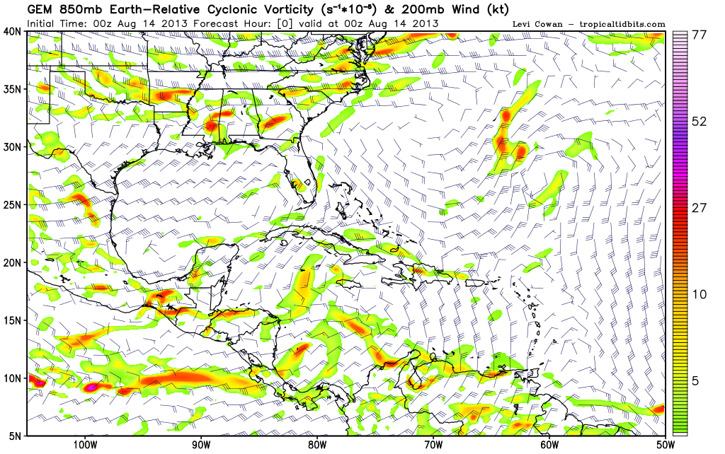
Looking at the 850mb Vorticity of the 0zECMWF looks similar to the 0zGFS...My head hurts!
0 likes
The following post is NOT an official forecast and should not be used as such. It is just the opinion of the poster and may or may not be backed by sound meteorological data. It is NOT endorsed by any professional institution including storm2k.org For Official Information please refer to the NHC and NWS products.
-
JonathanBelles
- Professional-Met

- Posts: 11430
- Age: 35
- Joined: Sat Dec 24, 2005 9:00 pm
- Location: School: Florida State University (Tallahassee, FL) Home: St. Petersburg, Florida
- Contact:
Re:
Rgv20 wrote:Looking at the 850mb Vorticity the 0zECMWF looks similar to the 0zGFS...My head hurts!
You found something in tonight's euro? I didn't see much of anything. Maybe a terrible initialization, forecast, and ending...
0 likes
-
Rgv20
- S2K Supporter
- Posts: 2466
- Age: 39
- Joined: Wed Jan 05, 2011 5:42 pm
- Location: Edinburg/McAllen Tx
0 likes
The following post is NOT an official forecast and should not be used as such. It is just the opinion of the poster and may or may not be backed by sound meteorological data. It is NOT endorsed by any professional institution including storm2k.org For Official Information please refer to the NHC and NWS products.

-
Dean4Storms
- S2K Supporter
- Posts: 6358
- Age: 63
- Joined: Sun Aug 31, 2003 1:01 pm
- Location: Miramar Bch. FL
-
Blown Away

- S2K Supporter
- Posts: 10253
- Joined: Wed May 26, 2004 6:17 am
Re: ATL: INVEST 92L - Models

Shear may become an issue longterm per 00z...
0 likes
Hurricane Eye Experience: David 79, Irene 99, Frances 04, Jeanne 04, Wilma 05… Hurricane Brush Experience: Andrew 92, Erin 95, Floyd 99, Matthew 16, Irma 17, Ian 22, Nicole 22…
Who is online
Users browsing this forum: No registered users and 48 guests